The Name on the Map
Read the entries on this site for the bridges of the eastern canal ring and one sentence comes back again and again: a bridge stood here centuries ago, because Daniël Stalpaert drew it on his map of 1662. It appears in the posts on the Herengracht, the Keizersgracht and the Prinsengracht, on the Leidsegracht and the Reguliersgracht, and out on the Eastern Islands. Taken together, the posts mention him about fifty times.
Stalpaert (1615 to 1676) was Amsterdam’s first stadsarchitect, or city architect, and the man most often named in connection with the last great extension of the canal ring. This article sets out what he actually did, using the archival study of his career published by the historian Gea van Essen in the Bulletin KNOB in 2000. It also answers a narrower question that the bridge posts raise without settling: which of Amsterdam’s bridges, if any, did Stalpaert design?
A Painter, a Broker and a Timber Business
Stalpaert was born in Amsterdam, the eldest son of the landscape and marine painter Pieter Stalpaert, whose family were Protestant craftsmen from the Southern Netherlands. At his betrothal in 1639 he described himself as a painter, but that single line in the register is the only evidence for it. No painting by him is known, and the records of the Amsterdam painters’ guild from before 1750 are lost.
His first wife and their baby daughter both died in 1641. By then he had enrolled in the brokers’ guild and was dealing in shares. In 1645 he married Machtelt Lodders, the widow of a timber merchant, and Van Essen suggests he helped run the timber business and took lessons in building from one of the many mathematicians, surveyors and carpenters who taught it. Painting, timber and those lessons gave him a basis for architecture. His wife’s family, regents and council members rather than burgomasters, gave him the connections. Why he in particular was chosen for the new post remains unknown.
The First City Architect
On 29 October 1648, the day after the first stone of the new town hall on the Dam was laid, Stalpaert was appointed to serve the city “as Architect”, backdated to 1 August, on a salary of 1,600 guilders a year. The post had never existed before. Until then the city’s building works, the stadsfabriek, had been run by a handful of master craftsmen: the city carpenter, the city mason, the city stonemason and the city surveyor. From 1595 to 1621 the stonemason was Hendrick de Keyser, who made almost all the city’s designs in those years. After Stalpaert’s death the post was abolished, and it was not revived until 1746.
His main job was the town hall, today the Royal Palace, and the planned tower of the Nieuwe Kerk. Jacob van Campen was the designer; Stalpaert ran the building site day to day and carried out, and where necessary adapted, Van Campen’s design. When Van Campen walked away from the project at the end of 1654, Stalpaert took over full responsibility and saw the building through to completion in 1665. From 1654 the city carpenter Gerrit Barentsz Swanenburgh was made overseer of all other city works, on a higher salary than Stalpaert’s, which freed Stalpaert for the town hall and for outside commissions.
Van Essen’s conclusion is blunt. Stalpaert was only briefly and partly in charge of the city’s building works, and his position within them was less prominent than historians had assumed.
The Fourth Extension and Who Drew It
Amsterdam grew in four planned extensions between 1578 and 1665. The third, begun in 1613, dug the Herengracht, Keizersgracht and Prinsengracht from the Brouwersgracht as far as the Leidsegracht. The four men who planned that phase have their own article. The fourth extension, the Vierde Uitleg, carried the three canals on to the Amstel and beyond it, and enclosed the Eastern Islands, where shipbuilding and the Admiralty had already moved, inside a new wall.
Dutch Wikipedia’s account of the extensions says the city government decided on the fourth in 1656, that the burgomaster Joan Huydecoper supplied a concept for it, and that the route of the fortifications had been fixed around 1651. It adds that Stalpaert’s name is the one most associated with the project, and credits him with the Kerkstraat, the extra street between the Keizersgracht and the Prinsengracht.
Van Essen’s reading of the council minutes is more careful. Stalpaert made one of five “distinct concepts” submitted to the committee in charge of the extension. In 1662 he and the city engineer Jan Heijmansz Coeck were assigned to assist the city surveyor, Cornelis Danckertsz de Rij, in staking out the new canals and streets on the ground. She argues that the choice of these two men shows they had a large share in developing the plan, alongside the committee, and that the plan cannot be credited to De Rij alone. Coeck, who was paid 2,000 guilders a year, more than either Stalpaert or the head of the works, must also have had a large share in the fortifications of the Eastern Islands and of the extension itself. During the digging Stalpaert supervised the earthworks, with seven overseers under him, and had to report every week where the excavated clay and rubble had gone.
The work on the wall was finished in 1663, and the city began selling building plots on 7 December that year. Demand never matched the plan. Plague killed more than 24,000 people in 1664, sales almost stopped again in the disaster year of 1672, and lots on the Herengracht lay empty for years. Land east of the Amstel that found no buyers went to institutions or was let as gardens, which became the Plantage pleasure grounds. It is one reason the newer stretches of the Keizersgracht and Prinsengracht filled up decades later than the plan assumed.
The Map of 1662
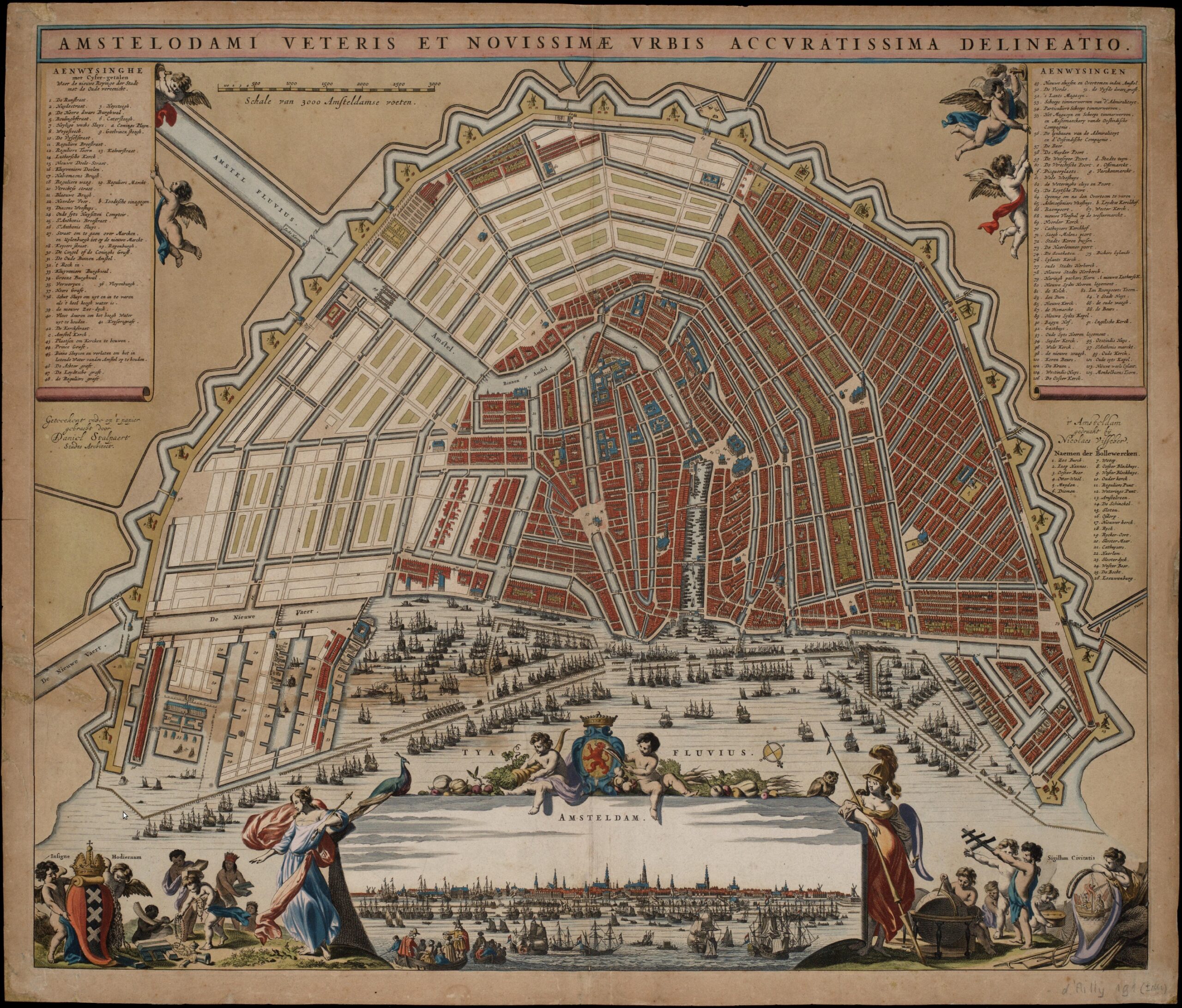
Stalpaert’s best-known work is a showpiece map of Amsterdam with its “new enlargement”, an etching in six sheets measuring about 140 by 163 centimetres. He obtained a privilege to publish it from the States General on 11 July 1662 and from the States of Holland on 27 November 1662. He had to deliver 42 coloured copies to the city, one for each member of the council plus a few for the burgomasters to give away. He was paid 100 ducatons for his extra trouble in staking out the streets and canals, on condition that he supply fifty uncoloured copies at his own expense, and later 315 guilders towards his costs. A further reward that he asked for was refused.
On the map itself, Stalpaert credits the design of the extension to the gentlemen of the committee, among them Schaep, De Graeff, Witsen, Blaeu and Hasselaer. Van Essen points out that these were also his employers. The map shows the existing city and the planned extension side by side, with the new district laid out as streets, canals, plots and bridges before anything was built. That is why the bridge posts can say a crossing appears on it while the land around it is still empty. This site’s post on Stalpaert’s 1662 map sits in the series on historic maps of Amsterdam, between the 1657 Van Berckenrode map and Jacob Bosch’s map of around 1679, which shows how much of the plan had been built.
What He Designed
Stalpaert left a modest body of work, and some attributions are still disputed. No signed drawing by him survives, and for most city buildings the council records do not say who was asked for the design. Van Essen lists the cases where his name does appear with a payment or a commission: the storehouses and yards of the VOC and the Admiralty, the churches of ‘s-Graveland and Oudshoorn, the Oosterkerk, an orphanage and bakery for the deacons, the Prinsenhof, the Leidsepoort and “the bridge over the Amstel”. For the extension itself, the designs she treats as certain are the Leidsepoort, the bridge over the Amstel, the Ossenmarkt with its buildings, and the city masons’ yard with an official residence.
The building most often cited is ‘s Lands Zeemagazijn, the Admiralty storehouse on Kattenburg, begun on 28 September 1655 and finished within about nine months. It burned in 1791 and was rebuilt by the later city architect Abraham van der Hart, and today it houses the national maritime museum, Het Scheepvaartmuseum. The VOC’s own storehouse on Oostenburg, the Oost-Indisch Zeemagazijn of 1665, was also his design; it collapsed on 14 April 1822. The post on the Paerlduiker, bridge 91, covers the islands where both stood.

In the canal ring, his surviving building is the Amstelkerk on the Amstelveld, built between 1668 and 1670 as a temporary wooden preaching barn, with the square left large enough for a stone church that was never built. It is a rijksmonument, and it stands beside bridges 72 and 73 where the Prinsengracht crosses the Reguliersgracht. Stalpaert became the first of its four churchwardens in 1669. The Oosterkerk of 1669 to 1671 is recorded on Dutch Wikipedia as Adriaen Dortsman’s design with Stalpaert’s participation; the treasurers approved a design by Stalpaert on 4 July 1669, but Dortsman was paid “on account of the architecture” in 1672, and the finished church looks more like his work. The plain Leidsepoort, built in 1664 where the American Hotel now stands and demolished in 1862, was the extension’s main gate to the south-west.

In 1669 he built himself a large house seven bays wide across three lots on the Keizersgracht, with three coach houses behind it on the Kerkstraat. The only known picture of it is on Jacob Bosch’s bird’s-eye map of the extension.
Which Bridges Are His
On the evidence of the sources consulted here, none of the numbered bridges covered on this site can be attributed to Stalpaert as designer. Three points explain why.
First, drawing a bridge on a plan is not designing it. When a post says Stalpaert “drew” a bridge in 1662, it means the crossing was part of the layout of the extension. The map records where a bridge was to go. It says nothing about who drew the structure, and the bridges on those sites today are later rebuilds.
Second, the city’s bridges were the business of other masters. Van Essen finds that Swanenburgh, the city carpenter, made the designs for the Muiderpoort, the Weesperpoort and the Utrechtsepoort, and for “the bridges for all four of the new gates”, which includes the bridge in front of Stalpaert’s own Leidsepoort. The ordinary upkeep of bridges fell to the city boatbuilder, whose forty men in 1666 included four who tarred the bridges. A budget from that year counted 95 stone bridges, 55 wooden bridges with stone abutments, 77 wooden bridges and 18 stone sluices inside the city, all maintained by these crafts rather than by the city architect, whose salary was not even part of the works budget.
Third, the one bridge Van Essen does attribute to him, “the bridge over the Amstel”, is not identified in her article. In those years the great new crossing of the river was the Hoge Sluis, completed in 1662 as a stone bridge about 220 metres long on 35 arches, carrying the line of the new wall across the Amstel. Willem Springer’s bridge of 1883, rebuilt between 2009 and 2012, now stands in its place. The plan also included a broad stone bridge at the end of the Kerkstraat, which was never built in that form: after the disaster year the city put up a cheaper, narrower wooden bridge there around 1691, designed by the city carpenter Hans Jansz van Petersom. That crossing became the Magere Brug. Either could be the bridge in the records. The sources consulted here do not say which.
Two groups of posts touch on Stalpaert in more specific ways. Where the Utrechtsestraat crosses the canals, his map marks “inner sluices and locks to hold back the water let in from the Amstel”, and the posts on bridge 34, bridge 37 and bridge 75 follow those sluices into the present. The annotation is his; the engineering is not attributed to him. At the Leidsegracht, the Steenhouwerijbrug, bridge 45, takes its name, according to Dutch Wikipedia, from the city masons’ yard that lay beside it while the district was laid out. The council decided on 21 December 1663 to create that yard on new ground on the Lijnbaansgracht north of the Leidsegracht, and two months later Stalpaert was commissioned to design it, with a residence. The bridge is not his, but its name points at one of his documented works.
For the rest, the map is the link. The Leidsegracht crossings at bridge 28, bridge 44, bridge 46, bridge 93 and bridge 94 sit on the seam between the old city and the new, and the Keizersgracht bridges at the Vijzelstraat, the Spiegelstraat and the Leidsestraat, 41, 42 and 43, were planned on empty land. On the Lijnbaansgracht, the outer edge of the extension, bridge 81, bridge 88 and bridge 89 all appear on the 1662 plan. In every case the sentence to trust is the modest one: the crossing was part of the plan in 1662.
The Last Years
From 1666 the city contracted out new works, and the city masters had to write their own specifications. Stalpaert shared the specifications for the digging, dredging and refuse works with the overseer Jan Hendricksz van den Bergh. He also surveyed and valued land, and in 1670 his salary was raised to 1,800 guilders for his many extraordinary services, “in surveying and otherwise”. In May 1672, with the works of architecture “now mostly coming to an end”, he was asked to take over the duties of the late city surveyor without extra pay. Two weeks later the city appointed Jacob Bosch as city engineer and surveyor, and Stalpaert turned to the defence works the war required.
He died in 1676 at the age of 61 and was buried on 3 December in the Nieuwezijds Kapel, in the grave of his father-in-law. The council decided the post of architect was no longer needed and would remain abolished. No will is known, and his drawings and books have not been traced.
Reading “Stalpaert” on This Site
Some older pages on this site make larger claims for Stalpaert than the records support. He was the city’s first architect, and his map is the classic image of the fourth extension, but the plan was the work of a committee and several city officials, the fortifications owe much to Coeck, and the bridges that the records assign to anyone were the city carpenter’s, with their upkeep left to the boatbuilder’s crew. No source consulted here supports the claim that he designed the Blauwbrug or a set of stone bridges over the Amstel; the Blauwbrug stands where a wooden drawbridge led to the island of Vlooienburg, laid out from 1595 and part of the city long before the fourth extension. When an entry says a bridge appears on Stalpaert’s map, read it as a date for the crossing, not a name for its designer.
Every bridge documented so far is listed in the bridge index, by number, by name and by canal.
Sources Consulted
- Gea van Essen, “Daniel Stalpaert (1615-1676), stadsarchitect van Amsterdam en de Amsterdamse stadsfabriek in de periode 1647 tot 1676”, Bulletin KNOB 99 (2000), pp. 101 to 121
- Daniël Stalpaert, Nederlandstalige Wikipedia
- Uitleg van Amsterdam in de 17e eeuw, Nederlandstalige Wikipedia
- Grachtengordel (Amsterdam), Nederlandstalige Wikipedia
- ‘s Lands Zeemagazijn, Nederlandstalige Wikipedia
- Amstelkerk (Amsterdam), Nederlandstalige Wikipedia
- Oosterkerk (Amsterdam), Nederlandstalige Wikipedia
- Leidsepoort, Nederlandstalige Wikipedia
- Hogesluis, Nederlandstalige Wikipedia
- Magere Brug, Nederlandstalige Wikipedia
- Steenhouwerijbrug, Nederlandstalige Wikipedia
- Brug 37, Nederlandstalige Wikipedia
- Plantage (Amsterdam), Nederlandstalige Wikipedia
- Rijksmonumentenregister, monument 269: Amstelkerk, Amstelveld 2
- Bureau Monumenten & Archeologie Amsterdam, “Daniël Stalpaert (1615-1676)” (archived copy)
- Featured image: map of Amsterdam with the fourth extension, Daniël Stalpaert, 1662, edition published by Nicolaes Visscher, via Wikimedia Commons, public domain