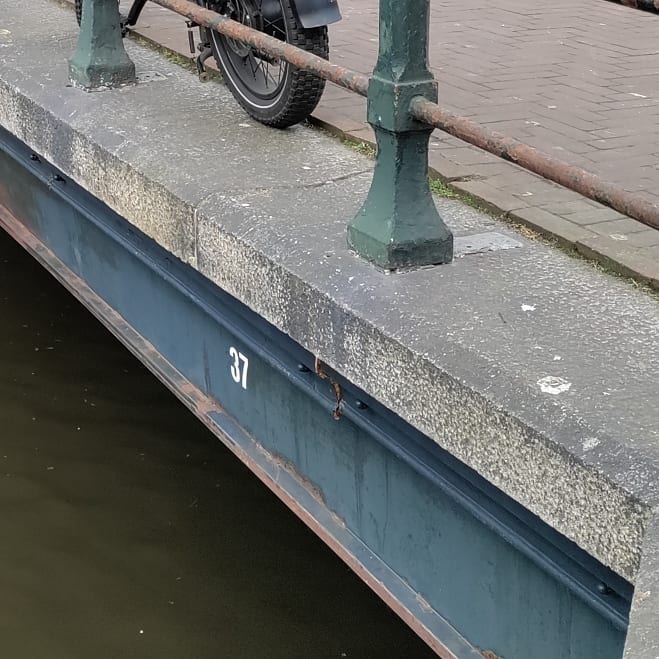
A Utilitarian Road Bridge on the Utrechtsestraat at the Keizersgracht, and the Memory of a Lost Hydraulic Function
Bridge 37 carries no official name and never has. It sits in the Utrechtsestraat, carries tram line 4 as it has since 1948, and spans the Keizersgracht at the second-to-last crossing before that great canal flows into the Amstel. Seen from the street, it is the most unremarkable bridge in the Utrechtsestraat sequence. Seen from the air, however, it is something more interesting: a road bridge whose outline still reveals the sluice it once was, a narrowing of the Keizersgracht east of the crossing that is the physical remnant of a hydraulic structure that Daniël Stalpaert described, in his 1662 city plan, as a “Binne sluis en verlaten om het in latende water vanden Amstel op te houden.” An inner sluice and lock to hold back the incoming water of the Amstel. The function has gone. The shape in the canal bed remains.
1. Etymology and Naming: The Peylsluis, an Abolished Informal Name, and What It Remembered
Until 5 July 2016, this bridge was unofficially known as the Peylsluis, named after the four peylsluizen or verlaten (inner sluices or gauge locks) that once stood in the Utrechtsestraat. Since that date, the informal name has been abolished.
The word “peylsluis” requires unpacking, because it describes something very specific in the hydraulic engineering of 17th-century Amsterdam. On Jacob Bosch’s map with the Fourth Expansion of around 1679, a sluis is drawn here. That inner sluice was known as a peylsluis. Similar sluices also existed in the Herengracht and the Prinsengracht. City architect Daniël Stalpaert had already drawn those sluices in the design section of his map of 1662, when it was still predominantly empty land at the Utrechtse straet and Keisers Graft. He noted alongside them that these were “Binne sluysen en verlaten om het in latende water vanden Amstel op te houden.”
Stalpaert’s Dutch is precise. “Binne sluysen en verlaten” means inner sluices and locks. “Om het in latende water vanden Amstel op te houden” means to hold back the water admitted from the Amstel. The peylsluis, or gauge lock, was therefore a hydraulic control structure whose purpose was to regulate the level of water entering the canal ring from the Amstel. The construction of sluices in Amsterdam made it possible to better regulate water levels in the canals. Clean water was taken in from the lake IJ at high tides, and dirty city water was drained at low tide. The Utrechtsestraat sluices, of which Bridge 37’s predecessor was one of four, were part of this system of inner water management, controlling the flow of Amstel water into the canal belt at points along the radial streets.
The “peyl” element of the name refers to measurement or gauging. A peylsluis was not merely a lock but a water-level monitoring and control point, part of the sophisticated hydraulic governance that allowed Amsterdam to maintain its canals at a consistent depth despite the tidal pressure of the Amstel and the IJ. The canals of Amsterdam were not simply dug and left. Locks, sluices, and pumping stations actively managed water levels throughout the canal belt, a system that required constant maintenance and monitoring.
The abolition of the name Peylsluis in 2016 followed Amsterdam’s city-wide policy on unofficial bridge names. As with the Casar Philipssluis (the former informal name of Bridge 35) and the Vingboonsbrug (the former name of Bridge 26), the Peylsluis name was historically well-grounded but had never been formally adopted. It has now been replaced by nothing: Bridge 37 simply bears its number.
2. Structural Evolution: From Stalpaert’s Gauge Lock of 1662 to a Surviving Structure in 2009
The structural genealogy of Bridge 37 begins with the same documents that underlie Bridge 34 and Bridge 35: Stalpaert’s 1662 city map, Jacob Bosch’s Fourth Expansion map of around 1679, and the subsequent sequence of replacements driven by the demands of modern traffic.
There has been a structure here for centuries. On Jacob Bosch’s map with the Fourth Expansion of around 1679, a sluis is drawn here. Stalpaert had already drawn the sluices in the design section of his 1662 map. The sluice shown on both maps was a functioning hydraulic structure, not merely a road crossing: it controlled water levels between the Amstel-influenced eastern section of the Keizersgracht and the more stable western section, as part of the inner sluice system described by Stalpaert.
The transition from hydraulic sluice to road bridge occurred in stages as the canal belt was modernised across the 18th and 19th centuries. The peylsluizen in the Utrechtsestraat gradually lost their water management function as Amsterdam’s canal system was reorganised and the hydraulic control points were moved to more effective locations. By the time tram line 4 first crossed the bridge in 1948, it was a road bridge carrying a tram, not a water regulation structure.
The most revealing document in the bridge’s modern history is the decision taken in 2009. In 2009 there were plans to drastically renew the bridge as part of the general adaptation of the Utrechtsestraat as a traffic artery: reprofiling, adapting to modern requirements, new tram rails, and so on. However, after the debacle at Bridge 34, where a disagreement about the safety of the renewed bridge caused an enormous delay in the project, it was assessed whether Bridge 37 had better withstood the test of time. It was estimated that Bridge 37 could hold out for a while longer, and so the bridge was not renewed.
The debacle at Bridge 34, detailed in the Bridge 34 post in this series, therefore had a direct and positive consequence for Bridge 37: it saved the older bridge from replacement. The dispute over asphalt thickness and clearance height that halted work on Bridge 34 for over a year made the municipality cautious about repeating the same process on Bridge 37, and the structural assessment confirmed that the caution was justified.
Seen from the air, the bridge still has the form of a sluice. To the east of the bridge, the canal narrows, and on the widened quay that results from this narrowing there once stood a sluice keeper’s house, which in later years became a flower stall. Since the bridge is still relatively low, the placement of houseboats on the Keizersgracht is only possible to the east of the bridge.
This last detail is one of the most practically significant in the entire series: the relatively low clearance height of Bridge 37 acts as a practical boundary within the Keizersgracht itself, defining where houseboats can and cannot moor. The bridge’s hydraulic inheritance, in other words, has become a spatial regulation, still shaping how people use the canal today.
3. Architectural Lineage: Publieke Werken, No Amsterdam School Attribution, and a Bridge That Still Reveals Its Past
No individual architect is confirmed for Bridge 37 in any source consulted for this post, and the bridge is attributed to the Dienst der Publieke Werken in the municipal records without further specification. The traffic bridge, over which tram line 4 has been running since 1948, is located in the Utrechtsestraat and spans the Keizersgracht. It is the second-to-last bridge before the Keizersgracht flows into the Amstel at the Lucas Jansz. Sinckbrug. The bridge is itself not a monument, but is surrounded by municipal and national monuments.
The bridge carries no Amsterdam School design elements: no custom ironwork by Kramer, no Hildo Krop sculptures, no granite nose stones. It is a plain utilitarian crossing, built to carry trams and traffic, and it looks exactly as described. What it does carry, in its aerial outline and in the narrowed canal east of its deck, is something no amount of decorative ironwork can provide: the memory of a function. The shape of the peylsluis is still legible in the landscape, more than three and a half centuries after Stalpaert first drew it.
The Dienst der Publieke Werken believed in the idea of the Gesamtkunstwerk, in which engineers, architects, and artists worked together on a project. From 1916, under Allard Hulshoff, the department built in a consistent style: a carefully detailed form of the Amsterdam School. In 1916, Hildo Krop was appointed as city sculptor. Bridge 37 predates or sits outside that period of decorative ambition at Publieke Werken, and represents the department’s more functional, anonymous tradition.
4. Urban and Social Context: Tram 4, the Second-to-Last Crossing, and the Keizersgracht as a Skating Canal
Bridge 37 occupies a position in the Keizersgracht sequence that mirrors Bridge 34’s position in the Herengracht sequence: second from last before the canal reaches the Amstel, carrying the same tram line, unmarked by any official name. The parallels between the two bridges are striking and deliberate: both are products of the same Utrechtsestraat traffic artery, both carry tram line 4, both sit in the shadow of larger and more celebrated bridges on either side.
The Keizersgracht is spanned by 14 bridges, all fixed. At Keizersgracht 764 and 709 is the intersection with Utrechtsestraat, which is where Bridge 37 is located. The Keizersgracht is designated as the main canal for skating when ice forms in winter. If ice forms, Waternet will stop circulation of water in the canals by closing the locks, and boats will be prohibited from sailing on a number of canals, including the Keizersgracht. The fact that the Keizersgracht is the designated skating canal is itself a function of its width: at 28.3 metres, it is the widest canal in Amsterdam’s inner city, and it offers the best continuous skating surface when frozen. Bridge 37, low-slung as it is, becomes a threshold on those rare winter mornings when the ice is thick enough: skaters can pass under it, but the clearance is not generous.
The Museum Van Loon at Keizersgracht 672 is a ten-minute walk along the canal from Bridge 37. A total of 14 bridges span the Keizersgracht, of which the Lucas Jansz. Sinckbrug at the junction with the River Amstel is the oldest and most picturesque. From Museum Van Loon it is only a brief walk to the Lucas Jansz. Sinckbrug that marks the end of the canal. The Utrechtsestraat itself is one of Amsterdam’s most characterful independent shopping streets, and the bridge sits at the point where that street crosses from the southern canal houses into the final residential stretch before the Rembrandtplein.
5. Technical Specifications
Based on confirmed sources, the following can be stated:
- Bridge type: Fixed road bridge (vaste verkeersbrug); the form of the original sluice structure is still visible from the air in the narrowed canal section east of the bridge
- Location: Utrechtsestraat over the Keizersgracht, Amsterdam-Centrum
- Canal: Keizersgracht (dug from 1615; widest canal in Amsterdam’s inner city at 28.3 metres; UNESCO World Heritage Canal Belt, listed 2010)
- Position on the Keizersgracht: Second-to-last bridge, immediately before Bridge 36 (Lucas Jansz. Sinckbrug) at the Amstel
- Tram: Line 4 (since 1948)
- Cartographic record: Daniël Stalpaert’s city plan, 1662 (drawn as “Binne sluysen en verlaten om het in latende water vanden Amstel op te houden,” an inner sluice and lock to hold back Amstel water); Jacob Bosch’s Fourth Expansion map, around 1679 (drawn as a peylsluis)
- Original function: Hydraulic gauge lock (peylsluis), one of four in the Utrechtsestraat, regulating water levels between the Amstel-influenced and the canal belt sections of the Keizersgracht
- Surviving physical evidence of sluice origin: Narrowing of the canal east of the bridge; widened quay on which the sluice keeper’s house (later a flower stall) once stood; aerial view of the bridge still reveals the sluice form
- Clearance height: Relatively low by Amsterdam standards; houseboats on the Keizersgracht can only moor to the east of the bridge
- 2009 assessment: Assessed as structurally sound for continued use following the Bridge 34 debacle; not renewed as planned
- Designer: Dienst der Publieke Werken; no individual architect confirmed
- Amsterdam School attribution: None
- Monument status: Not a monument (geen monument); surrounded by gemeentelijke and rijksmonumenten
- Former informal name: Peylsluis; abolished 5 July 2016 under Amsterdam’s policy on unofficial bridge names
- Current official name: None; designated in the municipal register as Brug 37
Sources Consulted
- Bruggenvanamsterdam.nl, bridge register entry for Brug 37
- Wikipedia (nl), “Brug 37”
- Wikipedia (en), “Keizersgracht”
- Wikipedia (nl), “Keizersgracht (Amsterdam)”
- Amsterdam op de kaart, “Keizersgracht, 1850 to 1940”
- Amsterdam op de kaart, “Publieke Werken”
- MDPI, “Retrospective Analysis of Water Management in Amsterdam, The Netherlands,” Peters et al., 2021
- Hotels.com Go Guides, “Keizersgracht in Amsterdam”
- Wikimedia Commons, Category: Brug 37 (Amsterdam)
- Frank V. Smit, “Bruggen in Amsterdam,” 2008, Uitgeverij Matrijs (cited in Wikipedia nl, “Brug 37”)
Public Domain Images
1. Wikimedia Commons: “Brug 37 Amsterdam” category photographs The Wikimedia Commons category for Bridge 37 holds contemporary photographs of the bridge in its current form, showing the Utrechtsestraat crossing and the Keizersgracht on both sides of the deck. Available under free licences. URL: https://commons.wikimedia.org/wiki/Category:Brug_37_(Amsterdam) Attribution: “Wikimedia Commons, Category: Brug 37 (Amsterdam). Available under the licences specified on individual file description pages.”
2. Stadsarchief Amsterdam Beeldbank: “Keizersgracht bij de Utrechtsestraat” historical photographs The Stadsarchief Amsterdam Beeldbank holds historical photographs of the Keizersgracht at the Utrechtsestraat crossing, including images from the late 19th and early 20th centuries showing the bridge in its earlier form before tram line 4 was introduced in 1948. Searchable via the Beeldbank at archief.amsterdam under “Keizersgracht Utrechtsestraat” or “brug 37.” URL: https://archief.amsterdam/beeldbank Attribution: “Collectie Stadsarchief Amsterdam. Available for non-commercial use with attribution.”
3. Daniël Stalpaert, “Plattegrond van Amsterdam,” 1662, Stadsarchief Amsterdam / Rijksmuseum Stalpaert’s city map of 1662 is the primary source document for the original peylsluis at this location, described in his own annotation as “Binne sluysen en verlaten om het in latende water vanden Amstel op te houden.” The map is held in both the Stadsarchief Amsterdam and the Rijksmuseum, and is fully in the public domain as a work from 1662. It shows the Utrechtsestraat sluice system in its planned state, predating the construction of the surrounding canal houses. URL: https://archief.amsterdam/beeldbank (search: “Stalpaert plattegrond 1662”) Attribution: “Daniël Stalpaert, Plattegrond van Amsterdam, 1662. Collectie Stadsarchief Amsterdam / Rijksmuseum Amsterdam. Public domain.”
Bridge 37 Unnamed. Brug zevenendertig.
Similar to #brug34 right down to the history of the bridge which is roughly the same as that of bridge 34 (in the Utrechtsestraat over the Herengracht), because this bridge is an extension of Utrechtsestraat. It therefore also had to be widened to create the possibility for a tram stop across the bridge (presumably eighties of the 19th century). In addition, the bridge was also possibly widened to fit into a widening of the Utrechtsestraat until that plan fell through in favour of the Vijzelstraat.


Map and location of Bridge 37 (Unnamed)
This road bridge is located in the Utrechtsestraat and crosses the Keizersgracht it’s the next bridge along Utrechtsestraat from Brug 34. Tram line 4 has been running over this and bridge 34 since 1948. The bridge is unnamed and not a monument.


Information and history of Bridge 37 (Unnamed)
The history of the bridge is basically the same as that of bridge 34 (also on the Utrechtsestraat over the Herengracht). It therefore also had to be widened to create the possibility for a tram stop across the bridge.
Also this bridge seems wider than usual due to the unfinished plan to make Utrechtsestraat the radial road.
Seen from the air you can see the bridge still has the shape of a lock. To the east of the bridge the canal narrows and the quays widen and the old lockkeeper’s house, which later became a flower shed.
Picture 1
Bridge 37 in 1897 by Jacob Olie with already split track on the bridge
