Throughout this project I’ve been researching each bridge to determine when it was built as well as it’s location. Of course this means that much of the time looking at old maps of Amsterdam.
Also of course living near to het Scheepvaartmuseum (The national maritime museum) helps as they have lots of old maps there (and of course wikipedia has a ton of information too about the people who painted the original maps like Cornelis Anthonisz. and the maps themselves. Also the University van Amsterdam (UvA) has a lot of digitised versions and a history of the maps from the 16th century onwards.
The oldest map in the dates from 1538. It is the woodcut “birds-eye view” map by Cornelis Anthonisz. and it is the first printed map of Amsterdam. Not all rare maps of Amsterdam from this period are available. Luckily however there were many reproductions of older maps.
The Renaissance Origins (1538 to 1600)
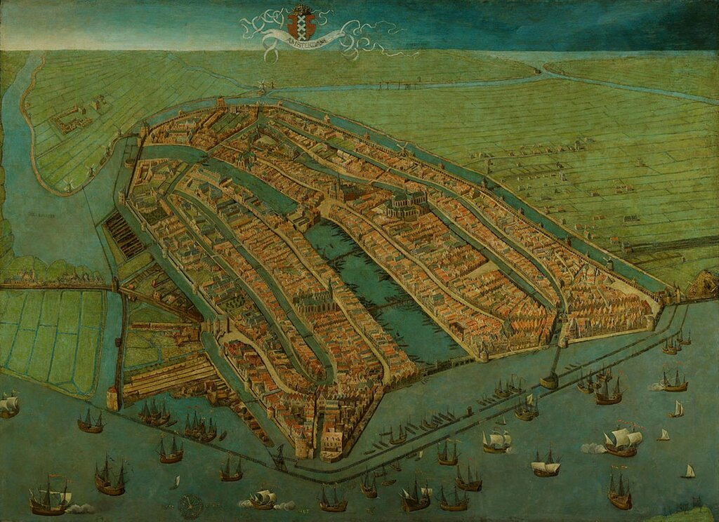
Witness the Birth of a Metropolis: The 1538 Anthonisz. Map
Before the grand canals and the Golden Age, there was the Amsterdam of 1538. Discover the oldest surviving map of the city, a stunning oil painting that captures the medieval heart of the Dutch capital. From its original wooden fortifications to the early shipping trade on the Amstel, this rare birds-eye view by Cornelis Anthonisz. is the ultimate starting point for anyone interested in the evolution of Amsterdam. See where the story began and how the city’s layout has remained surprisingly recognizable for nearly five centuries.
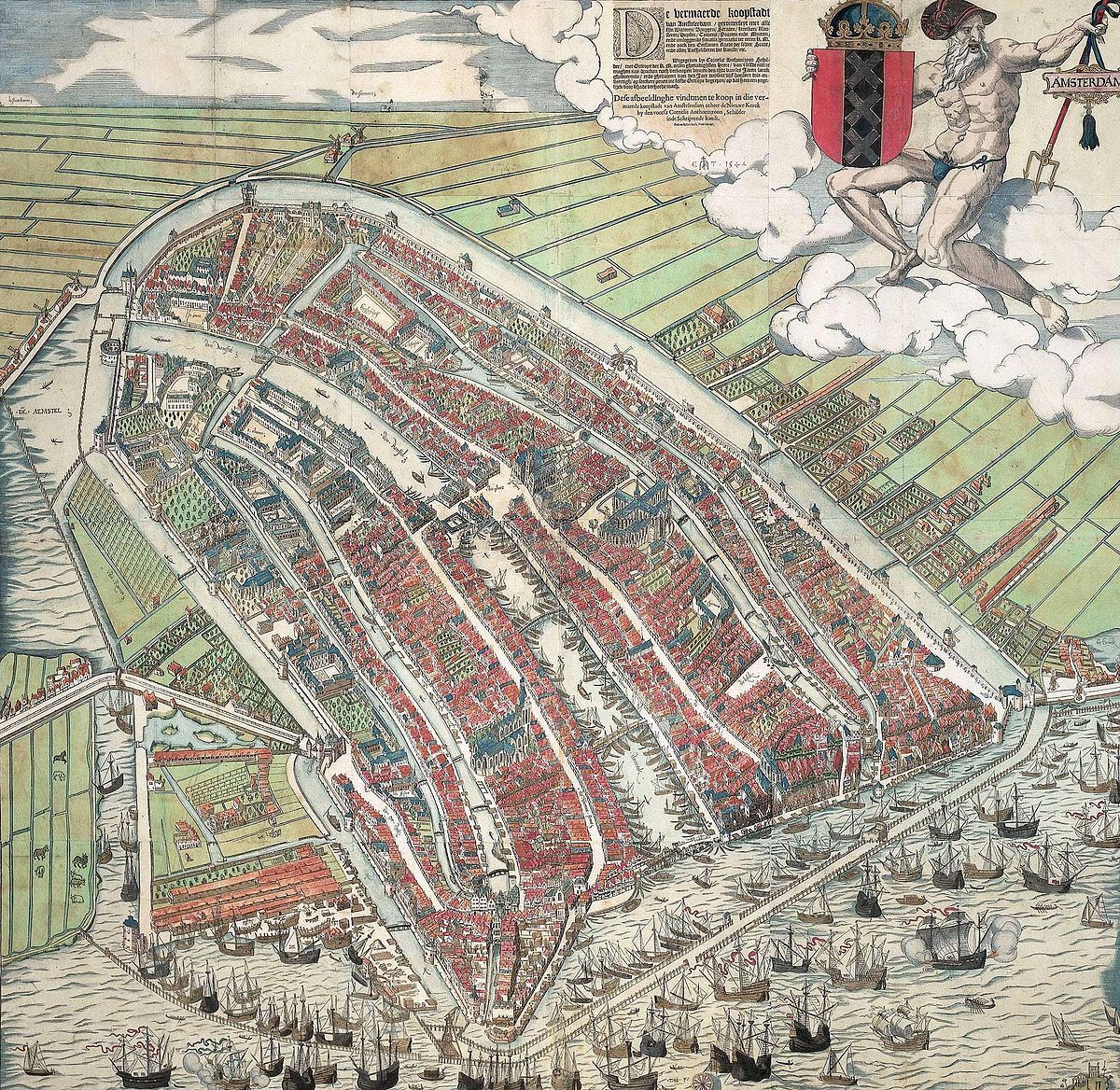
Step Into the 16th Century with the 1544 Colored Woodcut
Experience Amsterdam as it was first shared with the world. The 1544 woodcut by Cornelis Anthonisz. is the very first printed map of the city, offering a spectacular birds-eye view of a bustling medieval port. In its rare hand-colored form, this map vividly illustrates the red-roofed houses and Gothic spires that defined the city’s early skyline. See the roots of the Dutch capital before the Golden Age transformed its borders, and discover the artistry that made Amsterdam a star of Renaissance cartography.
In this 1544 woodcut, you can clearly see the early wooden defenses at the mouth of the Amstel, near where the oldest city bridges once stood.
Read more about the 1544 woodcut by Cornelis Anthonisz.

Explore the City on the Brink: Pieter Bast’s 1599 Masterpiece
Next came Pieter Bast in 1599 with his 4 part map of Amsterdam
Just as Amsterdam was about to explode into the most prosperous city on Earth, Pieter Bast captured its likeness in unprecedented detail. His 1599 four-part map was a technological marvel of its time, using fine copperplate engraving to show a city bustling with new maritime energy. Witness the medieval walls one last time before the great canal expansions of the 1600s, and see the ships that laid the foundation for the Dutch East India Company. It is a stunning visual record of a city standing on the threshold of history.
Bast’s 1599 map captures the city just as it began expanding east; notice the early bridge structures near the Sint Antoniesluis, which were vital for the city’s shipyard workers.
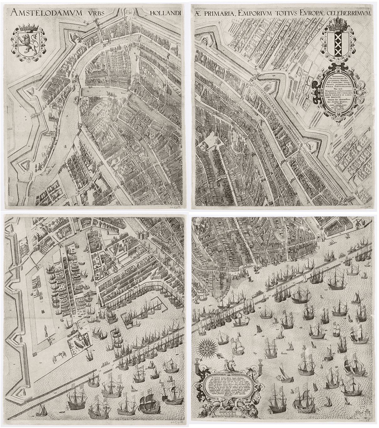
Read more about Pieter Bast’s 1599 Masterpiece
The Golden Age Masterpieces (1600 to 1700)
Behold the Canal Belt in Progress: The 1625 Van Berckenrode Plan
Step into the year 1625 and witness Amsterdam’s transformation firsthand. Balthasar Florisz. van Berckenrode’s legendary nine-sheet map offers an incredible three-dimensional look at a city in the midst of its greatest expansion. See the iconic Herengracht and Keizersgracht as they were first being carved into the landscape, and explore the bustling harbor that powered the Dutch Golden Age. This is the definitive “portrait” of a city reinventing itself as the center of the global economy, rendered with a level of detail that remains breathtaking four centuries later.
This 1625 plan provides a rare look at the very first stone bridges spanning the Herengracht, many of which laid the architectural foundation for the monumental bridges we see today.
Read more about The 1625 Van Berckenrode Plan
Behold the “Theatre of Cities” with Joan Blaeu’s 1649 Map
Discover the map that defined Amsterdam for the 17th-century world. Created by the legendary Joan Blaeu, this 1649 plan is a masterpiece of symmetry and status, capturing the Dutch capital at the peak of its global influence. From the precisely engraved canal arcs to the ornate allegorical flourishes, see why this map became the gold standard for urban cartography during the Dutch Golden Age. Explore the blueprint of a city that had truly become the “warehouse of the world.”
Blaeu’s precision allows us to identify the humble, functional bridges of the Jordaan, contrasting sharply with the grander crossings being planned for the elite canal belt.
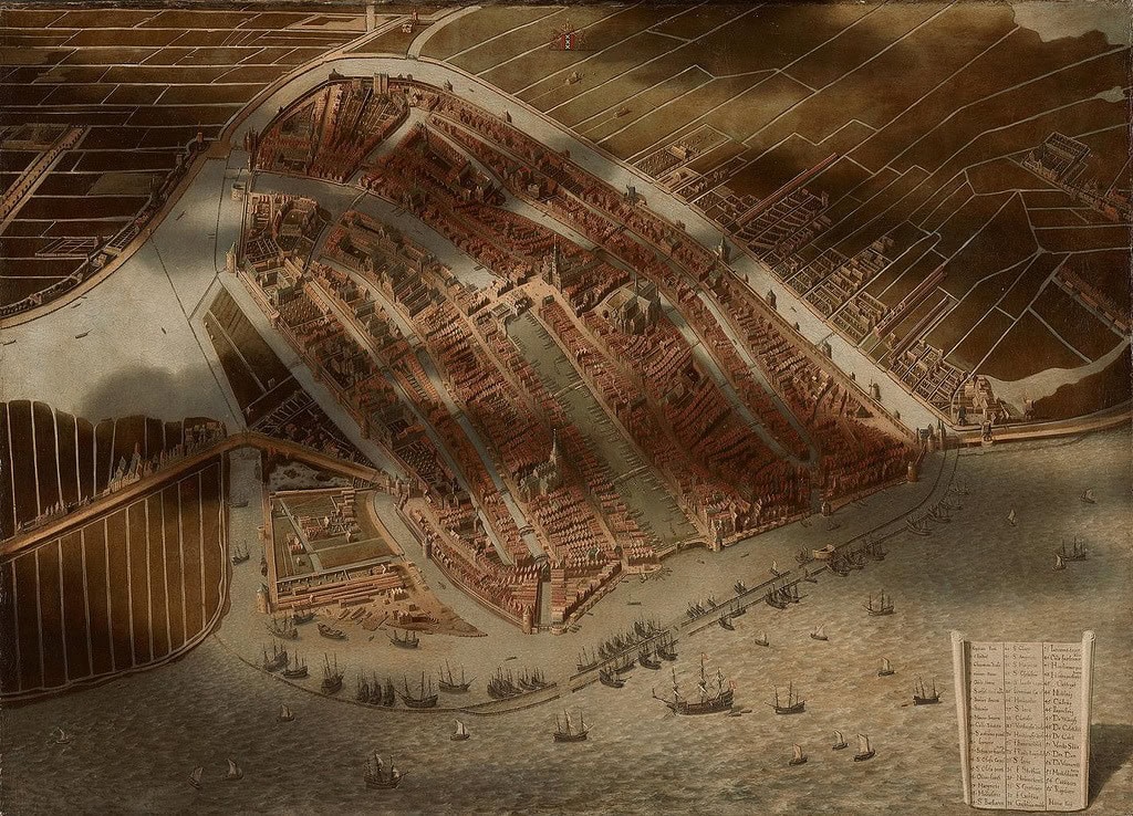
See the City Through the Clouds: Jan Micker’s 1652 Masterpiece
Experience a unique blend of history and art with Jan Micker’s stunning 1652 painting. Unlike traditional maps, this work uses dramatic light and cloud shadows to recreate Amsterdam as it looked in the mid-1500s. It is a breathtaking look at how Golden Age artists viewed their city’s history, turning a 100-year-old map into a vibrant, living landscape. Discover the atmospheric beauty of this “nostalgic” bird’s-eye view and see the medieval city through the eyes of a 17th-century master.
While Micker paints a nostalgic view of the 1500s, looking at this area today highlights how the once-empty banks of the Amstel eventually became home to the iconic Magere Brug.
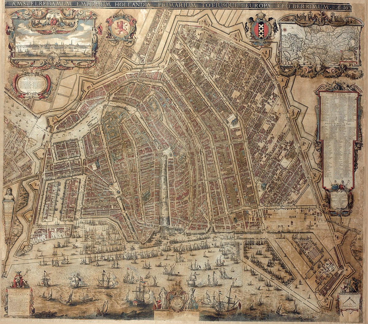
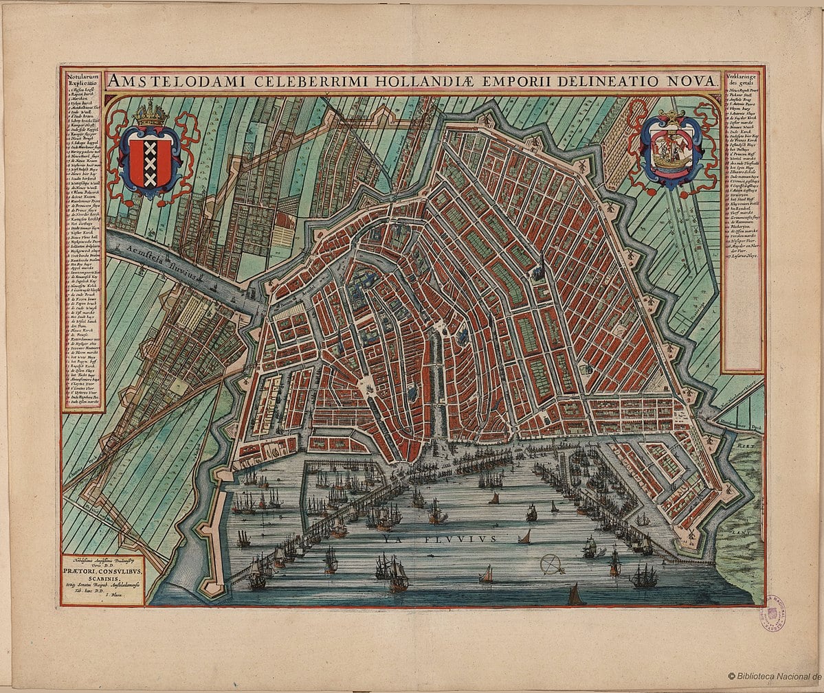
Witness the City in Full Bloom: The 1657 Van Berckenrode Map
Compare the Amsterdam of 1625 with the fully realized metropolis of 1657. In this updated masterpiece, Balthasar Florisz. van Berckenrode captures a city that has matured into a global powerhouse. From the completed merchant rows along the grand canals to the industrial pulse of the Jordaan, this nine-sheet wall map offers a breathtaking, three-dimensional look at the Golden Age at its zenith. Discover the evolution of the world’s most famous canal belt through the eyes of a master engraver.
By 1657, the map shows the completed bridges at the Leidsegracht, marking the boundary where the first phase of the Great Expansion met the second.
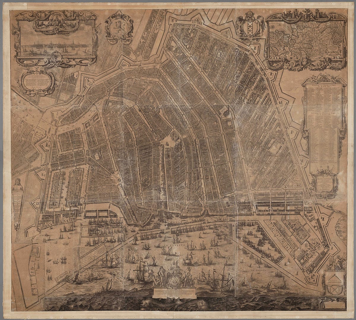
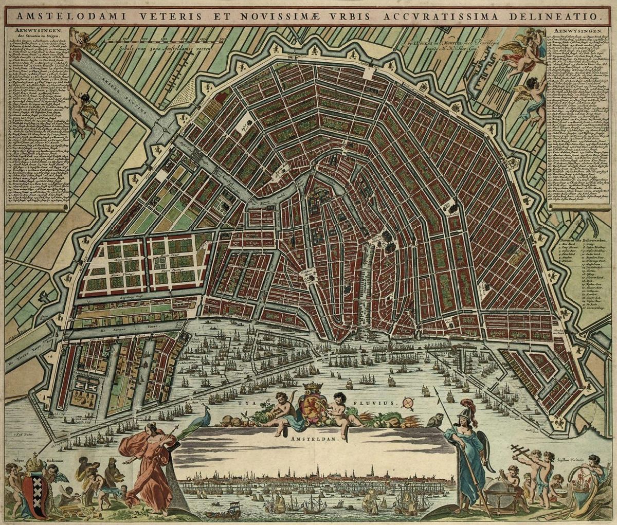
Step into the Architect’s Office: The 1662 Daniel Stalpaert Plan
Discover the map that built Amsterdam. As the city’s first official architect, Daniel Stalpaert created this 1662 masterpiece to serve as the blueprint for the city’s final, grand expansion. This fascinating plan reveals the transition from the old medieval core to the iconic, completed “Grachtengordel” we know today. Explore the technical precision and ambitious vision that turned a merchant port into a marvel of 17th-century engineering and urban design.
As City Architect, Stalpaert used this 1662 blueprint to plot the massive stone bridges required to cross the Amstel, including early designs for what would become the Blauwbrug.
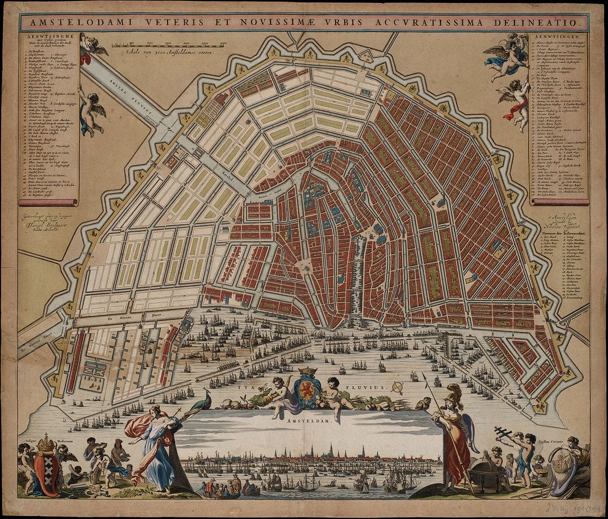
See the Vision Realized: The 1679 Jacob Bosch Map
Witness the moment Amsterdam’s ambitious “Great Expansion” finally came to life. The 1679 map by Jacob Bosch captures the city at its territorial peak, documenting the completed canal belt as it stretches beyond the Amstel River. From the formidable defensive bastions to the early greenery of the Plantage, this map offers a definitive look at the city’s Golden Age footprint. Discover the intricate details of a metropolis that had finally “filled out” its iconic horseshoe shape, creating the urban layout we still admire today.
Bosch’s map documents the finalization of the canal belt’s fourth expansion, including the strategic bridges connecting the new naval dockyards to the city center.

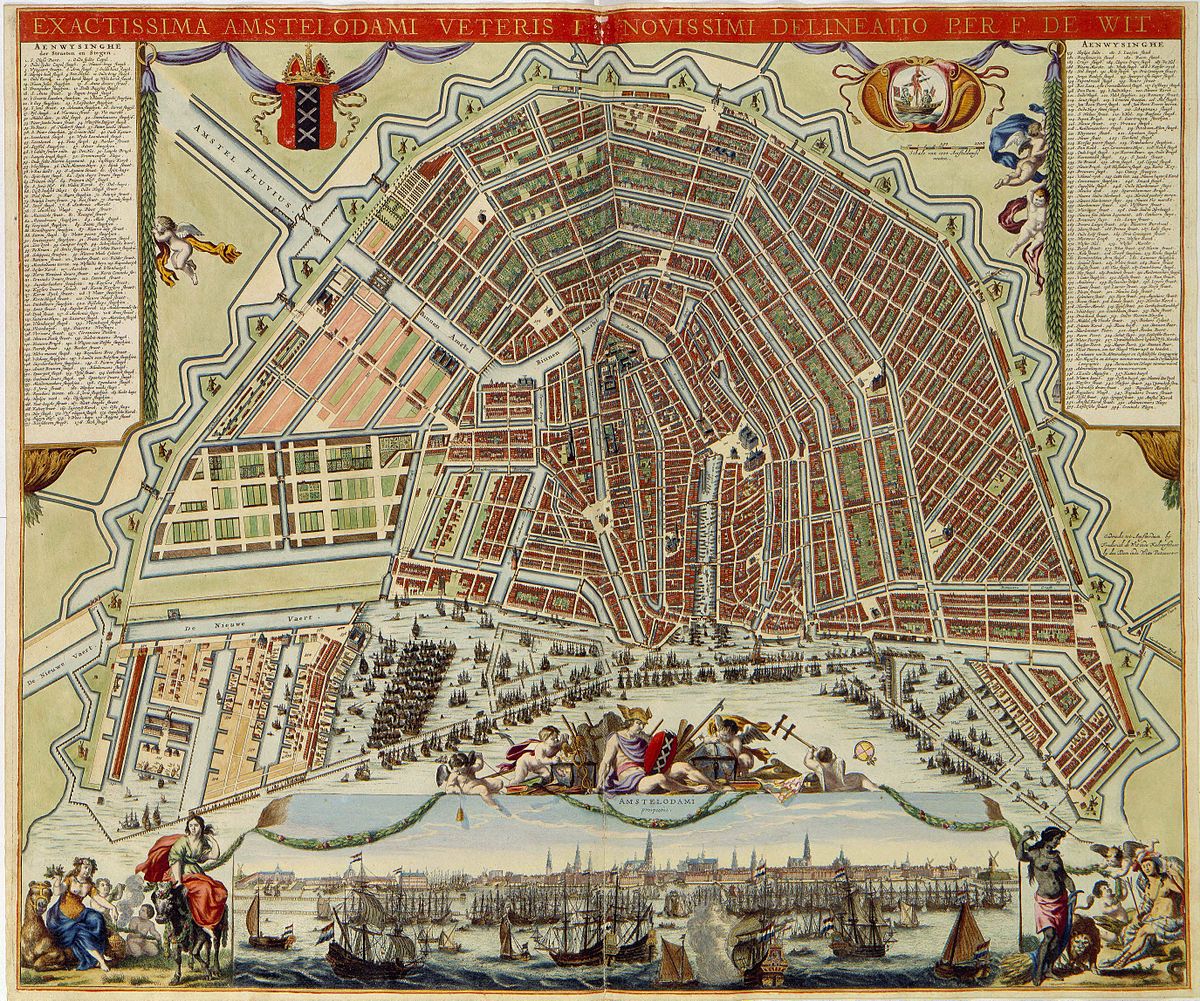
Witness the Golden Age in All Its Glory: The 1688 De Wit Map
Experience the absolute peak of Dutch cartographic art with Frederick de Wit’s 1688 masterpiece. This stunning plan offers more than just a street-level view; it includes a breathtaking panoramic profile of the 17th-century skyline as seen from the water. From the towering church spires to the hundreds of merchant ships in the harbor, see how De Wit captured the wealth, beauty, and precision of a city that had reached the height of its global power. It is the ultimate visual tribute to a completed Amsterdam.
De Wit’s aesthetic masterpiece captures the Reguliersgracht at its peak, the very canal famous today for the ‘Seven Bridges’ view seen in many of our historical galleries.
Enlightenment and Industrial Expansion (1700 to 1800)
Step into the Refined City: The 1721 Covens and Mortier Map
Discover Amsterdam at the dawn of the Enlightenment with this elegant 1721 plan. Produced by the legendary firm of Covens and Mortier, this map captures a city that has moved beyond the construction phase into a period of sophisticated maturity. With its clear typography and detailed index of landmarks, it offers a fascinating look at the fully settled Canal Belt and the bustling river life along the Amstel. See how the “Warehouse of the World” refined its urban landscape for a new century of global influence.
In the 1721 Covens and Mortier plan, we see the city’s infrastructure maturing, with older wooden bridges being replaced by the permanent stone arches that characterize the 18th-century style.”
Behold the “Warehouse of the World” in the 1737 De Broen Map
Take a step back into the most prosperous era of the 18th century with Gerrit de Broen’s 1737 masterpiece. This map goes beyond simple street names, offering a highly decorative and symbolic view of a city at the peak of its global influence. From the meticulously drawn windmills atop the city bastions to the elegant leisure gardens of the Plantage, the 1737 edition is a celebration of Amsterdam’s order, wealth, and beauty. Discover how this map served as both a practical guide and a powerful statement of Dutch civic pride.
De Broen’s map highlights the elegant bridges leading into the Plantage, reflecting the 18th-century shift toward using bridges as ornamental gateways to the city’s leisure parks.
Read more about Gerrit de Broen’s 1737 masterpiece

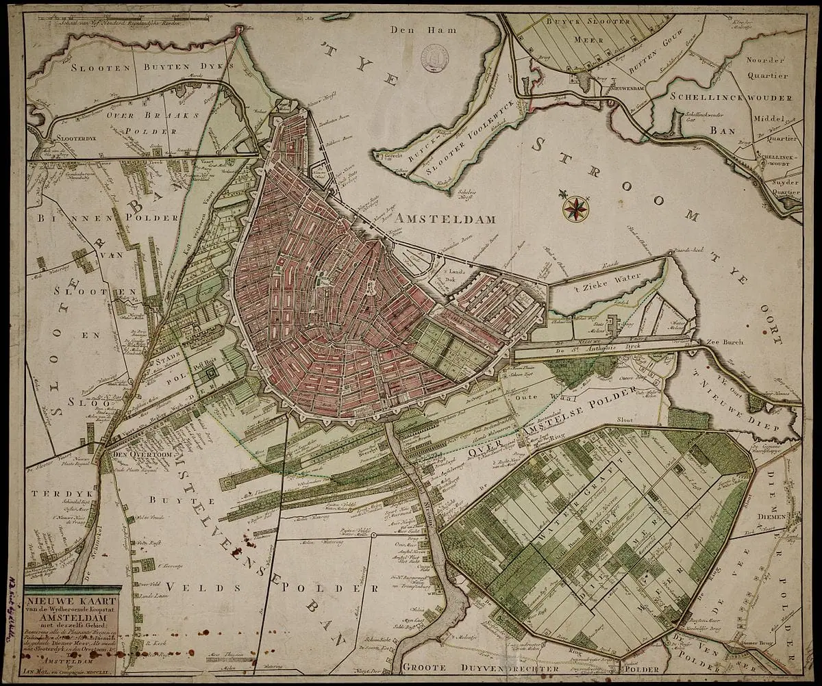
Step Outside the Singelgracht with the 1770 Jan Mol Map
Have you ever wondered what lay beyond the city’s defensive walls before the modern suburbs existed? The 1770 map by Jan Mol offers a rare, recreational view of Amsterdam, focusing on the windmills, footpaths, and elegant country estates that once dotted the surrounding polders. It is a fascinating look at the “leisure geography” of the 18th century, documenting the areas where Amsterdammers went to escape the bustle of the city. Explore the hidden paths and the famous “Hundred-Yards Line” that shaped the city’s rural outskirts.
Read more about the 1770 map by Jan Mol
Discover the Precision of the 1782 Gerrit de Broen Map
While early Renaissance woodcuts provided a charming “bird’s-eye” glimpse of a growing town, the 1782 map by Gerrit de Broen captures Amsterdam at its pre-industrial peak. This masterpiece of Enlightenment engraving offers an unparalleled look at the completed Canal Belt and the bustling naval shipyards of the Eastern Islands. It represents a shift from art to accuracy, documenting every bastion and bridge with a level of detail that served as the definitive record of the city for decades. Click here to explore the architectural elegance and urban planning of Amsterdam during this pivotal century.
Read more about the 1782 map by Gerrit de Broen.

Het Scheepvaartmuseum Cartography Exhibition
If you want to see these cartographic masterpieces in person, there is no better destination than the Het Scheepvaartmuseum (The National Maritime Museum) in Amsterdam. Housed in the majestic ‘s Lands Zeemagazijn—a former naval storehouse dating back to 1656—the museum itself is a monument to the very era these maps document.
The museum’s Cartography Exhibition is world-renowned, featuring one of the most significant collections of maritime charts and urban plans in existence. Here, you can move beyond digital screens and appreciate the true scale of nine-sheet wall maps or the vibrant, hand-applied colors of 16th-century woodcuts. The collection highlights how Amsterdam’s identity was inextricably linked to the sea, showcasing how the city’s meticulous urban planning was designed to support its status as a global trading hub.
From the early, imaginative “bird’s-eye” views of Cornelis Anthonisz. to the high-precision engravings of the Blaeu and De Broen eras, the museum provides the physical context for these works. Seeing them in the heart of the historic harbor district—just a short distance from the very canals and bastions they depict—offers a profound connection to the engineers and artists who mapped the Dutch Golden Age.
Visitor Information
- Location: Kattenburgerplein 1, Amsterdam.
- Key Highlight: The “Atlas Maior” by Joan Blaeu and various oversized wall maps of the city.
- Pro Tip: Check out the courtyard’s stunning glass roof, which is inspired by the compass lines on old nautical charts.

Frequently Asked Questions about Amsterdam’s Historic Maps
What is the oldest surviving map of Amsterdam?
The oldest surviving map is a 1538 bird’s-eye view painting by Cornelis Anthonisz. Unlike later printed woodcuts, this was an oil painting on wooden panels created for the Amsterdam Town Hall. It shows a medieval, fortified city centered around the Amstel River before the famous 17th-century expansions.
Who were the most famous mapmakers of the Dutch Golden Age?
Amsterdam was the world capital of cartography in the 17th century. The most prominent names include Joan Blaeu, famous for the Atlas Maior; Balthasar Florisz. van Berckenrode, known for his incredibly detailed 3D-style wall maps; and Frederick de Wit, whose 1688 map is considered the aesthetic peak of the era.
When was the famous “Canal Belt” first mapped?
While the 1544 and 1599 maps show the early city, the first “blueprint” for the iconic horseshoe-shaped Canal Belt (the Grachtengordel) appears in the early 1600s. The 1625 Van Berckenrode map shows the first three grand canals under construction, while the 1662 Daniel Stalpaert map serves as the official master plan for the final eastern expansion.
Where can I see these historic Amsterdam maps in person?
The best place to view these maps is Het Scheepvaartmuseum (The National Maritime Museum) in Amsterdam. They house one of the world’s most significant maritime and cartographic collections, including original works by Blaeu and Anthonisz. The Amsterdam Museum and the University of Amsterdam (UvA) also hold extensive digitized and physical archives.
Why do some old maps of Amsterdam look “upside down”?
Many early maps, including the 1538 and 1544 versions by Cornelis Anthonisz, were drawn with South at the top. This was common in the 16th century because travelers arriving from the southern inland regions viewed the city from that perspective. The shift to “North-up” orientation became the standard later in the 17th century.
Disclaimer: These works are in the public domain in their country of origin and other countries and areas where the copyright term is the author’s life plus 100 years or fewer.