Bridge of the Week: Brug 74, the Kerksluis
In our series on the Reguliersgracht’s famous seven-bridge alignment, we have so far visited the reconstructed brick arches of Bridges 71, 72, and 73 at the Prinsengracht junction. This week we move to the bridge that, more than any other in the alignment, earns the right to its archway: Brug 74, spanning the Reguliersgracht at the Kerkstraat. This is the Kerksluis, the oldest bridge still standing over this canal, a structure whose original arch dates from 1780, and one of only two genuinely eighteenth-century bridges in the entire seven-bridge sequence. Everything you think you know about the antiquity of these famous arches should probably be reconsidered once you know this bridge properly.
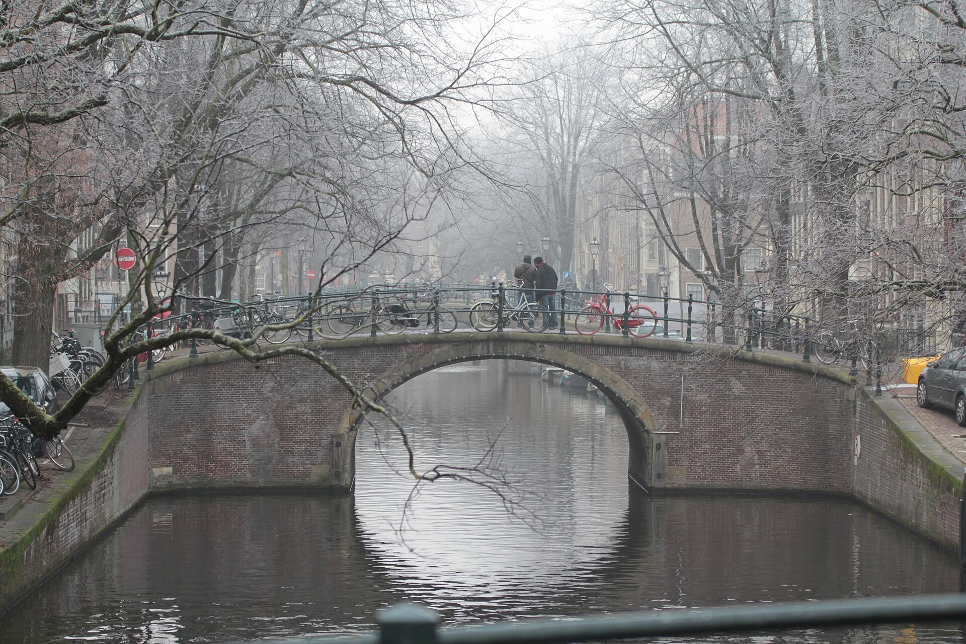
Identity and Names: The “Kerksluis” and the “Ronde Brug”
Brug 74 is a fixed bridge in Amsterdam-Centrum, located in the Kerkstraat, spanning the Reguliersgracht in the Grachtengordel. Tundria It carries two informal names, both historically rooted. The first is the Kerksluis, where “kerk” refers to the Kerkstraat on which the bridge sits, and “sluis” is simply the old Amsterdammer’s word for a stone bridge, derived from the visual resemblance of a masonry arch to the gate of a lock. Until 5 July 2016, the bridge was informally known as the Kerksluis, named after the Kerkstraat; since that date the informal designation has been discontinued. Wikipedia Its second nickname is more immediately evocative: the Kerksluis is also known as “de Ronde Brug,” the Round Bridge, because its arch together with its reflection in the water appears to form a perfect circle. Wikimedia Commons Stand on the quay in still morning air and look down: the canal acts as a mirror, the dark curve of the arch completing itself in the water below into a full, unbroken ring. It is one of the most photographed optical effects on any Amsterdam canal.
The Kerkstraat and the Kerksluis both take their name from the nearby Amstelkerk, a seventeenth-century wooden emergency church at the Amstelveld. Wikimedia Commons The street was designed to connect the churches of the fourth expansion plan of 1658, and the bridge that crosses the Reguliersgracht along its length carries that ecclesiastical history in its very nomenclature.
A Bridge Here Since 1662
A bridge has stood at this location for centuries. Daniël Stalpaert, the municipal architect, already marked a bridge here on his city plan of 1662. At that moment there was virtually no built-up development in the immediate area, but the emergency building of the Amstelkerk was already standing. Frederik de Wit also showed development on his map of 1688, and a bridge is visible there too, in the “Amstel Kerck Straet” over the “Reguliers Graft.” Tundria
A drawing from around 1760 shows a wooden bridge without an arch at this crossing; one of the quayside banks was still being used as storage space. Tundria This image, held in the Stadsarchief Amsterdam’s topographic collections, offers a rare glimpse of the crossing in its pre-masonry state: a functional timber structure, unembellished, entirely pragmatic, sitting at the edge of a neighbourhood that was still finding its shape.
Anno 1780: The Bridge That Survived the Victorian Flattening
Then came the bridge that defined everything that followed. The current bridge dates in all probability from 1780; the year is recorded on the northern side in two gevelstenen (façade stones) inscribed with “Anno” and “1780.” Tundria These two modest tablets, set into the masonry abutments of the bridge, are the key to understanding Brug 74’s exceptional historical significance. They tell you that when every other arch bridge along the Reguliersgracht was being flattened and replaced, this one remained.
From around 1860, Amsterdam replaced many of its wooden bridges and stone arch bridges with flatter, wider bridges of iron or steel. The triple wooden bridge complex at the Prinsengracht and Reguliersgracht was replaced in 1871 by a complex of three iron girder bridges. Not much later, in 1889, the wooden bridge in the Lijnbaansgracht also became a steel plate bridge. Wikimedia Commons
The bridge survived as one of the very few that escaped the flattening and widening that claimed most bridges in Amsterdam’s inner city. Because there is relatively little traffic here, the modifications could be postponed for a very long time. It therefore survived the transition to an iron girder or plate bridge and back to an arch bridge. Tundria While the great Victorian infrastructure drive swept through the canal belt, lowering and widening every crossing it could justify, Brug 74’s quiet residential location on the Kerkstraat kept it below the traffic threshold that would have condemned it. The result is that the arch you see today is, in heritage terms, the authentic survivor: not a reconstruction but a direct descendant of the 1780 original.
The 1963 Intervention: Preserved, Not Pretended
This survival does not mean the bridge has been untouched. The bridge in the Kerkstraat was demolished and fully renovated in 1963, but in doing so it retained its characteristic arch. Wikimedia Commons The key word is retained. Where the bridges at the Prinsengracht junction (Bruggen 71, 72, and 73) were flat girder bridges for approximately ninety years before the 1960s replaced them with new arches, Brug 74 entered the 1963 renovation already carrying an arch, and left it carrying the same form. The public debate around “terugrestaureren” (back-restoration) and the “architectonische leugen” (architectural lie) that surrounds its neighbours simply does not apply here in the same way. This bridge had architectural continuity; the arch was not invented but preserved.
In 1981, the deck of both Brug 74 and the bridge at the Herengracht junction was fully renewed and strengthened with reinforced concrete. Wikimedia Commons The 1981 intervention renewed the road surface and reinforced the structural substrate with modern materials, while maintaining the masonry appearance. Since then, the road surface has been relaid on a number of occasions. Tundria
The bridge has been a municipal monument (“gemeentelijk monument”) since 1995. Tundria That designation formally recognises what anyone who looks carefully already knows: this is one of the most historically significant crossings in the canal belt, not because it is the most spectacular, but because it is among the most genuinely old.
Structural Character: Eighteenth-Century Brickwork and the Cast-Iron Lantern
Both 18th-century bridges over the Reguliersgracht, the one at the Herengracht and the Kerksluis, are typical eighteenth-century arch bridges. The abutments (landhoofden) of brick, with arched and rounded cover stones of natural stone, together with a date stone, are characteristic of that period. The bridges also carry a cast-iron lantern post on each abutment. Wikimedia Commons
These cast-iron lamp posts, placed one at each corner, are among the most quietly elegant details of the bridge. They are not grand or assertive; they are simply the right scale for a bridge on a street of coachhouses and residential canal houses, and they illuminate the curve of the arch from above in a way that makes the “Round Bridge” reflection particularly vivid at night. The natural stone cover stones that cap the brick abutments also carry the weight of the arch loads with a studied simplicity that reflects the competent but unshowy civic building culture of late-eighteenth-century Amsterdam.
The Seven Bridges: Brug 74’s Place in the Alignment
Brug 74 sits at the midpoint of the Reguliersgracht alignment, roughly equidistant between the Herengracht to the north and the Prinsengracht to the south. Since 1784, when a partial infilling shortened the Reguliersgracht at its northern end, the canal has connected the Herengracht to the Lijnbaansgracht. It is half a kilometre long and crosses the Prinsengracht and the Keizersgracht. Seven arch bridges stand in one straight line over the canal. Wikimedia Commons
Only two of the seven bridges are genuinely eighteenth-century in origin and appear on the municipal monuments list: the bridge at the Herengracht, built in 1725 and reconstructed in 1784, and the Kerksluis, dating from 1780. The other five bridges are of later date. Wikimedia Commons Brug 74 is therefore not merely a decorative component of the seven-bridge view; it is, alongside the Herengracht bridge, the structural anchor of the entire alignment in historical terms. The famous “tunnel of arches” exists in its present form, as a sequence of seven, only because Brug 74 and the Herengracht bridge survived intact while the others were later rebuilt to match them. The sequence was not always there; it came together gradually, across different centuries, and was only complete in its present form after 1976 when the last flat bridge in the Lijnbaansgracht was also converted to an arch.
In the evening, hundreds of small lights illuminate the arch bridges over the Reguliersgracht, creating a perspective view with the effect of a tunnel, also known as “de tunnel der liefde,” the tunnel of love. Wikimedia Commons
Photo tip for readers: the view from the Kerkstraat looking north or south along the Reguliersgracht is the “insider” version of the seven-bridge vista. The famous postcard view is from a canal boat at water level approaching from the Herengracht. But standing on Brug 74 itself, looking north up the gentle curve of the canal toward the other arches stacked in the distance, offers a perspective that is quieter and arguably more intimate. At night, with the lamp posts lit on each abutment and the “Round Bridge” reflection forming below you, it is one of the most beautiful spots in the canal belt.
The 1901 Protest: How the Reguliersgracht Was Saved
The existence of the seven-bridge view, and therefore Brug 74’s role within it, was far from guaranteed. In 1901, the city council proposed filling in the Reguliersgracht to create more space for traffic and a future electric tram. The protests that followed were fierce. For many, the Reguliersgracht was the most beautiful of the small Amsterdam canals. It was in the struggle to preserve this canal that the society Amstelodamum, an association for the preservation of Amsterdam’s urban character, first raised its voice publicly. It supported the famous pamphlet by Jan Veth, “Stedenschennis” (City Violation), in which the well-known painter and poet argued vigorously against the proposed filling of the canal. The advocacy of so many Amsterdammers to keep the canal open succeeded. The canal was not filled in. Wikimedia Commons
This campaign is important context for understanding everything that followed, including the postwar “back-restorations” at the Prinsengracht junction. Having fought and won the battle to keep the Reguliersgracht as water, Amsterdam became increasingly committed to maintaining the aesthetic character of its bridges as part of that same argument. Brug 74, whose genuine eighteenth-century arch quietly outlasted all the controversies, is perhaps the most honest monument to that commitment.
The Neighbourhood: The Amstelveld, the Amstelkerk, and the Stadsarchief
The bridge, itself a municipal monument since 1995, is surrounded by national monuments, of which the Amstelkerk on the Amstelveld is the best known. Tundria The Amstelkerk, a wooden emergency church that has stood for more than 350 years without ever being replaced by the permanent building it was supposed to precede, is visible from the bridge. The Amstelveld, the square on which it stands, opens up just east of the crossing and offers a moment of unexpected spaciousness in a neighbourhood of otherwise enclosed canal streets.
The Kerkstraat runs parallel between the Keizersgracht and the Prinsengracht, crossing the Leidsestraat, the Nieuwe Spiegelstraat, the Vijzelstraat, the Reguliersgracht, and the Utrechtsestraat. The Kerkstraat borders the Amstelveld near number 339. The street was part of the plan for the fourth expansion, designed by Daniël Stalpaert in 1663 as an extra street between the Keizersgracht and the Prinsengracht to give the canal houses a back entrance where a coachhouse could be built. Amsterdam Travel Guide It was, in its origins, a service street for the grand canal houses facing the water, and it retains that slightly quieter, more domestic character today.
To the west, the De Bazel building on the Vijzelstraat, one of the great monuments of Amsterdam School architecture, houses the Stadsarchief Amsterdam. Its reading rooms and Beeldbank collection hold the photographs and drawings that document every stage of Brug 74’s history, from the 1760 sketch of the wooden predecessor to Jacob Olie’s late-nineteenth-century photographs of the canal belt under its industrial-era flat bridges. If you walk from Brug 74 to the Stadsarchief, you are in effect walking from the primary source to the archive that explains it.
Why Brug 74 Matters
The famous seven bridges of the Reguliersgracht attract millions of photographs, most taken from canal boats, most focused on the optical impression of stacked arches receding into the distance. What most of those photographs do not communicate is that only two of those seven arches have a genuine, unbroken line of masonry continuity reaching back to the eighteenth century. Brug 74 is one of them.
It did not need to be saved by postwar civic reconstruction. It did not need to pretend to be something older than it is. It simply survived, on a quiet residential street, because not enough traffic passed to justify its demolition, and because its 1780 arch was solid enough to carry the weight of every century since. The gevelstenen on its north face, reading “Anno 1780,” are not decoration; they are evidence. In a canal belt where heritage is often a matter of reconstruction and interpretation, Brug 74 offers the rarer and more straightforward gift of authenticity.
Primary sources and citations: Wikipedia (nl.wikipedia.org/wiki/Brug_74), the Nederlandse Bruggenstichting article “Niet alles is wat het lijkt: Zeven welfbruggen over de Reguliersgracht” by Dr. E. van Blankenstein, published in the journal “Bruggen” (2012, issue 3), drawing on: W.J. van Hoboken, “De aanleg en gedeeltelijke dempingen van de Reguliersgracht,” in Amstelodanum vol. 41 (January 1954); J.H. Kruisinga, Amsterdam, stad der duizend bruggen (Amsterdam 1973); and F. Smit, Bruggen in Amsterdam: infrastructurele ontwikkelingen en brugontwerpen van 1850 tot 2010 (Utrecht 2010). Stadsarchief Amsterdam Beeldbank: topographic collection, drawing of the Kerkstraat bridge c.1760, and Kerkstraat 1880 photograph (inventory OSIM00005003522). Bruggenvanamsterdam.nl (reguliersgracht_hoek_kerkstraat.htm).
Featured Image Door Milliped – Eigen werk, CC BY-SA 4.0, https://commons.wikimedia.org/w/index.php?curid=54619931