A Fixed Bridge on the Nieuwe Spiegelstraat at the Keizersgracht, Once Named After the Cyclists Who Crossed It
Bridge 42 carries no official name and, since July 2016, no informal one either. Until that date it was known, at least to those who kept close track of Amsterdam’s bridge geography, as the Wielrijdersbrug: the Cyclist Bridge. It was called this because, a short distance from the bridge on the Keizersgracht, there was an office and landing stage of the ANWB, the Algemene Nederlandse Wielrijders-Bond, the General Dutch Cyclists’ Union. The ANWB began as a cycling advocacy organisation in 1883 and eventually became the Netherlands’ dominant motoring association, but in its early decades its offices and members were defined by the bicycle, and the bridge near its Amsterdam premises carried that association informally. Until 5 July 2016, this bridge was unofficially known as the Wielrijdersbrug, on account of a nearby office of the ANWB with a landing stage. Since that date, the name has been abolished.
The loss of the Wielrijdersbrug name is a small but genuine piece of urban memory. It pointed, indirectly, to a moment when Amsterdam was in the early stages of becoming the cycling city it is now so famous for being. The ANWB itself was a product of that moment. The ANWB was founded on 1 July 1883 in Utrecht under the name Nederlandsche Vélocipèdisten-Bond. Two years later the name was changed to Algemene Nederlandsche Wielrijders-Bond, from which the abbreviation A.N.W.B. comes. Since the association was formally called a tourist association in 1905, the letters ANWB no longer have any meaning. The bridge that once reminded passing Amsterdammers of their cycling organisation is now simply a number.
There was a jetty in front of the building and next to the bridge although that no longer exists.
In picture 4 you get a glimpse of the Rijksmuseum along the Nieuwe Spiegelstraat.


1. Etymology and Naming: A Family, a Street, and a Quarter Built on Art and Antiques
The street Bridge 42 carries has one of the most precisely documented etymologies of any in the canal belt. The Nieuwe Spiegelstraat and the Spiegelgracht are at the heart of the Amsterdam art district, the Spiegelkwartier. The street is named after the Spiegel family, who were extremely influential. Hendrik Laurensz. Spiegel (1549 to 1612) was one of the great thinkers and writers of the 16th century. Spiegel, son of a rich merchant and soapmaker, prepared the first grammar rules for the Dutch language. One of his sons, Hendrick Dircksz Spiegel, who lived from 1598 through 1667, was burgomaster of Amsterdam in 1655, 59, 63 and 65.
The Spiegel family therefore provided both the intellectual heritage of the Dutch language and, via the son, the civic leadership of the Golden Age city. Their name passed to the street that connected their area of influence, and eventually to a bridge at its northern end.
The antique trade that now defines the street’s identity is a later development, traceable to the late 19th century. Back in the late 19th century, savvy antique dealers began opening shops on Nieuwe Spiegelstraat. Today, this area boasts over 80 specialized art and antique dealers, all lined up next to each other, creating a glamorous and stylish place to take a leisurely stroll. The Nieuwe Spiegelstraat runs between the world-famous Rijksmuseum and Keizersgracht, its history goes back as far as the 17th century. In this historic neighbourhood with its typical old Dutch houses about 100 art specialists have their galleries, offices and stores.
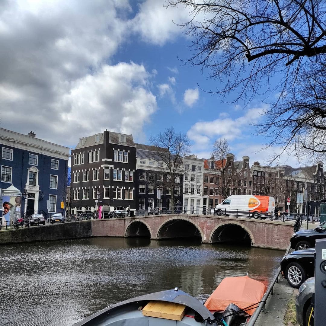
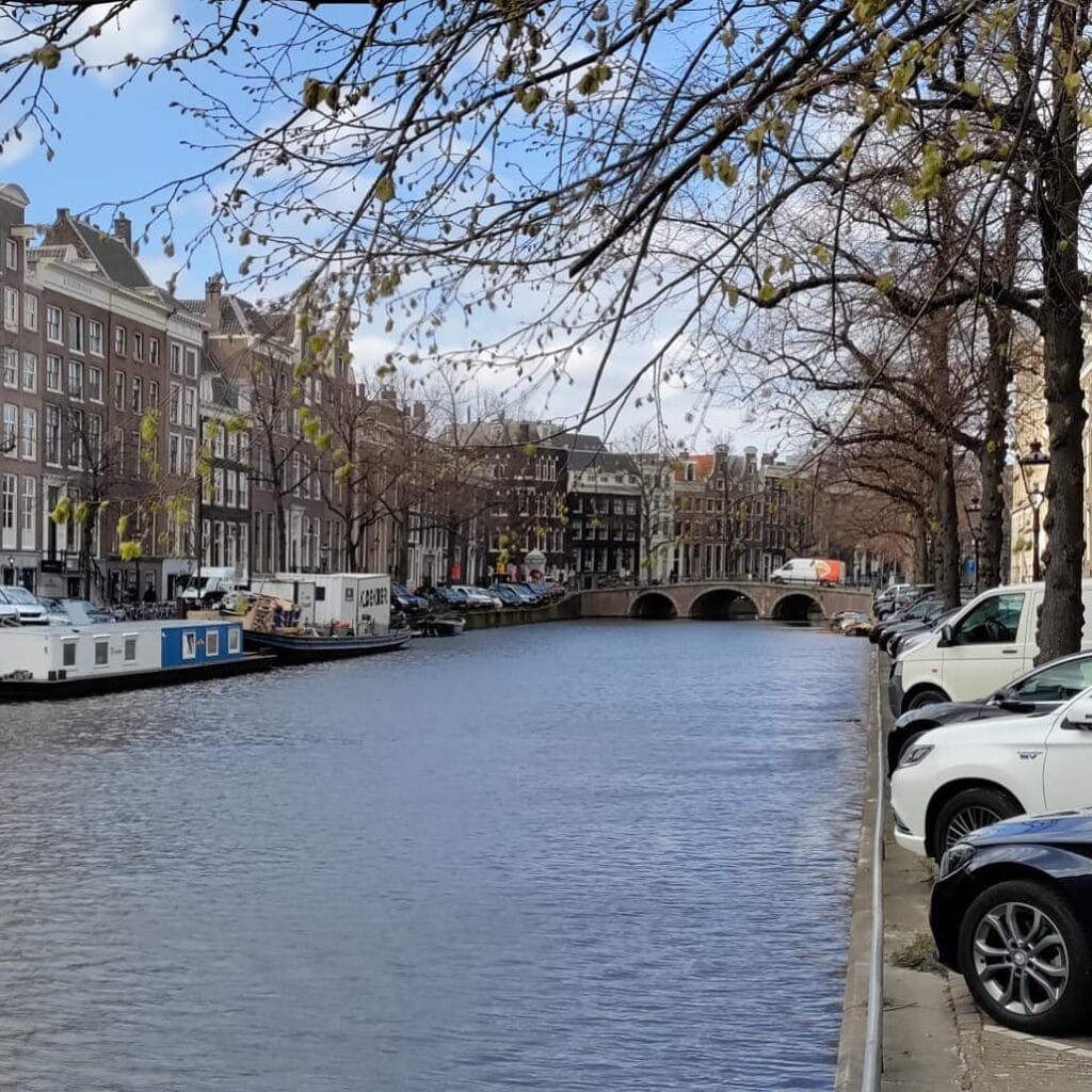
Bridge 42 sits at the canal end of this antique quarter. Crossing it from the Rijksmuseum direction, you arrive at the Keizersgracht at the point where the Spiegelkwartier delivers its finest goods to the wider city. Looking east along the Keizersgracht from the bridge, the Bridge 41 (Johanna Borskibrug) is visible a few hundred metres away. Looking west, the canal curves toward the Leidsegracht. The bridge is the gateway to the quarter in both directions.
Bridge 69, which spans the Prinsengracht at the other end of the Nieuwe Spiegelstraat near the Spiegelgracht, was informally known as the Antiquairbrug, the Antique Dealers’ Bridge, and that name was equally abolished in 2016. The name Antiquairbrug translates to Antiquarian Bridge, likely derived from the presence of numerous antique shops in the area, particularly along the Nieuwe Spiegelstraat. The two abolished bridge names, Wielrijdersbrug at the Keizersgracht end and Antiquairbrug at the Prinsengracht end, together framed the entire Nieuwe Spiegelstraat with names that described its neighbourhood identity. Both were removed on the same day in 2016.
2. Structural Evolution: Stalpaert’s Plan of 1662, and Documented on the de Wit Map of 1688
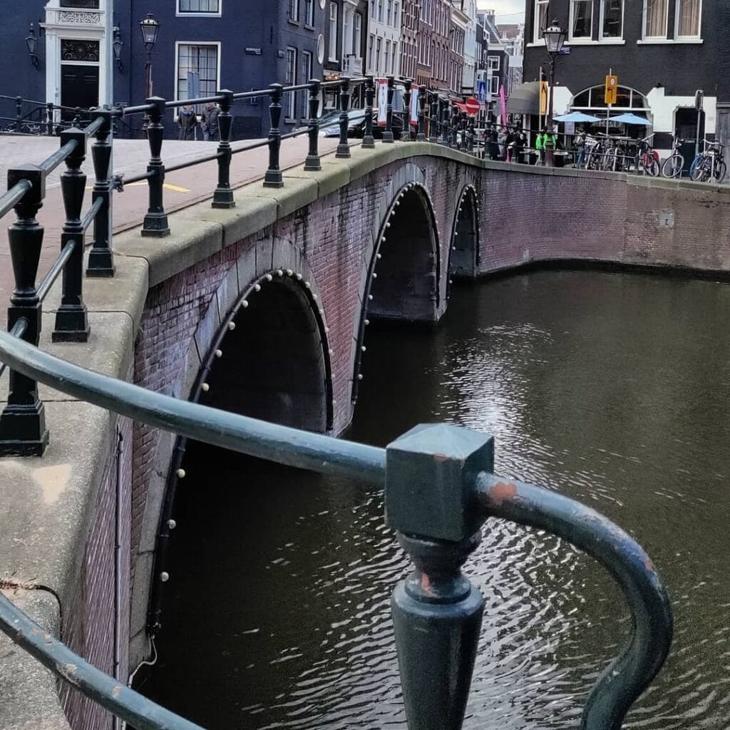
The primary sources for Bridge 42’s structural history follow the same sequence established across the southern Keizersgracht bridges in this series. City architect Daniël Stalpaert drew the bridge into the design section of his city plan of 1662, when there was still no construction at this location. Frederik de Wit’s plan from 1688 shows the bridge already in a developed neighbourhood.
No precise construction date for the current structure has been confirmed in the sources consulted for this post. The Dutch Wikipedia article on Bridge 42 and the bruggenvanamsterdam.nl register both reference Stalpaert’s 1662 plan and de Wit’s 1688 map as the primary cartographic documentation, without specifying an anno stone or a precise renovation date for the present structure.
The available Stadsarchief Amsterdam records include a photograph captioned: “Op nummer 555 hoek Nieuwe Spiegelstraat het kantoorgebouw van de Amsterdamsche Maatschappij van Levensverzekering, ontworpen door architect C.B. Posthumus Meyjes sr. (1917 to 1919). Links de Wielrijdersbrug (brug 42) met in het verlengde Nieuwe Spiegelstraat 12 to 22 (v.r.n.l.).” This photograph, dated approximately 1990, shows the bridge at its Keizersgracht crossing, with the life insurance building at Keizersgracht 555 visible at the corner, and the Nieuwe Spiegelstraat antique shops extending behind it. The photograph is the most precise visual documentation of the bridge’s context in the late 20th century.
3. Architectural Lineage: Pre-Amsterdam School, Surrounded by Rijksmonumenten
No individual architect is confirmed for Bridge 42 in any source consulted for this post. It belongs to the Dienst der Publieke Werken’s standard bridge-building tradition without a named designer.
The bridge carries no Amsterdam School design elements: no SPQA columns of the Johanna Borskibrug variety, no custom wrought iron by Kramer, no Hildo Krop sculptures. It is a fixed crossing in the standard vocabulary of Publieke Werken canal belt bridge construction, appropriate to its position on a side street between the Spiegelkwartier and the Keizersgracht.
Like several of its neighbours in this series, the bridge is surrounded by rijksmonumenten without carrying its own formal heritage designation. The Keizersgracht canal houses on both banks, the life insurance building at number 555 immediately at the corner, and the antique shops of the Nieuwe Spiegelstraat are all protected structures. The bridge connecting them is not.
The broader architectural context of Bridge 42 is dominated by two institutions that bracket it from north and south. To the north, just along the Keizersgracht, the Johanna Borskibrug (Bridge 41) carries the SPQA columns and the Amsterdam School balustrades of Piet Kramer’s 1923 design. To the south, running the full length of the Nieuwe Spiegelstraat, the antique quarter stretches toward the Rijksmuseum. Bridge 42 connects these two worlds without belonging architecturally to either.
4. Urban and Social Context: The Spiegelkwartier, the ANWB’s Legacy, and the Rijksmuseum Axis
The Nieuwe Spiegelstraat is popularly described as the driveway to the Rijksmuseum, and from Bridge 42 at its northern end that description makes immediate visual sense. The Rijksmuseum is visible through the Nieuwe Spiegelstraat from the Keizersgracht end. On a clear day, standing on Bridge 42 and looking south along the Nieuwe Spiegelstraat, the Rijksmuseum’s silhouette closes the end of the view, framed by the gabled facades of the antique dealers on either side of the street. It is one of the longest and most satisfying visual axes in Amsterdam, connecting the city’s widest canal to its greatest national museum through a quarter that has been trading in beautiful objects for over a century.
The Spiegelkwartier, which stretches along the Nieuwe Spiegelstraat and its extension, the Spiegelgracht, is the posh side of Amsterdam’s antique and fine arts scene. Back in the late 19th century, savvy antique dealers began opening shops on the Nieuwe Spiegelstraat. The quarter today houses galleries, specialist dealers in Delftware, Old Masters, scientific instruments, tribal art, and contemporary works, alongside the vintage clothing stores and lunch spots that reflect a wider shift in the street’s commercial identity in recent decades.
The cycling connection embedded in the bridge’s former name has an irony worth noting. The ANWB that once maintained an office with a landing stage near Bridge 42 was, at the time of that office, primarily a cycling organisation. Today the ANWB is the main motoring and road rescue organisation in the Netherlands but was established in 1883 as a cycling club, the Algemene Nederlandse Wielrijders-Bond. The organisation that began as a cycling advocacy body gradually became the voice of the Dutch motorist. By the time the Wielrijdersbrug name was given informal recognition, the ANWB had long since shifted its primary loyalty from the bicycle to the car. The name preserved a memory of the organisation’s original identity that the organisation itself had outgrown.
The Museum Van Loon at Keizersgracht 672 is visible to the north from Bridge 42, and Bridge 41 (Johanna Borskibrug) is the next crossing upstream. The Leidsegracht and Leidseplein are within easy walking distance to the north and west. The Rijksmuseum, Stedelijk Museum, and Van Gogh Museum are all accessible on foot through the Spiegelkwartier and Museumplein to the south.
5. Technical Specifications
Based on confirmed sources, the following can be stated:
- Bridge type: Fixed bridge (vaste brug)
- Location: Nieuwe Spiegelstraat over the Keizersgracht, Amsterdam-Centrum
- Canal: Keizersgracht (dug from 1615, widest canal in Amsterdam’s inner city at 28.31 metres; UNESCO World Heritage Canal Belt, listed 2010)
- Cartographic record: Daniël Stalpaert’s city plan, 1662 (planned, no buildings yet); Frederik de Wit’s city plan, 1688 (completed bridge in developed neighbourhood)
- No confirmed anno stone or precise construction date for current structure in sources consulted
- Designer: Dienst der Publieke Werken; no individual architect confirmed
- Amsterdam School attribution: None
- Monument status: Not a monument; surrounded by rijksmonumenten and gemeentelijke monumenten
- Former informal name: Wielrijdersbrug (Cyclist Bridge), named after a nearby ANWB office with landing stage on the Keizersgracht; abolished 5 July 2016 under Amsterdam’s policy on unofficial bridge names
- Companion abolished name: Bridge 69 (Antiquairbrug) at the Prinsengracht end of the same street, also abolished 5 July 2016
- Current official name: None; designated in the municipal register as Brug 42
- Visual axis: From the bridge, looking south along the Nieuwe Spiegelstraat, the Rijksmuseum is visible at the end of the street
- Adjacent bridge: Johanna Borskibrug (Bridge 41), a few hundred metres to the east along the Keizersgracht
Sources Consulted
- Bruggenvanamsterdam.nl, bridge register entry for Brug 42: www.bruggenvanamsterdam.nl/keizersgracht_hoek_nieuwe_spiege.htm
- Wikipedia (nl), “Brug 42”: nl.wikipedia.org/wiki/Brug_42
- Stadsarchief Amsterdam Beeldbank, photograph c. 1990, “Keizersgracht 541 to 559” (showing Wielrijdersbrug): beeldbank.amsterdam.nl/beeldbank/weergave/record/layout/print/start/120?f_sk_geografische_naam=Nieuwe+Spiegelstraat&id=GRBA00254000001
- Wikipedia (en), “Royal Dutch Touring Club (ANWB)”: en.wikipedia.org/wiki/Royal_Dutch_Touring_Club
- NieuweSpiegelstraat.com, “The Nieuwe Spiegelstraat”: www.nieuwespiegelstraat.com
- GPSmyCity, “Nieuwe Spiegelstraat”: www.gpsmycity.com/attractions/nieuwe-spiegelstraat-56362.html
- The Culture Trip, “A Guide to Amsterdam’s Antique Haven, Nieuwe Spiegelstraat”: theculturetrip.com/europe/the-netherlands/articles/a-guide-to-amsterdams-antique-haven-nieuwe-spiegelstraat
- Cicerize Me, “Nieuwe Spiegelstraat, Amsterdam”: cicerize.me/en/spot/nieuwe-spiegelstraat/
- Atlas Obscura, “Nieuwe Spiegelstraat”: www.atlasobscura.com/places/nieuwe-spiegelstraat
- Wikipedia (en), “Keizersgracht”: en.wikipedia.org/wiki/Keizersgracht
- Bridges.cramberts.com, “Brug 69, Bridge 69, History and information”: bridges.cramberts.com/amsterdam/history/brug-69-bridge-69-history-and-information/
- Wikimedia Commons, Category: Brug 42 (Amsterdam): commons.wikimedia.org/wiki/Category:Brug_42_(Amsterdam)
Public Domain Images

1. Stadsarchief Amsterdam Beeldbank: “Keizersgracht 541 to 559 hoek Nieuwe Spiegelstraat,” c. 1990 This photograph shows the Wielrijdersbrug (Bridge 42) at the left of frame with the Nieuwe Spiegelstraat antique shops extending behind it, and the Amsterdamsche Maatschappij van Levensverzekering building designed by architect C.B. Posthumus Meyjes sr. (1917 to 1919) at Keizersgracht 555 on the corner. Available via the Stadsarchief Beeldbank at archief.amsterdam. URL: https://archief.amsterdam/beeldbank/weergave/record/layout/print/start/120?f_sk_geografische_naam=Nieuwe+Spiegelstraat&id=GRBA00254000001 Attribution: “Collectie Stadsarchief Amsterdam. Available for non-commercial use with attribution.”

2. Wikimedia Commons: Category Brug 42 (Amsterdam) contemporary photographs The Wikimedia Commons category for Bridge 42 holds contemporary photographs of the bridge showing its position at the Keizersgracht and the Nieuwe Spiegelstraat axis toward the Rijksmuseum. Available under free licences. URL: https://commons.wikimedia.org/wiki/Category:Brug_42_(Amsterdam) Attribution: “Wikimedia Commons, Category: Brug 42 (Amsterdam). Available under the licences specified on individual file description pages.”
3. “Spiegelkwartier with Rijksmuseum in background,” Wikimedia Commons A public domain or freely licensed image showing the view south along the Nieuwe Spiegelstraat from the Keizersgracht end, with the Rijksmuseum visible at the end of the axis. Multiple images of this axis are available in Wikimedia Commons under various licences. URL: https://commons.wikimedia.org/wiki/Special:Search?search=Nieuwe+Spiegelstraat+Rijksmuseum&ns6=1 Attribution: “Wikimedia Commons. Available under the licence specified on each file’s description page.”
Brug 42 map and location
Like most other bridges in Amsterdam’s 17th-century Canal Ring which was added to the UNESCO World Heritage List in 2010, there has been a bridge here for centuries. City architect Daniël Stalpaert already drew a bridge here on the design part of his map of 1662 although like #bridge41 the district still had to be built around at that time. At Jacob Bosch, buildings can already be seen in 1679 and a bridge with five passageways can be seen. Frederick de Wits map from 1688 showed almost complete buildings with a bridge.


Bridge 42 history and information
Modern history of bridge 42 begins in 1890 when it was proposed to lower the bridge and widen it to ten meters. That bridge was designed by the Public Works Department of the municipality and was a recognisable appearance of graceful supports of the extensions mounted on stone beams. That bridge lasted until 1980 when the opinion prevailed that if a new bridge had to be built then it should fit better into the cityscape. A new arch bridge with three passages was created causing car and shipping traffic to be halted for a period of almost a year.
The unofficial name of the bridge was the Wielrijdersbrug after the former ANWB office located at Keizersgracht 590. However, in April 2016 all unofficial names were either made official or withdrawn by the municipality and it is no surprise therefore that the unofficial name for this bridge expired and it remains unnamed.
Pictures from Amsterdam Archive
1 Bridge 42 at Nieuwe Spiegelstraat, seen towards Vijzelstraat undated
2 In the foreground: urinal and behind bridge no. 42, seen towards the Nieuwe Spiegelstraat entrance Martin Alberts, 5 juli 1991
3 Seen in a southerly direction to bridge 42 at entrance Nieuwe Spiegelstraat
Svend Elmgvist 1925 t/m 1926
4 Viewed west to Bridge 42 at Nieuwe Spiegelstraat. Right Keizersgracht 545-589. Photo from ‘Scrapbook’, album with 178 city views of Amsterdam and elsewhere, compiled by Jacob Olie himself. maart 1901
5 At number 555 corner Nieuwe Spiegelstraat the office building of the Amsterdam Society of Life Insurance, designed by architect C.B. Posthumus Meyjes sr. (1917-1919). Left the Wielrijdersbrug (bridge 42) with Nieuwe Spiegelstraat 12-22 (from left to right) in the extension. Annemieke van Oord-de Pee 1990
6 Right the Wielrijdersbrug (bridge 42) to the Nieuwe Spiegelstraat with numbers 26-36 (from left to right). Annemieke van Oord-de Pee 1990


