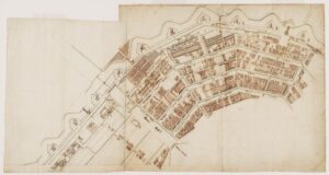
The 1679 map by Jacob Bosch serves as a vital historical bridge, capturing Amsterdam at the precise moment it reached its territorial maturity. Following the ambitious master plans laid out by Daniel Stalpaert in 1662, Bosch’s map documents the reality of that construction nearly two decades later. By 1679, the “Grote Uitleg” (Great Expansion) was no longer just a set of architectural drawings; it was a physical reality of brick, water, and stone. This map provides an essential record of the city just as it was finalizing the eastern section of the canal belt, showing how the Herengracht, Keizersgracht, and Prinsengracht successfully crossed the Amstel River toward the Plantage.
What makes the Bosch map particularly fascinating is its meticulous rendering of the city’s defensive perimeter. At this point in the late 17th century, Amsterdam was protected by a sophisticated system of twenty-six massive stone and earthen bastions, each named and strategically placed to withstand modern artillery. Bosch’s copperplate engraving is remarkably clear in its depiction of these fortifications, complete with the windmills that sat atop them to harness the wind from the surrounding polders. This map reflects a city that was not only a center of trade but also a formidable fortress, prepared for the geopolitical tensions that defined the era.
Beyond the military and structural details, the 1679 edition offers a rare glimpse into the social and functional zoning of the city. You can clearly see the contrast between the wide, prestigious lots of the main canal houses and the more industrial, densely packed streets of the Jordaan and the Oostelijke Eilanden (Eastern Islands). The map also highlights the growing importance of the Plantage area to the east, which Bosch depicts as a series of neatly divided green plots. Originally intended for housing, these areas became a “green lung” for the city, housing botanical gardens and leisure spaces for the wealthy elite who wanted an escape from the busy urban core.
Technically, the Bosch map is a masterpiece of 17th-century engraving, often featuring a grand title shield supported by allegorical figures and a detailed “Legenda” or key. This index allowed users to quickly locate churches, weigh-houses, markets, and municipal buildings, making it a highly functional tool for both residents and visitors. For historians, this map is the definitive proof of Amsterdam’s “completed” horseshoe shape before the industrial shifts of the 19th century. It captures the city at its peak, documenting an urban footprint that has remained largely unchanged for centuries and continues to define the character of the city today.

Explore the Evolution of Amsterdam
The 17th-century cartography of the Dutch Republic is a testament to the city’s rapid global expansion. This post is part of our comprehensive chronological archive.
- ← Previous Map: 1662 Daniel Stalpaert
- Main Collection: Maps of Amsterdam: A Chronological Guide
- Next Map: → 1688 Frederick de Wit
This 1679 map by Jacob Bosch of Amsterdam is a key part of our Chronological Guide to the Maps of Amsterdam, which documents the city’s growth from a medieval port to a global capital.
Disclaimer: These works are in the public domain in their country of origin and other countries and areas where the copyright term is the author’s life plus 100 years or fewer.