
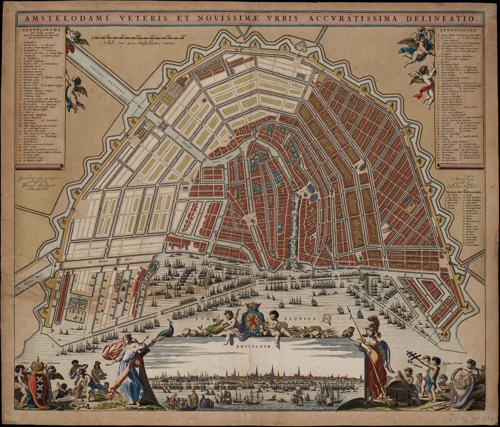
The 1662 map by Daniel Stalpaert is one of the most significant administrative documents in the history of urban planning. While earlier maps by artists like Van Berckenrode or Blaeu were often created as luxury items for wealthy merchants, Stalpaert’s map served a more practical and transformative purpose. As the first official Stadsbouwmeester (City Architect) of Amsterdam, Stalpaert didn’t just record what the city was; he used this map to dictate what the city would become. This work is essentially the master plan for the “Fourth Expansion,” the final and most ambitious phase of the 17th-century canal belt project.
What makes the 1662 map unique is its dual nature. Stalpaert utilized a clever visual system to distinguish between the existing city and the planned construction. The established urban core is rendered with fine detail, while the proposed extensions of the Herengracht, Keizersgracht, and Prinsengracht—stretching all the way east toward the Amstel River—are laid out with the clean, geometric lines of an architect’s drafting table. This map allowed the city council to visualize how the iconic horseshoe shape would finally be completed, effectively bridging the gap between a medieval port and a modern, symmetrical metropolis.
Technically, Stalpaert’s work is prized for its mathematical accuracy. Because he was the man responsible for overseeing the actual construction of the bridges, locks, and fortifications, his map provides a reliable record of the city’s infrastructure. It meticulously depicts the twenty-six new bastions that would form the city’s outer defensive ring, as well as the specialized industrial zones like the Jordaan. Unlike the stylized “bird’s-eye” views of the past, this map prioritizes the “Grondtekening” (ground plan), offering a clear, top-down perspective that served as the official administrative reference for decades.
Beyond its utility, the 1662 map is a symbol of Amsterdam’s peak institutional power. It captures the city at the exact moment it decided to commit to one of the most expensive and well-organized urban expansions in human history. Stalpaert’s influence is visible in every corner of the plan, from the placement of public squares to the rhythmic spacing of the canal houses. For historians, this map is the “DNA” of modern Amsterdam, showing exactly how the city’s most famous landmarks were conceived before a single brick was laid in the final eastern sectors.
Explore the Evolution of Amsterdam
The 17th-century cartography of the Dutch Republic is a testament to the city’s rapid global expansion. This post is part of our comprehensive chronological archive.
- ← Previous Map: 1657 Van Berckenrode
- Main Collection: Maps of Amsterdam: A Chronological Guide
- Next Map: → 1679 Jacob Bosch

This 1662 map by Daniel Stalpaert of Amsterdam is a key part of our Chronological Guide to the Maps of Amsterdam, which documents the city’s growth from a medieval port to a global capital.
Disclaimer: These works are in the public domain in their country of origin and other countries and areas where the copyright term is the author’s life plus 100 years or fewer.