An Arch Bridge on the Northeastern Quay of the Keizersgracht, Spanning the Leidsegracht, and the Memory of the City’s Most Important 17th-Century Workshop
Bridge 45 sits directly across the Keizersgracht from Bridge 44, the two crossings facing each other from opposite quays where the Leidsegracht meets the canal at its widest point. Where Bridge 44 was named after bell founders and rebuilt in the 1970s to restore a lost arch, Bridge 45 carries a name that points directly at the working life of 17th-century Amsterdam: it is named after the stone cutters who worked in the Stads Metseltuin (City Mason’s Yard) on the Leidsegracht.
That yard was not a peripheral workshop. It was the production centre for some of the most significant stonework in the Dutch Golden Age. Understanding the Steenhouwerijbrug means understanding where the stone came from that made Amsterdam look the way it does.


1. Etymology and Naming: The City Mason’s Yard, Artus Quellinus, and the Dam Square Town Hall in Stone
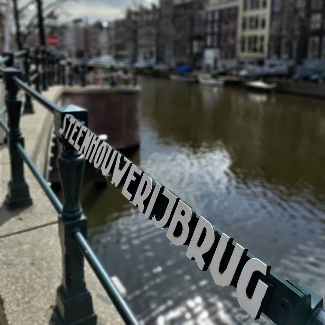
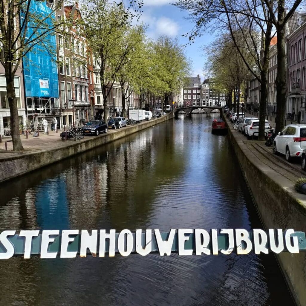
The name Steenhouwerijbrug, Stone Cutters’ Bridge, is one of the most directly descriptive in the entire Amsterdam bridge series. The alternative name Steenhouwerijsluis is also used. As with several earlier bridges in this series, “sluis” in this context means a stone bridge rather than a hydraulic lock.
The Stads Metseltuin to which the bridge’s name refers was a city-run workshop and yard that served Amsterdam’s building programme at its most ambitious. During the time of Hendrick de Keyser, who was city master stone cutter and image carver, the Stadssteenhouwerij was established on a reclaimed island near the Staalstraat, where the master builder also lived. During the construction of the new Town Hall on Dam Square, the stone cutters’ yard was temporarily located on a plot of land enclosed between the Herengracht, Leidsegracht, and Keizersgracht. Here Quellinus worked on his statues for the Town Hall.
This location also had to be cleared for residential building, as had happened earlier with the workshop on the Amstel, which occurred around 1663. The Stadssteenhouwerij, which was also a mason’s yard (the stones for the new Town Hall were cut here too), was then moved to a site at the Baangracht, stretching across what is now the Raamplein.
The precision of this history is extraordinary: the plot between the Herengracht, Leidsegracht, and Keizersgracht, directly at Bridge 45’s location, was the temporary home of the workshop where Artus Quellinus I carved the tympanum sculptures and the bronze doors of the Dam Square Town Hall, now the Royal Palace. Around 1663, the Stad-Metzel-Tuyn with its city stone cutters’ yard offered accommodation to master masons, city architects, and city builders. As documented at the time: “The city masonry foreman has his dwelling and oversight there over both the Stone Cutters and the Masons. Here also is stored the supply of stone, lime, and other necessities for the daily requirements of the City.”
The Stadsherstel Amsterdam documentation for Leidsegracht 106 confirms this with remarkable specificity: the Stad-Metzel-Tuyn was established around 1663 at the schans, the 17th-century city wall where the Marnixstraat now runs, which was then the southern border of the built city. It was placed at the head of the Baangracht, the current Lijnbaansgracht. City architect Stalpaert was among the neighbours.
The bridge’s name therefore carries, compressed into a single Dutch compound word, the entire weight of Amsterdam’s 17th-century civic building programme: the Town Hall, the stone, the carvers, the supervisors, and the yard that produced them all.
2. Structural Evolution: Stalpaert’s Plan of 1662, the Collapse of Bridge 46, and the “Architectural Lie” of 1978
The documentary and structural history of Bridge 45 is almost a mirror image of Bridge 44, its neighbour directly across the Keizersgracht. The two bridges were built at the same moment, their histories were shaped by the same collapse event, and both were rebuilt to arch form in the 1970s for the same aesthetic reasons. The differences between them are small but precise, and Bridge 45 has the slightly richer documentary record.
Frederik de Wit’s map of 1688 shows the bridge. At the end of the 19th century, a simple plate bridge appeared here. This came about because the adjacent Bridge 46, an arch bridge over the Keizersgracht, had collapsed. This fed the fear that other arch bridges would also collapse. Moreover, at that time there was less appreciation for the aesthetic value of the bridge.
Bridge 46 (the Quellijnbrug) is the direct cause of Bridge 45’s 19th-century transformation. The collapse of a neighbouring crossing triggered a precautionary replacement across the entire immediate area. As established in the Bridge 44 post, this kind of structural contagion reasoning, replacing sound arches because a different arch had failed, was characteristic of late 19th-century municipal engineering. The precaution removed the aesthetic continuity of the Keizersgracht at this point for nearly a century.
When the bridge became due for major maintenance in the 1970s, the situation was reversed. The skill for arch bridges had been recovered and there was a desire for a bridge that fits into the streetscape. The arch bridge came back here in 1978. At the time it was described as an “architectural lie,” a bridge in the style of the 17th century but with a concrete span and corresponding foundation. After completion, the bridge could again last for a long time.
The phrase “architectonische leugen,” architectural lie, is a fascinating piece of 1970s heritage criticism. The objection was that the new arch, built in concrete and faced to look like a historic stone arch, was pretending to be something it was not. The counterargument, which won the day, was that a bridge that restores visual continuity to a historic urban setting is serving the landscape rather than deceiving it. The bridge’s concrete core is now hidden behind stone facing that has weathered for nearly fifty years, and today it is indistinguishable, in its visual effect, from the genuinely 18th-century arches elsewhere on the Keizersgracht and Leidsegracht.
A Stadsarchief Amsterdam photograph, referenced in the archief.amsterdam Beeldbank, shows the Steenhouwerijbrug (Bridge 45) with behind it the Leidsegracht looking toward the Herengracht, Leidsegracht 27, and Keizersgracht 421 to 427. This image, taken before the 1978 reconstruction, provides a direct visual record of the plate bridge at Bridge 45, in the same photograph that also shows Bridge 46 (the Quellijnbrug) in the adjacent position.
3. Architectural Lineage: A 1978 Arch in Historical Form, Opposite Its Mirror Image at Bridge 44
No individual architect is confirmed for the current Bridge 45 in any source consulted for this post. It belongs to the Dienst der Publieke Werken’s 1970s bridge restoration programme without a named designer.
The arch bridge is situated in the northeastern quay of the Keizersgracht and spans the Leidsegracht. It sits directly opposite Bridge 44, which occupies the southwestern quay of the same crossing and was similarly rebuilt as a new arch in the 1970s. The two bridges, reconstructed at the same time for the same aesthetic reasons by the same municipal authority, are as close to structural twins as any pair in this series: both are 1970s concrete arches in historical facing, both span the Leidsegracht at the Keizersgracht, both were preceded by late 19th-century plate bridges, and both are surrounded by rijksmonumenten without carrying their own heritage designation.
The one meaningful distinction between the two is exactly stated in the Dutch Wikipedia article: the bridge itself is not a monument, as it is too recent for that, but it is surrounded by rijksmonumenten. The bridge lies opposite Bridge 44 (southwestern quay of the Keizersgracht over the Leidsegracht).
The combined effect of Bridges 44 and 45 at this crossing, two new arches facing each other across the Keizersgracht, creates the aesthetic continuity that the 1970s planners intended. A visitor who does not know that both bridges are 1970s reconstructions will simply see an 18th-century arch canal junction, which is exactly the visual experience the Keizersgracht offers everywhere else along its length.
4. Urban and Social Context: The Leidsegracht’s Historic Boundary, the Foam Museum, and a Crossing Framed by Two Centuries of Stone
Bridge 45 sits at the point where the Keizersgracht’s first phase of construction ended and its second began. The first part of the Keizersgracht, between Brouwersgracht and approximately the current Leidsegracht, was dug in the summer of 1615. The section between the Leidsegracht and the Amstel belongs to the Fourth Amsterdam Expansion of 1658. The actual digging of this part of the Keizersgracht began in 1663. In 1667 both parts of the Keizersgracht were connected to each other.
Bridge 45 therefore sits precisely at the seam between the Keizersgracht of 1615 and the Keizersgracht of 1663, the point where the canal’s two construction phases meet. The bridge’s own name is rooted in the period between those two dates: the Stads Metseltuin was established around 1663, at the very moment the southern extension of the canal was being dug. The stone cutters whose yard gave the bridge its name were working at the same time and in the same location as the canal that carries the bridge was being excavated. The Steenhouwerijbrug is therefore, in a very precise sense, named after the workers who built the canal around it.
The Foam Photography Museum at Keizersgracht 609 is within easy walking distance to the north along the canal. The Museum Van Loon and Bridge 37 are further north along the Keizersgracht. The Leidsegracht, spanning to the east and west of Bridge 45, is one of the most harmoniously preserved of Amsterdam’s smaller canals, its length lined with protected 17th and 18th-century houses and crossed by arch bridges that survived the 19th-century modernisation drive that replaced Bridges 44 and 45 with plate structures.
Looking east from Bridge 45 along the Leidsegracht, the towers of the Westerkerk are visible in the middle distance on a clear day. Looking west, the Lijnbaansgracht marks the outer edge of the canal belt at the point where the Stads Metseltuin once operated. The entire view from Bridge 45 is framed by the urban fabric that the stone cutters of that yard helped to build.
5. Technical Specifications
Based on confirmed sources, the following can be stated:
- Bridge type: Fixed arch bridge (vaste welfbrug), 1978 construction in historical arch form with concrete span and foundation
- Location: Northeastern quay of the Keizersgracht, spanning the Leidsegracht, Amsterdam-Centrum
- Canals: Keizersgracht (the first section dug 1615, between Brouwersgracht and Leidsegracht; the second section dug from 1663 between Leidsegracht and Amstel; UNESCO World Heritage Canal Belt, listed 2010); Leidsegracht (constructed from 1615, southern boundary of Amsterdam until 1658)
- Position: Directly opposite Bridge 44, which occupies the southwestern quay of the same Keizersgracht/Leidsegracht crossing; the two bridges form a complementary pair
- Cartographic record: Frederik de Wit’s city map, 1688 (bridge shown in developed neighbourhood); Stalpaert’s 1662 plan shows the wider area
- Late 19th century: Original arch bridge replaced with a simple plate bridge following the collapse of the adjacent Bridge 46 (Quellijnbrug); precautionary decision based on fear of arch failure generally
- 1978: Major maintenance; plate bridge replaced with new arch bridge in historical style with concrete span and concrete foundation; described at the time as an “architectonische leugen” (architectural lie) but accepted as a restoration of visual continuity
- Designer: Dienst der Publieke Werken (1978 reconstruction); no individual architect confirmed
- Amsterdam School attribution: None; the bridge is a 1978 construction
- Monument status: Not a monument (geen monument), the bridge being too recent for listing; surrounded by rijksmonumenten
- Official name: Steenhouwerijbrug (officially adopted; the name refers to the stone cutters who worked in the Stads Metseltuin on the Leidsegracht)
- Alternative name: Steenhouwerijsluis (also in use; “sluis” here meaning stone bridge rather than hydraulic lock)
- Historical connection: The Stads Metseltuin was temporarily located between the Herengracht, Leidsegracht, and Keizersgracht during the construction of the Dam Square Town Hall (now the Royal Palace), where Artus Quellinus I worked on his sculptures; the yard moved to the Lijnbaansgracht area around 1663
Sources Consulted
- Bruggenvanamsterdam.nl, bridge register entry for Brug 45: www.bruggenvanamsterdam.nl/keizersgracht_hoek_leidsegracht1.htm
- Wikipedia (nl), “Steenhouwerijbrug”: nl.wikipedia.org/wiki/Steenhouwerijbrug
- Ensie.nl XYZ van Amsterdam, “Stadssteenhouwerij”: www.ensie.nl/xyz-van-amsterdam/stadssteenhouwerij
- Stadsherstel Amsterdam, “Leidsegracht 106 / Raamdwarsstraat 11”: stadsherstel.nl/monumenten/leidsegracht-106_raamdwarsstraat-11/
- Stadsarchief Amsterdam Beeldbank, “De Steenhouwerijbrug (brug 45) met daarachter de Leidsegracht gezien naar de Herengracht”: archief.amsterdam/beeldbank/detail/81bbf74a-7bed-ad68-848f-e398b5b4bd7e
- Wikipedia (en), “Keizersgracht”: en.wikipedia.org/wiki/Keizersgracht
- Wikipedia (en), “Leidsegracht”: en.wikipedia.org/wiki/Leidsegracht
- Grachtenmuseum Amsterdam, “History”: grachten.museum/en/history/
- UNESCO World Heritage Urban Heritage Atlas, “Seventeenth-Century Canal Ring Area of Amsterdam”: whc.unesco.org/en/urban-heritage-atlas/Amsterdam/
- Wikipedia (en), “Artus Quellinus”: en.wikipedia.org/wiki/Artus_Quellinus
- Wikimedia Commons, Category: Brug 45 (Amsterdam): commons.wikimedia.org/wiki/Category:Brug_45_(Amsterdam)
- Frank V. Smit, “Bruggen in Amsterdam,” Matrijs 2008 (cited in Wikipedia nl, “Steenhouwerijbrug”)
Public Domain Images

1. Stadsarchief Amsterdam Beeldbank: “De Steenhouwerijbrug (brug 45) met daarachter de Leidsegracht gezien naar de Herengracht, Leidsegracht 27, Keizersgracht 421-427” This photograph, captioned precisely as showing the Steenhouwerijbrug (Bridge 45) with behind it the Leidsegracht looking toward the Herengracht, is held in the Stadsarchief Amsterdam Beeldbank and also shows Bridge 46 (Quellijnbrug) in the adjacent position on the Keizersgracht. This is the most direct archival image of Bridge 45 in its pre-1978 plate bridge form. Available for non-commercial use with attribution. URL: https://archief.amsterdam/beeldbank/detail/81bbf74a-7bed-ad68-848f-e398b5b4bd7e Attribution: “Collectie Stadsarchief Amsterdam. Available for non-commercial use with attribution.”
2. Wikimedia Commons: Category Brug 45 (Amsterdam) contemporary photographs The Wikimedia Commons category for Bridge 45 holds contemporary photographs of the bridge in its current 1978 arch form, showing its position on the northeastern quay of the Keizersgracht and the Leidsegracht visible beyond. Available under free licences. URL: https://commons.wikimedia.org/w/index.php?search=brug+45+amsterdam&title=Special%3AMediaSearch&type=image Attribution: “Wikimedia Commons, Category: Brug 45 (Amsterdam). Available under the licences specified on individual file description pages.”

3. “Stadsmetseltuin en Leidsegracht 106 in 1932,” photograph by C.F. Jansen, Stadsarchief Amsterdam This photograph, cited by Stadsherstel Amsterdam as “Stadsmetseltuin en Leidsegracht 106 in 1932, Foto: Jansen, C.F., Stadsarchief Amsterdam,” shows the Stads Metseltuin building on the Leidsegracht in its early 20th-century form, directly at the location named in the Steenhouwerijbrug’s etymology. Available via the Stadsarchief Beeldbank at archief.amsterdam. URL: https://archief.amsterdam/beeldbank (search: “Stadsmetseltuin Leidsegracht 1932 Jansen”) Attribution: “C.F. Jansen, 1932. Collectie Stadsarchief Amsterdam. Available for non-commercial use with attribution.”
Brug 45 aka Steenhouwerijsluis map and location
Not much to say about the location of Brug 45 as it’s fairly similar to #bridge44 although is located on the southwest bank of the Keizersgracht. The bridge spans the Leidsegracht.
Both #brug44 and #brug46 are also located at this ‘junction’.


Steenhouwerijbrug history and information
This bridge has a very similar history to #brug44 including it being a slab bridge at the end of the 19th century because the adjacent #bridge46, also an arch bridge had collapsed over the Keizersgrachtand again recent renovations converted it to a more aesthetically pleasing arched bridge. The bridge is drawn on the boundary between the built-up area and his design for the new district south of the Leidsegracht. Frederick de Wits map from 1688 shows the bridge in place.


Pics from Amsterdam Archive
1+2
Bridge No. 45 before restoration April 1974
3 Left Bridge 45. In the background Keizersgracht 452-462 and Leidsegracht 34-38. 1894
4 In the foreground the Steenhouwerijbrug (Bridge 45). Original cabinet photo published by A. Jager. 1868 t/m 1875
5 Left on the corner Keizersgracht 419 and in the foreground left Bridge 46 over the Keizersgracht and middle Bridge 45 over the Leidsegracht. The towers of the Roman Catholic church De Krijtberg on the Singel in the offing. Postcard by A.J. Nuss. 1910
6 Bridge 45 December 1980
7 +8
Bridges 44-45-46 December 1980