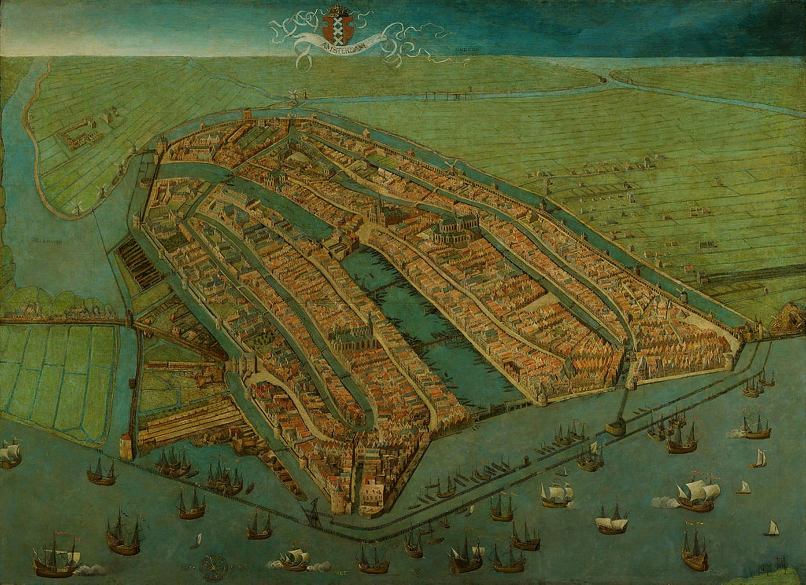
The 1538 map of Amsterdam holds the prestigious title of the oldest surviving map of the city. Painted in oil on wooden panels by Cornelis Anthonisz., this masterwork predates his more famous 1544 woodcut. While the later woodcut allowed for mass production and wider distribution, this 1538 painting was a singular, high-status object likely commissioned for the Amsterdam Town Hall. It offers an unparalleled glimpse into the late medieval city just as it stood on the precipice of its global transformation.
What makes the 1538 map truly remarkable is its perspective. Anthonisz. employed a “birds-eye view” that was revolutionary for its time, creating a three-dimensional effect that allows us to see the city as if from a low-flying aircraft. We see a compact, fortified town huddled around the mouth of the Amstel River. The city is still dominated by its medieval landmarks: the Oude Kerk and Nieuwe Kerk tower over a dense cluster of wooden and early brick houses, all protected by a series of canals and defensive walls that look modest compared to the grand bastions of the 17th century.
Beyond its geographical data, the 1538 painting is a vivid historical document. It captures the bustling life of the harbor, with small cog ships and sailing vessels reflecting Amsterdam’s early role in the Baltic trade. Because it is a painting rather than a print, the colors and textures provide a sense of the city’s physical atmosphere that later engravings lack. This map is the foundation of Amsterdam’s cartographic history, serving as the primary source for every subsequent depiction of the city’s origins.

Explore the Evolution of Amsterdam
The 17th-century cartography of the Dutch Republic is a testament to the city’s rapid global expansion. This post is part of our comprehensive chronological archive.
- Main Collection: Maps of Amsterdam: A Chronological Guide
- Next Map: → 1544 Anthonisz (Woodcut)

This 1538 map of Amsterdam by Cornelis Anthonisz. is a key part of our Chronological Guide to the Maps of Amsterdam, which documents the city’s growth from a medieval port to a global capital.
Disclaimer: These works are in the public domain in their country of origin and other countries and areas where the copyright term is the author’s life plus 100 years or fewer.