This post explores the era when Amsterdam was less of a “Venice of the North” and more of a high-security fortress.
Amsterdam the city as a Fortress
Imagine Amsterdam not as an open, welcoming canal city, but as a high-security stronghold. In the 16th and 17th centuries, every major entrance to the city was a strategic bottleneck. The bridges we walk across today were once the literal “keys” to the city. If an enemy approached, the chains rattled, the wooden planks rose, and Amsterdam became an impenetrable island.
The Anatomy of a Fortress Bridge
In the era of the Stadspoort (City Gate), a bridge was rarely just a way to cross water. It was a sophisticated defensive machine. These bridges were almost exclusively heavy wooden drawbridges, often controlled by massive internal pulleys located inside the gatehouse itself.
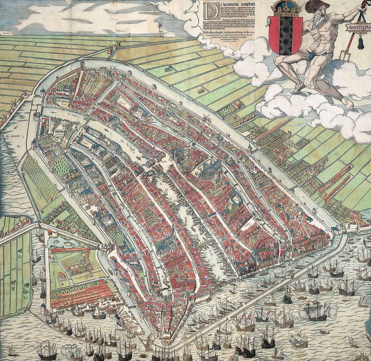
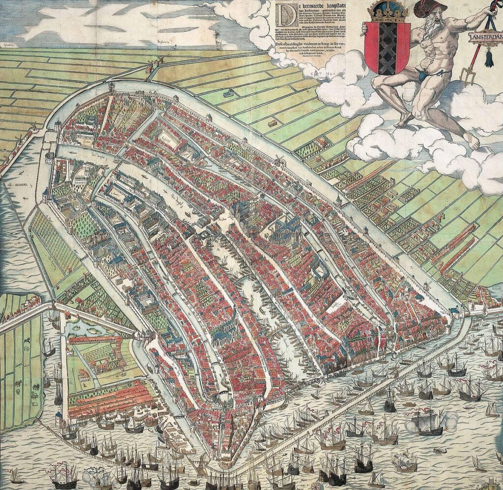
By looking at the 1544 Cornelis Anthonisz. Woodcut, you can see the city still huddled behind its medieval stone walls. The bridges at this time were narrow and served as the final hurdle for anyone trying to enter the city after the bells signaled the closing of the gates at sunset.
The Great Vanishing: Haarlemmerpoort and Leidsepoort
As Amsterdam expanded in the 17th century, the old medieval walls were replaced by a sprawling system of 26 bastions. However, even these newer defenses eventually became obstacles to the city’s growth.
- The Haarlemmerpoort: This was the grand gateway to the west. While the current neoclassical building dates from 1840, the original versions were true fortifications. The bridge leading to it was the primary link for travelers coming from Haarlem.
- The Leidsepoort: Serving as the southern entrance, this gate stood near what is now Leidseplein. It was a massive structure that processed everyone traveling from Leiden and The Hague.
When the city walls were finally demolished in the 19th century to allow for better traffic flow and ventilation, the gate buildings were torn down. However, the water remained, and the strategic locations of these gates meant that the bridges had to stay. Today, places like Leidseplein or the area around the Haarlemmerplein are still defined by the bridges that once served as the thresholds of a fortress.
The Phantom Geography: Why the Canal Belt Stops
Have you ever wondered why Amsterdam’s iconic concentric canals—the Herengracht, Keizersgracht, and Prinsengracht—abruptly stop at the Singelgracht? This isn’t a modern urban planning quirk; it is the “ghost” of the city’s 17th-century defenses. The Singelgracht was originally the outer moat of the city’s massive ramparts. When the 1662 Daniel Stalpaert map was drawn, it wasn’t just a street guide; it was a military blueprint showing where the stone walls met the water.
Why does Amsterdam’s Canal Belt stop where it does?
Because the city was a literal island fortress, the canal expansion had to respect the line of the 26 massive bastions. Even today, if you look at a satellite map of the city, the “zigzag” shape of the outer park system (like the Sarphatipark area) follows the exact jagged points of the old star-fort bastions. The bridges crossing the Singelgracht today sit precisely where the heavy drawbridges of the Golden Age once controlled all entry and exit.
The Night Watch: Guarding the Gate Bridges
The bridges of Amsterdam weren’t just for commerce; they were the frontline of the Schutterij, the civic guard immortalized in Rembrandt’s The Night Watch. Every evening, a ritual known as the “Poortklok” (Gate Bell) would ring for fifteen minutes. This was the final warning for citizens to return inside the walls. Once the bell stopped, the heavy wooden drawbridges were hoisted up, the iron portcullis was dropped, and the city was sealed shut for the night.
The Night Watch and Amsterdam’s Forgotten Curfew
The men in Rembrandt’s famous painting were responsible for manning these very gates, such as the Sint Anthoniespoort (now the Waag on Nieuwmarkt). If you were a merchant arriving five minutes late, you were forced to spend the night in an inn outside the walls. This nightly “bridge raising” is a theme you can trace through the 1599 Pieter Bast map, which shows the city’s gates as dominant, high-security structures that dictated the life and movement of every Amsterdamer.
The Boomsluiting: Locking the Water Gates
While the land gates protected the roads, Amsterdam had an even more unique challenge: protecting the harbor. To prevent enemy ships from slipping into the city via the Amstel or the IJ at night, the city employed a system called the Boomsluiting. These were massive, iron-bound wooden beams (booms) that were floated across the water at sunset. They functioned like horizontal drawbridges for the water, effectively “locking” the canals.
How Amsterdam used “Water Gates” to protect the harbour
You can see these water barriers clearly illustrated in the 1544 Cornelis Anthonisz. woodcut and the 1599 Pieter Bast map. Specialized “Boom Masters” lived in small houses near the water’s edge to manage these heavy timbers. Today, the locations of these old water gates are still marked by wide, strategic bridges that transition the city from the narrow internal canals to the vast open water of the harbor.
Surviving Remnants: A Fortress Scavenger Hunt
Most of Amsterdam’s gates were demolished in the 19th century to improve air circulation and traffic, but if you know where to look, the fortress still speaks. The Waag on Nieuwmarkt is the most famous survivor—originally the Sint Anthoniespoort, built in 1488. Nearby, the Schreierstoren still stands as a defensive tower where wives once waved goodbye to sailors, and the Munttoren (Mint Tower) was actually part of the Regulierspoort, one of the city’s main southern gates.
The Waag: Formerly the Sint Anthoniespoort (1488).
The Munttoren: Formerly part of the Regulierspoort.
The Schreierstoren: A defensive tower on the harbor.
Bridge Names: Many bridges are still named after the gates they replaced (e.g., the Leidsepoortbrug).
Where to find the remains of Medieval Amsterdam’s walls
For the modern explorer, the best way to “see” the vanished gates is through the bridge names. The Leidsepoortbrug and Haarlemmerpoortbrug are literal place-markers for where the massive stone towers once stood. By comparing these modern locations to the 1737 Gerrit de Broen map, you can stand on a modern bridge and visualize exactly where the drawbridge chains once rattled and the city guards stood their ground.
Tracing the Gates on the Maps
To truly understand the scale of these fortifications, you have to look at the transition between the 16th and 17th-century plans.
- 1599 Pieter Bast: This map captures the city just as the first major expansions were beginning. You can still see the clear distinction between the “inner” city and the defensive perimeter. View the 1599 Pieter Bast Map.
- 1662 Daniel Stalpaert: By this time, the city had moved toward the bastion system. The gates were grander, more architectural, and the bridges were becoming wider to accommodate the massive increase in trade and carriage traffic. View the 1662 Daniel Stalpaert Map.
Today, these “Vanishing Gates” leave behind a phantom geography. We cross the bridges without thinking of the soldiers, toll collectors, and gatekeepers who once stood guard there, but the layout of the city still follows the lines of defense drawn centuries ago.
Further Reading
- This exploration is part of our series on the Maps of Amsterdam.
- Learn more about how these defensive structures influenced Piet Kramer’s modern designs centuries later.