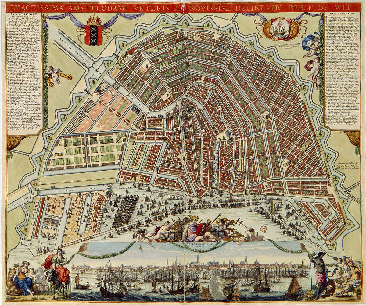
The 1688 map by Frederick de Wit is widely celebrated as the aesthetic pinnacle of 17th-century Dutch cartography. By the time De Wit published this work from his shop on the Kalverstraat, Amsterdam had reached its maximum territorial extent before the industrial revolutions of the 19th century. While earlier maps by Stalpaert or Bosch focused on the planning and defense of the city, De Wit’s map was designed as a statement of sheer civic grandeur. It captures the “Grachtengordel” (Canal Belt) in its absolute geometric perfection, reflecting a city that was not only the financial capital of the world but also its most beautifully ordered.
What truly sets this 1688 edition apart is the inclusion of a spectacular panoramic profile of the city along the bottom edge. This “Profiell” provides a stunning ground-level perspective of the Amsterdam skyline as seen from the IJ waterfront. It depicts a “forest of masts” belonging to the Dutch East India Company (VOC) and the West India Company (WIC), set against the silhouette of the city’s many church spires and the massive dome of the Ronde Lutherse Kerk. This dual perspective allowed viewers to understand the logical, mathematical layout of the streets while simultaneously marveling at the majestic, physical presence of the metropolis from the water.
Technically, De Wit’s engraving is of the highest caliber, characterized by fine lines and an incredibly balanced composition. The map meticulously renders the twenty-six defensive bastions that formed the city’s outer perimeter, each topped with a windmill. These mills were the engines of the city’s industry, and their inclusion serves as a reminder of the practical labor that underpinned Amsterdam’s luxury. De Wit also provided a detailed look at the Plantage area to the east, showing it as a series of neatly divided green plots. By 1688, this area had become a key part of the city’s identity—a “green lung” where the wealthy could stroll through botanical gardens and parks.
For historians and collectors, the 1688 De Wit map is the definitive “portrait” of Amsterdam at the very end of the Golden Age. It was frequently copied by other European mapmakers, who saw it as the gold standard for urban representation. The map often features a grand title cartouche held by the Maid of Amsterdam and Mercury, the god of trade, emphasizing that the city’s beauty was a direct result of its commercial success. Looking at this map today, one sees the Amsterdam that we still recognize—the horseshoe of canals, the dense medieval core, and the defensive line that would protect the city’s unique character for centuries to come.

Explore the Evolution of Amsterdam
The 17th-century cartography of the Dutch Republic is a testament to the city’s rapid global expansion. This post is part of our comprehensive chronological archive.
- ← Previous Map: 1679 Jacob Bosch
- Main Collection: Maps of Amsterdam: A Chronological Guide
- Next Map: → 1721 Covens & Mortier

This 1688 map by Frederick de Wit of Amsterdam is a key part of our Chronological Guide to the Maps of Amsterdam, which documents the city’s growth from a medieval port to a global capital.
Disclaimer: These works are in the public domain in their country of origin and other countries and areas where the copyright term is the author’s life plus 100 years or fewer.