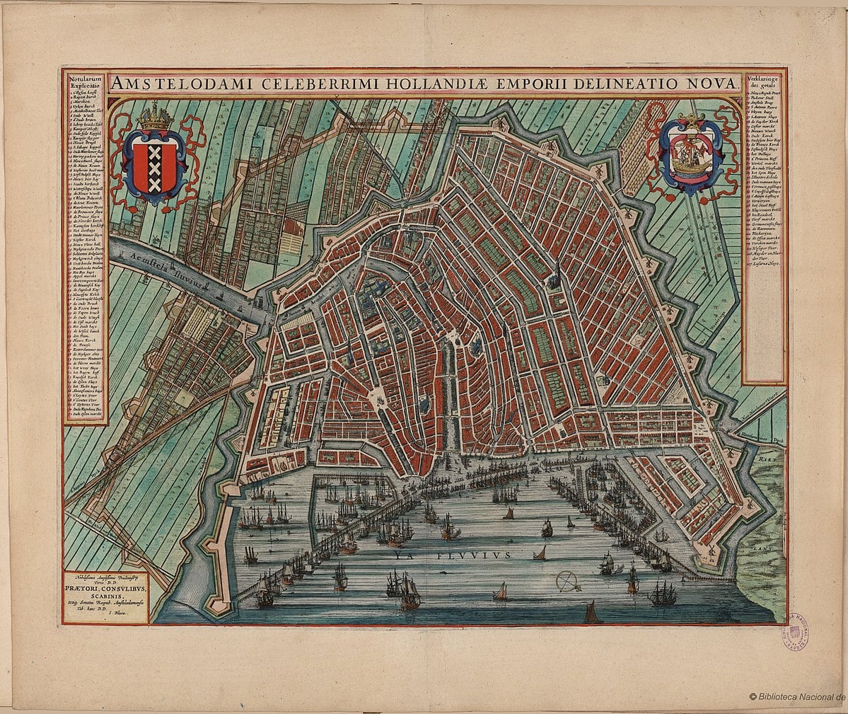
Published in 1649, the map of Amsterdam by Joan Blaeu is one of the most celebrated urban plans in history. It was a centerpiece of his monumental Toonneel der Steden (Theatre of Cities), a collection designed to showcase the power and beauty of the Dutch Republic’s urban centers. Coming just one year after the Peace of Westphalia officially recognized Dutch independence, this map was as much a political statement as it was a geographic one. Blaeu, the official cartographer of the Dutch East India Company (VOC), produced a work that radiated the confidence of a city that had become the financial and maritime capital of the world.
What distinguishes the 1649 edition is its masterful balance of technical clarity and high-art elegance. Blaeu’s map captures Amsterdam during the “Third Expansion,” showing the iconic crescent of the Herengracht, Keizersgracht, and Prinsengracht canals reaching their first major stopping point at the Leidsegracht. Unlike earlier bird’s-eye views that leaned into artistic “profiles,” Blaeu opted for a precise, top-down plan that utilized the finest copperplate engraving available in the 17th century. This allowed for a highly legible layout of the city’s streets, markets, and the twenty-six formidable bastions that protected its borders.
The map is also famous for its magnificent decorative elements. The title is often enclosed in a grand cartouche supported by allegorical figures, including the Maid of Amsterdam and Mercury, the god of commerce, signaling the source of the city’s immense wealth. Because Blaeu’s firm was the most prestigious publishing house in Europe, these maps were printed on high-quality paper and were often hand-colored for the private libraries of the global elite. It remains a definitive snapshot of the city’s “Golden Age” architecture, documenting the transition from a medieval port to a planned, symmetrical metropolis that was the envy of Europe.

Explore the Evolution of Amsterdam
The 17th-century cartography of the Dutch Republic is a testament to the city’s rapid global expansion. This post is part of our comprehensive chronological archive.
- ← Previous Map: 1625 Van Berckenrode
- Main Collection: Maps of Amsterdam: A Chronological Guide
- Next Map: → 1652 Jan Micker

This 1649 map of Amsterdam by Joan Blaeu is a key part of our Chronological Guide to the Maps of Amsterdam, which documents the city’s growth from a medieval port to a global capital.
Disclaimer: These works are in the public domain in their country of origin and other countries and areas where the copyright term is the author’s life plus 100 years or fewer.