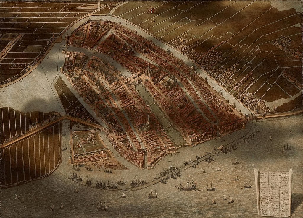
The 1652 work by Jan Micker is a unique masterpiece in the cartographic history of Amsterdam because it is not a traditional map, but rather an atmospheric oil painting that looks backward in time. While contemporary 17th-century cartographers like Joan Blaeu were focused on documenting the city’s rapid Golden Age expansions, Micker chose to recreate Amsterdam as it appeared over a century earlier. His painting is a direct homage to the famous 1544 woodcut by Cornelis Anthonisz., transforming a flat, Renaissance print into a vibrant, three-dimensional landscape.
What makes Micker’s painting so captivating is his use of light and shadow to create a sense of immense scale. He famously depicted the shadows of massive, billowing clouds casting dark patches across the city and the IJ waterfront. This artistic choice gives the viewer a true sense of the “bird’s-eye” perspective, making the city feel like a living, breathing entity nestled within the Dutch landscape. By adding color, depth, and atmospheric perspective, Micker brought the medieval wooden houses, the Gothic church spires, and the early harbor fortifications to life in a way that a monochromatic woodcut never could.
For the elite citizens of 1652, this painting served as a piece of “historical nostalgia.” It allowed the wealthy merchants living in the new, grand canal houses to look back at the humble, fortified town of their ancestors. Micker meticulously preserved the layout of 1544, including the old city walls and the monastery gardens that had long since been built over by the time he put brush to canvas. It serves as a fascinating bridge between two eras, using the sophisticated artistic techniques of the Dutch Golden Age to honor the city’s medieval roots.
Today, Jan Micker’s work is highly valued for its dual nature as both a piece of fine art and a historical document. It reminds us that even in the 17th century, Amsterdammers were deeply conscious of their city’s evolution. By reimagining the 1544 woodcut with the realism of a landscape painting, Micker created a lasting tribute to the city’s enduring character, ensuring that the Amsterdam of the past would never be forgotten by the generations of the future.
Explore the Evolution of Amsterdam
The 17th-century cartography of the Dutch Republic is a testament to the city’s rapid global expansion. This post is part of our comprehensive chronological archive.
- ← Previous Map: 1649 Joan Blaeu
- Main Collection: Maps of Amsterdam: A Chronological Guide
- Next Map: → 1657 Van Berckenrode

This 1652 work by Jan Micker of Amsterdam is a key part of our Chronological Guide to the Maps of Amsterdam, which documents the city’s growth from a medieval port to a global capital.
Disclaimer: These works are in the public domain in their country of origin and other countries and areas where the copyright term is the author’s life plus 100 years or fewer.