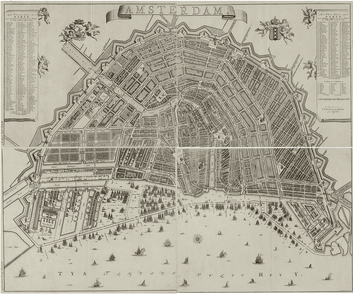
The 1782 map by Gerrit de Broen stands as one of the most definitive visual records of Amsterdam at the end of the 18th century. While earlier maps, like the famous 1544 woodcut by Cornelis Anthonisz., captured the city in its medieval infancy, De Broen’s work presents a metropolis that had reached its “completed” pre-industrial state. It is a masterpiece of Enlightenment-era cartography, prioritizing mathematical precision and urban order.
By the time this edition was published, Amsterdam had finished its final major expansion of the Golden Age. The iconic horseshoe shape of the Grachtengordel (Canal Belt) was fully realized, and the city was securely enclosed within its zigzagging line of twenty-six defensive bastions and the Singelgracht. Unlike the artistic “bird’s-eye” views of the 17th century, De Broen utilized a sophisticated top-down plan. This shift reflected a change in how people viewed the world—moving away from stylized art toward functional, accurate data.
A particularly striking feature of the 1782 map is the attention paid to the eastern districts. The Plantage area, originally intended for housing but eventually used for gardens and leisure, is shown in meticulous detail. Adjacent to it, the Oostelijke Eilanden (Eastern Islands) house the massive naval dockyards of the Admiralty and the Dutch East India Company (VOC). These details provide a snapshot of the infrastructure that allowed a relatively small city to function as a global trade hub.
Beyond the canals and docks, De Broen’s map is prized for its “uniform” rendering of the city blocks. While he included detailed elevations for major public buildings like the Paleis op de Dam and the various “Waag” (weighing) houses, the residential areas are drawn with a disciplined, rhythmic style. This creates a sense of stability and civic pride, portraying Amsterdam as a city of immense wealth that was managed with clockwork efficiency just before the radical changes of the industrial 19th century began.
The 1782 version is actually the fifth or sixth edition of a map De Broen first released in 1724. It shows a city that has reached its “completed” pre-industrial state, fully enclosed within the zigzagging line of the Singelgracht and its defensive bastions. Unlike the 1544 “birds-eye” view, De Broen opted for a more modern, top-down plan. However, he maintained a touch of the old style by including detailed elevations for public buildings, while the residential blocks are rendered with a uniform, disciplined appearance that suggests a city of order and stability.
A fascinating detail of the 1782 edition is its focus on the Plantage area and the Oostelijke Eilanden (Eastern Islands). You can see the naval dockyards of the Admiralty and the Dutch East India Company (VOC) in high detail, showcasing the infrastructure that supported the city’s global reach. De Broen even hid a personal touch in his work: in some versions, his initials “GDB” are subtly incorporated into the decorative garden patterns of the Nieuwe Plantage neighborhood.
Compared to the 1544 woodcut, this map serves as a record of a “finished” Amsterdam, capturing the city at the height of its architectural elegance just before the radical changes of the 19th century began.

Explore the Evolution of Amsterdam
The 17th-century cartography of the Dutch Republic is a testament to the city’s rapid global expansion. This post is part of our comprehensive chronological archive.
- ← Previous Map: Beyond the City Walls: The 1770 Jan Mol Map of Amsterdam
- Main Collection: Maps of Amsterdam: A Chronological Guide
This 1782 map of Amsterdam by Gerrit de Broen is a key part of our Chronological Guide to the Maps of Amsterdam, which documents the city’s growth from a medieval port to a global capital.
Disclaimer: These works are in the public domain in their country of origin and other countries and areas where the copyright term is the author’s life plus 100 years or fewer.