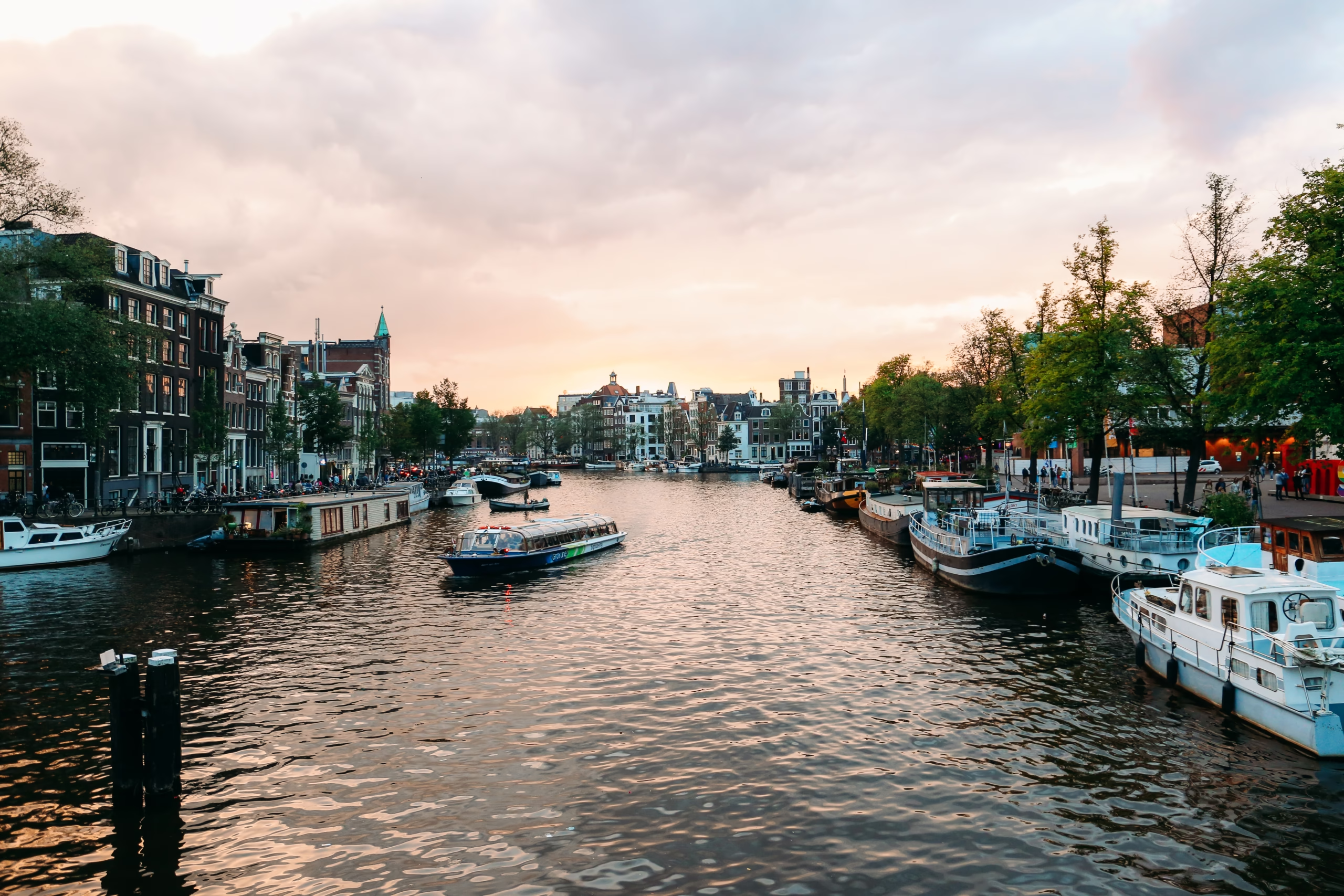
The River That Named the City
Every other waterway on this site was dug. The Amstel was here first. It is a river, canalised along much of its length, that rises south of Amsterdam in the peat country of Amstelland and once ran straight through the place where the city now stands. Amsterdam takes its name from it: the settlement grew up beside a dam in the Amstel, and the oldest surviving mention of “Amstelredam” dates from 27 October 1275.
This page follows the river through the city, from its lost mouth on the IJ to the A10 ring road, and lists every bridge that crosses it: ten crossings, from one first drawn on a map in 1544 to a railway bridge finished around 2015.
A Dam, a Harbour and a River That Lost Its Mouth
People began farming the peat along the river from around the year 1000, and Ouderkerk aan de Amstel, upstream, is probably two centuries older than Amsterdam. In the third quarter of the thirteenth century a dam was built where the river met the IJ, under today’s Dam square, and the settlement that grew around it had city rights soon after 1300.
For most of the city’s history the Amstel flowed on from the Muntplein through what is now the Rokin and the Damrak into the IJ. The Damrak was the medieval harbour, and it carried what is described as Amsterdam’s first bridge, the Oude Brug, built of timber in the early fourteenth century at the line of the present Oudebrugsteeg and demolished at the end of the nineteenth. After 1342 a second crossing, the Nieuwe Brug, was built at the mouth on the IJ. It survives as bridge 303, part of the Prins Hendrikkade.
That lower course is no longer called the Amstel. The stretch of the Rokin between the Spui and the Dam was filled in two stages, in 1933 and 1936, and the end of the Damrak nearest the Dam is dry land too: the Beurs van Berlage and the Bijenkorf stand on it. Officially the river now ends at the Muntplein, though culverts under the Rokin and the Dam still carry some of its water to the Damrak and the IJ.

How the River Came Inside the Walls
Until the 1660s the city’s edge crossed the Amstel near the Blauwbrug. The Fourth Expansion, laid out from 1662, carried the canal ring across the river to the east and brought the stretch between the Blauwbrug and the new city wall inside Amsterdam. The irregular banks were straightened and given quay walls, and where the new wall crossed the water the city built the Hogesluis in 1662, a 220-metre bridge at rampart height.
The expansion created a water problem. The Amstel was a tidal river, and the enlarged ring of canals was becoming foul. In 1673 the mathematician and burgomaster Johannes Hudde designed and built the Amstelsluizen, a set of locks between the Prinsengracht and the Singelgracht, to manage the flow and flush the canals. The locks still stand by the Carré theatre and are a rijksmonument (national monument, number 518510). Normally they stand open. The Prinsengracht page explains how they made a generation of inner sluices redundant.
Beyond the wall the river ran through countryside lined with the country houses of rich Amsterdammers, three of which survive along the Amsteldijk. In the twentieth century the city grew south and the Amstel between the Omval, by Amstel station, and the Hogesluis became an urban river. In the dry summer of 2003 its flow was deliberately reversed for the first time, pumping water from the IJmeer south towards South Holland.
The River Today
Inside the old city the river is lined by a street simply called Amstel, which runs from the Muntplein, turns south at the Stopera and ends at the Hogesluis. Its landmarks are theatrical: De Kleine Komedie, built in 1786 as a French theatre; the Amstelhof, a home for the elderly from 1681 and the H’ART Museum since 2023; and Carré, opened as a circus in 1887. For decades the northern stretch was also a centre of Amsterdam’s gay bars, the last of which, the Amstel Taveerne, closed in 2024.
Further south the Amstel is a working and sporting river, used by commercial shipping and by rowers, who race on it in regattas such as the Head of the River Amstel. It has drawn painters from Rembrandt to Breitner and Mondrian.
Doelensluis and Halvemaansbrug: Where the River Begins
The first crossing on the river as it now stands is the Doelensluis, bridge 220, where the Amstel becomes the Rokin. A bridge has stood here at least since 1544, when Cornelis Anthonisz. drew one on his map; it was painted red in 1597 and rebuilt in stone in 1663. The present bridge, by Piet Kramer, is dated “Anno 1935” and opened in September 1936. (“Sluis” is the old Amsterdam word for a stone bridge, not a lock.)
Immediately beside it the Muntplein itself is a bridge: bridge 1, the Muntsluis, which carries the square over the mouth of the Singel where it joins the Amstel. It spans the Singel, not the river.
A short way east, the Halvemaansbrug (Half Moon Bridge), bridge 221, links the Kloveniersburgwal side to the Halvemaansteeg. The first bridge was probably built in 1626. Kramer’s plate bridge of 1939 to 1940 has sea-creature keystones, and, unusually for Amsterdam, its name is cut into two of them rather than fixed to the railings. Nobody agrees where the name comes from: an early bridge shaped like a half moon, the half-moon bastion where the Hotel de l’Europe now stands, or a tavern called De Halve Maan. All three explanations circulate, and none is proven.
Blauwbrug: The Bridge That Tried to Be Parisian
Bridge 236, the Blauwbrug (Blue Bridge), carries the Amstelstraat over the river to the Waterlooplein. It takes its name from earlier timber drawbridges here whose woodwork was painted blue. The present bridge was opened in 1883, designed by the city architects Bastiaan de Greef and Willem Springer. The city wanted a bridge that would carry trams and impress visitors to the International Colonial Exhibition held in Amsterdam that year, and got eight granite pylons topped with imperial crowns, ornate lanterns and solid piers. Critics found it too pompous for Amsterdam as soon as it opened. It is a rijksmonument (518352).
Both the monument register and Dutch Wikipedia connect the design to the Pont Alexandre III in Paris, the register more cautiously (“possibly inspired by”). The comparison cannot be right as a source of inspiration: the Pont Alexandre III was built between 1896 and 1900, thirteen years after the Blauwbrug opened. In 1938 and 1939 Piet Kramer replaced the iron girders with concrete and simplified the look; a restoration in 1999 reversed his changes and gave the bridge back its blue.
The Blauwbrug was the way into the Jodenbuurt, the Jewish quarter, and in Yiddish it was the Bloubrik, a name that turns up in sayings about never escaping where you come from. During the occupation the German occupier, with substantial assistance from the Amsterdam municipal police for the round-ups, deported the Jews of Amsterdam. Of about 80,000 Jews living in the city in 1941, around 60,000 were murdered, the highest proportion in Western Europe. Most were taken from the Hollandsche Schouwburg assembly point to Westerbork, and from there to Auschwitz and Sobibor. The demolition of much of the old quarter in the decades after the war came after the murders and as a consequence of them. The names of the murdered, and the addresses they were taken from, are recorded at the Joods Monument. The Stopera, the city hall and opera house, now stands on the Waterlooplein at the end of the bridge.
Magere Brug: What the Name Really Means
No bridge in Amsterdam attracts more invented history than bridge 242, the Magere Brug, the “Skinny Bridge” between the Kerkstraat and the Nieuwe Kerkstraat. The best known story says two thin, miserly sisters paid for it, and the romantic legends told from tour boats have grown up around it since. Dutch Wikipedia, drawing on J.E. Abrahamse’s history of the Fourth Expansion, is blunt: the anecdotes that circulate about the bridge arose because its real history was forgotten, and they are all fantasy.
The real explanation is economic. The plan of 1662 drew a broad stone bridge here to carry the Kerkstraat across the river. Then came the disaster year of 1672, when the Republic was invaded and the economy collapsed. Demand for building plots on the far bank evaporated, the Nieuwe Herengracht, Nieuwe Keizersgracht and Nieuwe Prinsengracht stayed largely empty, and the bridge was not built. When some building did arrive at the end of the century, the city put up a crossing after all, in timber rather than stone and much narrower: “magerder”, skinnier.
That first bridge, the Kerkstraatbrug, was built in or shortly after 1691 to a design by Hans Jansz van Petersom. Sources differ on what followed. Dutch Wikipedia gives it thirteen openings from the start, replaced in 1871 by a bridge of nine designed by Wichert Arend de Graaf; the monument register says it became a double drawbridge with thirteen openings in 1840 and was reduced to nine in 1871. Both agree that Piet Kramer drew modern designs, that the council insisted on a copy of the old bridge, and that the replica was finished in 1934, with steel girders on concrete piles behind timber cladding. It is Kramer’s bridge, and shows almost none of his style.

Until 1994 two bridge-keepers raised and lowered it by hand, using their own weight on the deck to control the speed, until the labour inspectorate judged this too dangerous. Cars used it until 2003. It is a rijksmonument (518383), the setting of a concert every Liberation Day, and a location in the James Bond film Diamonds Are Forever.
Hogesluis: The Bridge on the Ramparts
South of the Amstelsluizen, bridge 246, the Hogesluis, carries the Sarphatistraat between Carré and the Amstel Hotel. When it was built in 1662 it joined the city ramparts on either side of the river at their own height, about six metres, which is why it was soon called the “Hooge Sluis”, the high bridge. It had 35 stone arches, eleven of them over the river. In 1823 the middle arches gave way to bascule leaves, and in 1875 the deck was lowered by more than a metre for the city’s first horse tram.
In 1882 and 1883 Willem Springer built a new bridge on the seventeenth-century piers, with obelisks, lanterns and a stone vase balustrade, for the fashionable district around the Amstel Hotel. Dutch Wikipedia says its model was the Pont Neuf in Paris. When the foundations failed in the 2000s the stonework was dismantled, new piers were built, and the facing went back on. The bridge reopened on 15 July 2012, its 350th year, at a total cost of 27 million euros. It is a rijksmonument (518386).
Torontobrug and Nieuwe Amstelbrug
Beyond the Singelgracht the bridges were built for the expanding city. Bridge 350, the Torontobrug, carries the Stadhouderskade across to the Mauritskade. Discussed from the early 1950s and delayed for years, it opened on 23 October 1969, designed at Publieke Werken by Gerrit Feiko Janssonius (engineering) and Dick Slebos (form). It was first called the Stadhoudersbrug, a name Amsterdammers already used for another bridge, and on 2 October 1974 David Crombie, mayor of Toronto, renamed it to seal the two cities’ twinning.
Bridge 101, the Nieuwe Amstelbrug, carries the Ceintuurbaan over the river. It was designed by Hendrik Petrus Berlage, with Hendrik Leguyt of Publieke Werken responsible for the mechanism, and opened on 5 July 1903, replacing a ferry. By the 1970s the steel was worn out. Dirk Sterenberg designed a diagonal replacement, but the neighbourhood wanted Berlage’s bridge kept, and between 1983 and 1986 it was rebuilt to the original design in modern materials. It reopened on 12 April 1986, when an elephant was led across to show how strong it was.
Berlagebrug: The Gateway From the South
Bridge 423, the Berlagebrug, was originally called the Amstelbrug. It links the Vrijheidslaan in the Rivierenbuurt with the Mr. Treublaan, and was planned as the eastern exit of Berlage’s Plan Zuid. Berlage designed its architecture, and the engineering was by Wichert Arend de Graaf and then Cornelis Biemond of Publieke Werken. It opened on 28 May 1932. At the time, according to Dutch Wikipedia, its 80 by 24 metres made it the largest bridge in Amsterdam. On the city side of its tower is Hildo Krop‘s four-metre ceramic Genius of Amsterdam, rising crowned from the water. The bridge and its quays, railings and boathouses were designated a rijksmonument together with the Schollenbrug in 2008 (530055).
The Berlagebrug is where Amsterdam’s liberation arrived: on 8 May 1945 a large Canadian force entered the city over this bridge.

Utrechtsebrug and Rozenoordbrug: Where This Page Stops
Bridge 439, the Utrechtsebrug, was built from 1951 for the new motorway to Utrecht and opened to all traffic on 3 July 1954. It was Piet Kramer’s design, repeatedly cut back for cost; prestressed concrete, with help from the French engineer Eugène Freyssinet, reduced the piers from four to two, and a five-metre clearance made an opening span unnecessary. On one of its piers hangs a sabbath chain given by the Nederlands-Israëlitische Gemeente, the Jewish community: it symbolically closes the river so that the city counts as an eruv, an enclosed area within which carrying on the sabbath is permitted.
The last crossing covered here is the Rozenoordbrug, where the A10 ring road crosses the river. It is a group of bridges: two road bridges of 1981 and 1989, numbered 174P, with a metro bridge (1638, opened 1990) and two railway bridges (1993 and about 2015) between them, all named after the vanished country house Rozenoord. Beside it is the Rozenoord execution site, where the German occupier shot an estimated 140 people on nine days between 18 September 1944 and 14 April 1945, a hundred of them known by name.
This page draws its line at the ring road. South of the Rozenoordbrug the river leaves the city for Ouderkerk aan de Amstel and the bridges belong to Amstelland rather than Amsterdam. North of the Doelensluis the old riverbed is the Rokin and the Damrak, which are no longer counted as the Amstel.
The Bridges Across the Amstel
From the centre southwards, ten crossings:
- Bridge 220: Doelensluis, Nieuwe Doelenstraat to the Muntplein (Piet Kramer, 1936)
- Bridge 221: Halvemaansbrug, Kloveniersburgwal to the Halvemaansteeg (Piet Kramer, 1939 to 1940)
- Bridge 236: Blauwbrug, Amstelstraat to the Waterlooplein (De Greef and Springer, 1883)
- Bridge 242: Magere Brug, Kerkstraat to the Nieuwe Kerkstraat (rebuilt 1934)
- Bridge 246: Hogesluis, Sarphatistraat (1662, rebuilt 1883 and 2009 to 2012)
- Bridge 350: Torontobrug, Stadhouderskade to the Mauritskade (1969)
- Bridge 101: Nieuwe Amstelbrug, Ceintuurbaan (Berlage, 1903, rebuilt 1986)
- Bridge 423: Berlagebrug, Vrijheidslaan to the Mr. Treublaan (Berlage, 1932)
- Bridge 439: Utrechtsebrug, Rijnstraat to the Nieuwe Utrechtseweg (Piet Kramer, 1954)
- Rozenoordbrug: A10 road bridges (174P), metro bridge (1638) and railway bridges (1981 to about 2015)
Bridges on the Amstel, Not Over It
Several of the river’s best-known bridges cross the canals that run into it rather than the river itself. On the west bank, where the canal ring meets the Amstel, three bridges close the ends of the great canals: bridge 35 over the Herengracht, bridge 36 over the Keizersgracht and bridge 76 over the Prinsengracht. Further south, bridge 77 crosses what is left of the Achtergracht. The Four Men Who Planned the Canal Ring explains the names these four bridges carry.
Every bridge documented so far is listed in the bridge index, by number, by name and by canal.
Sources Consulted
- Amstel (rivier), Nederlandstalige Wikipedia
- Amstel (straat), Nederlandstalige Wikipedia
- Lijst van bruggen in Amsterdam, Nederlandstalige Wikipedia
- Rokin (straat), Damrak and Oude Brug (Amsterdam), Nederlandstalige Wikipedia
- Amstelsluizen, Nederlandstalige Wikipedia
- Doelensluis, Halvemaansbrug, Muntsluis, Nederlandstalige Wikipedia
- Blauwbrug and Pont Alexandre-III, Nederlandstalige Wikipedia
- Magere Brug, Nederlandstalige Wikipedia
- Hogesluis, Torontobrug, Nieuwe Amstelbrug, Nederlandstalige Wikipedia
- Berlagebrug, Utrechtsebrug, Rozenoordbrug, Nederlandstalige Wikipedia
- Fusilladeplaats Rozenoord, Nederlandstalige Wikipedia
- Jodenbuurt (Amsterdam), Nederlandstalige Wikipedia
- Joods Monument
- Rijksmonumentenregister: Blauwbrug (518352), Magere Brug (518383), Hogesluis (518386), Schollenbrug and Berlagebrug (530055), Amstelsluizen (518510)
- J.E. Abrahamse, De grote uitleg van Amsterdam (2nd edition 2011), Thoth (as cited by Nederlandstalige Wikipedia)
- Frank V. Smit, Bruggen in Amsterdam (2008), Matrijs
- Sebas Baggelaar and Pim van Schaik, Piet Kramer, Bruggenbouwer van de Amsterdamse School (2016), Stokerkade
- Featured image: the Amstel seen from the Blauwbrug, Richard Broekhuijzen, 2017, CC BY-SA 4.0