Bridge number 1 (Brug 1) The Muntsluis. This may not be the first bridge in Amsterdam but it’s number one. When the bridges were numbered it made sense to start at the central point of Amsterdam’s web-like Canal network. Zoom in on the first picture and you can see the number painted in the middle of the bridge span.


It’s a fixed bridge and clearly used to be a lock as it still bears the name sluis not brug.
Muntplein (Mint square) is actually the bridge span over the Singel canal. If you’ve ever been to the famous Amsterdam flower market then you’ve likely crossed over this bridge.
The bridge is located over the place where the Singel flows into the Amstel . The bridge forms the connection between the east quay of the Singel, the Kalverstraat , the Rokin , the west quay of the Amstel, the Reguliersbreestraat and Vijzelstraat . The traffic intersection bears the name Muntplein. North of the bridge is the Munt (Mint), the namesake of the bridge and square. The statue of Lady Fortuna by Hildo Krop has been on the bridge since 1972, except for the period when it was stolen.
Architects
1915: J.M. van der Mey
1939: Piet Kramer
A Square That Is a Bridge (and a Bridge That Is a Square)
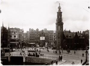
Stand at the Muntplein on a bright morning and you might reasonably think you are in one of Amsterdam’s more modest city squares: a broad, open expanse of stone paving where six streets converge, trams clang past, cyclists weave between tourists consulting their maps, and the elegant silhouette of the Munttoren rises against the sky like a reminder of everything that has come before. You would not be wrong about any of this. But you would be missing the most extraordinary fact about the place beneath your feet: you are standing on a bridge.
Not a bridge in the conventional, narrow sense of the word. The Muntsluis, officially designated Bridge Number 1 in Amsterdam’s municipal numbering system, is the widest bridge in the entire city. Beneath the broad stone plaza, beneath the tram tracks and the bicycle lanes and the worn paving stones, the waters of the Singel canal flow quietly into the Amstel river, just as they have done for more than five centuries. The bridge does not announce itself. It simply absorbs everything that the city requires of it, and has done so, in one form or another, since the late fifteenth century.
The engineering that allows a structure to carry a bustling six-way intersection, tram tracks, and thousands of daily pedestrians is a matter of progressive expansion. The Muntsluis achieved its current colossal width through a series of widenings over the centuries, each generation of city builders extending the platform to accommodate the growing demands of urban traffic. The most significant of these expansions, as we shall see, came in the late 1930s. But the story begins much earlier, at a gate in Amsterdam’s medieval city wall.
In the above image you can clearly see the canal running under muntplein.
The Regulierspoort and the Origins of Bridge 1
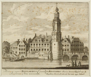
The land beneath Muntplein was, in the fifteenth century, the edge of the world as Amsterdam knew it. The city was growing rapidly, pushing its walls outward in concentric expansions, and in the years between 1480 and 1487 the municipality constructed the Regulierspoort, one of the three principal gates in the medieval city wall. Like most defensive gates of the period, the Regulierspoort was an imposing structure: two towers flanking a central gatehouse, with a narrow passageway between them for the movement of people and goods. Beside it, a slender wooden bridge crossed the water at the point where the Singel met the Amstel, connecting the city to the meadows and farmland beyond the walls.
The gate bore the name “Reguliers” in reference to the Augustinian canons, the Reguliere Kanunniken, whose monastery stood nearby. For over a century it served its function as a gateway and checkpoint, until Amsterdam’s second great expansion made the old city wall redundant. The wall was demolished to make way for new streets and buildings; a glassworks appeared on the site in 1613, followed by a guardhouse in 1616. The gate itself, stripped of its defensive purpose, had already begun its long transformation into something else entirely.
The decisive moment came in 1618. A fire broke out in the glassworks and consumed most of what remained of the Regulierspoort complex: the old gatehouse, the watchtower, and the houses that had grown up between the structures. When the smoke cleared, only a fragment of the original gate survived: the lower section of one tower, standing alone beside the water. That fragment would become the base of the Munttoren, the Mint Tower, which dominates the Muntplein to this day.
Hendrick de Keyser and the Tower That Stands
In 1620, just two years after the fire, Amsterdam’s celebrated city architect Hendrick de Keyser was commissioned to make something of the surviving tower stump. De Keyser, already famous for churches like the Westerkerk and the Zuiderkerk, brought his characteristic Amsterdam Renaissance sensibility to the task. He raised an octagonal brick section atop the medieval base, crowned it with an elegant open spire of painted wood, and installed a clock with four faces and a carillon of bells. The result was a tower that managed to look both ancient and contemporary, a quality that the Dutch have always prized.
The carillon was eventually upgraded in 1669 by Pieter Hemony, one of the celebrated Hemony brothers, who brought his expertise in precisely tuned bell casting to the instrument. The Hemony brothers had already installed bells in the Amsterdam Stock Exchange in 1651, and their work at the Munttoren was similarly exacting: the tower now houses 38 bells, and a mechanical drum created by Pieter Hemony still causes them to chime every quarter hour.
The Name: Munt, Sluis, and a Pleasing Linguistic Mystery
The name “Muntsluis” repays a little investigation, because both of its components contain surprises.
The word munt (mint) reflects an episode that was brief but historically vivid. In the catastrophic year of 1672, known in Dutch history as the Rampjaar or “Year of Disaster,” the Dutch Republic found itself simultaneously at war with England and France. French forces occupied large portions of the country, and the established minting cities of Dordrecht and Enkhuizen were cut off from the circulation of precious metals. In this emergency, the guardhouse attached to the Munttoren was pressed into temporary service as a coin-minting facility. The arrangement lasted only a few years, but it was long enough to give the tower its permanent name, and through the tower, the square and the bridge beneath it inherited the same designation.
The word sluis (sluice, or lock) is the more intriguing component. A visitor today will find no lock at Muntplein: the water beneath the bridge flows freely, unimpeded by any gate or mechanism. Yet the structure is called a “sluis” and not a “brug” (bridge). This is because, in older Amsterdam Dutch, the word sluis was routinely applied to stone bridges, particularly those that replaced earlier wooden crossings or those associated with water management infrastructure. When the narrow wooden crossing at this location was replaced with a more substantial stone structure, it acquired the designation sluis as a matter of local convention, even though there was no functioning lock involved. The nearby Doelensluis bears the same etymological imprint. It is, as these things tend to be in Amsterdam, a small fact that opens a window onto a much older city.
The Number That Is Not First
Bridge Number 1 is not the oldest bridge in Amsterdam, nor was it the first to be built. The numbering system was introduced in the modern era as a practical administrative tool for a city with more than 1,200 bridges, and the Muntsluis was assigned the number 1 because it occupies the geographical and conceptual center of Amsterdam’s canal network. From this point, the bridge numbers increase consecutively as they sweep northward along the Singel, around the Herengracht, and back along the Keizersgracht: a radiating system that treats the Muntsluis as its zero point. It is, in other words, the origin of the city’s official counting of itself.
Jo van der Mey and the Amsterdam School Bridge
By the early twentieth century, the bridge at Muntplein had been widened several times from its medieval dimensions, but it was the commission of 1915 that gave it its lasting architectural character. The designer was Joan (Jo) Melchior van der Mey (1878-1949), a figure of outsized importance in Amsterdam’s architectural history.
Van der Mey had trained under Eduard Cuypers and won the prestigious Dutch Prix de Rome in 1906, after which he was engaged by the city as its “Aesthetic Advisor.” This was a role that suited him precisely, because van der Mey was not simply a builder but a theorist of the urban environment, a man who believed that every element of the streetscape, from the largest facade to the smallest lamp post, should be part of a coherent artistic vision.
His great early commission was the Scheepvaarthuis (Shipping House, begun 1912), a building generally credited as the founding text of the Amsterdam School movement. The Amsterdam School, which flourished roughly between 1915 and 1930, was characterized by expressive brickwork, organic ornamental details, sculptural facades, and a rejection of the austere rationalism that was simultaneously emerging in other parts of Europe. It was, in its own way, a total art philosophy: architects designed not just buildings but bridges, street furniture, and decorative ironwork, all in a style that was unmistakably Dutch and unmistakably of its moment.
The Muntsluis that van der Mey designed and that was completed in 1917 reflected these principles. The bridge incorporated decorative stonework in the expressive idiom of the Amsterdam School, with the kind of sculptural attention to ornamental detail that his colleagues Michel de Klerk and Piet Kramer were simultaneously bringing to social housing projects across the city. A small bridge house (the kind that served, in this location, as a post for traffic police overseeing the convergence of six streets) was integrated into the design with characteristic care, its modest dimensions belying the architectural ambition applied to it.
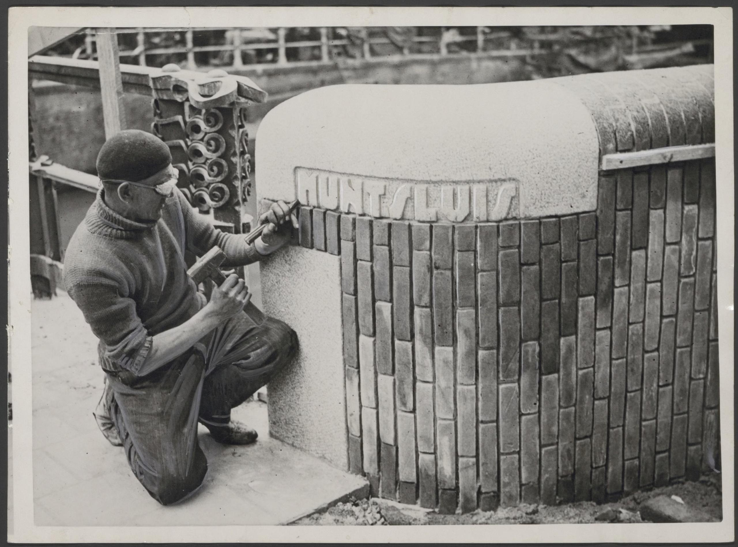
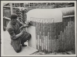
Piet Kramer and the Great Widening
If van der Mey gave the Muntsluis its architectural identity, it was Piet Kramer (1881-1961) who gave it its present scale. In 1938 and 1939, Kramer oversaw the widening of the bridge to its current extraordinary proportions, the intervention that transformed a wide bridge into effectively a city square.
Kramer was, by this point, Amsterdam’s foremost bridge architect, a man who had spent decades designing and rebuilding the city’s crossings in a style that combined Amsterdam School expressionism with civic pragmatism. He had collaborated with van der Mey on the Scheepvaarthuis, and like his colleague he shared the conviction that infrastructure could be architecture. His bridges are distinguished by their wrought-iron railings, their stone sculptures, and the quality of attention paid to surfaces that most designers would have treated as purely functional.
The widening of the Muntsluis was a substantial engineering undertaking, requiring the extension of the bridge’s platform across the full width required to accommodate the traffic demands of a city that had grown enormously since 1917. Kramer’s intervention preserved the essential character of van der Mey’s original while scaling it up to meet the demands of modern Amsterdam. The result is the structure we see today: the widest bridge in the city, broad enough to function as a public square while still being, at its heart, a bridge.
The Flower Market at the Edge of the Bridge

One of the most serendipitous geographical facts about the Muntsluis is what lies immediately to its west. The Bloemenmarkt, the world’s only floating flower market, stretches along the Singel canal between Muntplein and Koningsplein. Established in 1862, when flower growers from the surrounding countryside would moor their barges along the canal and sell directly from the water, the market today occupies a series of large pontoon platforms attached firmly to the canal bank. (The “floating” designation is somewhat technical at this point: the stalls are fixed in place, and the floating is more a matter of heritage than hydraulics.)
The Bloemenmarkt’s eastern terminus is, in effect, the Muntsluis. Visitors who have walked the length of the market, past the tulip bulbs and the wooden clogs and the extravagant tourist souvenirs, arrive at Muntplein and find themselves suddenly on the widest bridge in Amsterdam, with the Munttoren rising before them and six streets radiating outward in every direction. It is one of the city’s more satisfying urban transitions: the intimate scale of the canal market giving way, in a few steps, to the broad civic openness of the square-bridge.
The Rode Loper and the Modern Muntplein
For much of the twentieth century, Muntplein was, despite its historic character, something of an urban problem: a complicated intersection where trams, cars, cyclists, and pedestrians competed for space in conditions that were, by any reasonable measure, chaotic. The convergence of six streets and multiple tram lines at a single point was always going to create friction.
The transformation began in 2017, when the city included Muntplein in the ambitious “Rode Loper” (Red Carpet) project. The Rode Loper was conceived as a pedestrian and cycling priority corridor running south from Central Station along the route of the new Noord-Zuidlijn (North-South Metro, Line 52), which opened in July 2018. The philosophy was straightforward: now that a metro line ran directly beneath the city’s busiest north-south axis, the surface streets could be reclaimed from motor traffic and given over to slower, more human-scaled movement. At Muntplein, a section of tram track was rebuilt from double track to single track, freeing up significant pavement width for pedestrians and cyclists.
The Rode Loper was followed by the related Oranje Loper project (launched from 2023), which extended the same pedestrian-priority logic to parallel corridors. Together, these interventions have dramatically changed the character of Muntplein: where once a never-ending tangle of vehicles made the square feel more like a junction than a place, it now functions, increasingly, as the city square it has always technically been.
Trams at Muntplein Today
As of 2025, the tram lines serving Muntplein and the immediately adjacent Rokin area are lines 4 and 14. Both run between Centraal Station and Rembrandtplein, passing through Dam Square and along the Rokin before arriving at Muntplein.
Tram 14 follows a longer route, continuing east from Rembrandtplein through the Plantage district and into Amsterdam-Oost via Zeeburgerdijk. Tram 4 provides a more direct corridor between the station and the southern part of the city centre.
Tram line 24, which previously ran the full length of Vijzelstraat from Centraal Station, was truncated in November 2023 and now terminates at Frederiksplein, considerably south of Muntplein. The reduction in surface tram traffic along Vijzelstraat reflects the success of Metro 52 beneath it: the underground line covers the same north-south corridor in four minutes, with a stop at Rokin that places passengers a short walk from the bridge. For visitors approaching from the north, the metro station at Rokin is now typically the most direct route to Muntplein on foot.
Standing on Bridge Number 1
The Muntsluis repays more than a glance. Most visitors to Amsterdam pass across it without registering what it is, drawn forward by the Munttoren or the flower market or the tram that has just arrived. But the bridge rewards the visitor who pauses to look down at the water flowing beneath the paving, to trace the decorative stonework that van der Mey introduced in 1917 and that Kramer preserved in his 1939 expansion, or to consider the improbable continuity of this place: a fifteenth-century city gate, a seventeenth-century mint, an Amsterdam School bridge, a twenty-first-century pedestrian priority square, all layered on top of one another at the precise point where the Singel meets the Amstel.
It is Bridge Number 1 not because it was built first, but because it is the center: the place from which all other bridges, and in some sense all of Amsterdam, are counted. To stand on it is to stand at the origin point of a numbering system that encompasses more than 1,200 crossings and stretches to every corner of a city built, in the most literal sense, on water.
Research compiled February 2026. Sources consulted include the Amsterdam city information portal (DutchAmsterdam.nl), the Bridges of Amsterdam archive (bridges.cramberts.com), Wikipedia entries on the Munttoren, Amsterdam School architecture, and Amsterdam tram lines, and GVB public transport information. For primary source research, the Stadsarchief Amsterdam (Amsterdam City Archives) holds extensive photographic and documentary records relating to the Muntsluis, including drawings from the van der Mey and Kramer commissions.
Key Facts at a Glance
Official name: Muntsluis Bridge number: 1 (Brug 1) Location: Muntplein, where the Singel meets the Amstel Status: Widest bridge in Amsterdam Streets connected: Singel (east quay), Kalverstraat, Rokin, Amstel (west quay), Reguliersbreestraat, Vijzelstraat Historical predecessor: Regulierspoort (city gate), 1480-1487 1618: Fire destroys the Regulierspoort; Munttoren base survives 1620: Hendrick de Keyser rebuilds the tower in Amsterdam Renaissance style 1672: Munttoren guardhouse temporarily used as a coin mint (Rampjaar) 1915/1917: Bridge redesigned by Jo van der Mey (Amsterdam School) 1938/1939: Bridge widened by Piet Kramer to current dimensions 2017/2018: Rode Loper project prioritizes pedestrians and cyclists Current tram lines: 4 and 14 Adjacent landmark: Bloemenmarkt (eastern terminus at Muntplein) “Sluis” note: Term historically applied to stone bridges in Amsterdam; no functioning lock exists here today


See also

