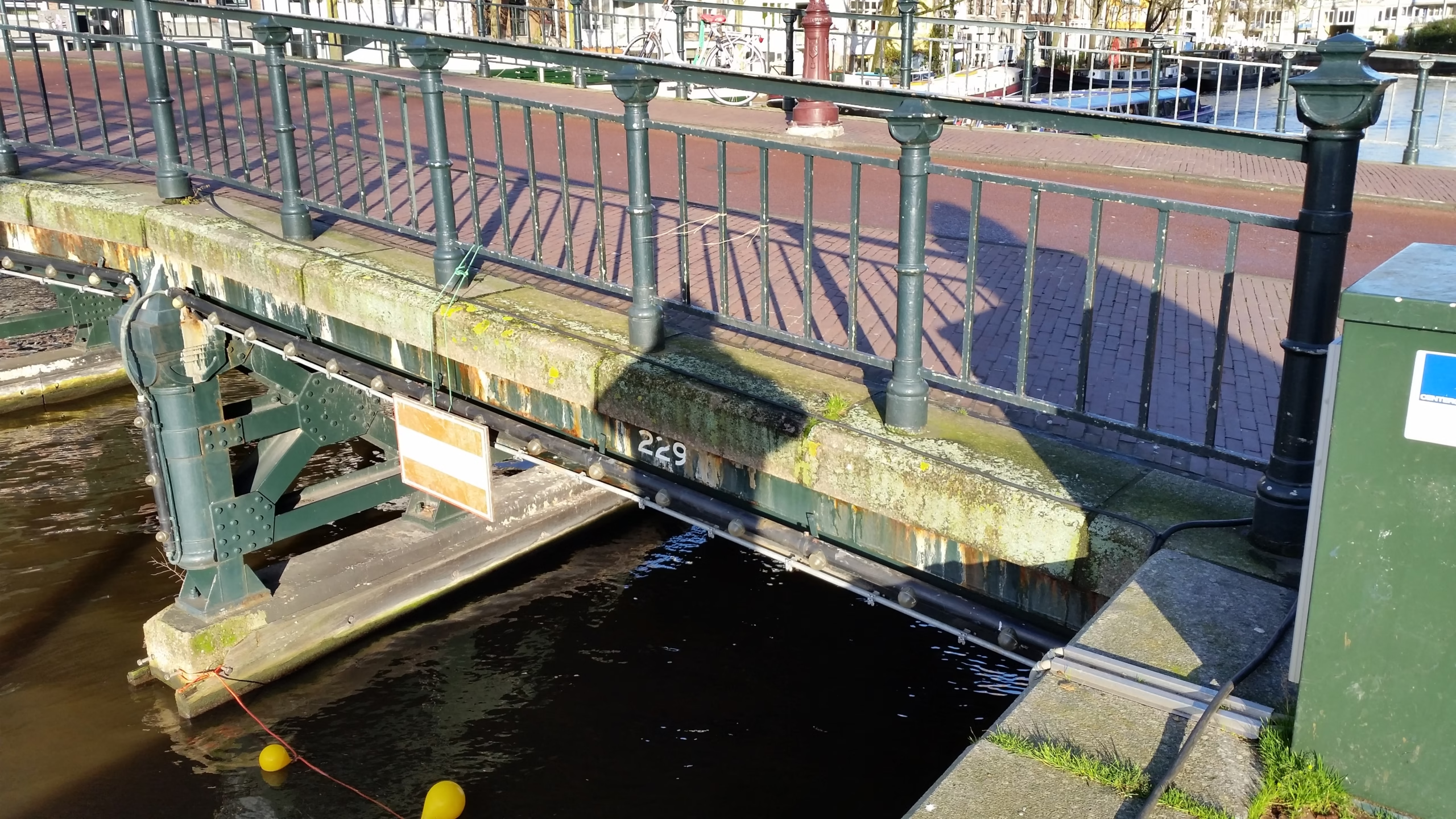
A Number on Every Bridge
Look along the side of almost any bridge in Amsterdam and you will find a number. On the older canal bridges it is usually painted in white on the stonework or the steel, on later ones it sits on a small plate between the railings, and on a few modern bridges it is built into the structure itself. Every bridge the city looks after carries one. Most carry nothing else: for most of the twentieth century the number was the only name the great majority of Amsterdam’s bridges had.
This site is organised around those numbers, and How many bridges Amsterdam actually has explains why the highest number is not a count. This article is about the system itself: where it starts, how the numbers were handed out, what the letters after some of them mean, and the many places where the register, the map and the plate on the bridge do not agree.
Bridge 1 Is at the Munt
The sequence begins at the Muntsluis, the broad crossing at the Muntplein where the Singel meets the Amstel. It is not the oldest bridge in the city. The Oude Brug over the Damrak, built in the early fourteenth century, has that distinction, and it carries number 47. Bridge 1 is simply where the counting starts. From the Munt the numbers run along the Singel, through the canal ring and then outward, district by district, roughly in rings towards the suburbs.
The register belongs to the municipality. For most of its history it was kept by the Dienst der Publieke Werken, the city’s Public Works department, whose drawing archive, now in the Stadsarchief, files its bridge dossiers under these numbers. No source this site has found gives a date for the first numbering. The earliest firmly dated evidence in the sources used here is a municipal maintenance specification of 1913, the onderhoudsbestek voor beweegbare en vaste bruggen (maintenance contract for movable and fixed bridges), which several Wikipedia articles use to show which number a bridge carried by then. Number 334, for example, belonged to a footbridge beside a railway bridge from 1913.
Today the numbers live on in the city’s bridge lists and maps, and they sit alongside the official names in the Basisregistratie Adressen en Gebouwen (BAG), the national register of addresses and buildings, which is where the city records each named bridge.

Numbers Given in Blocks
Once the city spread beyond its seventeenth-century limits, numbers were issued in series as new areas were built, and the series still tell you roughly where and when a bridge belongs. The bridges Piet Kramer designed for the Amsterdamse Bos from the late 1930s were numbered in the 500s, a run that ended at 595. Bridges 682, 683 and 684 by the Rembrandtpark were built in 1973 and 1974. In the Bijlmermeer, the standard foot and cycle bridges that Dirk Sterenberg designed from 1968 make up a whole family in the 1140s. The viaducts of the metro, begun in the early 1970s, sit mainly in the 1600s.
The round numbers are milestones rather than counts. Bridge 2000 is the Jan Schaeferbrug over the IJhaven. The bridges of IJburg start at 2001 with the Enneüs Heermabrug, opened in 2001; the internal bridges of the Java-eiland use 1983 to 1995; the Nescio Bridge is 2013 and the Oosterdoksdraaibrug 2270. A handful of metro and railway viaducts carry numbers in the 9000s.
The clearest proof that a number is not a position in a count is the bridge that was officially opened as the thousandth. On 2 April 1974 the alderman Han Lammers opened the Duizendste brug, the Thousandth Bridge, over the Postjeswetering by the Rembrandtpark. Its number is 684. Amsterdam already had more than a thousand bridges at the time; the title only worked because bridges in private, provincial and national hands were left out of the total. Bridge 1000 is somewhere else entirely, in Amsterdam-Noord.
P, S and Other Letters
Some bridges carry a letter after the number, and the letter changes everything. A P marks a bridge that Amsterdam does not manage itself. Sources describe it slightly differently: as maintenance by a third party, as management by the state or the province, or simply as “not managed by Amsterdam”. Peter Korrel, who has photographed every numbered bridge in the city, defines P-bridges as those owned by private parties, Rijkswaterstaat (the national roads and waterways agency), the provincial waterways service or the water boards, and counts at least 98 of them alongside at least 2,073 bridges with an ordinary number.
P-numbers form their own series, so they repeat ordinary numbers without any connection between the two. The Amsterdamsebrug, the arch bridge over the Amsterdam-Rijnkanaal on the Zuiderzeeweg, is 54P, while bridge 54 is the Noordsche Compagniebrug on the Keizersgracht. The Schellingwouderbrug over the Buiten-IJ is 55P. The Rozenoordbrug, which carries the A10 ring road over the Amstel, is 174P; plain 174 is the Leidsebrug on the Singelgracht. The Sloterbrug over the Ringvaart between Sloten and Badhoevedorp belongs to the municipality of Haarlemmermeer, officially has no name, and is known in Amsterdam as 9P. The Dijkzichtbrug, a cycle bridge over the A2 in Ouder-Amstel, is 205P.
An S marks a railway bridge, from the Dutch spoorbrug. The old swing bridge that carried the tracks from Centraal Station to the yard on the Westerdokseiland, now a restaurant, is 19S, and the railway bridge along the Westerdok over the Korte Prinsengracht is written S16. The S could also be temporary. The metro and railway viaduct at Bullewijk station was drawn as bridge 112S in 1974 and is now bridge 9112, the Hoptillemetrobrug.
33, 83 and Other Empty Numbers
In the first hundred, two numbers are no longer in use: 33 and 83. They became empty in different ways.
Bridge 33 crossed the Haarlemmervaart at Sloterdijk, where a bridge had stood for centuries. In 1921 the city replaced a worn-out drawbridge with a fixed bridge designed under Piet Kramer, one of his first wooden bridges. When the Zoutmanbrug opened in 1956 the deck of bridge 33 was removed, though the northern abutment stayed. After 1959 the area passed to Rijkswaterstaat because of the junction of two national roads, the Haarlemmerweg and the Coentunnelweg, and between 1959 and 1972 a new concrete span went in at the old spot. Because Rijkswaterstaat managed it, it was given a new number: 172P. This site’s post on the missing bridge 33 tells the full story.

Bridge 83 was simpler. It was built in 1882 in the southern quay of the Prinsengracht, over the Vijzelgracht, and it went when the Vijzelgracht was filled in in 1933. Filled canals are the most common reason for a gap. In the 100s, numbers 104, 133, 134, 153, 154, 157, 158, 188 and 197 are not (or no longer) in use. Bridge 104, for instance, carried the western quay of the Prinsengracht over the Elandsgracht until that canal was filled in 1891. In the 1600s, the numbers 1600, 1628, 1632, 1665 to 1694, 1698 and 1699 were never issued at all.
Some gaps were filled later. Bridge 483 belongs to an old series that includes Amsterdam School bridges by Kramer; when the series was extended in the 1960s, 483 was skipped, and it was only used in 1984 for a rustic drawbridge over the Nieuwe Gouw by the Kadoelen sports ground. Bridge 594 is stranger. The Amsterdamse Bos series runs to 595, but no map of the period shows a 594, the Public Works archive does not know it, and neither do the standard books on Kramer’s bridges. Since 2014 the number has belonged to a new wooden bridge by the riding school on the edge of the Bos, opened that July.
Numbers Used Twice
Several posts on this site say that Amsterdam leaves a number empty when a bridge disappears. Sometimes it does, as at 33 and 83. But the register is full of reused numbers, and the reuses often say more about the city than the gaps.
Many go back to the canals filled in the late nineteenth century. Bridge 235 crossed the Leprozengracht on the old island of Vlooienburg until the canal was filled around 1882; in 1928 the number went to a bridge in Amsterdam-Oost that has been called the Henk van Laarbrug since 2017. Bridge 232 crossed the Houtgracht nearby and disappeared in the same filling; by 1913 its number belonged to a footbridge near the Hortus Botanicus.
Reuse also explains bridges whose numbers seem too old for them. The Heinz Stuybrug in the Watergraafsmeer was designed by Kramer in 1946 and built in 1953, yet its number, 334, is lower than those of its older neighbours 335 to 338: the number had been free since the footbridge it was first given to, in 1913, was demolished. Bridge 95 was a railway bridge of 1878 near the Westerdok before it became Dirk Sterenberg’s concrete viaduct over the Korte Prinsengracht, finished around 1972. Bridge 85 was a footbridge before the number passed in 1969 to a steel tram viaduct on the Mr. Visserplein. The Havenmeestersbrug by the Oosterdok was bridge 277 until it was dismantled; in 1971, thirteen years later, the number went to the Pelikaanbrug.
Bridge 819 shows how long a number can lie idle. It was first used in 1962 for a culvert under the Europaboulevard, which was demolished almost at once for building work. Some forty years later, when the eastern part of the Gijsbrecht van Aemstelpark was dug out into a pond between about 2005 and 2010, the grey, pierless footbridge over the pond’s outlet received the same number. And in the Bijlmermeer, bridge 1145 was a standard footbridge of 1968 between the Groeneveen and Kikkenstein flats. After the 1992 Bijlmer disaster the grounds were redesigned and the bridge disappeared in the early 2000s, and its number went, against the usual practice in the words of its Wikipedia article, to a new bridge of 1999 on the site of the destroyed part of Groeneveen. Since 2017 that bridge has been the Pa Sembrug.
Amsterdam Numbers Outside Amsterdam
An Amsterdam number does not mean an Amsterdam location. What decides it is usually who built or manages the bridge.
Bridge 854 carries the De Heusweg over the Duivendrechtsevaart and the Willem Fenegastraat in Duivendrecht, in the municipality of Ouder-Amstel. It was designed by Sier van Rhijn for Publieke Werken and opened in 1969. It got an Amsterdam number because the municipal boundary ran very irregularly through the Overamstel industrial area at the time. A boundary correction in 2006 left the bridge on the line between the two municipalities, and since 2014 this part of Duivendrecht has been called Amsterdam-Duivendrecht.
The metro took Amsterdam numbers into Diemen. Bridges 1608 and 1609, built in 1971 and 1972 for the Gaasperplas line, stand on Diemen territory, and Verrijn Stuartweg station sits in the abutment of 1609. When almost all the metro structures were given names in 2017, bridges 1605 to 1610 were left out because they lie in Diemen. The Benno Premselabrug to IJburg, bridge 2005, lies three quarters in Diemen, and the Uyllanderbrug over the Amsterdam-Rijnkanaal officially lies in Diemen with the Amsterdam number 2007. In Ouder-Amstel, the metro viaduct at Van der Madeweg station, built around 1974, is bridge 9085; it stayed nameless because Amsterdam only manages it.
Bridge 783 in Halfweg, in the municipality of Haarlemmermeer, is three bridges under one number. In 1970 Publieke Werken designed a footbridge there over a temporary drainage channel from Zijkanaal F, dug for the Kanaal om de West, a canal that was never built. A new wooden bridge of about 56 metres, now for cyclists too, followed from 1984. By 2015 it was so worn that the water board, which turned out to be responsible for it, announced demolition. After five years of argument between neighbours, two municipalities and the water board, a largely metal replacement was begun in May 2020 and handed to the Recreatieschap Spaarnwoude. Even the number is uncertain: the Wikipedia infobox and the two Public Works dossiers of 1970 and 1984 give it as 873, the article itself as 783, and whether the new bridge keeps an Amsterdam number at all is not known.
When the Plate Disagrees With the Register
The number on the bridge is not always the number in the register, and the register wins.
Bridge 848 is a small steel and timber footbridge, built around 2011 when the park ‘t Kleine Loopveld in Buitenveldert was redesigned and new drainage ditches were dug through it. The plate fixed to it reads 851. On the city’s electronic maps it is 848. Both numbers have earlier lives: the first bridge 848 was a wooden foot and cycle bridge of 1976 by Dirk Sterenberg in the Johannes Blookerweg near Duivendrecht, demolished soon afterwards for the A10 ring road, and 851 had been a bridge in a temporary road during the extension of the Spaklerweg, also demolished.

Amsterdam-Noord has a cluster of these. The footbridge between the Melkweg and the Virgohof is numbered 2313 in the city’s 2019 bridge list, but its plate says 1755, the number of a bridge elsewhere in Noord. Bridge 2278, a footbridge of the late 1990s into the small Diopter neighbourhood, was fitted with a plate for bridge 1753, the working number of another bridge of the same period. In Durgerdam it happened the other way round: the cycle bridge now called the Jacob Bordingbrug wears a plate reading 2461, while the city’s monuments map and the local village council used 1753, which turns out to be a cycle bridge over the Achter Twiske.
Sometimes the plates were swapped outright. Bridges 295 and 296, a pair of almost identical bridges in the centre, had their numbers mixed up when they were renewed, probably around 1960. The error was only corrected in 2016, when 296 was named the Geurt Brinkgrevebrug and 295 stayed nameless.
Bridges With No Number at All
Not everything that crosses water has a number. Four hundred metres west of bridge 842 on the Kalfjeslaan stands a bridge of the same type that never received one. The Acanthusbrug in Zuidoost still had no number in April 2024 and did not appear on the map. Korrel counts at least 2,071 bridges and viaducts in Amsterdam without a number, besides at least 54 locks and more than 2,500 culverts, which is part of why counting the city’s bridges is so contested. Numbers can also arrive late: bridges 2322 to 2324 went without one for a time after completion.
From Numbers to Names
For a long time a number was enough. That changed when the city began recording its public spaces in the BAG, where a bridge needs a name to be found; a number alone, as one Wikipedia article puts it, is not sufficient. In April 2016 the city dropped all unofficial bridge names and began giving official ones, first to bridges whose informal names could be approved, then to anonymous bridges proposed by residents, and in November 2017 to almost all the bridges of the metro, usually after the street beneath. The numbers did not go away. They remain the one index that covers every bridge the city manages, named or not, which is why this site uses them. The process of naming is the subject of a separate article on how Amsterdam names its bridges.
Every bridge documented so far is listed in the bridge index, by number, by name and by canal.
Sources Consulted
- Bruggen van Amsterdam, Nederlandstalige Wikipedia
- Lijst van bruggen in Amsterdam, Nederlandstalige Wikipedia
- Muntsluis (Amsterdam), Nederlandstalige Wikipedia
- Brug 33, Brug 95, Brug 104, Brug 483, Brug 594 and Brug 295, Nederlandstalige Wikipedia
- Brug 783, Brug 819, Brug 848 and Brug 854, Nederlandstalige Wikipedia
- Brug 1145 (1968), Brug 1609, Brug 2278 and Brug 9085, Nederlandstalige Wikipedia
- Brug 235 (Leprozengracht), Brug 232 (Houtgracht), Heinz Stuybrug and Oosterdoksdraaibrug, Nederlandstalige Wikipedia
- Duizendste brug, Pa Sembrug and Jacob Bordingbrug en Klaas Bordingbrug, Nederlandstalige Wikipedia
- Sloterbrug, Amsterdamsebrug, Dijkzichtbrug, Spoorbrug Westerdokseiland and Hoptillemetrobrug, Nederlandstalige Wikipedia
- Melkweg (straat in Amsterdam), Brug 842, Vijzelgracht and Wisseloordmetrobrug, Nederlandstalige Wikipedia
- Peter Korrel, Alle Amsterdamse bruggen (bruggenvanamsterdam.nl)
- Gemeente Amsterdam, Initiatiefvoorstel Amsterdamse bruggen, Gemeenteblad 2016, 153214
- Stadsarchief Amsterdam, inventory 10057: Centraal Tekeningen Archief van Publieke Werken
- J.H. Kruizinga, Amsterdam stad der duizend bruggen (1973), Strengholt
- Frank V. Smit, Bruggen in Amsterdam (2008), Uitgeverij Matrijs
- Featured image: the painted number on the Ir. B. Bijvoetbrug, bridge 229, Ceescamel, 2019, CC BY-SA 4.0