Bridge number 2 (Brug Twee) De Heiligewegsluis is een vaste brug in Amsterdam-Centrum. So it’s a fixed bridge again in central Amsterdam and again used to be a sluis/lock.
The bridge provides the connection from the western quay of the Singel to the Heiligeweg and believe it or not used to be pretty much the city boundary.
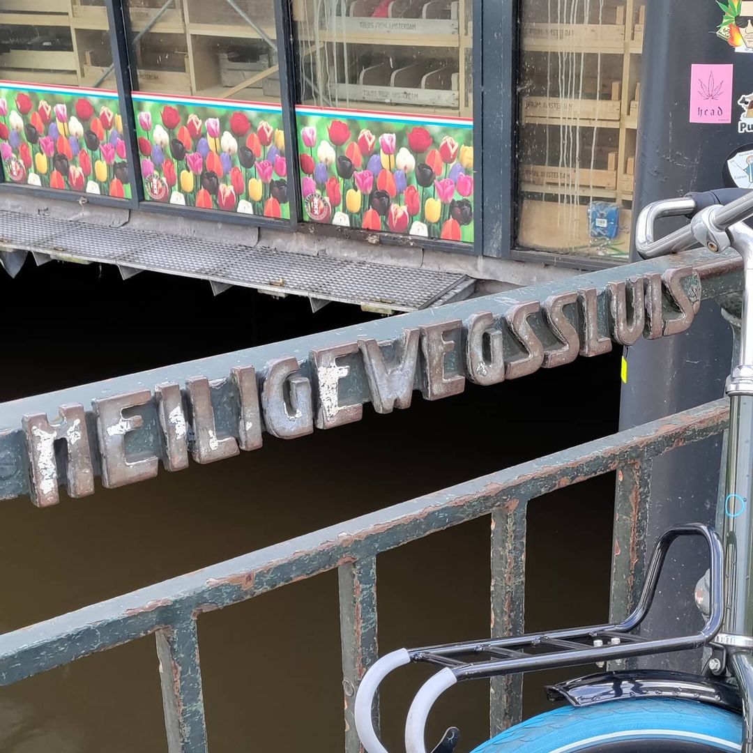
It’s also where the flower market starts so if you’ve visited Amsterdam you may have already been across both this bridge and bridge no.1 (Muntsluis)
The world famous Bloemenmarkt starts here on the southern quay of the Singel. The bridge is more than 45 metres wide including the Koningsplein, while the gap left for boats to pass beneath is barely 7 metres.


A Holy Way, a Vanished Gate, and a Bridge That Hides in Plain Sight
A Name Rooted in Miracle and Pilgrimage
Of all the numbers that could have been assigned to Amsterdam’s 1,700-plus bridges, Bridge 2 feels quietly significant. It carries the name Heiligewegsluis, “the lock on the Holy Way,” and there is nothing accidental about it. The Heiligeweg, meaning “Holy Way” or “Holy Street,” was not simply a road: it was the principal overland pilgrimage route into Amsterdam following the Miracle of Amsterdam on 16 March 1345. The miracle unfolded at the bedside of a dying man in a house near the Kalverstraat. Upon receiving the last rites, the man vomited the Host, which was placed in the fire according to liturgical custom. The following morning, it was found intact in the ashes, untouched by flame. Within months, the site was recognized as sacred by the municipality and the Bishop of Utrecht. A pilgrimage chapel, the Kapel ter Heilige Stede (Chapel of the Holy Site), was built over the very spot, and a new street was laid out to guide the growing flood of pilgrims from the city gate to the chapel: that street was the Heiligeweg. The route itself stretched far beyond the current short shopping street. Pilgrims arriving from Haarlem, Leiden, and as far as the German lands would travel via Sloten and Amstelveen, following what is now the Sloterweg and Rijnsburgstraat, then along the present-day Overtoom (originally the Heiligewegse Vaart, a canal), and finally along the Leidsestraat corridor into the city. The bridge at what is now the Singel stood right at the entrance: the point where pilgrims crossed the moat and passed through the gate into Amsterdam proper. For more than a century and a half, this crossing was among the most heavily trodden in all of Holland. The connection between Heiligeweg and imperial prestige is striking. The Holy Roman Emperor Maximilian of Austria, who joined the Miracle Procession while gravely ill in 1489 and reportedly recovered his health, was so moved that he granted Amsterdam the right to display the Imperial Crown of the Holy Roman Empire above the city crest. That same crown still tops the Westertoren today, a reminder that a pilgrimage route crossing this very bridge shaped Amsterdam’s identity for centuries.The Vanished Gate: The Heiligewegspoort
Where the bridge now stands, a city gate once rose: the Heiligewegspoort, the Holy Way Gate. This was not a simple wooden barrier but a proper architectural landmark. The gate had first been built in timber; in 1637 it was rebuilt in stone to a design by Jacob van Campen (1595-1657). Van Campen, working in an elegant classicizing style with Ionic pilasters, a symmetrical pediment, and decorative urns on the roofline, was making his first significant statement in Amsterdam, a city he would soon reshape with his masterpiece, the new Town Hall (now the Royal Palace) on the Dam. The gate served its function for barely a generation. Amsterdam’s voracious fourth urban expansion, completed around 1664, pushed the city boundary far to the west, to a new and grander gate: the Leidsepoort. The Heiligewegspoort, now marooned in the middle of the city, was demolished in 1664, a striking example of civic progress swallowing its own recent monuments. The speed of the demolition made it an object of mourning and fascination among Amsterdam’s artists. The gate was painted repeatedly, by Jan van Kessel and, more than once, by Jan Abrahamsz. van Beerstraten, who showed it in winter with skaters on the moat outside it. Painters recorded what the city was erasing, and so the gate’s image survived long after its stones were gone. The site where the gate stood became the open plaza we know today as Koningsplein, which itself came into being in 1663 when the Heiligewegburgwal, the small canal running alongside the Heiligeweg, was drained and filled in.From Sluice to Fixed Bridge: The Structural Story
The history of the bridge’s physical form mirrors Amsterdam’s transformation from a medieval trading city to a modern metropolis. In its earliest incarnation, the crossing here was not merely a bridge but a sluice (sluis): a lock with a keeper’s house, regulating the flow of water between Amsterdam’s inner canals and the outer Amstel. This function explains the “sluis” in the bridge’s name, a title it has retained even as the hydraulic role long since disappeared. The original structure included a wooden drawbridge (ophaalbrug) to allow small vessels to pass. This disappeared in 1792, when a fixed bridge was installed in its place, marking the end of any pretense that the crossing still served as a water lock. The 19th and early 20th centuries brought a succession of renovations as the demands of urban traffic intensified:- 1875/1876: The bridge received significant reinforcement, likely in response to heavier commercial use.
- 1882: A further structural modification, as Amsterdam’s street network expanded and standardized.
- 1909: A more substantial redesign, lowering the bridge deck to accommodate the horse-drawn trams (paardentrams) that had begun using this route. A lower profile was essential: the trams required a gentler gradient.
- 1927: The most transformative intervention. The bridge was widened substantially, integrating it into the broadened street and paved plaza area of Koningsplein. The result is the curious proportion still recorded today: measured including the Koningsplein pavement the bridge is over 45 metres wide, while the navigable opening left for boats beneath it is not quite 7 metres.
Bridge 2 in the Modern City: Hidden in Plain Sight
Here lies one of the Heiligewegsluis’s most charming qualities for the bridge-curious visitor: it is genuinely easy to miss. Standing on the broad, paved expanse of Koningsplein, surrounded by tram stops, flower stalls, and the flow of shoppers between Leidsestraat and the Kalverstraat, nothing obviously announces that you are standing on a bridge. The pavement underfoot is continuous; the canal below is out of sight unless you step to the railing. The bridge spans the Singel, Amsterdam’s innermost ring canal, and it does so quietly, beneath the feet of thousands of daily passersby who likely never notice. The tram infrastructure overhead is an excellent clue. Tram line 2, which has run through this intersection since 1903, and tram line 12, operating here since 2018, both cross the Singel at this precise point. If you watch where the tram tracks converge toward the water, you are watching a century-old transport artery threading itself across a medieval river crossing. The early 1970s conversion of the surrounding streets into a pedestrian zone stripped the bridge of much of its traffic function, reducing it to the role of pedestrian promenade and tram corridor. By 2017, the Koningsplein had settled so fully over the bridge deck that the structure beneath had become essentially invisible to all but the most attentive observers. On the Singel’s southern bank, beginning right at the bridge’s eastern end, lies the Bloemenmarkt, the world’s only floating flower market, established in 1862. The market occupies permanent pontoons moored along the Singel between Koningsplein and Muntplein, and the Heiligewegsluis effectively serves as its western anchor. Walking east from the bridge along the quay, visitors pass the famous stalls of tulip bulbs, seeds, and cut flowers that made this stretch of canal one of Amsterdam’s most photographed vistas.The Nameplate Mystery: One Bridge, Two Spellings
Look carefully at the nameplates attached to the bridge’s railings, and you may find something that has puzzled Amsterdam’s bridge enthusiasts for years. Two different nameplates appear, bearing two different spellings: “Heiligewegsluis” (with a single s between weg and sluis) and “Heiligewegssluis” (with a double ss). Both were present as recently as 2020, as documented in separate photographs archived by Wikimedia Commons, one file for each spelling. The discrepancy arises from the mechanics of Dutch compound word formation. When combining Heiligeweg (Holy Way) with sluis (lock), standard Dutch orthography uses a single s to join the components, giving Heiligewegsluis. This is the form used by Dutch Wikipedia, by Amsterdam’s official bridge name registry, and by most scholarly references. The double-ss version (Heiligewegssluis) follows an alternative compounding logic, treating the s at the end of wegs (the genitive form of weg) and the initial s of sluis as two separate letters that simply happen to sit together. In spoken Dutch, the difference is inaudible: both are pronounced identically. In written Dutch, only one can be correct, and the official answer is the single s form. The practical effect is that the bridge has carried contradictory identifications on its own railings, a small bureaucratic puzzle, and one the Dutch entry on the bridge notes without explaining. Whether this will be corrected in a future maintenance cycle, or whether the double-ss plate will persist as a charming anomaly, is a question perhaps best put to the Dienst Openbare Ruimte (the city’s public space authority).A Bridge Worth Stopping For
The Heiligewegsluis does not dazzle with grand ironwork or romantic curves in the way that some of its more celebrated neighbours on the Herengracht or Prinsengracht do. Its appeal is quieter and perhaps more durable: it is a place where medieval pilgrimage, the Golden Age city wall, Napoleonic-era engineering, Amsterdam School design sensibility, and 21st-century urban life have all left their marks, layered one upon the other. The next time you step off tram 2 or 12 at Koningsplein, take a moment before heading to the Bloemenmarkt or the Kalverstraat shops. Walk to the railing. Look down at the Singel. You are standing on a bridge that pilgrims once crossed on their way to a miracle.Sources
- Heiligeweg, Wikipedia (English)
- Stille Omgang (Silent Procession), Wikipedia
- Heiligewegsluis, Dutch Wikipedia
- Koningsplein (Amsterdam), Dutch Wikipedia
- Piet Kramer, Bridges of Amsterdam
- Piet Kramer, Wikipedia
- The Heiligewegspoort in Winter (National Trust Collections)
- Alamy: Third Heiligewegspoort engraving description
- De Andere Kaart Amsterdam: De Heiligeweg
- Miracle of Amsterdam, Amsterdam.info
- Bloemenmarkt, Amsterdam.net
- Wikimedia Commons: Category Brug 2, Heiligewegsluis
- Rasphuis Gate at Heiligeweg, MforAmsterdam

Read more


Heiligewegsluis – Wikipedia
De oostelijke kant van de brug in 2005, gezien vanuit de Heiligeweg
nl.wikipedia.org
Singel hoek Leidsestraat
Deze vaste brug is genoemd naar de Heiligeweg, waaraan zij ligt. Na het Mirakel van Amsterdam in 1345 werd tussen Rokin en Kalverstraat de kapel ‘Ter Heilige Stede’ gesticht en werd Amsterdam een populair bedevaartsoord. Ten behoeve van de bedevaartgangers werd de Heiligeweg aangelegd, die liep van…
www.bruggenvanamsterdam.nl
De Heiligewegsluis – Bridge 2 | History and information
There has been a bridge here for centuries, but it started with a lock with a lockkeeper’s house. At the beginning of the 17th century the lock had to be separated from the Amsterdam inland waters and the waters of the Amstel before the separation . Later, only the bridge remained. It once lay together on the city boundary of Amsterdam, right next to the Heiligewegspoort , which was demolished in 1663/1664 because the city boundary had shifted to the Leidsepoort due to the urban expansion. Architecht: unknown Koningsplein and the streets around it held a number of Jewish-owned shops. Under the German occupation Jewish businesses in the Netherlands were first compelled to register, then placed under non-Jewish administrators and sold off or liquidated, a process known as Aryanisation, while their owners were deported and in most cases murdered. The individual shops here are chronicled in Dutch at joodsamsterdam.nl.Koningsplein – joodsamsterdam
Het Koningsplein ontstond toen in 1663 de Heiligewegburgwal, het water langs de Heiligeweg, werd drooggelegd. In de 17e eeuw noemde men het Singel Koningsgracht als eerbewijs aan Koning Hendrik IV van Frankrijk; destijds een belangrijk bondgenoot van de Republiek. Toen deze naam niet veel later weer…
www.joodsamsterdam.nl
De Heiligewegsluis – Bridge 2 | Map and location
De Heiligewegsluis once lay on the city boundary of Amsterdam, right next to the Heiligewegspoort, which was demolished in 1663/1664 because the city boundary had shifted to the Leidsepoort due to the urban expansion. Amsterdam’s world famous flower market the “Bloemenmarkt” starts here on the southern quay of the Singel. https://w3w.co/pumps.jobs.material https://w3w.co/aanvoer.kastdeur.vlugger ///pumps.jobs.material ///aanvoer.kastdeur.vlugger 52.367225, 4.889764 This what3words address refers to a 3 metre square location. Tap the link or enter the 3 words into the free what3words app to find it.