An Arch Bridge on the Southern Quay of the Keizersgracht, Spanning the Reguliersgracht
There is a particular satisfaction in writing about Bridge 40 after Bridges 38 and 39. Together the three bridges form one of the most complete architectural compositions in the Amsterdam canal belt, and Bridge 40 is the element that closes the composition. Where Bridge 38 occupies the southern quay of the Reguliersgracht, and Bridge 39 occupies the northern quay of the Keizersgracht, Bridge 40 sits on the southern quay of the Keizersgracht, completing the bracket that wraps the four corners of the junction. And if the Anno stone divided across Bridges 38 and 39 carried “Anno” on one side and “1729” between Bridges 39 and 40 on the other, then Bridge 40 is the arch that literally holds the date: the “1729” stone sat between Bridge 39 and Bridge 40, making Bridge 40 the final stone of the inscription. The junction’s founding document was not written on a single bridge but distributed across three, and Bridge 40 carries its closing number.
Bridge 40 Unnamed. Brug veertig
Brug 40 like its predecessors #brug38 and #brug39 is unnamed.
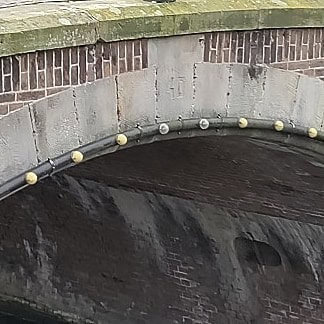
Like many of the central canal ring bridges, this is a connected bridge with the quay walls of the bridge seamlessly merging into those of #bridge38 and #bridge39 over the Keizersgracht and across the Reguliersgracht.


1. Etymology and Naming: No Name, No Former Informal Name, and the Purest of Numbers
Bridge 40 carries no official name and has never carried an informal one. Unlike Bridge 38, which bore the unofficial Oetgenssluis label until 2016, Bridge 40 appears in the bruggenvanamsterdam.nl register, the Wikipedia article on Bridge 40, and all other primary sources simply as Brug 40. It is the only bridge at the Keizersgracht/Reguliersgracht junction that has never attracted any naming attempt.
This absence is not arbitrary. Bridge 40 is located in the southern quay of the Keizersgracht, spanning the Reguliersgracht. Its position is the mirror of Bridge 39’s: where Bridge 39 sits on the northern quay, Bridge 40 sits on the southern quay, and both span the same waterway, the Reguliersgracht. Bridge 38, at right angles to both, spans the Keizersgracht. The three bridges form a right-angled triangle of masonry at the canal junction, each covering a different side of the crossing. To name one and not the others would have been architecturally arbitrary, and the informal naming of Bridge 38 as Oetgenssluis was itself eventually abolished for precisely the reason that a more appropriate bridge, Bridge 76, had already been formally named for Oetgens.
Bridge 40 has therefore always been a number. In a series that has produced named bridges honouring a flower seller, an archivist, a court painter, a medieval sausage maker, and a 17th-century surveyor, it is refreshing and entirely honest that one element of the canal belt’s most celebrated junction asks nothing more of the visitor than to count to forty.
2. Structural Evolution: Built in 1729, Rebuilt in 1908 to 1909, and Carrying Half of a Date Stone
The history of Bridge 40 is most probably identical to that of Bridge 38 from its construction. Between Bridge 40 and Bridge 39, a stone had been set with “1729.” Between Bridge 39 and Bridge 38, on the other side of the Keizersgracht, a stone with “Anno.” Both stones were removed during the renovation in 1908 to 1909.
This distribution of the Anno stone is one of the most distinctive details in the entire series of thirty-nine bridges documented so far. The three bridges were not simply built at the same time. They were conceived as a single architectural inscription, and the date of that inscription was physically split between them: “Anno” on the northern side of the Keizersgracht, “1729” on the southern side, with Bridge 39 standing in between as the silent fulcrum. Any reading of the date required crossing the canal or knowing the bridge on the other side. The three bridges were, in the most literal possible sense, one text written across water.
As established in the posts for Bridges 38 and 39, the current structure is a 20th-century construction rather than a surviving 18th-century arch. This arch bridge, like several other bridges in the Reguliersgracht, is not the original but a 20th-century construction. The 1908 to 1909 renovation that removed the Anno stones also rebuilt the structural fabric of all three bridges during a ten-month dewatering exercise that emptied the canal entirely, reinforced the foundations, and returned the bridges to traffic in the spring of 1909.
The key measurements are confirmed in the Dutch Wikipedia article: the bridge has a navigation opening 6.80 metres wide and 2.38 metres high. These dimensions match those of Bridge 39 exactly, confirming that Bridges 39 and 40, the two quay bridges of the Keizersgracht at this junction, were built to identical specifications as a symmetric pair.
There have been multiple plans to fill in the Reguliersgracht, but these have never been executed. As documented in the Bridge 38 post, the campaign to save the Reguliersgracht from infilling in the 1900s was one of the most consequential heritage battles in Amsterdam’s history. Had the plans succeeded, the canal, the seven-bridge alignment, the fifteen-bridge panorama, and Bridges 38, 39, and 40 would all have been demolished. The canal under Bridge 40 would now be a tram route or a road. The canal belt might well have lost its UNESCO World Heritage status before the designation existed to protect it.
3. Architectural Lineage: A 20th-Century Arch in 18th-Century Form, and the Third Corner of a Seamless Composition
No individual architect is confirmed for Bridge 40 in any source consulted for this post. It belongs to the Dienst der Publieke Werken’s tradition of canal belt bridge construction without any named designer.
The quay walls of Bridge 38 merge seamlessly with those of Bridge 39 and Bridge 40, which lie in the quays of the Keizersgracht and span the Reguliersgracht. This seamlessness, the defining architectural quality of the trio, applies with equal force to Bridge 40. From the southern approach, looking north across the Keizersgracht toward Bridges 39 and 38, what the eye sees is not three bridges but one continuous masonry envelope wrapped around a canal crossing. The joints between bridge numbers are invisible in the stonework.
The bridge itself is not a monument, but is surrounded by rijksmonumenten. This is the only distinction between Bridge 40 and its neighbour Bridge 38 in terms of heritage status: Bridge 38 has been a gemeentelijk monument since 1995, while Bridge 40 is not listed. Bridge 39 also carries monument status. Bridge 40, the southern face of the trio, is the one element of the composition that carries no formal heritage designation of its own, despite being structurally and visually inseparable from the two that do.
This distinction may reflect the logic of designating the composition by its most visible elements rather than exhaustively listing all of its components. Bridge 38, as the bridge most directly associated with the famous canal panorama and the one that carried the former informal name, received the listing. Bridge 39, as the central quay bridge, received it too. Bridge 40, completing the bracket from the south, was documented and surrounded by protected structures without being formally listed itself.
4. Urban and Social Context: The Southern View, the Museum Willet-Holthuysen, and the Approach From the Amstelveld
Bridge 40 is the bridge from which the seven-bridge Reguliersgracht alignment is approached from its southernmost urban context: the area around the Prinsengracht, the Amstelveld, and the Museum Willet-Holthuysen. Someone walking north along the Keizersgracht from the direction of the Utrechtsestraat or the Museum Van Loon reaches Bridge 40 before they reach Bridge 39, which means Bridge 40 is the first element of the junction encountered from that direction.
The Museum Willet-Holthuysen at Herengracht 605 is the dominant cultural institution in the immediate neighbourhood. The house was built for Jacob Hop, mayor of Amsterdam, around 1685. In 1739 the outside was redesigned to look as it does today, in the then-fashionable Louis XIV style. In 1895, its owner Louisa Holthuysen bequeathed the building and its contents to the city of Amsterdam on condition that it became a museum bearing their and her husband’s names. In 1895, this imposing 17th-century canal house, including its furnishings and art collection, was bequeathed to the city of Amsterdam by Mrs. Willet-Holthuysen. The house has a beautiful city garden laid out in 18th-century French style and decorated with historic trees and plant species. The museum is a five-minute walk from Bridge 40 along the Herengracht, and it occupies almost the same historical moment as the bridge’s original construction: the house was redesigned in 1739, ten years after the Anno stone of 1729 was set into the bridge quay wall.
The Reguliersgracht beneath Bridge 40 hosts the annual Seven Bridges Jazz Festival each September, and from Bridge 40’s deck the full southern run of the Reguliersgracht alignment extends into the distance toward the Prinsengracht. The Reguliersgracht was established in 1658 and is located in the Grachtengordel, in the Centrum borough. The alignment it produces, six arches diminishing southward from Bridge 40’s position, is one of the defining visual experiences of this part of the canal belt, and it is available from Bridge 40 as a direct southward perspective, the mirror of the northward alignment available from Bridge 39.
5. Technical Specifications
Based on confirmed sources, the following can be stated:
- Bridge type: Fixed arch bridge (vaste welfbrug); 20th-century construction in 18th-century form
- Location: Southern quay of the Keizersgracht, spanning the Reguliersgracht, Amsterdam-Centrum
- Canals: Reguliersgracht (dug 1658, named after the Reguliersklooster, approximately 300 metres long, connects Herengracht to Lijnbaansgracht); Keizersgracht (dug from 1615, widest canal in Amsterdam’s inner city at 28.31 metres)
- Navigation opening: 6.80 metres wide, 2.38 metres high (identical to Bridge 39)
- Anno stone: “1729” sat between Bridges 40 and 39; “Anno” sat between Bridges 39 and 38, on the other side of the Keizersgracht; both stones removed during the 1908 to 1909 renovation
- Original construction: 1729, shared with Bridges 38 and 39 as a single architectural inscription distributed across three bridges
- Current structure: 20th-century construction (1908 to 1909 renovation); not a genuinely 18th-century arch in its surviving fabric
- Structural relationship: Quay walls merge seamlessly with Bridge 39 (northern quay, Keizersgracht over Reguliersgracht) and Bridge 38 (southern quay, Reguliersgracht over Keizersgracht); together they form a single architectural composition at the junction
- Designer: Dienst der Publieke Werken; no individual architect confirmed
- Amsterdam School attribution: None
- Monument status: Not a monument (geen monument); surrounded by rijksmonumenten; contrast with Bridge 38 (gemeentelijk monument since 1995) and Bridge 39 (gemeentelijk monument since 1995)
- No name: Bridge 40 has never carried an official or unofficial name, making it the only element of the Keizersgracht/Reguliersgracht junction trio that has never been named
- Wikidata: Q19858044
- Position in the Reguliersgracht alignment: Fourth bridge from the northern end of the Reguliersgracht (after Bridge 31/Tante Saarbrug at Herengracht, Bridge 38 and Bridge 39/40 at Keizersgracht, then continuing south to Bridges 71, 72, 73, 74 toward the Prinsengracht)
Sources Consulted
- Bruggenvanamsterdam.nl, bridge register entry for Brug 40: www.bruggenvanamsterdam.nl/keizersgracht_hoek_reguliersgrac2.htm
- Wikipedia (nl), “Brug 40”: nl.wikipedia.org/wiki/Brug_40
- Wikipedia (nl), “Brug 38”: nl.wikipedia.org/wiki/Brug_38
- Wikipedia (nl), “Brug 39”: nl.wikipedia.org/wiki/Brug_39
- Amsterdam op de kaart, “Brug 38, Reguliersgracht”: amsterdamopdekaart.nl/1850-1940/Reguliersgracht/Brug_38
- Wikipedia (en), “Keizersgracht”: en.wikipedia.org/wiki/Keizersgracht
- Wikipedia (en), “Reguliersgracht”: en.wikipedia.org/wiki/Reguliersgracht
- Wikipedia (en), “Museum Willet-Holthuysen”: en.wikipedia.org/wiki/Museum_Willet-Holthuysen
- Lonely Planet, “Museum Willet-Holthuysen”: lonelyplanet.com/the-netherlands/amsterdam/southern-canal-ring/attractions/museum-willet-holthuysen
- I Amsterdam, “Huis Willet-Holthuysen”: iamsterdam.com/en/whats-on/calendar/museums-and-galleries/museums/huis-willet-holthuysen
- Amsterdam for Visitors, “Reguliersgracht: Seven Bridges Amsterdam”: amsterdamforvisitors.com/reguliersgracht/
- Wikidata, “Brug 40” (Q19858044): www.wikidata.org/wiki/Q19858044
- Wikimedia Commons, Category: Brug 40 (Amsterdam): commons.wikimedia.org/wiki/Category:Brug_40_(Amsterdam)
- Frank V. Smit, “Bruggen in Amsterdam,” 2008, Uitgeverij Matrijs (cited in Wikipedia nl, “Brug 40”)
Public Domain Images

1. Wikimedia Commons: Category Brug 40 (Amsterdam) contemporary photographs The Wikimedia Commons category for Bridge 40 holds contemporary photographs of the bridge in its current form, including images showing the southern approach from the Keizersgracht and the Reguliersgracht alignment visible from the bridge deck. Available under free licences. URL: https://commons.wikimedia.org/wiki/Category:Brug_40_(Amsterdam) Attribution: “Wikimedia Commons, Category: Brug 40 (Amsterdam). Available under the licences specified on individual file description pages.”

2. “Reguliersgracht 39-37-35 enz rechts, vrnl Gezien in noordelijke richting vanaf kruising Keizersgracht,” RCE, Wikimedia Commons This photograph from the Rijksdienst voor het Cultureel Erfgoed (RCE) collection, referenced in the Bridge 39 post as showing the Reguliersgracht’s northern alignment from the Keizersgracht junction, is equally relevant to Bridge 40, as it shows the same junction from the southern quay position occupied by Bridge 40. Available under a public domain or open licence through the RCE. URL: https://commons.wikimedia.org/wiki/File:Reguliersgracht_39-37-35_enz_rechts,_vrnl_Gezien_in_noordelijke_richting_vanaf_kruising_Keizersgracht_Rechts_hoek_Ke_OSIM00001004495.jpg Attribution: “Rijksdienst voor het Cultureel Erfgoed (RCE). Public domain.”

3. Museum Willet-Holthuysen, facade photograph, Stadsarchief Amsterdam The Museum Willet-Holthuysen at Herengracht 605, built for Amsterdam mayor Jacob Hop around 1685 and redesigned in 1739 in the Louis XIV style, is the dominant cultural institution adjacent to Bridge 40. Historical photographs of the museum’s facade and the adjacent Herengracht are held in the Stadsarchief Amsterdam Beeldbank. As a 19th-century double mansion, the building appears in numerous public domain photographs from the Stadsarchief collection. URL: https://archief.amsterdam/beeldbank (search: “Willet Holthuysen Herengracht 605”) Attribution: “Collectie Stadsarchief Amsterdam. Available for non-commercial use with attribution.”
Location and map of Bridge 40 (Unnamed)
Bridge 40 is a bridge in the southern quay of the Keizersgracht over the Reguliersgracht in the Amsterdam canal belt. The quay walls of the bridge merge seamlessly into those of #brug38 and #brug39 which lie over the Keizersgracht and also across the Reguliersgracht.


Information and history of Bridge 40 (Unnamed)
Just like some other bridges in the Reguliersgracht, this arch bridge is not original but a 20th-century construction. The history of the bridge is presumably the same as that of #bridge38 and #39 from its construction and the fact they are merged. Between bridges #brug38 and #brug39 there was a brick with “Anno”, between bridges 39 and bridge 40, on the other side of the Keizersgracht a stone with “1729”. Both stones were removed during the renovation in around 1908/1909.

Pics from Amsterdam archives
Brug 40 over de Reguliersgracht gezien naar Keizersgracht 659-661, rechts aansluitend de zijgevel van Reguliersgracht 38 Jacob Olie Jbz. 1893