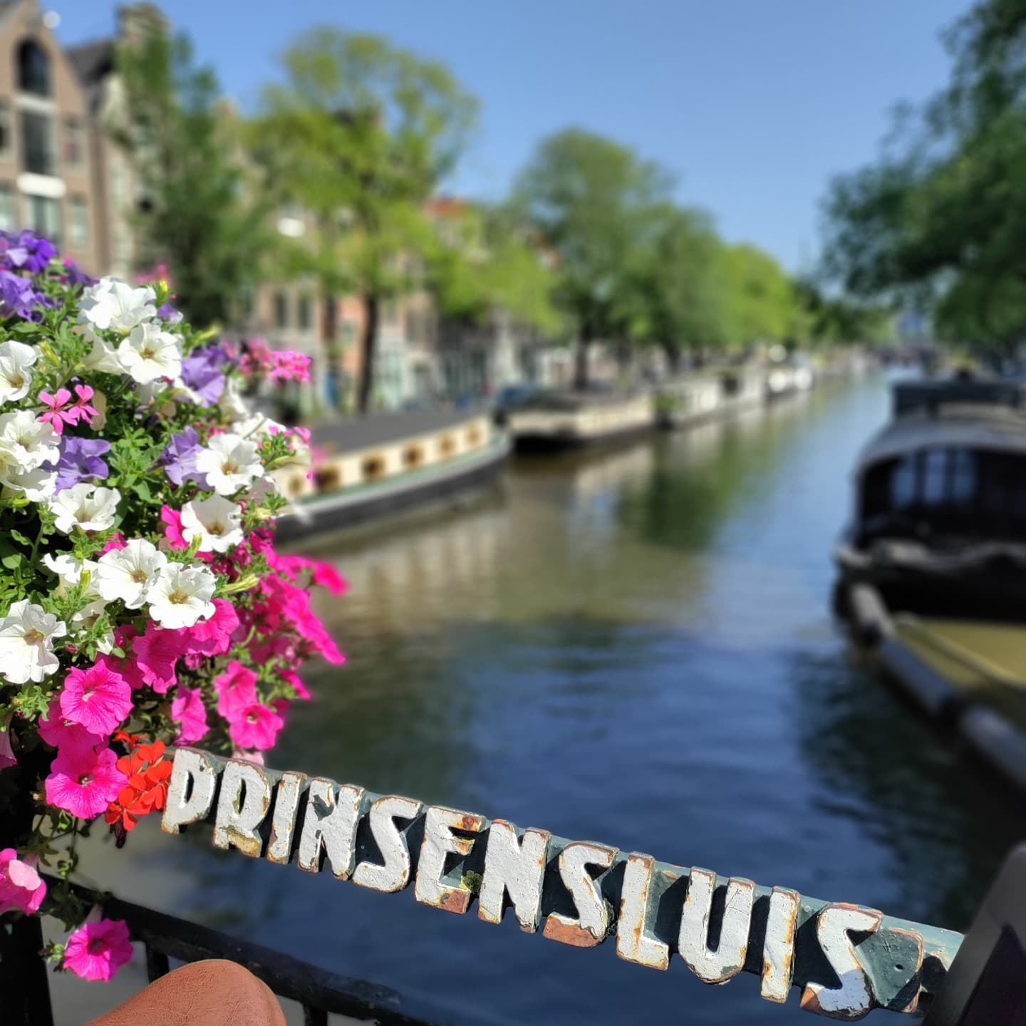
The Prinsensluis, Bridge 60, carries the Prinsenstraat over the Prinsengracht in the Jordaan. It’s a bridge whose real character comes from two things that have nothing to do with its 1767 datestone: a mismatched street grid that’s sent vehicles careening into the corner pub for well over a century and a supporting role in one of Amsterdam’s deadliest nineteenth-century riots.
Just like the canal and the cross street located here the name of #brug60 the Prinsensluis comes from the Prince of Orange. Regarding the naming of Prinsensluis, it is named after Prince Maurits of Nassau, who was a prominent figure in the Dutch Republic during the 17th century. Maurits was the son of William the Silent, who played a key role in the Dutch struggle for independence from Spain. Maurits himself was a military commander and statesman who played a significant role in the Dutch Republic’s rise to power during the 17th century.
Since the layout of the Jordaan is different from that of the histric canal belt, the Anjeliersstraat, located slightly more to the north, does not completely connect to the bridge and a so-called pie slice stands in the way. Consequently the café located on this corner has had number of vehicle hit it due to cars overshooting.


1. Etymology and Naming: A Bridge, a Canal and a Street, All Named for the Same Prince
The Prinsensluis takes its name from the Prince of Orange, the same source as both the Prinsengracht it crosses and the Prinsenstraat it carries. Dutch Wikipedia attributes the name generally to “the Prince of Orange” without identifying a specific individual. The bridge is often said locally to be named for Maurits of Nassau in particular, which fits the timing of the Jordaan and the canal belt, but no source consulted here confirms it.
2. Structural Evolution: A Seventeenth-Century Crossing, Nineteenth-Century Politics and a Deck Younger Than It Looks
There has been a bridge at this exact spot for centuries. Balthasar Florisz. van Berckenrode’s map of 1625 already shows a five-arched predecessor bridge here, at that point the streets on either side were still called Prince Straet and Angeliers Straet and the bridge crossed what was then labelled Prince Graft. Joan Blaeu’s map of 1649 shows a bridge here too.
The piers of the current bridge date from 1767, confirmed by a datestone in the right-hand pier (looking north) and the word “Anno” carved into the left-hand pier, together reading “Anno 1767.” But the deck itself is younger than the piers suggest: the iron beams visible in recent years point to a later rebuild and the documentary record explains why. On 8 July 1878, the city issued a tender to lower and widen the bridge, which at the time had three passages, the largest 6.82 metres wide and 2.10 metres high.
That 1878 project came with a genuine political fight attached. Amsterdam’s Chamber of Commerce opposed lowering the bridge, since goods still needed to reach the local market by boat and proposed a movable bridge as an alternative. The city council (Burgemeester en Wethouders) dismissed the objection, pointing to a prior 1873 decision to lower other bridges and noting the iron for the project had already been ordered under an earlier tender. To back their position, the council ran a week-long traffic count: 14,028 pedestrians and 457 vehicles were, on average, inconvenienced daily by the bridge’s steep approach, while officials argued most boats could pass under the new, lower bridge regardless. The council voted 20 to 12 in favour of lowering and the widening that followed used what Wikipedia describes as an almost standard procedure for bridge-widening projects in late-nineteenth-century Amsterdam.
The bridge deck was opened up again in 1938 for repair and the road surface has needed regular replacement since.
3. Architectural Lineage: A Plate Bridge, Not an Arch
The Prinsensluis is classified as a plaatbrug, a plate or flat bridge, structurally distinct from the arch bridges (welfbruggen) common elsewhere on Amsterdam’s canals. No individual architect or engineer is identified in the sources consulted, either for the 1767 piers or the 1878 lowering and widening; the latter is described simply as following the routine civil-engineering approach the city used repeatedly for similar bridge projects in that period.
4. Urban and Social Context: A Grid Mismatch With Consequences and a Deadly Riot
The Prinsensluis sits at a genuine seam in Amsterdam’s urban fabric. The Jordaan was laid out on a different street grid than the historic canal belt and as a result the Anjeliersstraat, slightly north of the bridge, doesn’t line up cleanly with it; a wedge-shaped “pie slice” of a corner plot sits in the gap instead.
That mismatch has had real, repeated consequences. The bridge’s approach is steep enough that vehicles have overshot it and crashed into the corner café, Het Bruine Paard, a pub that has carried that name since the nineteenth century, on more than one occasion. In 1883, a horse and cart went off the bridge; some years later, an ice-cart with its horse slid off in the same way. The most serious incident came in January 1907, when a fire truck attempting to climb the bridge slid back down and rammed the facade of the corner building, which had only just been newly constructed. The vehicle had to be hauled out of the building by force and a woman who had been dragged into the building along with it died on the way to hospital. That same corner building carries a facade stone recording the laying of its first stone on 19 November 1906, meaning the building had barely gone up before a fire engine drove into it.
The bridge sits amid a cluster of well-patronised Jordaan pubs, fitting for a neighbourhood built around close-knit street life.
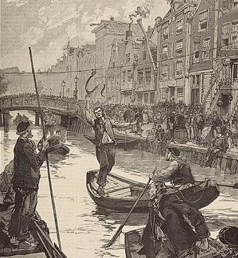
In 1886, the bridge played a role in one of the darker episodes in Amsterdam’s modern history: the Palingoproer (Eel Riot), a two-day popular uprising in the Jordaan on 25 and 26 July. It began when police tried to stop a banned game called palingtrekken (eel-pulling), in which players in boats tried to grab a live eel hung from a rope stretched across a canal, on the nearby Lindengracht. The intervention triggered a confrontation that escalated into a full uprising; protesters threw rocks at police and, on the second day, at the army called in as reinforcement. Troops fired back with live ammunition. By the time order was restored, 26 people had been killed.
Heights around the bridge and the surrounding canal are measured against NAP (Normaal Amsterdams Peil), the Amsterdam Ordnance Datum used as the Netherlands’ national sea-level reference; the canal water level at this point sits at NAP −40 cm.
Brug 60/Prinsensluis map and location
///beans.gently.scrum
#bridge60 is located in front of the Prinsenstraat and leads over the Prinsengracht. It therefore also connects its two quays. On the other side (out of town) there is no through road (other than the quay).
No prizes for guessing there has been a bridge here for centuries. Joan Blaeu drew a bridge here on his map from 1649, but also Balthasar Florisz. van Berckenrode had already drawn a bridge (with five arches) on his map from 1625. On that last map, both streets were still called Prince Straet and Angeliers Straet and the bridge crosses Prince Graft.


Prinsensluis/Bridge 60 information and history
The current #bridge60 (or at least the piers of the current bridge) dates from 1767, as evidenced by a date stone in the right pier when looking north and then on the left pillar you will find inscribed “Anno” so “Anno 1767”.
The bridge played a role in the Eel Riot in 1886 when protesters threw rocks at police and infantry who fired live ammunition; there were dead and wounded at the riot. The Palingoproer or the Eel riot was a popular uprising in the Jordaan in Amsterdam on July 25 and July 26, 1886. The riots started when the police tried to thwart playing the forbidden game of eel pulling on the Lindengracht.


Photos from the archive
1. Prinsensluis (brug 60) over de Prinsengracht bij de Prinsenstraat Collectie Bureau Monumentenzorg 1953 ca. t/m 1995 ca.
2. Han van Gool, Collectie Bureau Monumentenzorg 1976
3. In wintertooi. de Prinsensluis (brug 60) naar de Noordermarkt. Martin Alberts, Collectie Stadsarchief Amsterdam: 21 december 2007
4. Prinsensluis (brug 60) over het water van de Prinsengracht bij de Prinsenstraat 1953 ca. t/m 1995 ca
5. Prinsensluis (brug 60) Han van Gool, Collectie Bureau Monumentenzorg: 1976
6. Saturday bridge for Tweede Goudsbloemdwarsstraat (left) and Eerste Lindendwarsstraat (right). Horizon with Roman Catholic Church De Posthoorn. Photo probably taken as a result of the Eel riot. Onbekend, Anoniem
7. The Lindengracht before the damping, looking at the Saturday bridge – notorious for the Palingo riot Description The Lindengracht with the Saturday Bridge in front of the Eerste Lindendwarsstraat. The bridge was notorious for the eel riot. Collectie Atlas Dreesmann 1883 t/m 1895
5. Technical Specifications
Based on confirmed sources, the following can be stated:
- Bridge type: Plaatbrug (plate/flat bridge)
- Location: Prinsengracht at Prinsenstraat, Amsterdam-Centrum
- Coordinates: 52°22′41″N, 4°53′11″E
- Managed by: Stadsdeel Centrum
- Current piers date: 1767 (“Anno 1767” datestone split across both piers)
- Deck history: Lowered and widened following a tender issued 8 July 1878; iron deck materials suggest the current deck postdates the 1767 piers; deck opened for repair again in 1938
- Passages (as of the 1878 works): Three, the largest 6.82 m wide, 2.10 m clearance height
- First cartographic appearance: A five-arched predecessor bridge on Balthasar Florisz. van Berckenrode’s map of 1625 (when the site was known as Prince Graft); also shown on Joan Blaeu’s map of 1649
- Height reference: NAP (Normaal Amsterdams Peil); canal water level here is NAP −40 cm
- Notable history: Site of the 1886 Palingoproer (Eel Riot, 26 killed); repeated vehicle-overshoot incidents at the corner café, including a fatal fire-truck crash in January 1907
- Etymology: Named after the Prince of Orange, as are the adjoining Prinsengracht and Prinsenstraat
Sources Consulted
- Wikipedia (nl), “Prinsensluis”
- Wikipedia (en), “Palingoproer”
- Algemeen Handelsblad, 31 August 1878, “Aan den Gemeenteraad! Onderwerp 351” (cited in Wikipedia nl)
- Beeldbank Amsterdam / Stadsarchief Amsterdam, drawing of the 1878 lowering and widening (cited in Wikipedia nl)
- Wikimedia Commons, Category: Brug 60, Prinsensluis