A 20th-Century Arch on the Northern Quay of the Keizersgracht, Spanning the Reguliersgracht
There is a word in Dutch architectural heritage documentation that requires careful handling: “naadloos,” meaning seamless. The Dutch Wikipedia article on Bridge 38 uses it to describe the relationship between Bridges 38, 39, and 40 at the Keizersgracht/Reguliersgracht junction: their quay walls merge seamlessly into one another. That seamlessness is both a structural fact and a philosophical statement about how this corner of Amsterdam was built. The three bridges do not merely coexist at an intersection. They form a single architectural composition, a continuous masonry envelope wrapping around the point where Amsterdam’s widest canal and its most beautiful canal cross at right angles. Bridge 39 is the northern face of that composition: the crossing that carries the Keizersgracht’s northern quay over the Reguliersgracht, the arch that completes the junction when viewed from the north looking south.
Where Bridge 38 is the southern quay crossing, read most directly from the Thorbeckeplein side, Bridge 39 is the one seen by anyone approaching the junction from the direction of the Museum Van Loon or the Willet-Holthuysen. Together they make a whole that neither makes alone.
Bridge 39 like it’s predecessor Bridge 38 is unnamed.
The bridge itself is not very different from many of the other bridges with no fundamental outstanding features. Still, it is part of a group of seven bridges spanning the Reguliersgracht which are possibly some of the most photographed bridges in Amsterdam.


1. Etymology and Naming: No Name, and the Shared Anno Stone of 1729
Bridge 39 carries no official name and has never carried an informal one. In the bridge numbering system, it is simply Brug 39, and it appears in the bruggenvanamsterdam.nl register without any former name or naming history. This distinguishes it from its immediate neighbour Bridge 38, which carried the informal name Oetgenssluis until 2016. Bridge 39 was always simply a number.
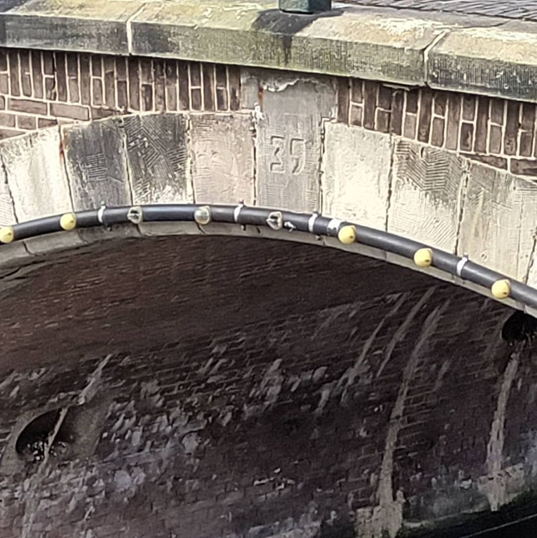
The reason for this absence is partly structural. The history of Bridge 39 is most probably identical to that of Bridge 38 from its construction. Between Bridge 38 and Bridge 39, a stone was built in with “Anno,” and between Bridge 39 and Bridge 40, on the other side of the Keizersgracht, a stone with “1729.” Both stones were removed during the renovation of 1908 to 1909.
This single documented fact tells a complete story. The Anno stone was not inscribed on one bridge. It was distributed across two bridges, with “Anno” on one side of the Keizersgracht and “1729” on the other, split by the width of the canal itself. The date belonged to the junction as a whole, not to any individual arch. To name one bridge after a figure from Amsterdam’s history while leaving the other unnamed would have been an arbitrary distinction within a structure that was, in its original conception, one thing.
The placement of the Anno stone across two bridges also reveals something about how 18th-century Amsterdam thought about infrastructure. A canal junction was a single civic object. The bridges that composed it were elements of that object rather than independent structures. The numbering system that arrived later, assigning separate digits to each crossing at a single intersection, imposed a distinctness that the original builders may not have recognised.
2. Structural Evolution: Built in 1729, Renovated in 1908 to 1909, and Not Genuinely 18th-Century in Fabric
Bridge 39 is an arch bridge (welfbrug). Like several other bridges in the Reguliersgracht, it is not the original structure but a 20th-century construction.
This is the critical structural fact about Bridge 39, and it applies equally to Bridge 38. The Anno stone of 1729 recorded the year of the original construction. The renovation of 1908 to 1909, which involved dewatering the canal and reinforcing the foundations over a period of ten months, replaced the structural fabric of both bridges while maintaining their outward appearance. What stands today is a 20th-century structure in an 18th-century form.
The distinction matters for heritage purposes, and it is why neither Bridge 38 nor Bridge 39 appears on the municipal monuments list as a genuinely 18th-century arch bridge. As established in the Bridge 38 post and confirmed in the bridges.cramberts.com entry for Bridge 73 in the Reguliersgracht series, only two of the seven bridges over the Reguliersgracht are genuinely 18th-century in origin and appear on the municipal monuments list: the bridge at the Herengracht, built in 1725 and reconstructed in 1784, and the Kerksluis, dating from 1780. The other five bridges are of later date.
Bridge 39’s current construction therefore dates from 1908 to 1909, even though its form echoes the 1729 original. The Anno stones that would have confirmed its date were removed in the same renovation that rebuilt it, a small but telling irony: the physical evidence of the bridge’s age was discarded precisely when the bridge that bore it was reconstructed.
The navigation opening of Bridge 39 is confirmed in the Dutch Wikipedia article: the bridge has a navigation opening 6.80 metres wide and 2.38 metres high. This matches the clearance specification of Bridge 38, confirming that both crossings at the junction were built to identical hydraulic standards.
3. Architectural Lineage: A 20th-Century Arch in 18th-Century Form, with Seamless Quay Walls
No individual architect is confirmed for Bridge 39 in any source consulted for this post. It is attributed to the Dienst der Publieke Werken without further specification. As with Bridge 38, it predates the Amsterdam School movement in its original form, and the 1908 to 1909 reconstruction was a repair and rebuilding exercise rather than a new architectural commission.
The quay walls of Bridge 38 merge seamlessly with those of Bridge 39 and Bridge 40, which lie in the quays of the Keizersgracht and span the Reguliersgracht. This seamlessness is the defining architectural quality of the three bridges taken together. From any angle on the water, the junction presents a continuous masonry composition: no gap, no interruption, no visual distinction between where one bridge number ends and another begins. The three arches, spanning different waterways in different directions, read as a single built object sitting in the water at a canal crossing.
The bridge itself has been a municipal monument since 1995, and is additionally surrounded by rijksmonumenten. The monument status applies to Bridge 39 as an element of the junction composition, not as an independently significant 18th-century structure.
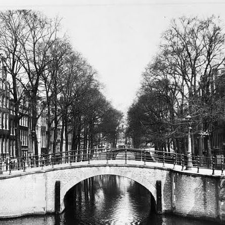
The closest artistic record of the view from this specific crossing, looking south along the Reguliersgracht from the Keizersgracht, is the painting by George Hendrik Breitner held in the Rijksmuseum. Breitner’s “Brug over de Reguliersgracht te Amsterdam, gezien vanaf de Keizersgracht,” 1913 to 1940, was documented by photographer Bernard Eilers and is held in the Rijksmuseum collection. The view Breitner chose, looking from the northern Keizersgracht quay directly south along the Reguliersgracht, is precisely the view available from the deck of Bridge 39. It is one of the most celebrated artistic records of any view from any bridge in this series.
4. Urban and Social Context: The Northern View, Het Parool, and the Seven Bridges Alignment
Bridge 39 occupies the northern side of the junction from which the seven-bridge alignment of the Reguliersgracht is most directly approached. Standing on Bridge 39 and looking south along the Reguliersgracht, the successive arches of the seven-bridge alignment present themselves in sequence: the crossing at the Keizersgracht immediately below, then Bridges 40, 71, 72, 73, 74, and the Prinsengracht arch beyond. This is the view captured by Breitner, reproduced in countless tourist photographs, and described by Lonely Planet as one of the defining experiences of Amsterdam.
The Reguliersgracht that runs beneath Bridge 39 is also a canal with a wartime history that is less widely known than its photographic celebrity. During the Second World War, the nerve centre of the illegal newspaper Het Parool was housed in a building on the Reguliersgracht, occupied by Simon Carmiggelt, Max Nord, Wim van Norden and their families. The Reguliersgracht at number 111 was therefore not only a location for canal views and jazz festivals but a place of clandestine resistance journalism, hidden behind the same gabled facades that now grace Instagram feeds.
The Museum Van Loon at Keizersgracht 672 is the most significant cultural institution within immediate walking distance of Bridge 39 along the canal’s northern bank. Museum Van Loon is a seventeenth-century canal house that has been kept in its original condition and is open to visitors. It is located between Bridges 37 and 39 on the Keizersgracht. The museum’s formal garden, its period-furnished rooms, and its family archive make it the most complete experience of Golden Age canal house life available in Amsterdam. Walking from Bridge 39 to Museum Van Loon takes approximately three minutes along the Keizersgracht’s northern quay.
The Reguliersgracht itself hosts the annual Seven Bridges Jazz Festival each September. The Reguliersgracht hosts the yearly Seven Bridges Amsterdam Jazz Festival, named after the seven bridges that span the canal, taking place every September at various venues along the canal with no charge for entry. Bridge 39’s position at the junction of the Keizersgracht and the Reguliersgracht makes it the festival’s geographical heart, the point where the seven-bridge alignment begins its run southward.
5. Technical Specifications
Based on confirmed sources, the following can be stated:
- Bridge type: Fixed arch bridge (vaste welfbrug); 20th-century construction in 18th-century form
- Location: Northern quay of the Keizersgracht, spanning the Reguliersgracht, Amsterdam-Centrum
- Canals: Reguliersgracht (dug 1658, named after the Reguliersklooster, approximately 300 metres long, connects Herengracht to Lijnbaansgracht); Keizersgracht (dug from 1615, widest canal in Amsterdam’s inner city at 28.31 metres)
- Navigation opening: 6.80 metres wide, 2.38 metres high
- Original construction: 1729, shared with Bridge 38; the Anno stone was inscribed across both bridges, with “Anno” between Bridges 38 and 39, and “1729” between Bridges 39 and 40
- Anno stones: Removed during the 1908 to 1909 renovation
- Current structure: 20th-century construction (1908 to 1909 renovation); not a genuinely 18th-century arch in its surviving fabric
- Structural relationship: Quay walls merge seamlessly with Bridge 38 (southern quay, Reguliersgracht over Keizersgracht) and Bridge 40 (northern quay of the Keizersgracht, also over the Reguliersgracht); together they form a single architectural composition at the junction
- Designer: Dienst der Publieke Werken; no individual architect confirmed
- Amsterdam School attribution: None
- Monument status: Gemeentelijk monument (municipal monument) since 1995; surrounded by rijksmonumenten
- No former informal name: Bridge 39 has never carried an official or unofficial name
- Wikidata: Q48802068
- Position in the Reguliersgracht alignment: Third bridge from the northern end of the Reguliersgracht; the second crossing of a main canal (after Bridge 38/Tante Saarbrug at Herengracht, before Bridge 40 and then Bridges 71, 72, 73, 74 at the Prinsengracht)
Sources Consulted
- Bruggenvanamsterdam.nl, bridge register entry for Brug 39: www.bruggenvanamsterdam.nl/keizersgracht_hoek_reguliersgrac1.htm
- Wikipedia (nl), “Brug 39”: nl.wikipedia.org/wiki/Brug_39
- Wikipedia (nl), “Brug 38”: nl.wikipedia.org/wiki/Brug_38
- Wikipedia (en), “Keizersgracht”: en.wikipedia.org/wiki/Keizersgracht
- Wikipedia (en), “Reguliersgracht”: en.wikipedia.org/wiki/Reguliersgracht
- Bridges.cramberts.com, “Bridge 73, Amsterdam” (Reguliersgracht series context): bridges.cramberts.com/amsterdam/bridge-73-amsterdam/
- Amsterdam for Visitors, “Reguliersgracht: Seven Bridges Amsterdam”: amsterdamforvisitors.com/reguliersgracht/
- Lonely Planet, “Reguliersgracht”: lonelyplanet.com/points-of-interest/reguliersgracht/1231961
- Rijksmuseum, “Brug over de Reguliersgracht te Amsterdam, gezien vanaf de Keizersgracht” (sketch, 19th century): www.rijksmuseum.nl/en/collection/object/Brug-over-de-Reguliersgracht-te-Amsterdam-gezien-vanaf-de-Keizersgracht
- Rijksmuseum, “Brug over de Reguliersgracht in Amsterdam,” Bernard Eilers photograph, 1913 to 1940: www.rijksmuseum.nl/en/collection/object/Brug-over-de-Reguliersgracht-in-Amsterdam
- Wikimedia Commons, Category: Brug 39 (Amsterdam): commons.wikimedia.org/wiki/Category:Brug_39_(Amsterdam)
- Wikimedia Commons, Category: Brug 38 (in Amsterdam), for shared junction imagery: commons.wikimedia.org/wiki/Category:Brug_38_(in_Amsterdam)
- Wikidata, “Brug 39” (Q48802068): www.wikidata.org/wiki/Q48802068
- Frank V. Smit, “Bruggen in Amsterdam,” 2008, Uitgeverij Matrijs (cited in Wikipedia nl, “Brug 39”)
Public Domain Images

1. George Hendrik Breitner, “Brug over de Reguliersgracht te Amsterdam, gezien vanaf de Keizersgracht,” c. 1890s, Rijksmuseum Breitner’s painting of the bridge over the Reguliersgracht as seen from the Keizersgracht is held at the Rijksmuseum and is accessible via Google Arts and Culture. Breitner (1857 to 1923) is fully in the public domain. This is the most celebrated artistic record of the precise view available from Bridge 39’s deck, looking south along the Reguliersgracht. URL: https://artsandculture.google.com/asset/brug-over-de-reguliersgracht-te-amsterdam-gezien-vanaf-de-keizersgracht-george-hendrik-breitner/GwHt8yv58mbg7Q Attribution: “George Hendrik Breitner, c. 1890s. Rijksmuseum Amsterdam. Public domain.”

2. “Reguliersgracht gezien van Keizersgracht naar Thorbeckeplein, 010005000424.jpg,” Stadsarchief Amsterdam / Wikimedia Commons This photograph is listed in the Wikimedia Commons category for Bridge 38 as “Reguliersgracht gezien van Keizersgracht naar Thorbeckeplein 010005000424.jpg,” a historical photograph from the Stadsarchief Amsterdam showing the view northward along the Reguliersgracht from the Keizersgracht junction, with Bridge 39 in the immediate foreground. Available via both Wikimedia Commons and the Stadsarchief Beeldbank. URL: https://commons.wikimedia.org/wiki/File:Reguliersgracht_gezien_van_Keizersgracht_naar_Thorbeckeplein_010005000424.jpg Attribution: “Collectie Stadsarchief Amsterdam, Afb 010005000424. Public domain.”

3. “Reguliersgracht 39-37-35 enz rechts, vrnl Gezien in noordelijke richting vanaf kruising Keizersgracht OSIM00001004495.jpg,” RCE / Wikimedia Commons This photograph, listed in the Wikimedia Commons category for Bridge 38 as “Reguliersgracht 39-37-35 enz rechts, vrnl Gezien in noordelijke richting vanaf kruising Keizersgracht Rechts hoek Ke OSIM00001004495.jpg,” is from the Rijksdienst voor het Cultureel Erfgoed (RCE) collection and shows the Reguliersgracht’s bridge numbers 39, 37, and 35 in northward sequence from the Keizersgracht crossing. Available under a public domain or open licence through the RCE. URL: https://commons.wikimedia.org/wiki/File:Reguliersgracht_39-37-35_enz_rechts,_vrnl_Gezien_in_noordelijke_richting_vanaf_kruising_Keizersgracht_Rechts_hoek_Ke_OSIM00001004495.jpg Attribution: “Rijksdienst voor het Cultureel Erfgoed (RCE). Public domain.”
Location and map of Bridge 39 (Unnamed) in Amsterdam
It is located in the northern quay of Keizersgracht and spans Reguliersgracht. The quay walls of the bridge merge seamlessly into those of #brug38 and #brug40 which lie over the Keizersgracht and across the Reguliersgracht.


Information and history of Bridge 39 (Unnamed)
Just like some other bridges in the Reguliersgracht, this arch bridge is not original but a 20th-century construction. The history of the bridge is presumably the same as that of #bridge38 from its construction and the fact they are merged. Between bridges #brug38 and #brug39 there was a brick with “Anno”, between bridges 39 and bridge 40, on the other side of the Keizersgracht a stone with “1729”. Both stones were removed during the renovation in around 1908/1909.
Pics from Amsterdam archives