An 18th-Century Stone Bridge Where the Reguliersgracht Meets the Keizersgracht, and the Memory of a Mayor Who Built and Profited From the Canals He Ordered Dug
Bridge 38 carries no official name and, since July 2016, carries no informal one either. It sits precisely at the point where the Reguliersgracht crosses the Keizersgracht, the junction from which Amsterdam’s famous seven-bridge alignment is viewed, and from which, looking in the other direction, fifteen bridges can be counted across the Keizersgracht. It is surrounded by rijksmonumenten. It was, around 1900, documented with an Anno stone reading 1729. It sank slightly in 1901, was nearly demolished as part of a plan to fill in the entire Reguliersgracht for a tram route, and was eventually rescued and rebuilt in a ten-month excavation that emptied the canal of water and was reported by De Telegraaf as ending the reign of terror it had imposed on Amsterdam’s horses. It is not the most celebrated bridge in this series, and it has never had a permanent name. But it occupies, quite literally, the most photographed canal intersection in the city.
Bridge 38 whilst unnamed is a municipal monument (since 1995).
This like many of the central canal ring bridges is a connected bridge with the quay walls of the bridge seamlessly merging into those of #bridge39 and #bridge40 in the quays of the Keizersgracht and across the Reguliersgracht.


1. Etymology and Naming: The Oetgenssluis, a Name Abolished, and the Man Who Earned and Lost It
Until 5 July 2016, this bridge was unofficially known as the Oetgenssluis, named after Frans Hendricksz. Oetgens (1559 to 1625), who was one of the founders of the canal belt. Since that date, the name has been abolished.
The bruggenvanamsterdam.nl register also records the reason the informal name was finally set aside: Oetgens’s name was already connected to the Frans Hendricksz. Oetgensbrug, Bridge 76, on the western quay of the Amstel over the Prinsengracht, which is the official namesake bridge. Having the same man’s name informally attached to a second bridge was considered redundant under the 2016 rationalisation. Bridge 76, carrying the official and formally adopted name, is his permanent monument in the city fabric. Bridge 38 reverts to its number alone.
The biography of Frans Hendricksz. Oetgens is one of the most complex of any figure associated with Amsterdam’s canal belt, combining genuine civic achievement with a financial scandal that made him the most controversial mayor of his generation. This fixed bridge at Bridge 76 is named after Frans Hendricksz. Oetgens (1559 to 1625). He was the city’s factory master (stadsfabriekmeester) who, together with Lucas Sinck, Hendrick Staets, and Hendrick de Keyser, prepared and partly executed the Uitleg (Expansion) of 1612, thereby laying the foundation of the Amsterdam canal belt.
Oetgens began his career as a master mason. In 1594 he became factory master (fabrieksmeester). He sat in the Amsterdam vroedschap, was schepen, and was involved from the beginning in the physical changes of the city. He served as mayor in the years 1598, 1599, 1604, 1607, 1611, 1612, 1615, 1617, 1619, 1622, and 1624. Eleven terms as mayor across nearly three decades placed Oetgens at the centre of every major urban decision in Amsterdam’s most transformative period.
His role in initiating the canal belt was decisive. In 1612, on his initiative, construction of the Prinsengracht and the Herengracht began. The first part of the Keizersgracht, between Brouwersgracht and approximately the current Leidsegracht, was dug in the summer of 1615 at the initiative of mayor Frans Hendricksz. Oetgens, city carpenter Hendrick Jacobsz. Staets, and city surveyor Lucas Jansz. Sinck.
But the achievement was shadowed by a serious conflict of interest. In 1611, Oetgens and his brother-in-law Bartholt Cromhout were accused by their fellow mayors Cornelis Hooft and Jacob Dircksz. de Graeff of improper practices in connection with the Third Expansion. The reason was that the two brothers-in-law had bought numerous plots of land outside the city cheaply, in order to sell them at a high profit when the city expanded over them. In 1615, Oetgens was reported to the High Court of Holland by Hooft. The man who ordered the Keizersgracht to be dug had already purchased land along its intended route. The bridge across the canal at its most famous intersection once bore his name, unofficially, and now bears nothing at all.
2. Structural Evolution: Stalpaert’s Plan of 1662, an Anno Stone of 1729, and a Crisis in 1901
There has been a bridge here for centuries. City architect Daniël Stalpaert drew the bridge in the design section of his map of 1662. Frederik de Wit drew it on his map of 1688. The sequence of documentary evidence here mirrors that of Bridges 35, 36, and 37, all in the same part of the southern canal belt.
The date of the current primary structure is confirmed by physical evidence that has since been lost. Around 1900, two stones were still visible on the bridge on either side, with “Anno” and “1729” milled into them. Jacob Olie and Herman Misset recorded this via a photograph in 1891 and a drawing in 1906. According to Misset, the bridge number was also chiselled into the central arch. The data were removed during the renovation in 1908. The loss of the Anno stones in 1908 is a small heritage tragedy: the most direct material evidence of the bridge’s 18th-century construction was discarded during the very renovation that saved the structure itself.
The modern history of the bridge begins with a threat that very nearly ended it. The modern history of the bridge begins in 1901, when it was found to have sunk slightly. The municipality did not want to repair it immediately, since it was investigating whether, for the purposes of building a tram, it should fill in the Reguliersgracht entirely, and a roundabout was planned here. In 1905 the bridge came to attention again.
In 1901, the city council proposed filling in the Reguliersgracht to create more space for traffic and a future electric tram. The protests that followed were fierce. The Reguliersgracht’s survival, and with it the seven-bridge alignment and the fifteen-bridge panorama from Bridge 38’s junction, was therefore not inevitable. It was the result of a public campaign that forced the municipality to abandon its tram-route plan and find an alternative.
Once the infilling plan was dropped, the repair of Bridge 38 could proceed. In March 1908 it became an extensive piece of work. In the middle of the works a building pit was created, in which all the canal water still had to be pumped out. All in all ten months had to be worked on the bridges, during which the foundations were also reinforced. During the works, temporary bridges were placed for various services. In the spring of 1909 the bridges could be reopened to traffic, with the announcement that they would no longer be “the terror of the Amsterdam horses,” as De Telegraaf reported on 16 January 1909. After that, presumably no major works have taken place at the bridge.
The newspaper quote deserves a moment of attention. The bridge had sunk enough, and apparently had an uneven surface or an awkward gradient, that horses pulling carts or carriages found it genuinely frightening to cross. The remediation of that hazard, through ten months of dewatered canal excavation and foundation reinforcement, was the single most significant structural intervention in the bridge’s history.
3. Architectural Lineage: 18th-Century Arch, Seamlessly Joined to Bridges 39 and 40, Pre-Amsterdam School
Bridge 38 belongs to the same 18th-century arch bridge tradition as Bridges 31, 35, and 36 in this series. No individual architect is confirmed for its design in any source consulted for this post, and it is attributed to the Dienst der Publieke Werken without further specification.
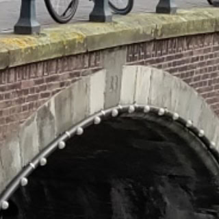
The bridge is a fixed bridge in Amsterdam-Centrum, situated in the southern quay of the Reguliersgracht spanning the Keizersgracht. The quay walls of the bridge merge seamlessly with those of Bridge 39 and Bridge 40, which lie in the quays of the Keizersgracht spanning the Reguliersgracht. The bridge itself has been a municipal monument since 1995, and is additionally surrounded by rijksmonumenten.
The detail about the seamless quay walls is architecturally significant. Bridges 38, 39, and 40 all meet at the same canal junction, and their abutments and quay walls form a continuous masonry composition rather than three separate structures. From the canal, this junction reads as a single unified element: a crossing of two waterways wrapped in brick and stone that flows without interruption from one bridge number to the next. That quality of seamless integration is one of the reasons this junction photographs as well as it does.
The bridge predates the Amsterdam School movement by approximately 180 years, and none of its features reflect Piet Kramer’s influence or Johan van der Mey’s aesthetic advisory work.
4. Urban and Social Context: The Fifteen-Bridge Panorama, the Seven-Bridge Alignment, and an Intersection That Was Nearly Filled In
Bridge 38 is the platform from which one of Amsterdam’s two most celebrated canal panoramas is available, and it is worth being precise about what can and cannot be seen from it, building on the geographical clarifications established in the Bridge 32 and Bridge 31 posts in this series.
When you look from where the Keizersgracht and Reguliersgracht come together east-to-west and north-to-south, you can see a total of 15 bridges at once. They’re not perfectly aligned, but make for a wonderful photo nonetheless. This view is available from the quayside at the junction rather than strictly from the bridge deck itself, but Bridge 38 is the structure that defines the intersection and gives the viewer their platform.
The Reguliersgracht, named by Lonely Planet as Amsterdam’s prettiest canal, was dug out in 1658. The seven bridges of the Reguliersgracht, of which Bridge 38 is the third from the northern end (counting from the Herengracht toward the Prinsengracht), form the alignment most closely associated with the canal in popular culture. Only two of the seven bridges are genuinely 18th-century in origin and appear on the municipal monuments list: the bridge at the Herengracht, built in 1725 and reconstructed in 1784, and the Kerksluis, dating from 1780. The other five bridges are of later date. Bridge 38, with its Anno stone of 1729, falls outside this confirmed list of the two genuinely 18th-century arch bridges, because its current visible form dates from the 1908 reconstruction rather than from its original 1729 construction. The 1729 date stones were removed in 1908, and it is the 1908 renovation that defines the physical structure visible today.
The neighbourhood around Bridge 38 is one of the densest concentrations of protected heritage in Amsterdam. The Museum Van Loon at Keizersgracht 672 is a short walk to the north. The Museum Willet-Holthuysen at Herengracht 605 is a few minutes to the west along the Herengracht. The KattenKabinet at Herengracht 497, the cat art museum housed in a Golden Bend canal mansion, is close by. The Reguliersgracht itself, for those who have not visited it before, is the canal described by multiple sources as Amsterdam’s most beautiful, a judgement supported by the extraordinary quality of the canal houses on both its banks and by the hypnotic visual effect of its seven arched bridges diminishing into the distance.
5. Technical Specifications
Based on confirmed sources, the following can be stated:
- Bridge type: Fixed arch bridge (vaste welfbrug)
- Location: Southern quay of the Reguliersgracht, spanning the Keizersgracht, Amsterdam-Centrum
- Canals: Reguliersgracht (dug 1658, named after the Reguliersklooster, approximately 300 metres long, connects Herengracht to Lijnbaansgracht); Keizersgracht (dug from 1615, named after Holy Roman Emperor Maximilian I, widest canal in Amsterdam’s inner city at 28.3 metres)
- Cartographic record: Daniël Stalpaert’s city plan, 1662; Frederik de Wit’s map, 1688
- Anno stone: “Anno 1729,” recorded on both sides of the bridge by Jacob Olie photograph (1891) and Herman Misset drawing (1906); removed during the 1908 renovation
- 1901 crisis: Bridge found to have sunk slightly; municipality considered filling in the Reguliersgracht for a tram route and roundabout; public protests prevented this
- 1908 to 1909 renovation: Ten-month excavation involving dewatering of the canal; foundations reinforced; Anno stones removed; bridges reopened spring 1909 to the announcement that they would no longer terrify Amsterdam’s horses (De Telegraaf, 16 January 1909)
- Structural relationship: Quay walls merge seamlessly with Bridge 39 (northern quay of the Reguliersgracht over the Keizersgracht) and Bridge 40 (also at this junction)
- Designer: Dienst der Publieke Werken; no individual architect confirmed
- Amsterdam School attribution: None; the bridge predates the movement by approximately 180 years
- Monument status: Gemeentelijk monument (municipal monument) since 1995; surrounded by rijksmonumenten
- Former informal name: Oetgenssluis (after Frans Hendricksz. Oetgens, 1559 to 1625); abolished 5 July 2016 under Amsterdam’s policy on unofficial bridge names; name formally transferred to Bridge 76 (Frans Hendricksz. Oetgensbrug over the Prinsengracht at the Amstel)
- Current official name: None; designated in the municipal register as Brug 38
- Wikidata: Q18048060
Sources Consulted
- Bruggenvanamsterdam.nl, bridge register entry for Brug 38: www.bruggenvanamsterdam.nl/keizersgracht_hoek_reguliersgrac.htm
- Wikipedia (nl), “Brug 38”: nl.wikipedia.org/wiki/Brug_38
- Wikipedia (nl), “Frans Hendricksz. Oetgens”: nl.wikipedia.org/wiki/Frans_Hendricksz._Oetgens
- Wikipedia (en), “Keizersgracht”: en.wikipedia.org/wiki/Keizersgracht
- Wikipedia (en), “Reguliersgracht”: en.wikipedia.org/wiki/Reguliersgracht
- Wikipedia (en), “Herengracht”: en.wikipedia.org/wiki/Herengracht
- Wikipedia (en), “Prinsengracht”: en.wikipedia.org/wiki/Prinsengracht
- Bruggenvanamsterdam.nl, “Frans Hendricksz. Oetgensbrug, Brug 76”: www.bruggenvanamsterdam.nl/prinsengracht_hoek_amstel.htm
- Bridges.cramberts.com, “Bridge 73”: bridges.cramberts.com/amsterdam/bridge-73-amsterdam/
- Bridges.cramberts.com, “Bridge 72”: bridges.cramberts.com/amsterdam/bridge-72-amsterdam/
- Amsterdam for Visitors, “Reguliersgracht: Seven Bridges Amsterdam”: amsterdamforvisitors.com/reguliersgracht/
- Rijksmuseum, “Brug over de Reguliersgracht te Amsterdam, gezien vanaf de Keizersgracht”: www.rijksmuseum.nl/en/collection/object/Brug-over-de-Reguliersgracht-te-Amsterdam-gezien-vanaf-de-Keizersgracht
- Wikidata, “Brug 38” (Q18048060): www.wikidata.org/wiki/Q18048060
- Wikimedia Commons, Category: Brug 38 (Amsterdam): commons.wikimedia.org/wiki/Category:Brug_38_(Amsterdam)
- Frank V. Smit, “Bruggen in Amsterdam,” 2008, Uitgeverij Matrijs (cited in Wikipedia nl, “Brug 38”)
Public Domain Images

1. “Brug over de Reguliersgracht te Amsterdam, gezien vanaf de Keizersgracht,” Rijksmuseum, sketch c. 19th century This sketch from a sketchbook of 31 sheets shows the bridge over the Reguliersgracht as seen from the Keizersgracht, and is held in the Rijksmuseum collection. As a 19th-century work it is in the public domain. This is one of the very few artistic records specifically depicting the view from the Bridge 38 junction. URL: https://www.rijksmuseum.nl/en/collection/object/Brug-over-de-Reguliersgracht-te-Amsterdam-gezien-vanaf-de-Keizersgracht–b06bfec7691bce998703b47241b0e28b Attribution: “Rijksmuseum Amsterdam. Public domain.”
2. Jacob Olie photograph, “Anno 1729 stone on Brug 38,” 1891, Stadsarchief Amsterdam Jacob Olie photographed the Anno 1729 stones on Bridge 38 in 1891, before they were removed in the 1908 renovation. The photograph is referenced in the Dutch Wikipedia article on Bridge 38 as the primary visual record of the date stones. Jacob Olie (1834 to 1905) is fully in the public domain. His bridge photographs are held in the Stadsarchief Amsterdam Beeldbank. URL: https://archief.amsterdam/beeldbank (search: “brug 38 Keizersgracht Reguliersgracht Jacob Olie 1891”) Attribution: “Jacob Olie, 1891. Collectie Stadsarchief Amsterdam. Public domain.”

3. Wikimedia Commons: Category Brug 38 (Amsterdam) contemporary photographs The Wikimedia Commons category for Bridge 38 holds contemporary photographs of the bridge and the junction, including images showing the seamless relationship between Bridges 38, 39, and 40 at the Keizersgracht/Reguliersgracht crossing. Available under free licences. URL: https://commons.wikimedia.org/wiki/Category:Brug_38_(Amsterdam) Attribution: “Wikimedia Commons, Category: Brug 38 (Amsterdam). Available under the licences specified on individual file description pages.”
Location and map of Bridge 38 (Unnamed)
It is located in the southern quay of Reguliersgracht and spans Keizersgracht. The quay walls of the bridge merge seamlessly into those of #brug39 and #brug40 which lie in the quays of the Keizersgracht and across the Reguliersgracht.


Picture 3 antique map Jacob Bosch 1679
Information and history of Bridge 38 (Unnamed)
Around 1900, two stones on either side of the bridge could still be seen on the bridge with “Anno” and “1729” inscribed onto them. Jacob Olie and Herman Misset recorded this by means of a photo in 1891 and a drawing in 1906. According to Misset, the bridge number was also carved out in the middle arch. These were removed during the renovation in 1908 and then in 2016, the unofficial name of Oetgens lock also disappeared. This unofficial name was for Frans Hendricksz. Oetgens but his name was already linked to the Frans Hendricksz. Oetgensbrug #bridge76, in the western quay of the Amstel over the Prinsengracht .


Pics
Jacob Olie 1897 with left and right the two “date stones” (Amsterdam Archives)
A skating party on December 17, 1946 (Amsterdam Archives)
A skating party at the bridge, March 2, 1955 (Amsterdam Archives)
Bridge 38 at night (Vox)

