Why the Bridge Numbers Jump West
Follow the bridge numbers out of the old centre and something changes around the six hundreds. The canal bridges give way to hundreds of low concrete crossings over drainage ditches, park ponds and straight suburban canals, almost all of them in Nieuw-West and Buitenveldert and almost all built in the twenty years after 1950. The reason is a single document: the Algemeen Uitbreidingsplan, or General Extension Plan, usually shortened to AUP.
This article explains what the plan asked for, why a plan built around grass and water needed so many crossings, and what happened to them when the city changed its mind about the garden cities half a century later. The department that drew the plan up has its own article, on Publieke Werken.
A Plan for a City of a Million
The AUP came out of the urban development section of Publieke Werken, the Afdeling Stadsontwikkeling, set up in 1928. It was published in 1934, adopted by the council in 1935 and given legal force by royal decree in 1939, and it was meant to guide Amsterdam’s growth up to the year 2000. Its designer was Cornelis van Eesteren (1897 to 1988), briefly a member of De Stijl and, from 1930 to 1947, chairman of CIAM, the international congress of modern architects. He was the section’s chief architect from 1929 to 1959. The plan was sized on forecasts of around 960,000 inhabitants by 2000. In the event the city had about 730,000.
Van Eesteren started from the “functional city”: dwelling, work, recreation and traffic, each given its own place. Work stayed in the old centre and a new western harbour, housing went west and south, and recreation filled the space between. On the map this produced fingers of building reaching outwards with wedges of green between them, the Groene Scheggen or green wedges. The largest became the Amsterdamse Bos.

The AUP was a structure plan. It said roughly what should go where and left the detail to partial plans for each district, but the principle was clear from the start: “licht, lucht en ruimte”, light, air and space, with housing set in open rows turned to the sun. Most importantly for this site, the framework of each new district was not its buildings but its green space and its water.
Van Eesteren’s name is on the plan, but the neighbourhoods owe as much to Jakoba (Ko) Mulder (1900 to 1988). She joined the section in 1930, designed the Boschplan that became the Amsterdamse Bos, and succeeded Van Eesteren as its head, in 1958 according to her Wikipedia biography and 1959 according to his. Slotermeer, Geuzenveld, Slotervaart, Overtoomse Veld and Osdorp took their form under her direction. She devised the hof layout, two L-shaped blocks around a green court, repeated across the garden cities.
A Lake Dug for Sand
The western garden cities, the Westelijke Tuinsteden, were laid out on the low, soft polders of the former municipality of Sloten, annexed in 1921. Before anything could be built the land had to be raised with sand, and the sand came from the middle of the site. Between 1948 and 1956 the Sloterdijkermeerpolder, a lake drained in the 1640s, was dug out again, tens of metres deep. The result is the Sloterplas, the lake at the heart of Nieuw-West, with the Sloterpark around it. The idea first appeared in a 1929 sketch by Van Eesteren.
The Sloterplas sits at polder level, 2.10 metres below NAP (Amsterdam Ordnance Datum), while the city’s canals are kept at 0.40 metres below it, and locks connect the two. That difference explains a great deal about the bridges. Every district needed drainage ditches, every park needed water, and the separate water systems had to be kept apart with dams and culverts. Many numbered “bridges” in Nieuw-West are in fact a road on a dam over a culvert, a type the Dutch call a duikerbrug. Others are viaducts, because the plan’s main roads ran on raised embankments with paths passing underneath. The register gives all of them a number.
The War, Then the Rush
Work began in Bos en Lommer in 1936, and in 1939 the plan for Slotermeer was adopted as the first full working-out of the AUP in the west. Construction stopped from 1942 to 1948. When it resumed, it came at a pace the city had not seen since the canal ring: Slotermeer 1951 to 1954, Geuzenveld 1953 to 1958, Slotervaart 1954 to 1960, Osdorp 1956 to 1962 and Overtoomse Veld 1958 to 1963, in the dates given by the Wikipedia article on the plan. In the south, Buitenveldert followed from 1958 to 1966.
Slotermeer: Kramer’s Last Bridges and the Queen’s Gate
The first garden-city bridges were still by Piet Kramer, who left Publieke Werken in 1952. He drew six for the western extension, and bridges 600, 601 and 602 were put out to tender together on 16 October 1950. The Frieda Belinfantebrug, bridge 600, carries its date in stone blocks split across the span, 19 on one side and 51 on the other, with the brick, natural stone and wrought iron that mark Kramer’s hand.
Bridge 601, now the Hannie Schaftbrug, is the most austere of the six, built more plainly than Kramer drew it. It is also where the garden cities officially began. On 7 October 1952 Queen Juliana came to this bridge to open Slotermeer, the first garden city beyond the ring railway, passing through a “gate” formed by six boys and six girls. A plaque on the northern railing records the day.

Kramer’s successors did not abandon him at once. The Tineke Guilonardbrug, bridge 611, already appears on Van Eesteren’s 1939 plan for Slotermeer. It was designed in 1955 and 1956 by Dick Slebos, who kept Kramer’s brick abutments and alternating brick and granite but switched to a concrete deck. The Dirk de Waterduikerbrug, bridge 617, was not on the 1939 plan at all and came in the mid 1950s with the housing north of the Sloterplas, again in brickwork that looks like Kramer’s.
Slotervaart: White Concrete and Blue Railings
By the time Slotervaart was built, the department had found a new language. The Bloeddonorbrug, bridge 701, carries the Johan Huizingalaan over the Slotervaart. It dates from 1956, was the first bridge in the new district, and was designed by Slebos in the manner of the Nieuwe Bouwen, the Dutch modern movement. The nearby Frans van Goolbrug, bridge 709, and the Piet Römerbrug, bridge 711 of 1961 and 1962, are his too. The Piet Römerbrug, one of a series of foot and cycle bridges he drew for the Christoffel Plantijnpad, has the features that recur across his work: sloping white concrete banks, a white span and blue balustrades. All three became municipal monuments in 2008. White concrete with blue railings became so common that the Wikipedia article on bridge 627, a road bridge of 1956 between Slotermeer and Geuzenveld, treats the combination as the signature of a Publieke Werken design.

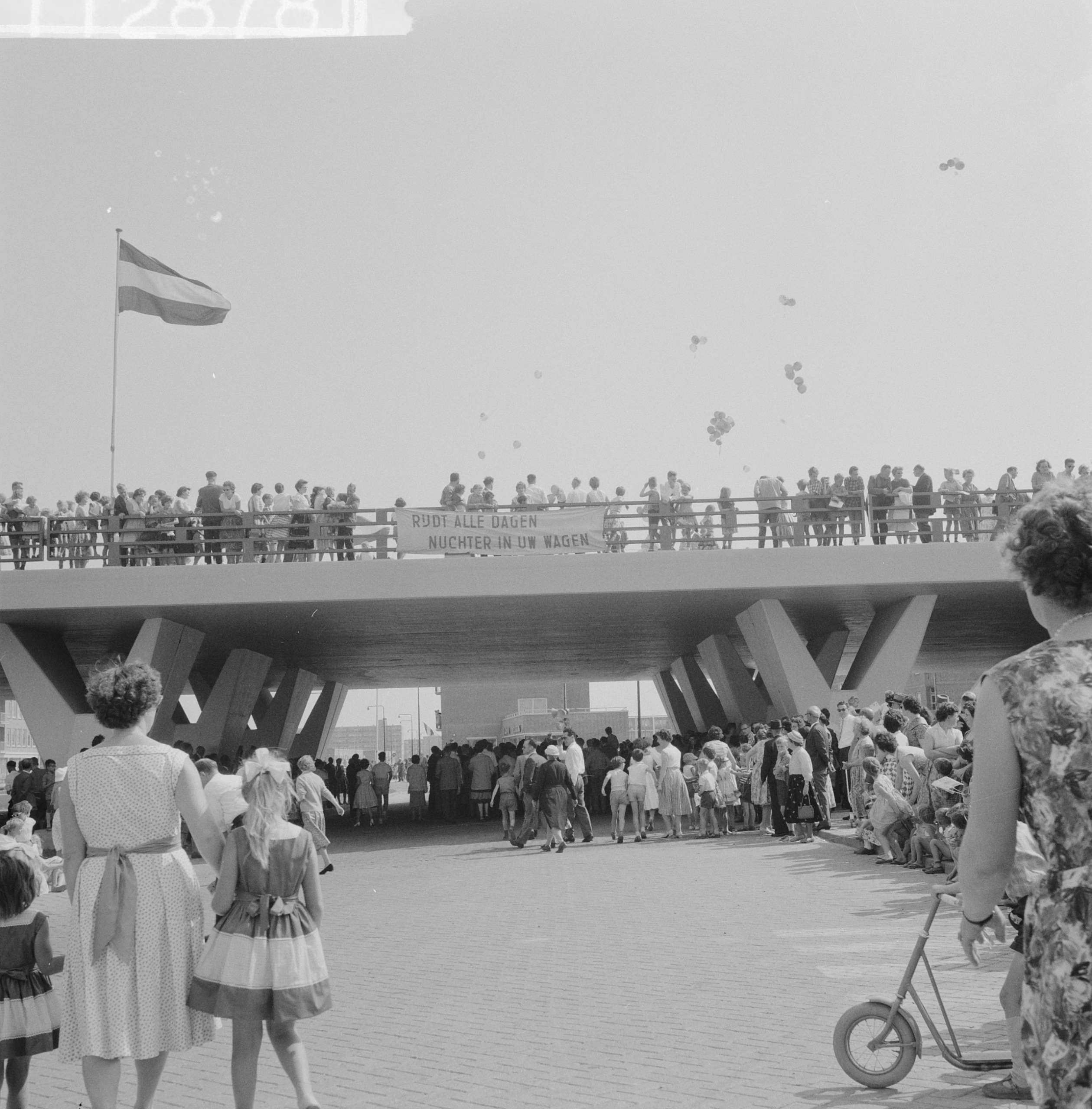
The other name that runs through these districts is Dirk Sterenberg, architect and sculptor. His viaduct, bridge 705, carries the Cornelis Lelylaan and its trams over the Johan Huizingalaan on 24 white V-shaped columns, with shops built into the walls beneath. According to the city it was the largest urban viaduct in Europe. Finished in 1960 and opened on 14 July 1962, it shows how quickly the plan could be overtaken. The tram to Osdorp along the Lelylaan was only decided in 1960, and because Publieke Werken and the transport company did not coordinate, the viaduct was built to its original design and its concrete deck had to be broken open soon afterwards to lay the rails.
On the far side of the Sloterplas, Sterenberg’s bridge 751 in Osdorp shows the confidence of the late 1950s. Built between November 1956 and September 1957 roughly where Van Eesteren’s 1939 map stops, it was meant to feed the Geer Ban, then planned as a main traffic artery. Between its railings it is 31.40 metres wide. A photograph from September 1958 shows two cars on it. The Geer Ban has since been turned into a residential street.
Buitenveldert: “Go and Look at Buitenveldert”
The southern garden city came last. The first stone was laid on 2 June 1958, and Van Eesteren went to live there himself. He is credited with saying that anyone who wanted to know how he meant the General Extension Plan should go and look at Buitenveldert.
Its bridges are the eight hundreds, starting with 801, 802 and 803 in 1961. Bridge 801 was designed by the architect Peter Pennink for Publieke Werken. Through the middle of the district runs the Gijsbrecht van Aemstelpark, a green link between the Amsterdamse Bos and the Amstelpark, and Sterenberg was given all its foot and cycle bridges. Where the Buitenveldertselaan crosses the park he designed the Gwijde van Henegouwenbrug, bridge 805, of 1960 to 1962, with sculptural piers and enough strength to carry a planned metro line. A tram and light-rail line was laid over it instead in 1989 and 1990. Around the park he drew about ten bridges to a common pattern, among them the Liesbeth den Uylbrug, bridge 834 of 1965 and 1966. The central part of the park, designed by Wim Boer, has been a rijksmonument (national monument) since 2015, and the protection includes its bridges.
How the Plan Shows Up in the Register
Read the Wikipedia articles on these number ranges together and a pattern appears. The low six hundreds are Slotermeer and Geuzenveld, beginning with Kramer’s bridges of 1951, and the series continues into the Sloterpark. Bridge 701 opens Slotervaart and the run up to about 722 stays there and along the Lelylaan. From 751 into the mid seven hundreds the bridges are in Osdorp. The eight hundreds begin in Buitenveldert in 1961. After that the series scatters, as the city’s growth did: bridges of the 1970s in Zuid around the ring road and the RAI, a handful in Zuidoost, and a set in Amsterdam-Noord from 1968 and 1969 at the end of the range.
The numbers were issued in series, area by area, as the districts were built, and the article on bridges 691 and 692 notes that their date can be read from their numbers. The ranges are not watertight. Some numbers were never used, some were reused after a demolition, as with 624, 633 and 877, and bridge 809 is a footbridge of the 2010s that filled an empty slot in a series issued decades earlier. Brug 85 is this site’s clearest case of a number that wandered. The numbers are not a count either. When Han Lammers opened three footbridges into the Rembrandtpark on 2 April 1974, the widest was celebrated as the “Duizendste brug”, the thousandth bridge. Its number is 684. How many bridges Amsterdam actually has goes into what the register can and cannot tell you.
Revising the Plan: Bijlmermeer and the Compact City
The forecasts proved too high, but the demand for homes still outran the plan, mainly because fewer people were living in larger homes. The Structuurplan Noord of 1958 opened up Amsterdam-Noord once the Coentunnel and IJtunnel were coming. The Structuurplan Amsterdam-Zuid en Zuidoost of 1965 produced the Bijlmermeer, designed by a team in the same urban development section under Siegfried Nassuth and begun in 1966. It took the functional city further than the garden cities had. Car, cycle and pedestrian traffic were strictly separated, with raised roads called dreven above paths at ground level, so it needed a bridge or viaduct at almost every crossing. A viaduct in Zuidoost in those years, as the article on bridge 855 puts it, meant almost automatically a design by Sterenberg. At the Meibergdreef three of his viaducts, among them bridge 871, stack a crossing for cars above one for cycles and pedestrians.
By then the city’s thinking had turned. Amsterdam lost about a quarter of its population between 1959 and 1984, falling from around 850,000 to around 640,000, while tens of thousands waited urgently for housing, and urban renewal showed that not everyone wanted to live in light and air. The city government that took office in 1978 adopted the compact city: build densely within the existing city and mix homes, work and recreation instead of separating them. Its first new project was the Venserpolder in Zuidoost in the early 1980s. De Aker, built in the 1990s west of Osdorp, finished off the seven hundreds three decades after they began: the Boy Ecurybrug, bridge 788, belongs to a series of around 1990 by N. Wijnmaalen for Publieke Werken and its successor, Openbare Werken.
Demolition and Restructuring
As the housing aged, the city began in the 1990s to plan the demolition and rebuilding of parts of the garden cities. In 2001 Bureau Parkstad published Richting Parkstad 2015, which planned to demolish about 13,000 homes and build about 24,000; the two Wikipedia articles give slightly different totals. By 2015 roughly half had been done. After the financial crisis, many cleared sites lay empty for years.
The restructuring reached the bridges mainly through the roads, which had been built for traffic forecasts that never arrived. Bridge 650, a large white viaduct by Slebos on four V-shaped columns, was built in the late 1950s for the raised Burgemeester Röellstraat in Geuzenveld. The road did not follow, and for years children used the viaduct as a playground until tram 13 finally ran over it in 1974. In 2000 and 2001 the embankment was dug away, the street brought down to ground level and the viaduct demolished. Bridge 621 nearby, first designed around 1957 by Aldo van Eyck during a short spell at Publieke Werken, went at the same time and was rebuilt as a low culvert bridge.
Bridge 645, another Slebos viaduct, was built in 1962 and 1963 under the planned Abraham Kuyperlaan motorway and lay unused until that road was completed in 1984. About twelve years later the city changed its traffic policy, the embankment was dug away, and the viaduct went with it. Elsewhere bridges went with the buildings they served: Sterenberg’s bridge 694 was demolished after the Andreas Hospital it led to was pulled down in 2005. In Zuidoost, the renewal of the Bijlmermeer replaced most of the honeycomb flats and removed their walkway bridges, and Sterenberg’s bridge 855 had already gone in the 1990s to make way for the Johan Cruijff ArenA.
Not everything was cleared. Part of Slotermeer was designated a protected cityscape in 2007, though large-scale demolition elsewhere in the district was approved two years later, and in March 2024 the whole Sloterplas and its banks became a municipal protected cityscape. From 2016 the city invited residents to name its anonymous bridges, and many of the crossings in this article, known for sixty years only by their numbers, now carry the names of resistance fighters, writers and local figures.
Reading the AUP on This Site
When an entry here describes a bridge in Nieuw-West or Buitenveldert as built for the General Extension Plan, it means the bridge belongs to a district laid out under the AUP and its partial plans, and was almost certainly drawn at Publieke Werken. In the 1950s and 1960s that usually means Slebos or Sterenberg, with Kramer at the very start and occasional work by Pennink and others. Where the sources name only the department, this site says so. The posts for these neighbourhoods will appear in the bridge index as they are published.
Sources Consulted
- Algemeen Uitbreidingsplan, Nederlandstalige Wikipedia
- Cornelis van Eesteren, Nederlandstalige Wikipedia
- Jakoba (Ko) Mulder, Nederlandstalige Wikipedia
- Groene Scheggen, Nederlandstalige Wikipedia
- Westelijke Tuinsteden, Nederlandstalige Wikipedia
- Sloterplas, Nederlandstalige Wikipedia
- Slotermeer (tuinstad), Nederlandstalige Wikipedia
- Geuzenveld, Nederlandstalige Wikipedia
- Slotervaart (tuinstad), Nederlandstalige Wikipedia
- Osdorp (tuinstad), Nederlandstalige Wikipedia
- Buitenveldert (tuinstad), Nederlandstalige Wikipedia
- Bijlmermeer (Amsterdam), Nederlandstalige Wikipedia
- Compacte stad, Nederlandstalige Wikipedia
- Lijst van bruggen in Amsterdam, Nederlandstalige Wikipedia
- Bridge articles, Nederlandstalige Wikipedia: Frieda Belinfantebrug (600), Hannie Schaftbrug (601), Tineke Guilonardbrug (611), Dirk de Waterduikerbrug (617), Brug 621, Brug 627, Brug 645, Brug 650, Duizendste brug (684), Brug 691, Brug 694, Bloeddonorbrug (701), Brug 705, Frans van Goolbrug (709), Piet Römerbrug (711), Brug 751, Boy Ecurybrug (788), Brug 801, Gwijde van Henegouwenbrug (805), Brug 809, Liesbeth den Uylbrug (834), Brug 855, Meibergdreefbrug-West (871), Brug 876
- Dirk Sterenberg, Nederlandstalige Wikipedia
- Dick Slebos (architect), Nederlandstalige Wikipedia
- Rijksmonumentenregister, monument 532136: Gijsbrecht van Aemstelpark
- Featured image: crowds on bridge 705, the viaduct over the Johan Huizingalaan, 4 June 1960, Wim van Rossem for Anefo, Nationaal Archief, CC0