If you stand at the intersection of the Leidsegracht and look toward the Amstel, you will notice a striking anomaly in Amsterdam’s urban fabric. In a city defined by its dense web of over 1,500 bridges, there is a massive, spanning silence on the Herengracht. Between Bridge 22 (Koningsluis) and Bridge 24 (Vijzelstraat), the water remains an unbroken mirror for nearly 350 meters.
This stretch is the Gouden Bocht—the Golden Bend. It is the most prestigious real estate in the Netherlands, yet it is functionally an architectural “void” in terms of maritime crossings. This was no topographical accident; it was a calculated victory for the 17th-century elite over the city’s Public Works Department (Publieke Werken).
The Urban Planning of Privilege
During the Fourth Expansion of Amsterdam in the mid-1600s, the city’s master planners, including Daniël Stalpaert, initially envisioned a more democratic distribution of infrastructure. Standard planning dictated that bridges should occur at regular intervals to allow for the flow of horse-drawn carriages and pedestrian commerce.
However, the Golden Bend was settled by the “Regenten”—the merchant-kings of the Dutch East India Company (VOC) and the city’s ruling burgomasters. To these residents, a bridge was not a convenience; it was a threat to their carefully constructed social theater.

The Three Reasons for the “Bridge Ban”
The wealthy homeowners of the Herengracht successfully lobbied the city council to keep bridges away from their front doors for three specific reasons:
The Privacy of the “Stoep”: In the 17th century, the elevated stone entrance (stoep) of a canal house was a stage for social status. Bridges brought foot traffic, street vendors, and the “lower classes” directly to one’s eye level. By preventing a bridge, the elite ensured that only those with business at their specific address would linger on their quay.
Unobstructed Vistas: Architecture was a weapon of prestige. Families like the Coymans and the Six spent fortunes on symmetrical, double-wide sandstone facades. A high arched bridge would physically block the view of these “palaces” from the water and, conversely, spoil the residents’ view of the reflecting canal.
Security and Silence: Bridges were noisy. The iron-rimmed wheels of carts and the clatter of horses on stone echoed between the high facades. By eliminating crossings, the Golden Bend became a “private” acoustic zone, isolated from the industrial clamor of the nearby Leidseplein and Spiegelstraat.
The Engineering Consequence: The Long Walk
The result of this 17th-century lobbying is still felt by modern pedestrians today. If you are walking along the Golden Bend and realize you need to cross to the other side of the Herengracht, you are forced to walk nearly 350 meters to the nearest crossing. In the dense center of Amsterdam, this is one of the longest “bridge-free” stretches in the entire canal ring.
Historical Footnote: The Bridge that Never Was
Archives from the Publieke Werken suggest that a bridge was originally considered for the intersection of the Nieuwe Spiegelstraat and the Herengracht. Had it been built, it would have fundamentally changed the character of the Golden Bend, turning it into a major transit artery rather than the secluded sanctuary of power it remains today.
Today, the lack of a bridge serves as a silent monument to the political “clout” of the Golden Age elite. They didn’t just own the houses; they controlled the very flow of the city itself.
The “Commercial Gap” and the Contrast of Bridge 34
While the Golden Bend (situated between Leidsestraat and Vijzelstraat) remained a silent sanctuary, the urban fabric changes drastically as one moves toward the Utrechtsestraat. Here, the presence of Bridge 34 (the Utrechtsestraatbrug) serves as a perfect historical foil to the empty quays of the elite.
The Utrechtsestraat was planned as a bustling commercial artery, a “working” street designed for the flow of goods and laborers. In the eyes of the Public Works Department, a bridge here was a functional necessity for the city’s metabolism. By comparing the dense traffic of Bridge 34 to the “Bridge Ban” of the Golden Bend, we see a clear 17th-century class divide written into the infrastructure: bridges were for the economy, but the absence of bridges was for the aristocracy.
Hydraulic Engineering: Sluices and Water Management
The archives of the Publieke Werken reveal that the lack of bridges in the Golden Bend wasn’t solely a social choice; it was also a matter of hydraulic complexity. This section of the Herengracht sits in close proximity to the Amstel River, meaning the water pressure and flow were significantly higher than in the smaller, secondary canals.
Building a bridge in this era often meant building a Sluis (lock or sluice) to manage water levels. Constructing a massive stone sluice in the Golden Bend would have required extensive pile driving and heavy masonry that would have disrupted the foundations of the adjacent mansions. For the wealthy residents, the risk of their palatial homes sinking or cracking during the construction of a municipal lock was a powerful technical argument used to keep the canal “unbroken.”
The “Double-Wide” Plot and the Logistics of Exclusion
One of the most striking architectural features of the Golden Bend is the scale of the plots. While a standard Amsterdam canal house was roughly 6 to 9 meters wide, the “Regenten” of the Herengracht purchased double-width lots, often spanning 15 to 20 meters.
This extreme width created a logistical loophole for the homeowners. In denser parts of the city, a single bridge might serve thirty families; in the Golden Bend, that same bridge would only serve three or four. The homeowners argued that the “cost-to-benefit” ratio for the city was insufficient. By building their homes on such a massive scale, they effectively “priced out” the need for public infrastructure, ensuring that the water in front of their windows remained an ornamental mirror rather than a transit route.
The Modern Consequence: The Long Walk
The result of this 17th-century lobbying is still felt today. Pedestrians on the Golden Bend face one of the longest “bridge-free” stretches in the entire canal ring.
This stands in sharp contrast to the Utrechtsestraat nearby. As a “working” commercial artery, the Utrechtsestraat was granted Bridge 34 to facilitate the city’s metabolism. The contrast is clear: bridges were for the economy, but the absence of bridges was a luxury reserved for the powerful.
Historical Footnote: The Bridge That Never Was
Records suggest a bridge was originally considered for the intersection of the Nieuwe Spiegelstraat and the Herengracht. Had it been built, it would have turned the Golden Bend into a major transit artery. Instead, it remains a silent monument to a time when the “Regenten” didn’t just own the houses—they controlled the very flow of the city itself.
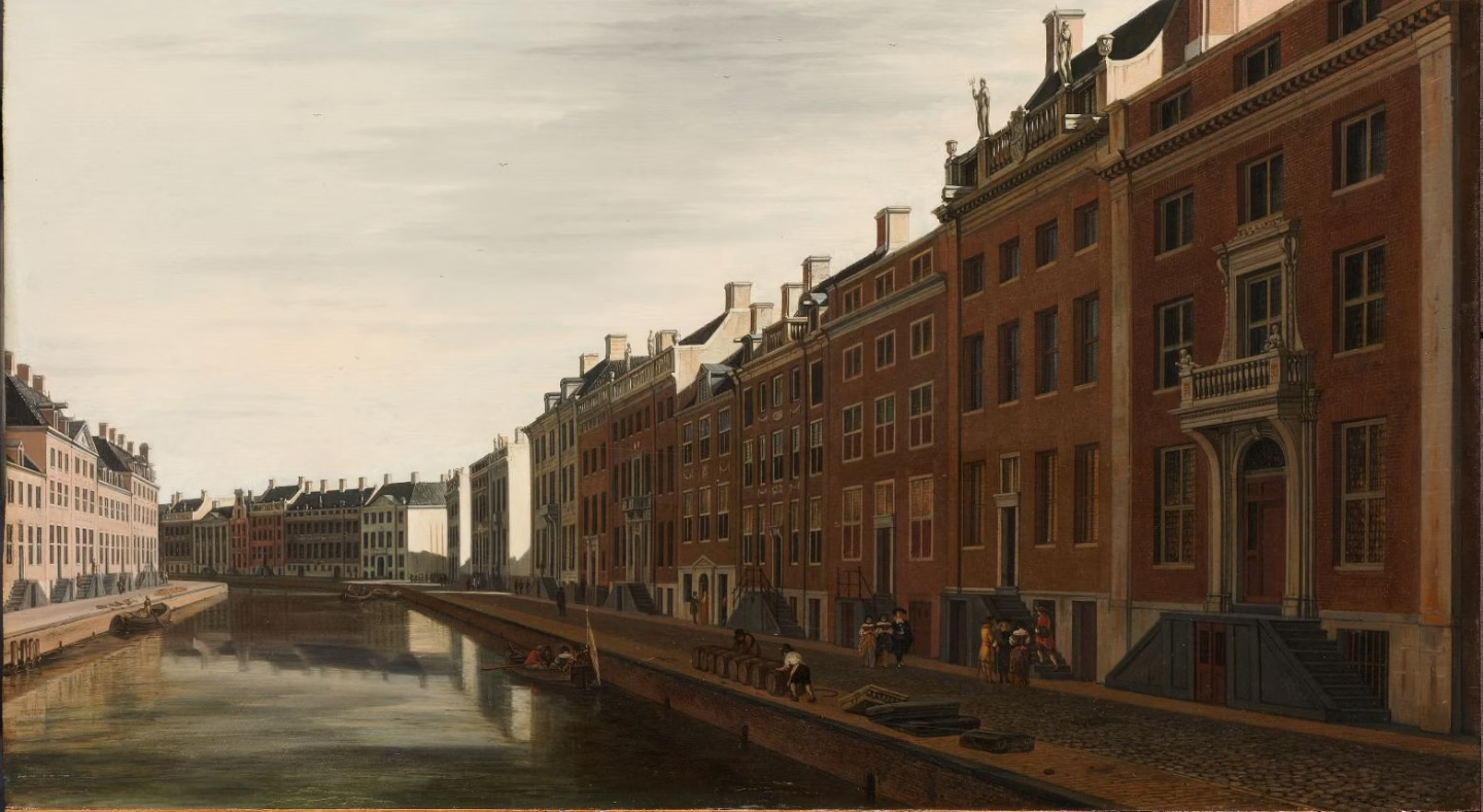
Public Domain Image Resources
To bring these technical points to life, I recommend the following high-resolution assets from the Rijksmuseum and City Archives:
The Ultimate Visual Proof: Gerrit Berckheyde, The Golden Bend (1672) – A view of the vast, bridge-free water.
The Technical Map: Daniel Stalpaert’s 1662 Map of Amsterdam – This shows the Fourth Expansion planning phase.
The Architectural Detail: Photo of Herengracht 446 (The Huis van der Graeff) – This illustrates the “double-wide” plot and the high “stoep” that residents wanted to protect from bridge traffic.
The Contrast: Historic Photo of Utrechtsestraat/Bridge 34 – Shows what a “busy” bridge looked like in contrast to the quiet Bend.