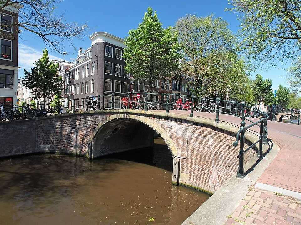
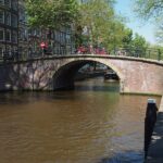
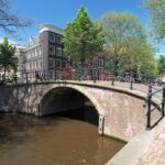
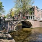
In a city where most historic bridges were brutally “flattened” (verlaagd) at the turn of the 20th century to make way for trams and automobiles, one small crossing refused to conform. Tucked away in the quiet Kerkstraat, where it spans the peaceful Reguliersgracht, Brug 74 stands as it has for over 240 years, its graceful stone arch still rising gently from the water. Known to locals as the Kerksluis or, more poetically, the Ronde brug (Round Bridge), this structure is a rare survivor, a living museum piece in Amsterdam’s ever-evolving urban landscape.
A Bridge of Many Names: From Church Lock to Perfect Circle
Brug 74 carries no single official name, but rather a collection of affectionate nicknames that speak to its history and character. The most common, Kerksluis, combines two elements: “Kerk” (church) from the Kerkstraat in which it lies, and “sluis,” an old Dutch term for a stone bridge . The name points to the nearby Amstelkerk, whose humble beginnings as a wooden temporary church on the Amstelveld are intertwined with the bridge’s own story.
But it is the second nickname, Ronde brug (Round Bridge), that reveals the bridge’s magical secret. Under perfect conditions, when the water is still and the light is right, the stone arch is reflected so perfectly in the Reguliersgracht that arch and reflection form a complete, flawless circle. It is one of Amsterdam’s most beloved and photographed optical illusions, a moment of geometric poetry that draws photographers from around the world to this quiet corner.
From Wooden Crossing to Stone Survivor: A 350-Year Evolution
The history of a bridge at this spot is nearly as old as the Canal District itself. The city architect Daniël Stalpaert included a bridge on his landmark 1662 map of Amsterdam, at a time when the area was still sparsely built. The temporary wooden Amstelkerk, however, was already standing . By 1688, the mapmaker Frederik de Wit showed both the growing neighborhood and the bridge, now firmly established in the Amstel Kerck Straet over the Reguliers Graft .
A fascinating drawing from around 1760 reveals that the bridge was then still a simple wooden structure without an arch . One of the quay sides was even used for storage, a reminder of the working waterfront that once characterized these canals.
The current bridge likely dates from 1780. This date is chiseled into two stone tablets on the north side of the bridge, reading simply “Anno” and “1780” . This was the moment the wooden crossing was replaced with the elegant stone arch we see today.
The Great Survival
What makes Brug 74 truly exceptional is what happened next. In the late 19th and early 20th centuries, Amsterdam launched a citywide campaign to lower and widen its ancient bridges. The old stone arches were deemed too steep for horse-drawn traffic and later automobiles. Most were demolished and replaced with flat iron girder bridges (liggerbruggen). But Brug 74 escaped this fate.
The reason was simple geography. The Kerkstraat, then as now, was a relatively quiet street. With little through traffic, there was no urgent need to spend public money on its alteration. As the Wikipedia article notes, “there was relatively little traffic here, hence they could wait a long time for an adjustment” . While bridges all around were being “flattened,” Brug 74 slept peacefully, its arch undisturbed.
A Gentle Modernization: The 1981 Renovation
By 1981, however, the old bridge needed attention. After two centuries of service, its fabric was wearing thin. But instead of replacing it with a modern design, the city chose a remarkably sensitive approach. They replaced the bridge deck with reinforced concrete and likely renewed the foundations, but the visible structure, the arch itself, was largely preserved .
This renovation was carried out by the Dienst der Publieke Werken, the same municipal department that had flattened so many other bridges. But here, they acted as conservators, not destroyers. The result is a bridge that looks authentically 18th century but has a hidden modern core, a perfect balance of history and safety. In 1995, this careful stewardship was recognized when the bridge was declared a gemeentelijk monument (municipal monument) .
The Quiet Heart of the Reguliersgracht: Urban Context
Brug 74 occupies a special place in Amsterdam’s geography. It lies in the Kerkstraat, a long street that runs parallel to the famous canals, and spans the Reguliersgracht, one of the city’s most picturesque waterways. The Reguliersgracht, with its seven bridges, is often called the “Venice of Amsterdam,” and Brug 74 is one of its jewels.
The bridge is surrounded by rijksmonumenten (national monuments) , but the most prominent landmark is the Amstelkerk on the nearby Amstelveld . This wooden church, initially built as a temporary structure in the 17th century, somehow survived to become a permanent and much-loved feature of the neighborhood. The bridge and the church, both survivors, keep each other company across the centuries.
Today, Brug 74 functions as a quiet pedestrian and cyclist route. It carries no trams and little car traffic. Its role is not to move crowds efficiently, but to offer a moment of beauty. It is, above all, a photographic vantage point, a place where people stop, cameras in hand, hoping to capture that perfect circle of arch and reflection.
Technical Specifications: The Arch That Reflects
Type: Vaste brug (Fixed bridge). A welfbrug (vault or arch bridge) with a single span.
Materials: The visible arch is original brick and stone from 1780. The deck was renewed in reinforced concrete in 1981. Stone tablets on the north side bear the date “Anno 1780”.
Dimensions: Doorvaarthoogte (clearance height) of 2.60 meters. Doorvaartbreedte (clearance width) of 6.78 meters .
Architect: Unknown 18th-century master builder; 1981 renovation by the Dienst der Publieke Werken.
Special Status: Gemeentelijk monument (municipal monument) since 1995.
Unique Feature: The optical illusion of a perfect circle formed by the arch and its reflection in the water.
The Kerksluis, the Round Bridge, Brug 74. Call it what you will, this small stone arch over the Reguliersgracht is a treasure. It is a bridge that refused to be modernized out of existence, a survivor that now offers one of the most magical views in Amsterdam. It reminds us that sometimes the best path forward is to preserve the beauty of the past.
Sources and Further Reading
Primary Sources & Archival References
Stadsarchief Amsterdam (Amsterdam City Archives)
Archief van de Publieke Werken (Public Works Department archives), dossiers betreffende de renovatie van brug 74, 1981.
Bouw- en vergunningstekeningen (Building and permit drawings) for the 1981 renovation.
Historische tekeningen: Drawing of the wooden bridge, circa 1760.
Cartographic Sources
Stalpaert, Daniël (1662). Nieuwe kaarte van de stede Amsterdam. Stadsarchief Amsterdam.
De Wit, Frederik (1688). Kaart van Amsterdam. Stadsarchief Amsterdam.
Municipal Registries & Official Documents
Basisregistratie Adressen en Gebouwen (BAG), gemeente Amsterdam. Entry for Brug 74 via data.amsterdam.nl.
Gemeentelijk Monumentenregister (Municipal Monument Registry), entry for Brug 74 (since 1995).
Rijksmonumentenregister (National Monument Registry), entries for surrounding buildings including the Amstelkerk.
Online Databases & Historical Websites
Wikipedia contributors. (2025, December 29). “Brug 74 (Amsterdam).” Wikipedia, De vrije encyclopedie. https://nl.wikipedia.org/wiki/Brug_74
Korrel, Peter. “Brug 74 in de Kerkstraat over de Reguliersgracht.” Bruggen van Amsterdam. https://bruggenvanamsterdam.nl/ (Search for Brug 74).
data.amsterdam.nl. Entry for Brug 74 via Basisregistratie Adressen en Gebouwen (BAG).
Historical Context & Further Reading
Smit, Frank V. (2008). Bruggen in Amsterdam. Uitgeverij Matrijs. (Provides context on the history and design of Amsterdam’s bridges, including the Reguliersgracht crossings).
Gawronski, J., & Veenman, R. (2018). *De Amsterdamse bruggen: Bouw en ontwikkeling 1850-1950*. Uitgeverij Thoth. (For understanding the broader trend of bridge lowering that Brug 74 escaped).
Mak, Geert. (1995). Een kleine geschiedenis van Amsterdam. Uitgeverij Atlas. (Essential context for the development of the Reguliersgracht and Amstelveld area).
Bakker, T., et al. (2004). Amsterdam in de 17de eeuw. Stadsuitgeverij Amsterdam. (For understanding the early development of the Kerkstraat and Reguliersgracht).
Image Collections
Wikimedia Commons. “Categorie: Brug 74, Kerksluis.” https://commons.wikimedia.org/wiki/Category:Brug_74,_Kerksluis
Beeldbank Stadsarchief Amsterdam. Photographs of Brug 74 and the surrounding area, various dates. https://archief.amsterdam/beeldbank/