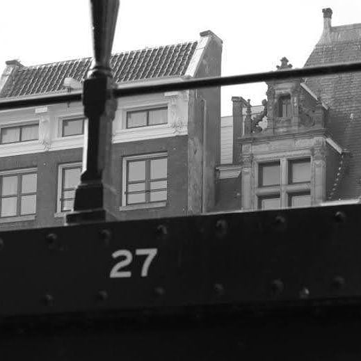
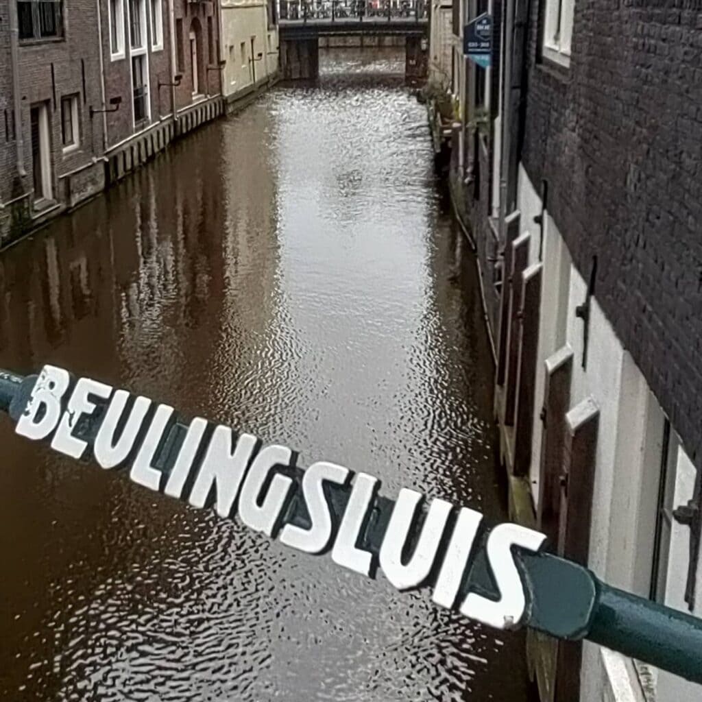
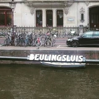
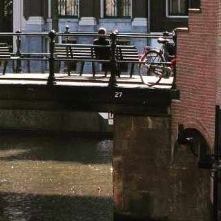
Bridge number 27 (De Beulingsluis) brug nummer 27
It’s been quite some time since we last had a bridge bearing a name. For those with keen observation, you may have already caught a glimpse of this particular bridge when we covered Krijtbergsluis (Bridge number 3) since it stands at the opposite end of the Beulingsloot.
Numbers 27 and 3 were nearly nonexistent due to the Beulingsloot “ditch” almost being completely filled in, rendering the bridges at either end obsolete. However, through some fortunate circumstances, both bridges have managed to remain in use.
The Beulingsloot was probably named after one of the residents of a nearby building, Gerrit Jansz. Beulinck, who had a building here around 1660 where “de Beuling” (sausage) hung. The canal has also been known as the Leerouwers- en Huidevettersloot. The canal is not accessible for motorised shipping traffic, and even non-motorised shipping traffic actually has one-way traffic from Singel to Herengracht, on bridge 27 there is a sign A1 of the Inland shipping policy regulations. The houses of the Beulingssloot are directly on the water. The Beulingsloot derives its name from one of the residents, Gerrit Jansz. Beulinck, who had a building nearby during the 1660s where “de Beuling” (sausage) was commonly hung. The canal is also known as the Leerouwers- en Huidevettersloot. Notably, the Beulingsloot is inaccessible for motorised shipping traffic, and even non-motorised ships must follow a one-way traffic pattern from Singel to Herengracht. A sign with the code A1 of the Inland Shipping Policy Regulations can be found at bridge 27. The houses lining the Beulingsloot offer direct waterfront views.
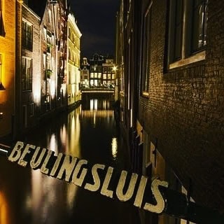
De Beulingsluis: Bridge 27 and the Sausage Maker Who Named a Canal
A Fixed Bridge Where the Herengracht Meets One of Amsterdam’s Oldest Waterways
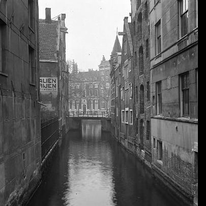
Most crossings in Amsterdam span the city’s famous concentric canals. Bridge 27 is different. The Beulingsluis marks the end of the Beulingsloot’s short 50-metre run from the Singel, joining the Herengracht about halfway down its journey from the River Amstel. It is not a bridge over a great canal, but a bridge at the mouth of one of the oldest and most intimate waterways in the city, a place where a medieval drainage ditch meets a Golden Age masterpiece, and where a man who once hung sausages from a doorpost has had his name preserved in stone and water for over three and a half centuries.
1. Etymology and Naming: A Sausage, a Sign, and a Street That Remembers
The name of Bridge 27 is inseparable from the name of the canal it spans, and both ultimately trace back to a single Amsterdam resident of the 17th century. The bridge is named after Gerrit Jansz. Beulinck, who lived here around 1660, and outside whose premises a beuling (a type of sausage) was hung as a trade sign.
This was standard commercial practice in a city that predated street numbering: a merchant or tradesman would hang an object from their building to indicate their trade, and neighbours and customers would refer to the location by that sign. According to historian J.A. Wiersma, writing in “De naam van onze straat” (1987), the name of the Beulingsloot derives from this former resident. Gerrit Jansz. Beulinck made his presence known by a hanging sign showing “de Beuling.” The sausage sign became a local landmark, the local landmark became a name, and the name passed first to the canal, then to the bridge.
The canal itself, however, has a much deeper history than the man who named it. The Beulingsloot is one of the oldest and shortest canals in Amsterdam-Centrum, located within the Grachtengordel. According to the Historische Gids van Amsterdam, the canal was previously also known as the Herendwarsburgwal or Heere Dwars Burchwal, from the time when the Herengracht was still the city’s outermost canal. This earlier name preserves the memory of the canal’s role as a transverse ditch cutting across the medieval water management system, predating the Golden Age expansion entirely.
The canal appears on the city plan of Pieter Bast from 1599, at which point it is shown as an outer waterway on the periphery of the pre-expansion city. The canal also acquired the names Huidenvetters- and Looierssloot, reflecting the tanning industries that operated along its banks in earlier centuries. Jan ter Gouw documented this industrial history in his “Amsterdam en Amstelodamiana” in 1865 and 1877. The sequence of names the canal has carried, from a transverse ditch to a tanners’ waterway to a sausage-maker’s memorial, is a compressed history of how Amsterdam’s inner city transformed from craft district to residential and commercial neighbourhood across three centuries.
The word “sluis” in the bridge’s name requires a note. In modern Dutch, sluis typically means lock or sluice. In this context, however, sluis means stenen brug: a stone bridge. The Beulingsluis is not and was not a lock in the hydrological sense. It is a stone crossing, and the older usage of the word “sluis” to mean any substantial fixed stone bridge is an important historical distinction that prevents the name from being misread.
2. Structural Evolution: Seen on Stalpaert’s Map of 1662, Renewed around 1900
The cartographic record for Bridge 27 is remarkably well established. The Beulingsloot itself is already visible on the Pieter Bast map of 1599. The bridge, however, first appears in the formal documentary record a little later. The Beulingsluis is visible on the design map of city architect Daniël Stalpaert from around 1662.
Stalpaert was one of the most significant figures in 17th-century Amsterdam’s built environment. He was appointed city architect on 29 October 1648, and his main tasks included directing the construction of the new Town Hall on Dam Square and overseeing the 1662 urban expansion plan for Amsterdam. His map of 1662, a large engraved wall map on six sheets commissioned by the city, shows Amsterdam at the height of its Golden Age expansion, with the great Three Canals Project nearing completion. The Beulingsluis appears on that map as a crossing already integrated into the fabric of the canal belt, a detail that confirms the bridge had been in place as the neighbourhood around it was being built.
A photograph from 1884, held in the Stadsarchief Amsterdam, shows the Herengracht looking north toward the then-named Vingboomsbrug (Bridge 26), with the Beulingsluis (Bridge 27) visible to the right over the Beulingsloot, flanked by the houses at Herengracht 395 to 397. That image captures the bridge in its 19th-century form, shortly before renewal.
The current bridge structure likely dates from around 1900, when the bridge was halted for repair work or renewal. The transition from whatever earlier form the bridge held to the flat plate bridge visible today was part of the broader city-wide programme of replacing high arched canal crossings with flat fixed structures to accommodate modern traffic.
Critically, both Bridge 27 and the Krijtbergsluis (Bridge 3 at the Singel end of the same canal) came close to disappearing entirely in this period. In the 1910s and 1920s there were plans to fill in the Beulingsloot entirely and demolish the structures along it. Those plans came to nothing. In the hundred years that followed, the idea of filling the canal was never raised again. The canal and both its bridges survived by the narrowest of margins.
An 1884 photograph in the Stadsarchief Beeldbank shows the bridge from the Herengracht, captioned: “De Herengracht gezien in noordelijke richting naar de Vingboomsbrug (Brug 26), met rechts de Beulingsluis (Brug 27) over de Beulingsloot en ter weerszijden van de brug de huizen Herengracht 395–397.” This is one of the most precise archival records of the bridge’s pre-renewal appearance and its relationship to the surrounding streetscape.
3. Architectural Lineage: A Typical Plate Bridge of Publieke Werken
The Beulingsluis is a typical “Plaatbrug” (plate bridge), a flat fixed bridge of the type found throughout Amsterdam’s canal network. No individual architect is named in connection with Bridge 27 in any source consulted for this post, and the design is attributed to the Dienst der Publieke Werken in the standard municipal records.
The bridge predates or is contemporary with the early phase of the Amsterdam School’s influence at Publieke Werken. Piet Kramer was appointed aesthetic adviser to the bridges division only in 1917, and Johan van der Mey in 1911. The renewal of Bridge 27 around 1900 therefore sits just outside the period when decorative masonry, custom wrought iron railings, granite nose stones, and integrated sculptural programmes became the distinguishing features of new Amsterdam bridges.
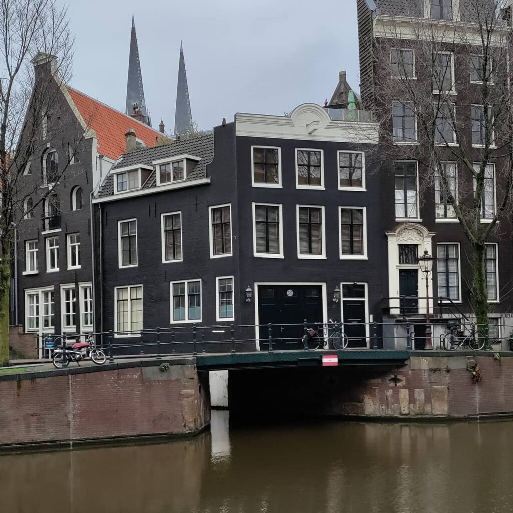
What Bridge 27 does possess is a setting that few bridges in the city can rival. Standing on the bridge and looking back down the Beulingsloot, one has a direct view along the full 50-metre length of the canal toward the Singel, with the rear facades of the Beulingstraat houses on one side and the Dubbelworststeeg houses on the other. Looking the other way from the bridge deck, across the Herengracht, the view of the canal in both directions is one of the most composed in this part of the inner city. There is also one unmissable modern detail. A Space Invader mosaic artwork is visible on the left abutment of the bridge when looking down the Beulingsloot. The work is part of the long-running international street art project by the anonymous French artist known as Invader, who has placed ceramic tile artworks in cities worldwide. Its presence on a 17th-century canal bridge in the heart of the UNESCO World Heritage zone is an entirely typical piece of Amsterdam urban texture.
4. Urban and Social Context: The Spui, the Krijtberg, and One of Amsterdam’s Quietest Canal Views
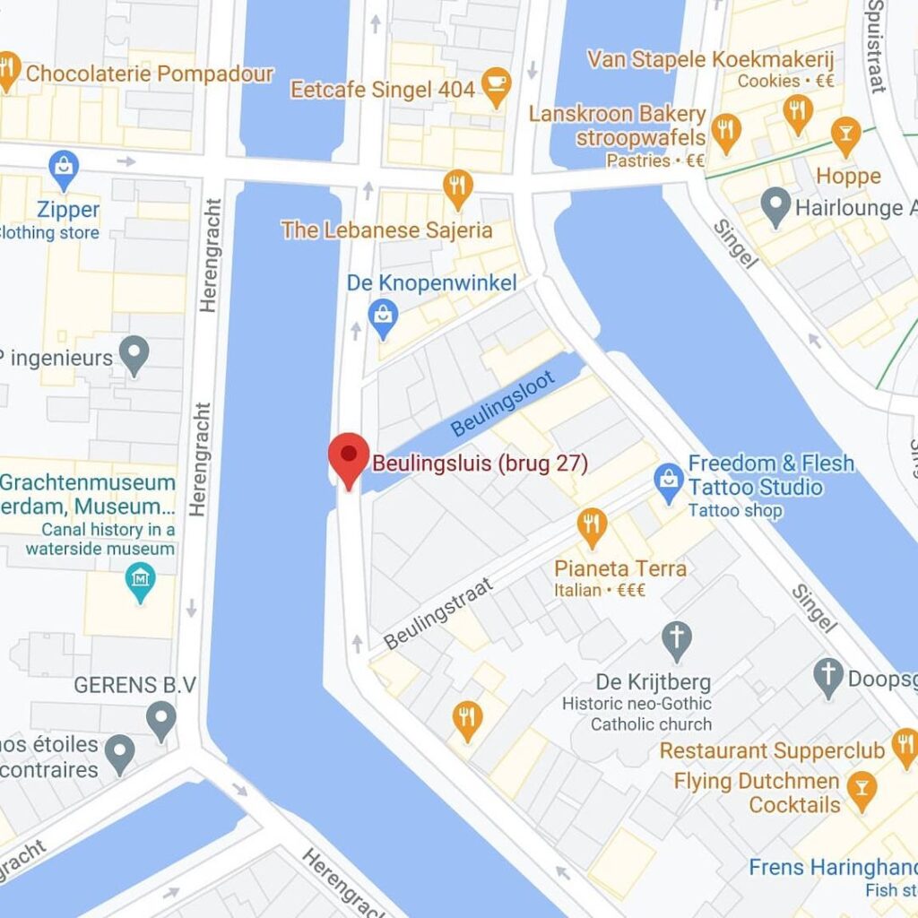
The Beulingsloot runs from the Singel to the Herengracht near the Spui, with a length of only 50 metres, making it one of the shortest canals in Amsterdam. This compact geography places Bridge 27 in one of the most historically dense parts of the inner city.
Immediately behind it, rising from the Singel side of the canal, stands the Krijtberg, the Roman Catholic church of St. Francis Xavier. A Stadsarchief photograph shows the Beulingsluis (Bridge 27) in the foreground with the R.K. kerk De Krijtberg visible on the right in the background. The Krijtberg’s neo-Gothic facade, completed in 1883, provides the visual backdrop to the view looking west from the bridge down the length of the Beulingsloot, making this one of the more photogenic canal perspectives in the immediate neighbourhood.
On the other side of the Herengracht, visible from the bridge deck, are two important cultural sites. Bridge 27 offers a view of the Museum het Grachtenhuis and the Bijbels Museum across the water. The Cromhouthuizen at Herengracht 364 to 370, discussed in the Bridge 26 post, are also visible a short distance to the south.
The Beulingsloot itself is open to non-motorised boat traffic, but only in one direction. The Beulingsloot is not accessible for motorised vessel traffic. Even non-motorised traffic in practice moves in one direction only, from the Singel toward the Herengracht. At Bridge 27 on the Herengracht side, a sign indicating a traffic prohibition under the Inland Waterway Police Regulations is posted. This one-way arrangement makes the canal unusually quiet, reinforcing the sense of stepping back from the main waterway into an older and more intimate Amsterdam.
5. Technical Specifications
Based on confirmed sources, the following can be stated:
- Bridge type: Fixed plate bridge (vaste Plaatbrug)
- Location: In the northeastern quay of the Herengracht, spanning the Beulingsloot at its junction with the Herengracht, Amsterdam-Centrum
- Canal: Beulingsloot (one of the oldest and shortest canals in Amsterdam-Centrum, approximately 50 metres long)
- First documented: Visible on the design map of city architect Daniël Stalpaert, around 1662; the canal itself appears on the Pieter Bast city plan of 1599
- Current structure: Likely dates from around 1900, when the bridge was stopped for repair or renewal
- Designer: Dienst der Publieke Werken; no individual architect confirmed
- Amsterdam School attribution: None; the renewal predates or is contemporary with the earliest phase of Publieke Werken’s Amsterdam School period
- Notable feature: Space Invader ceramic tile mosaic on the left abutment
- Boat traffic: Non-motorised only, effectively one-way from Singel to Herengracht
- Threatened demolition: Plans to fill in the Beulingsloot and demolish the bridge were considered in the 1910s and 1920s but never executed
Sources Consulted
- Bruggenvanamsterdam.nl, bridge register entry for Brug 27: www.bruggenvanamsterdam.nl/herengracht.htm
- Wikipedia (nl), “Beulingsluis”: nl.wikipedia.org/wiki/Beulingsluis
- Wikipedia (nl), “Beulingsloot”: nl.wikipedia.org/wiki/Beulingsloot
- Bridges.cramberts.com, “De Beulingsluis, Bridge 27, History and information”: bridges.cramberts.com/2022/04/03/de-beulingsluis-bridge-27-history-and-information/
- Bridges.cramberts.com, “De Beulingsluis, Bridge 27, Map and location”: bridges.cramberts.com/2022/04/03/de-beulingsluis-bridge-27-map-and-location/
- Bridgesofamsterdam.com, “Bridge 27”: bridgesofamsterdam.com/bridges/27/
- MforAmsterdam Tours, “Beulingsloot”: mforamsterdam.com/beulingsloot/
- Wikimapia, “Beulingsluis”: wikimapia.org/37346377/Beulingsluis
- Wikipedia (en), “Daniël Stalpaert”: en.wikipedia.org/wiki/Dani%C3%ABl_Stalpaert
- J.A. Wiersma, “De naam van onze straat,” Amsterdam 1987, ISBN 9062740243 (cited in Wikipedia nl, “Beulingsloot”)
- Jan ter Gouw, “Amsterdam en Amstelodamiana,” 1865 and 1877 (cited in Wikipedia nl, “Beulingsloot”)
- Stadsarchief Amsterdam Beeldbank: archief.amsterdam/beeldbank/detail/429a42fd-b932-f42a-76c4-4d80b8453c4c and archief.amsterdam/beeldbank/detail/a04f90d0-fa65-5c93-af9f-1f8791caf76a
- Rijksmuseum collection, “Beulingsluis en de Beulingsloot in Amsterdam, gezien vanaf de Herengracht,” c. 1910 to 1930: rijksmuseum.nl/en/collection/RP-F-F01053-AK
Public Domain Images

1. “Beulingsluis en de Beulingsloot in Amsterdam, gezien vanaf de Herengracht,” anonymous, c. 1910 to 1930 A gelatin silver print, 130mm by 165mm, from an album of Amsterdam photographs, held in the Rijksmuseum collection. Object number RP-F-F01053-AK. Copyright status: Public domain. This image shows the bridge and the full length of the Beulingsloot viewed from the Herengracht, and is one of the most direct visual records of the early 20th-century bridge. URL: https://www.rijksmuseum.nl/en/collection/RP-F-F01053-AK Attribution: “Anonymous, c. 1910 to 1930. Rijksmuseum Amsterdam, Object RP-F-F01053-AK. Public domain.”

2. Stadsarchief Amsterdam Beeldbank: “Beulingsloot en Beulingsluis (Brug 27), gezien van Herengracht naar Singel” This photograph shows the view from the Herengracht along the Beulingsloot toward the Singel, with Herengracht 395 on the left and 397 on the right. Available via the Stadsarchief Beeldbank. Images from the Stadsarchief collection are generally available for non-commercial use with attribution. URL: https://archief.amsterdam/beeldbank/detail/429a42fd-b932-f42a-76c4-4d80b8453c4c Attribution: “Collectie Stadsarchief Amsterdam.”

3. Stadsarchief Amsterdam Beeldbank: “Heerengracht bij de Beulingsluis, 1884” This photograph, captioned “De Herengracht gezien in noordelijke richting naar de Vingboomsbrug (Brug 26), met rechts de Beulingsluis (Brug 27) over de Beulingsloot en ter weerszijden van de brug de huizen Herengracht 395–397,” shows the bridge in its pre-renewal 19th-century form. Available via the Stadsarchief Beeldbank. URL: https://archief.amsterdam/beeldbank/detail/a04f90d0-fa65-5c93-af9f-1f8791caf76a Attribution: “Collectie Stadsarchief Amsterdam, 1884.”
Map of Brug 27
De Beulingsluis is located across the Beulingsloot alongside the northeastern quay of Herengracht in the canal belt of Amsterdam. At the opposite end of the Beulingsloot is Krijtbergsluis Brug 3
The Execution Lock Bridge: A Historic Crossing on Amsterdam’s Canals
Gracefully spanning the Beulingsloot within Amsterdam’s ring of canals, the Execution Lock Bridge finds its place along the northeastern quay of the illustrious Herengracht. This bridge’s historical significance dates back centuries, with its existence captured on Daniel Stalpaert’s map from around 1662. The current structure likely emerged in the early 1900s when it underwent necessary repairs or renewal, adhering to the timeless design of a typical “Plate Bridge.”
An Enduring Link:
The Beulingsluis Bridge stands as a testament to Amsterdam’s rich history, serving as a crucial crossing over the Execution Lock for generations of residents and visitors. Its presence on Stalpaert’s map underscores its enduring importance to the city’s infrastructure.
A Distinctive Design:
As a quintessential “Plate Bridge,” the Execution Lock Bridge showcases the architectural style commonly found in Amsterdam’s canal network. This design, characterised by its practicality and functionality, has stood the test of time, continuing to provide a reliable passageway for pedestrians and vehicles alike.
A Canal Network’s Tale:
Across the Beulingsloot, nestled within the Singel, lies the Krijtbergsluis. Like the Krijtberg Lock, the Execution Lock Bridge has weathered the passage of time, withstanding potential threats of demolition and canal dampening in the early 20th century. However, the plans to alter these areas fortunately remained unrealised, preserving the unique character of Amsterdam’s historic canal system for future generations.
A Testament to Preservation:
Over the years, the idea of damping the Beulingsloot and undertaking drastic demolitions was pondered, but ultimately, the city chose to safeguard the area’s charm and architectural heritage. As a result, the Execution Lock Bridge has stood firm, remaining a witness to Amsterdam’s ability to embrace modernity while cherishing its cherished past.
Conclusion:
The Beulingsluis Bridge serves as a timeless symbol of Amsterdam’s canal network’s resilience and historical significance. For centuries, it has connected the northeastern quay of the Herengracht, inviting locals and visitors to traverse its pathway and immerse themselves in the city’s rich tapestry of history. As Amsterdam continues to evolve, this bridge remains an enduring link to its illustrious past and a reminder of the city’s commitment to preserving its cultural and architectural treasures.

De Beulingsluis Brug 27 some history
The Beulingsloot, most likely named after Gerrit Jansz. Beulinck, one of the residents of a nearby building, had a building here around 1660 where “de Beuling” (sausage) was hung. The canal was also known as the Leertouwers- and Huidevetterssloot. It is believed that the name of the Beulingsloot originated from the presence of Gerrit Jansz. Beulinck’s building, which served as a location for hanging sausages. In addition to its association with sausages, the canal was also known by the names of Leertouwers- and Huidevetterssloot.