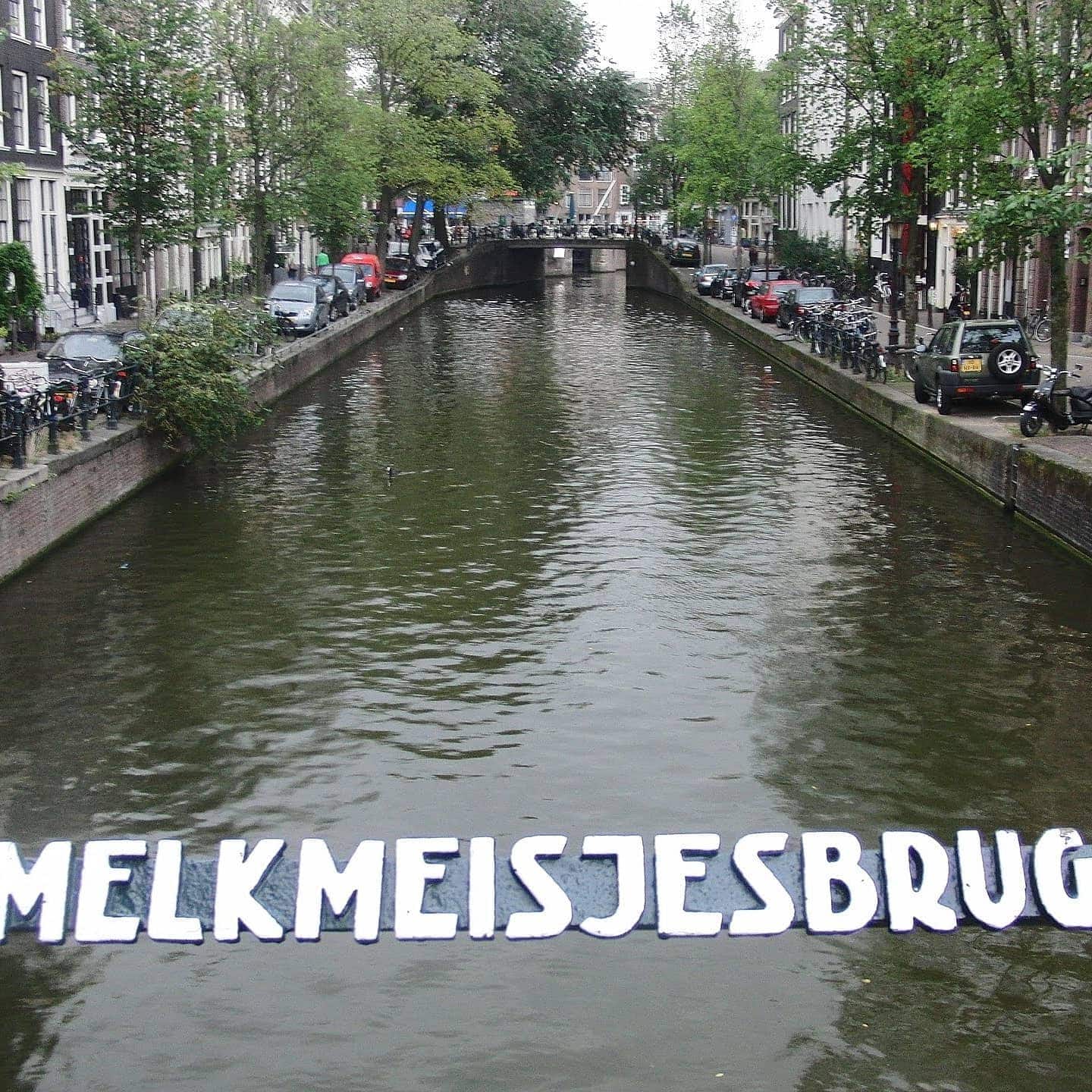
Melkmeisjesbrug (Milk maids bridge)
Bridge number 16 (Brug Zestien) is our first pedestrian bridge! Exciting. Yeah okay just me then. Also this marks a turning point, quite literally, as this bridge is off the Singel and we are now at the eastern quay of Herengracht as this bridge spans Brouwersgracht.
The bridge is named after the local milk market that used to be held around here. Later, a cafe used an image of a milkmaid as a signboard here cementing the naming. The bridge is also probably the place where the first Amsterdammertje was placed. More on that when I’ve had a chance to look it up but don’t expect too much because there are way too many of those to photograph.


The Milkmaid’s Bridge: A Story of Markets, Modernism, and the Amsterdammertje at the Head of the Herengracht
There is a particular kind of magic at the northern edge of Amsterdam’s Canal Belt. Here, where the grand Herengracht meets the Brouwersgracht, the city exhales. The crowds thin, the warehouses wear their centuries like a comfortable coat, and the light catches the water just so. At this precise confluence, you will find the Melkmeisjesbrug (Bridge 16), a slender steel footbridge that connects the elegant quays of the Herengracht to the historic Brouwersgracht. It is a bridge of quiet charm and surprising firsts, a place where the story of Amsterdam’s growth, its daily life, and even its street furniture, gently converge.
The Name’s Creamy Origins: From Milk Market to Melkmeisje
Unlike the purely functional designation of its neighbor, Brug 15, the Melkmeisjesbrug carries a name rich with the aroma of Amsterdam’s historical commerce. “Melkmeisjesbrug” translates directly to “Milkmaids’ Bridge,” and its origins are twofold, painting a vivid picture of the area’s past.
Firstly, the name is a direct reference to the milk market (melkmarkt) that was once held in this very spot. In the centuries before pasteurization and supermarkets, fresh milk was a daily necessity brought into the city by boat from the polders to the north. The Brouwersgracht, as a major artery for goods, was a logical point of entry. Farmers and their maids—the melkmeisjes—would moor their flat-bottomed boats, known as melkschuiten, at the head of the Herengracht. There, they would sell their fresh wares directly to the city’s housewives and cooks from open stalls or directly from the boat. This bustling, daily ritual of commerce gave the immediate area its nickname and, eventually, its bridge its name.
Secondly, the name was cemented in local lore by a later establishment. A café or tavern, capitalizing on the location’s history, adopted the milkmaid as its sign. The image of a smiling melkmeisje hanging above the door ensured that the name stuck, transitioning from a description of a market to a fixed geographical identifier. This charming evolution from working waterfront to urban legend is pure Amsterdam, where the city’s history is always just beneath the surface, ready to be recalled by a street name or a bridge’s moniker.
Four Centuries of Crossing: A Structural Evolution in Three Acts
The crossing at this point is almost as old as the canals themselves. The great cartographers of the Dutch Golden Age—Balthasar Florisz. van Berckenrode in 1625, Joan Blaeu in 1649, and Daniël Stalpaert in 1662—all meticulously recorded a bridge on this spot . For over 250 years, it was almost certainly a wooden drawbridge (ophaalbrug) , a necessary feature to allow masted ships to pass from the Brouwersgracht into the Herengracht, delivering not just milk, but timber, wine, and spices to the stately warehouses.
Act One: The Industrial Fix (1883)
The first great transformation came in 1883. As the maritime shipping industry modernized and the heart of the port moved east, the need for a movable bridge here diminished. The city made the pragmatic decision to replace the old wooden drawbridge with a fixed bridge. This was an era of iron and efficiency, and the new structure was designed for pedestrians and local cart traffic, no longer having to yield to the masts of cargo ships.
Act Two: The Elegant Engineer (1903)
Yet, this first fixed bridge proved to have its own flaw: the passage beneath it was too narrow. In 1903, a new design was implemented that must have been a striking sight. Engineers installed a “paraboolliggerbrug” (parabolic girder bridge) with graceful iron sickle-shaped girders . The Wikipedia article notes that the bridge looked slender and fit beautifully into the streetscape . This was the work of the city’s Publieke Werken (Public Works Department) at the turn of the century, a period of pragmatic but often elegant engineering that predated the more flamboyant artistic interventions of the Amsterdam School.
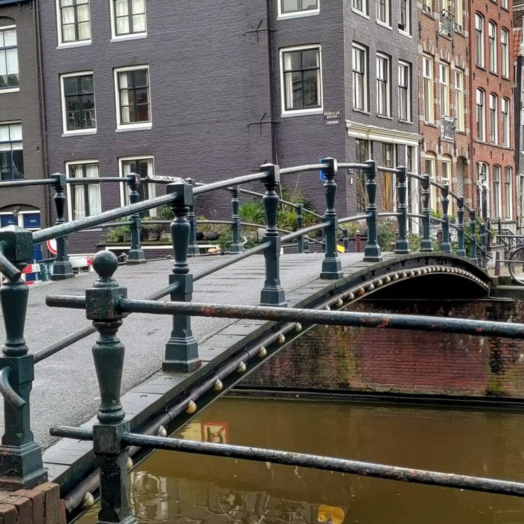
Act Three: Modernist Minimalism (1966)
The bridge we cross today is the third act in this story, dating from 1966. The current structure is a testament to mid-20th-century functionalism. It is a simple, fixed steel bridge designed for one purpose only: to serve pedestrians. Yet, in its simplicity, it echoes the elegance of its 1903 predecessor. Its low profile and clean lines do not compete with the monumental 17th-century warehouses that surround it. Instead, it acts as a quiet, respectful connector, proving that modernist design can coexist harmoniously with a centuries-old setting.
A Lineage of Function, Not Flamboyance
For those familiar with the sculptural bridges of Piet Kramer or the decorative flourishes of the Amsterdam School, the Melkmeisjesbrug offers a different kind of beauty. There are no carved granite “nose” stones, no elaborate wrought-iron railings depicting maritime scenes, and no whimsical bridge keeper’s houses. Its lineage traces back not to a celebrated architect, but to the city’s engineering department.
The 1903 bridge was the product of a municipal engineer’s quest for an optimal, elegant solution to a technical problem: how to span the water with a low, strong, and visually unobtrusive structure. The parabolic form was a hallmark of this period of bridge-building, a perfect marriage of mathematical efficiency and aesthetic grace. The 1966 replacement, built when the old iron bridge likely reached the end of its lifespan, maintained that spirit. It is a testament to the unsung heroes of Publieke Werken, the engineers and draftsmen who prioritized function but, in doing so, often achieved a timeless form.
The Confluence of Grandeur and Grit: Urban Context
Standing on the Melkmeisjesbrug is to occupy one of the most significant junctions in Amsterdam’s urban plan. You are at the very head of the Herengracht, the first and most prestigious of the city’s main canals, named after the “Heren” or lords who governed the city. To the south, it stretches in a gracious curve towards the Golden Bend. To the north, the Brouwersgracht opens up, lined with the massive, painted warehouses that once stored the goods of the Dutch East India Company (VOC), now converted into some of the city’s most desirable homes. All around you, both on the Herengracht and the Brouwersgracht, stand gemeentelijke en rijksmonumenten (municipal and national monuments) .
Today, the bridge’s role is purely pastoral. It carries no trams or cars, only a gentle stream of cyclists, locals, and tourists. It does not function as a bustling plein, but rather as a quiet passage and, perhaps more importantly, a world-class photographic vantage point. From its center, you can frame the iconic view down the Brouwersgracht, a scene of gabled facades, houseboats, and arched bridges that has graced a million postcards. It is a place where you feel the transition from the city’s formal grandeur (the Herengracht) to its working-class, mercantile soul (the Brouwersgracht).
Technical Specifications and a Tiny Piece of Trivia
- Type: Vaste brug (Fixed bridge). Specifically, a pedestrian girder bridge.
- Materials: The superstructure is steel, a replacement from 1966. The abutments (landhoofden) are of brick and stone, likely incorporating elements from earlier versions.
- Dimensions: A modest span, fitting snugly between the quay walls.
- Current Use: Exclusively for pedestrians and cyclists.
And now, a delightful piece of municipal folklore. The Wikipedia article notes that this bridge is “vermoedelijk de plaats waar het eerste (type) Amsterdammertje geplaatst is” (presumably the place where the first (type of) Amsterdammertje was placed) . The Amsterdammertje is the city’s iconic, stubby cast-iron bollard, designed to keep cars off the pavements. If true, this humble footbridge is not only a crossing point but also the birthplace of a beloved piece of Amsterdam street furniture. It is a fitting final detail for a bridge that has always been about the intimate scale of the city, a bridge named for milkmaids, designed by engineers, and beloved for its perfect, quiet view.
Sources and Further Reading
Primary Sources & Archival References
- Stadsarchief Amsterdam (Amsterdam City Archives)
- Archief van de Publieke Werken (Public Works Department archives), dossiers betreffende brug 16 (Melkmeisjesbrug), 1883, 1903, 1966.
- Bouw- en vergunningstekeningen (Building and permit drawings) for bridge renovations.
- Cartographic Sources
- Florisz. van Berckenrode, Balthasar (1625). Kaart van Amsterdam. Stadsarchief Amsterdam.
- Blaeu, Joan (1649). Atlas Maior, map of Amsterdam.
- Stalpaert, Daniël (1662). Nieuwe kaarte van de stede Amsterdam. Stadsarchief Amsterdam.
- Municipal Registries
- Basisregistratie Adressen en Gebouwen (BAG), gemeente Amsterdam.
- Rijksmonumentenregister (National Monument Registry), entries for buildings along Herengracht and Brouwersgracht.
Wikipedia & Online Encyclopedias
- Wikipedia contributors. (2024, September 5). “Melkmeisjesbrug.” Wikipedia, De vrije encyclopedie. https://nl.wikipedia.org/wiki/Melkmeisjesbrug
- Wikipedia contributors. “Brouwersgracht.” Wikipedia, De vrije encyclopedie.
- Wikipedia contributors. “Amsterdammertje.” Wikipedia, De vrije encyclopedie.
Historical Context & Further Reading
- Mak, Geert. (1995). Een kleine geschiedenis van Amsterdam. Uitgeverij Atlas. (Provides context on the development of the Canal District and the role of the Brouwersgracht).
- Gawronski, J., & Veenman, R. (2018). *De Amsterdamse bruggen: Bouw en ontwikkeling 1850-1950*. Uitgeverij Thoth. (Essential for understanding bridge construction techniques and the role of Publieke Werken, including parabolic girder bridges).
- Den Boer, P. (2007). De geschiedenis van de Amsterdamse grachten. Uitgeverij Thoth. (For the social and economic history of the canal ring).
- Van der Pol, B. (2013). De Jordaan: Een buurt in beweging. Uitgeverij Bas Lubberhuizen. (For neighborhood context of the adjacent Brouwersgracht area).
Image Collections
- Wikimedia Commons. “Categorie: Brug 16, Melkmeisjesbrug.” https://commons.wikimedia.org/wiki/Category:Brug_16,_Melkmeisjesbrug
- Beeldbank Stadsarchief Amsterdam. Photographs of the Melkmeisjesbrug and surrounding area, various dates 1880-present. https://archief.amsterdam/beeldbank/
Brug Zestien pedestrian bridge is located on the eastern quay of Herengracht and spans Brouwersgracht. The western quay has a span across the Brouwersgracht in bridge 17, so we will get to that tomorrow (if I haven’t messed up my numbers again).
Like many of the first fifteen bridges there has been a bridge at this location for centuries. Balthasar Florisz. van Berckenrode (1625), Joan Blaeu (1649) and Daniël Stalpaert (1662) had this bridge on their maps. The modern history of the bridge starts around 1883 when a pedestrian drawbridge was replaced by a permanent pedestrian bridge because shipping had largely ended on this canal.
More at https://nl.wikipedia.org/wiki/Melkmeisjesbrug

Image (c) Amsterdam Archive The drawbridge that served until 1880
https://archief.amsterdam/beeldbank/detail/9c50c2f6-1f12-c83b-a8ae-7e64eafb454f


