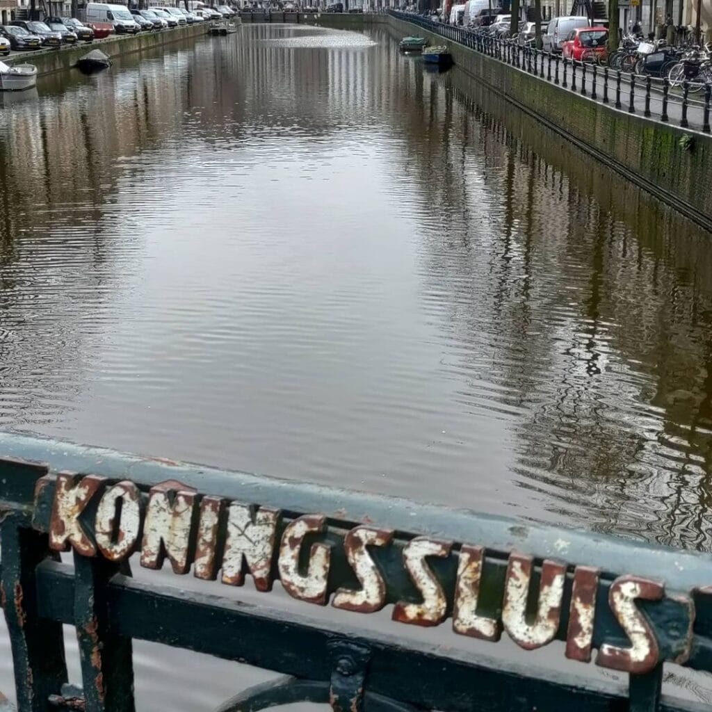
Bridge number 29 (De Koningssluis) brug nummer negenentwintig (King’s Lock)
Piet Kramer adapted designs for this bridge when it was rebuilt on old foundations in the 1920’s and they are known as “from the desk of”. Kramer as we have seen before on Brug 23 designed in the style of the Amsterdam School with the interaction between brick and natural stone and the wrought iron balustrades. The natural stone carving on the sides, with a mythical animal on the four corners, was designed in 1916 by Hildo Krop (February 26, 1884 – August 20, 1970) who was a prolific Dutch sculptor famous for a number of war memorials around the country and city sculptures in the Amsterdam style. Piet Kramer adapted designs for this bridge when it was rebuilt on old foundations in the 1920’s and they are known as “from the desk of”. Kramer as we have seen before on Brug 23 designed in the style of the Amsterdam School with the interaction between brick and natural stone and the wrought iron balustrades. The natural stone carving on the sides, with a mythical animal on the four corners, was designed in 1916 by Hildo Krop (February 26, 1884 – August 20, 1970) who was a prolific Dutch sculptor famous for a number of war memorials around the country and city sculptures in the Amsterdam style. Piet Kramer adapted designs for this bridge when it was rebuilt on old foundations in the 1920’s and they are known as “from the desk of”. Kramer as we have seen before on Brug 23 designed in the style of the Amsterdam School with the interaction between brick and natural stone and the wrought iron balustrades. The natural stone carving on the sides, with a mythical animal on the four corners, was designed in 1916 by Hildo Krop (February 26, 1884 – August 20, 1970) who was a prolific Dutch sculptor famous for a number of war memorials around the country and city sculptures in the Amsterdam style.


An Amsterdam School Masterpiece on the Herengracht at the Koningsplein
Not every bridge in Amsterdam can trace its name to a king. Bridge 29, the Koningssluis, carries that distinction, and it carries it through a remarkable chain of diplomatic courtesy, cartographic accident, and civic memory that stretches from the early years of the Dutch Republic to the present day. The bridge it produced, however, is not a monument to royal grandeur in the traditional sense. It is something more interesting than that: a product of a world war, a doubled budget, the creative tension between two of the Amsterdam School’s greatest designers, and a city sculptor working five years before his designs were finally cast in stone.
1. Etymology and Naming: A King, a Canal, and a Square That Kept His Name
This fixed bridge takes its name from the Koningsplein. In the early years of the 17th century, a section of the Singel was temporarily named Koningsgracht, as a tribute to ally King Henry IV of France. The square on this Koningsgracht therefore acquired the name Koningsplein. The name Koningsgracht did not survive, unlike the names of the square and the bridge.
The layers of this etymology reward unpacking. In the 17th century, the Singel was temporarily renamed Koningsgracht as a mark of honour to King Henry IV of France, who was at that time an important ally of the Dutch Republic. When the name was changed back to Singel not long after, the Koningsplein retained its name. King Henry IV of France, one of the most consequential monarchs of early modern Europe, the man who issued the Edict of Nantes guaranteeing religious tolerance and who forged the diplomatic alliance that helped the young Dutch Republic survive its wars against Spain, was honoured with a canal name that did not outlast his own reign. He was assassinated in 1610. The name Koningsgracht quietly faded. But the square kept the royal association, and the bridge that connects the square to the Leidsestraat has carried the royal name ever since.
The Koningsplein came into being in 1663 when the Heiligewegburgwal, the water running alongside the Heiligeweg, was filled in. The square is not a grand formal space in the Baroque tradition. It is in fact not a true square but a widening of the street in the extension of the Leidsestraat, located between the Herengracht at the Leidsestraat and the Singel at the Heiligeweg. Bridge 29 is the connection between the Koningsplein proper and the Leidsestraat on the other side of the Herengracht, making it less a ceremonial gateway than a busy pedestrian and cycling crossing in the daily flow of a very active part of the inner city.
As with several of the Herengracht bridges encountered earlier in this series, the word “sluis” in the bridge’s name means stenen brug, a stone bridge, rather than a hydraulic lock.
2. Structural Evolution: A 1752 Collapse, an 1875 Rebuilding, a 1903 Reinforcement, and a 1921 Transformation
The structural biography of Bridge 29 is one of the richest of any crossing in this series, documented across multiple centuries with unusual precision.
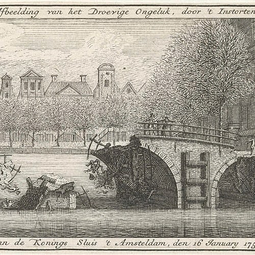
A predecessor of the current bridge, the Koningsbrug, collapsed in 1752. This is a vivid and sobering fact. The Rijksmuseum holds an anonymous engraving from 1752, captioned “Collapsed Koningssluis in Amsterdam,” which documents the event. A bridge on one of the most prominent crossings of the Herengracht simply fell into the canal, a reminder that even the best-maintained urban infrastructure of the Golden Age had finite lifespans.
What followed was a sequence of increasingly ambitious interventions across the next century and a half. In 1875, a stone arched bridge (wulfbrug) was replaced by a lower and flatter version. That bridge was reinforced in 1903 to carry the electric tram. In 1907, the bridge was significantly widened on its southeastern side, almost doubling its previous width.
The modern story of the bridge, however, begins with a municipal decision taken in 1916. The modern history of the bridge begins in 1916, when the municipality decided that the Leidsestraat, and not a possibly filled-in Leidsegracht, would become the main traffic artery to the southwest of Amsterdam. Budget of 140,000 guilders was released for the widening of three bridges in the Leidsestraat, to designs by Jo van der Mey. The price increase for raw materials as a result of the First World War then threw a spanner in the works.
The delay was significant. Due to material shortages caused by the war, the work was postponed. When the municipality doubled the budget in 1920, work on the bridges finally became possible. Work began in 1921 and the bridges were completed in 1922. The widening of the Koningssluis to approximately 23 metres was specifically intended to improve safety for tram passengers boarding and alighting, following a model that had already been successfully implemented on the Utrechtsestraat bridges.
One particularly telling detail from the Amsterdam op de kaart archive: the wrought iron railings were awarded to a German firm, which could supply them considerably more cheaply than Amsterdam smiths. This was a decision that drew comment at the time, given that the First World War had ended only three years earlier.
3. Architectural Lineage: Van der Mey’s Commission, Kramer’s Execution, and Krop’s Creatures
The Koningssluis is, architecturally, one of the most precisely documented bridges in this series, and its design story is also one of the most layered, involving three of the defining figures of the Amsterdam School in a single commission.
The official Rijksmonumentenregister entry is the most authoritative source on what the bridge is and who made it. The Koningssluis is a fixed plate or girder bridge with three navigation openings, completed in 1921 as the result of a rebuilding, designed in the Amsterdam School style by P.L. Kramer for the bridges division of the then Dienst der Publieke Werken of the municipality of Amsterdam. The sculptural work was designed as early as 1916 by Hildo Krop and executed by the firm Johan Polet. The abutments and piers are in brick and natural stone. The wings are in brick in a horizontally stepped form, with a masonry motif incorporated within them, and at the base near the waterline with blocks of natural stone, capped with sculpted natural stone cover plates. The piers in elevation are in a vertically stepped form transitioning into cantilevers of natural stone.
The Dutch Wikipedia article on the Koningssluis provides the critical clarification of the three-way creative relationship: Piet Kramer, the new bridge architect at the time, adapted the designs of his teacher Van der Mey, as he did also for Bridge 43 and the Aalmoezeniersbrug. These bridges are recorded as “from the office of.” Kramer’s hand is evident in the Amsterdam School style with the interplay between brick and natural stone and the ornamental wrought iron balustrades. The natural stone sculptural work on the sides, with a mythical creature on each of the four corners, was designed in 1916 by Hildo Krop. The cantilevers in the bridge piers, however, are by Van der Mey.
This division of authorship is precise and important. Van der Mey conceived the original design and provided the structural piers with their distinctive cantilever profile. Kramer adapted and refined the design into the Amsterdam School vocabulary he had developed, adding the brick and natural stone interplay and the custom ironwork that characterise his bridges across the city. Krop supplied the four mythical creatures at the corners, whose designs preceded the bridge itself by five years. These four mythical creatures by Hildo Krop from 1916 are also found on bridges 43 and 68. The same carved figures therefore appear at three separate locations across Amsterdam, a form of sculptural repetition that was economical in cost but rich in coherence, giving Kramer’s bridges a shared visual language across different parts of the city.
The Grachtenmuseum specifically identifies this bridge as a defining example of the Amsterdam School in bridge design: “From the start of the 20th century onwards, the work of the Amsterdamse School started to become popular. This style is evident in the design of the Koningssluis, between the Koningsplein and the Leidsestraat, by P.L. Kramer. This bridge has become a Rijksmonument, just like many other bridges in Amsterdam.”
4. Urban and Social Context: The Leidsestraat, the Bloemenmarkt, and a Very Busy Crossing
The bridge connects the Koningsplein with the Leidsestraat, spanning the Herengracht. It is less than 50 metres from the Heiligewegsluis over the Singel. This compressed geography places Bridge 29 at one of the most commercially active nodes in Amsterdam’s inner city.
The Leidsestraat itself is a narrow, tram-free shopping street connecting the Koningsplein to the Leidseplein. It is one of the very few streets in the Amsterdam centre that carries its historic name without interruption from canal ring to ring. The decision taken in 1916 to make the Leidsestraat the main southwestern artery for the city’s growing traffic was the direct cause of the bridge’s 1921 transformation, and the widened deck of the Koningssluis is a physical record of that ambition. The municipality later decided that the Leidsestraat was no longer needed for traffic heading out of the city, for which the much wider Rozengracht and Vijzelstraat were more suitable. The arterial ambition was quietly abandoned, but the wide bridge built to serve it remains.
Immediately to the east of the bridge, on the Singel side of the Koningsplein, is the Bloemenmarkt. The Bloemenmarkt is the world’s only floating flower market, founded in 1862 and sited on the Singel canal between Muntplein and Koningsplein. The proximity of a bridge named for a French king to a floating flower market on the same square creates an urban texture that is entirely characteristic of this part of Amsterdam: history, commerce, and daily life layered on top of one another without ceremony.
The University of Amsterdam Library on the Singel also looks out over the Koningsplein, and the Bijenkorf flagship store is within a short walk. This is one of the most heavily trafficked pedestrian zones in the city for much of the year, and the wide deck of Bridge 29, designed to handle tram passengers a century ago, now handles the considerably greater volume of cyclists and tourists that define Amsterdam’s contemporary street life.
5. Technical Specifications
Based on confirmed sources, including the official Rijksmonumentenregister entry (monument number 518393), the following can be stated:
- Bridge type: Fixed plate or girder bridge (vaste plaat- of balkbrug), three navigation openings
- Location: Spanning the Herengracht between the Koningsplein and the Leidsestraat, Amsterdam-Centrum
- Canal: Herengracht (UNESCO World Heritage Canal Belt, listed 2010)
- Completed: 1921 (as a result of rebuilding); formally completed with the two companion Leidsestraat bridges in 1922
- Original design: Jo van der Mey (Dienst der Publieke Werken), 1916
- Executed design: Piet Kramer (P.L. Kramer), adapting and refining Van der Mey’s designs; recorded as “from the office of”
- Sculptural work: Hildo Krop (designed 1916, five years before the bridge was built), executed by the firm Johan Polet; four mythical creatures in natural stone at the four corners, the same figures found at bridges 43 and 68
- Materials: Steel and concrete deck; brick and natural stone abutments and piers; horizontally stepped brick wings with natural stone blocks at the waterline; vertically stepped piers with natural stone cantilever projections; ornamental wrought iron balustrades (supplied by a German firm)
- Predecessor history: Earlier bridge collapsed 1752; stone arched bridge replaced by flatter version 1875; reinforced for electric tram 1903; widened 1907; transformed to current form 1921
- Monument status: Rijksmonument (national monument) since 2001, monument number 518393
- Wikidata: Q17291493
- Amsterdam Monumentenstad ID: 10525
- Heritage significance (per RCE): Of general importance due to its architectural-historical value, the aesthetic quality of its design, and its contribution to the appearance of the city
Sources Consulted
- Bruggenvanamsterdam.nl, bridge register entry for Brug 29: www.bruggenvanamsterdam.nl/herengracht_hoek_leidsestraat.htm
- Bridges.cramberts.com, “De Koningssluis, Bridge 29, History and information”: bridges.cramberts.com/2022/04/03/de-koningssluis-bridge-29-history-and-information/
- Wikipedia (nl), “Koningssluis”: nl.wikipedia.org/wiki/Koningssluis
- Amsterdam op de kaart, “Koningssluis, Koningsplein” (Publieke Werken, P.L. Kramer, 1921): amsterdamopdekaart.nl/1850-1940/Koningsplein/Koningssluis
- Rijksmonumentenregister, monument 518393, “Koningssluis”: monumentenregister.cultureelerfgoed.nl/monumenten/518393
- Rijksmonumenten.nl, monument 518393: rijksmonumenten.nl/monument/518393/koningssluis/amsterdam/
- Wikipedia (nl), “Koningsplein (Amsterdam)”: nl.wikipedia.org/wiki/Koningsplein_(Amsterdam)
- Wikidata, “Koningssluis” (Q17291493): wikidata.org/wiki/Q17291493
- Wikimedia Commons, Category: Brug 29, Koningssluis: commons.wikimedia.org/wiki/Category:Brug_29,_Koningssluis
- Wikipedia (en), “Hildo Krop”: en.wikipedia.org/wiki/Hildo_Krop
- Kunstconsult, “Hildo Krop: Sculptors of the Amsterdam School, part 4”: kunstconsult.com/Blog/Hildo-Krop-Sculptors-of-the-Amsterdam-School-part-4
- Grachtenmuseum Amsterdam, “Bridges”: grachten.museum/en/bridges/
- Grande Flânerie, “Amsterdam School Buildings in Amsterdam”: grandeflanerie.com/portfolio/amsterdamschool/3/
Public Domain Images

1. “Amsterdam brug Koningssluis.jpg,” photograph of the bridge Available in the Wikimedia Commons category for the bridge. This image shows the bridge in its current form with the Krop sculptural work visible at the abutments. URL: https://commons.wikimedia.org/wiki/Category:Brug_29,_Koningssluis Attribution: “Wikimedia Commons, Category: Brug 29, Koningssluis. Available under a free licence.”
2. “Collapsed Koningssluis in Amsterdam, 1752,” anonymous engraving, Rijksmuseum This anonymous print from 1752 documents the collapse of the predecessor bridge and is referenced in the bridge’s historical record. Held in the Rijksmuseum collection and available via its open access digital platform. As a work from 1752 it is firmly in the public domain. URL: https://www.rijksmuseum.nl/en/collection (search: Koningssluis 1752) Attribution: “Anonymous, 1752. Rijksmuseum Amsterdam. Public domain.”

3. “Pieter Oosterhuis, Afb 010005000389.jpg,” photograph of the Koningsplein and the earlier bridge, c. 1888 This photograph, held in the Stadsarchief Amsterdam and reproduced in the Wikimedia Commons category for the bridge, shows the Koningsplein looking east toward the Singel and Heiligeweg, with the earlier Koningssluis (Bridge 29) in the foreground over the Herengracht. Available via both the Stadsarchief Beeldbank and Wikimedia Commons. URL: https://commons.wikimedia.org/wiki/File:Pieter_Oosterhuis,_Afb_010005000389.jpg Attribution: “Pieter Oosterhuis, c. 1888. Collectie Stadsarchief Amsterdam, Afb 010005000389. Public domain.”
Map of Brug 29
De Koningssluis
It spans the Herengracht between the Koningsplein and the Leidsestraat. The bridge can already be seen in a projection of the urban expansion. The buildings then stopped (seen from the north) at the Leidsegracht, but a block had already been built between the Singel and the Herengracht. It is less than 50 meters from the Heiligewegsluis across the Singel.
De Koningssluis is a remarkable architectural feat that connects the bustling Koningsplein with the vibrant Leidsestraat, stretching majestically over the picturesque Herengracht. This iconic bridge is an integral part of the urban landscape and a testament to the city’s rich history. Dating back to a time when the city was undergoing significant expansion, the presence of the bridge in early projections attests to its enduring significance. During this era, the northern boundary of the development ceased at the Leidsegracht, with a striking block of buildings already standing between the Singel and the Herengracht. It is worth noting that the Heiligewegsluis, located a mere 50 meters away across the Singel, adds to the charm and historical allure of the area.


Herengracht between the Koningsplein and the Leidsestraat in Amsterdam is a historic and prestigious part of the city. Herengracht is one of the main canals that forms part of the Amsterdam Canal Belt, which is a UNESCO World Heritage site. Here’s what you can expect to find in this area:
- Historic Canal Houses: The Herengracht canal is lined with stunning and well-preserved canal houses, many of which date back to the 17th century. These houses were originally built for wealthy merchants and aristocrats, and their elaborate facades, gabled roofs, and ornate details are a sight to behold. The canal houses along Herengracht are an iconic representation of Amsterdam’s Golden Age architecture.
- Upscale Neighborhood: The area between Koningsplein and Leidsestraat is considered one of the most upscale and prestigious neighborhoods in Amsterdam. It is characterized by its exclusive residential properties, luxury boutiques, high-end restaurants, and boutique hotels. The neighborhood exudes an air of elegance and refinement.
- Cultural Attractions: Within walking distance from Herengracht, you’ll find several cultural attractions and landmarks. The Koninklijk Theater Carré, a famous theater, is located near the eastern end of the Herengracht. The Royal Palace of Amsterdam (Koninklijk Paleis) on Dam Square and the Anne Frank House are also not far from this area.
- Shopping and Dining: The area offers an array of upscale shopping opportunities, with designer boutiques, art galleries, and specialty stores lining the streets. Additionally, the neighborhood boasts a diverse range of dining options, from Michelin-starred restaurants to trendy cafes and traditional Dutch eateries.
- Connectivity: Herengracht is well-connected to other parts of Amsterdam. The area is easily accessible by public transportation, with tram lines running along Leidsestraat and Koningsplein. Biking is also a popular mode of transport in Amsterdam, and you’ll find bike lanes and rental services throughout the city.
- Canal Cruises: Taking a canal cruise along Herengracht is a popular activity for tourists. These boat tours offer a unique perspective of the canal houses, bridges, and other landmarks that grace the waterway. Canal cruises provide a relaxing way to learn about Amsterdam’s history and architecture.
The area of Herengracht between Koningsplein and Leidsestraat embodies the beauty and grandeur of Amsterdam’s canal belt. It’s a place where history, culture, and sophistication converge, inviting visitors to immerse themselves in the timeless charm and allure of this historic city.
De Koningssluis Brug 29 some history
The King’s Lock has been protected as a national monument since 2001. The modern history of the bridge begins in 1916 when the municipality decided that the Leidsestraat, a possibly filled-in Leidsegracht, would become the arterial road to the southwest of Amsterdam. 140,000 guilders were released for three bridges in the Leidsestraat, which were designed by Jo van der Mey. However, the price increase for raw materials as a result of the First World War threw a spanner in the works. Subsequently, the municipality doubled the budget in 1920, and work on the bridge began. The bridge, completed in 1921, was built partially on the foundations of an earlier bridge by the public works service of the municipality of Amsterdam. Notably, a new architect named Piet Kramer adapted the designs concurrently for bridge 43 and the Alms’ bridge, which we will discuss further in due course. Additionally, it is worth mentioning that Hildo Krop contributed to the project by designing the four sculptures depicting mythical creatures.
Photos
The earlier bridge and the Place Royale in 1888 The Koningsplein seen in an easterly direction towards Singel and Heiligeweg, with in the foreground the Koningssluis (bridge 29) over the Herengracht.
Collapsed Koningssluis in Amsterdam, 1752, anonymous, 1752