The Bridge That Doesn’t Line Up, and the Night the Schouwburg Burned in 1772
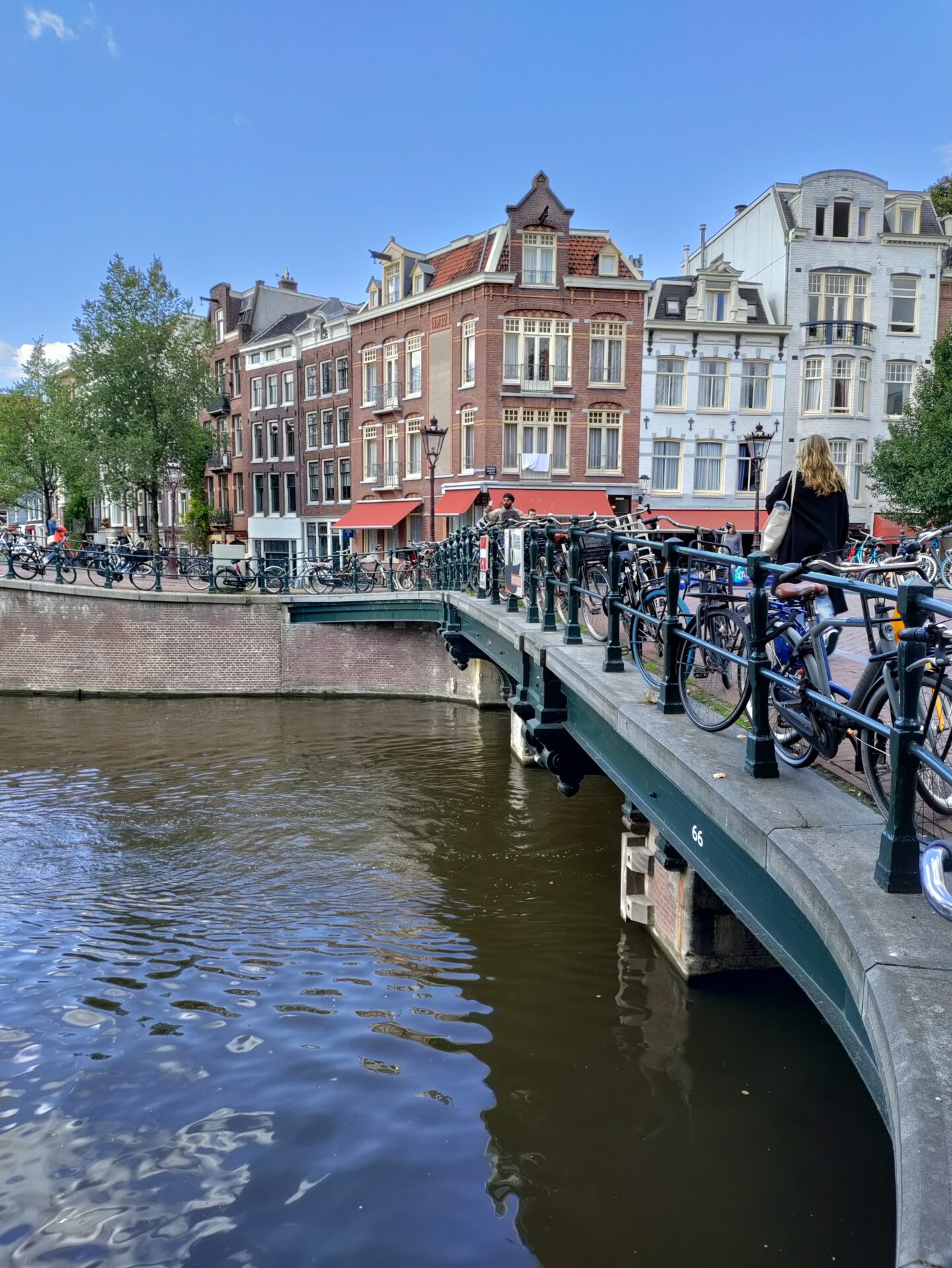
Bridge 66 is a road bridge on the Runstraat, crossing the Prinsengracht. It has a peculiarity that sets it apart from its neighbours to the north: it does not land opposite the street that feeds it. Where the bridges at the Reestraat and the Berenstraat carry a street straight across the water and out the other side, Bridge 66 delivers its traffic onto the northern quay of the Looiersgracht instead. The crossing bends the route rather than continuing it.
The second thing to notice is that the bridge is visibly too big for its own foundations. The piers are plainly not wide enough for the deck plate they now carry, and the mismatch is not a defect but a record: this bridge was widened, and the nineteenth-century supports added to do it are still legible from the water.
Structural Evolution: Berckenrode’s Run Straet, and the Bridge in the Fire Drawings
There has been a crossing here for four centuries. Balthasar Florisz. van Berckenrode drew a bridge at this location on his map of 1625, running over the Prince Graft from the Run Straet to the Loyers Graft — the same slightly awkward alignment the bridge still has today, four hundred years later.
The bridge’s most vivid appearance in the historical record is incidental. It features in a drawing by G. Warnars, Noach van der Meer and P. den Hengst whose actual subject is a disaster: the fire that destroyed the Amsterdamsche Schouwburg on the Keizersgracht on 11 May 1772. The artists chose to depict the blaze as it appeared from the Looierssluis on the Prinsengracht, between nine and ten in the evening — which means this bridge, and the view across the water from it, is the vantage point from which one of eighteenth-century Amsterdam’s great catastrophes was recorded.
The Schouwburg fire killed a number of people and destroyed the city’s principal theatre. That the artists positioned themselves here says something about the bridge’s role in the neighbourhood: it was an obvious place to stand and look east across the canal belt.
The photographer Pieter Oosterhuis later captured the bridge in its arched form, before the changes that produced the flat structure of today.
Architectural Lineage: Lowered, Widened, and Honest About It
The bridge was probably reduced in height at the end of the nineteenth century, to accommodate road traffic once shipping through this stretch had declined. It was lowered and widened in the same period, and the evidence sits in plain sight: the piers carry the characteristic nineteenth-century supports added for the widening, and they remain visibly narrower than the plate above them.
Most rebuilt bridges conceal their history. This one does not. A visitor who looks at the piers from the quay can read the sequence directly — original masonry of one width, later supports bolted to the logic of a wider deck, and a modern plate resting across the whole assembly. It is an unusually candid piece of infrastructure.
The bridge is now a plate bridge. In the early twenty-first century its deck was replaced with dark brick laid between natural stone curbs — the same specification applied to the Reesluis at Bridge 64 in 2014, and part of a consistent municipal approach to surfacing in the protected canal zone.
Urban and Social Context: The Runstraat, the Looiersgracht and the Tanners Again
The Runstraat is one of the Negen Straatjes, and its name belongs to the same industrial vocabulary as its neighbours. Run is tanbark — the ground oak bark used in tanning leather. Set alongside the Reestraat (roe deer), the Berenstraat (bears) and the Looiersgracht (tanners) that this bridge actually lands on, the picture is complete: four consecutive crossings of the Prinsengracht, each named from a different stage or material of the leather trade.
Immediately west stands the Looierssluis, Bridge 103, on the Looiersgracht itself. The cluster of names here is the densest surviving record of the industry that once occupied the southern Jordaan, and it survives entirely in words — the tanneries, the bark stores and the stench are four centuries gone.
Wider Context: Still Just a Number
Amsterdam has more than a thousand bridges, and for most of its history named only a minority of them — by the mid-2010s, roughly a quarter, leaving more than 1,300 unnamed. In July 2016 the city council formally adopted a set of long-used unofficial names and struck out 88 others that were unsubstantiated or liable to confusion. A public call for suggestions followed, drawing some 1,500 proposals, of which around a hundred have been adopted.
Neighbouring bridges have been through the process: Bridge 67 lost the name Kleine Brouwerssluis in 2016 and gained Angenietje Swarthofbrug in 2021. Bridge 66 has not. It is a crossing that appears on the 1625 map, stands where artists sketched the burning of the city’s theatre in 1772, wears its nineteenth-century widening on the outside, and is still called sixty-six.
Technical Specifications
- Bridge number: 66
- Name: None (unnamed)
- Type: Road bridge, plate bridge
- Spans: Prinsengracht
- Carries: Runstraat, landing on the northern quay of the Looiersgracht
- First recorded: Berckenrode map, 1625
- Depicted: In drawings of the Schouwburg fire, 11 May 1772; photographed in arched form by Pieter Oosterhuis
- Lowered and widened: Late nineteenth century, supports visible in the piers
- Deck: Dark brick between natural stone curbs, early twenty-first century
Sources Consulted
- Brug 66, Nederlandstalige Wikipedia
- Balthasar Florisz. van Berckenrode, map of Amsterdam, 1625
- G. Warnars, Noach van der Meer and P. den Hengst, depiction of the Schouwburg fire seen from the Looierssluis, 1772
- Pieter Oosterhuis, photograph of the arched bridge
- Stadsarchief Amsterdam Beeldbank — Prinsengracht en Looiersgracht, c. September 1898
- Gemeente Amsterdam, bridge naming decisions of July 2016
Bridge 66 is a road bridge and is located on the Runstraat and crosses over the Prinsengracht. In contrast to the bridges north of its, this bridge does not connect to a road on the other side of Prinsengracht directly, instead it leads to the northern quay of the Looiersgracht.
As you can see from the pictures this bridge has been previously widened as the piers are clearly not wide enough for the current plate.


.JPG/1200px-Prinsengracht-Runstraat_(brug_66).JPG)
History and information
Balthasar Florisz. from Berckenrode drew a bridge here on his map from 1625, then located over the Prince Graft from Run Straet to Loyers Graft. The bridge is also shown in a drawing by G. Warnars, Noah van der Meer and P. den Hengst, which also capture the fire in the Amsterdamsche Schouwburg, located on the Keizersgracht, but seen from the Looierssluis in the Prinsengracht. That fire occurred on May 11, 1772. The bridge is probably reduced in height at the end 19th century to accommodate road traffic once shipping traffic here decreased. The bridge has external features that were lowered and widened at the end of that century, seen in particular in the piers. It is now a plate bridge and in the early 21st century, the bridge deck was replaced by dark brick, laid between natural stone curbs.


Map and location
Bridge 66 is located on the Runstraat and spans the Prinsengracht. In contrast to the bridges north of its, this bridge does connect to a through traffic route, namely that of the northern quay of the Looiersgracht.
Like most of our previous bridges there has been a bridge here for centuries. Balthasar Florisz. from Berckenrode drew a bridge at this location on his map from 1625, then shown over the Prince Graft from Run Straet to Loyers Graft. Pieter Oosterhuis captured another arch bridge in a picture of the bridge.

