The Last Bridge Over the Keizersgracht, at the Western Bank of the Amstel
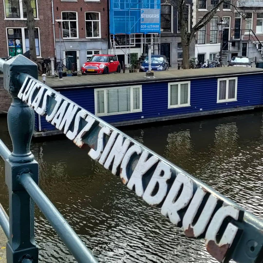
There are bridges in Amsterdam that mark endings. Bridge 36, the Lucas Jansz. Sinckbrug, marks one of the most significant: it is the final crossing of the Keizersgracht, the point where Amsterdam’s widest inner canal finishes its long arc from the Brouwersgracht in the north and flows into the Amstel. Beyond the bridge, the canal ceases to exist under that name. Across the water begins the Nieuwe Keizersgracht, the extension into the later city. The Lucas Jansz. Sinckbrug is therefore, in a structural and geographical sense, a full stop at the end of one of the defining sentences of the Dutch Golden Age. It is also, at 256 years old in its current primary form, one of the oldest structures in this series, and the name it carries belongs to the man who did more than almost anyone to make the canal it spans possible.Bridge number 36 The Lucas Jansz Sinck bridge (De Lucas Jansz Sinckbrug) brug nummer zesendertig
Whilst this bridge is also located on the west bank of the Amstel unlike De Hendrick Jacobsz. Staetsbrug (brug 35) this one spans the Keizersgracht, and just like bridge 35 it is the last bridge of the canal. The numbers will now ascend along the Keizersgracht the opposite direction.
Also like brug 35 this bridge is named after a prominent city developer. Lucas Jansz Sinck who was a renowned Amsterdam surveyor and cartographer. Sinck, who lived on the Rozengracht was known for his maps of the Beemsterpolder, as well as for his work for the third expansion of the Amsterdam canal belt. We’ve seen his maps already on some other bridges and no surprise there will be one of his maps in the next map post and some more about the city expansions in the post following that.


1. Etymology and Naming: The Surveyor Who Laid Out the Grachtengordel
The bridge is named after Lucas Jansz. Sinck. He was the city surveyor who, together with Hendrik Staets, Frans Oetgens, and Hendrick de Keyser, prepared and partly executed the Uitleg (Expansion) of 1612 and thereby laid the foundation of the Amsterdam canal belt.
Peter Korrel is the person who proposed this bridge name. As with the Isa van Eeghenbrug (Bridge 30), the naming was driven by Korrel’s meticulous work documenting Amsterdam’s bridge heritage, and it gives the bridge a commemorative weight appropriate to its geographical position at the terminus of the Keizersgracht.
Lucas Jansz. Sinck was a renowned Amsterdam surveyor and cartographer. He lived on the Rozengracht and became known for his maps of the Beemster polder, as well as for his work on the Third Expansion of the Amsterdam canal belt. He was buried in Amsterdam on 10 November 1622. The date of his death tells its own story: Sinck was buried in 1622, meaning he lived to see the canal belt he helped design taking shape, but did not survive to see the full southern extension completed in the 1660s. His name lives on in the bridge at the southern end of the canal he helped to plan.
The trio of bridges at this stretch of the Amstel form a deliberate commemorative set. The bridge is named after the surveyor Lucas Jansz. Sinck, who together with Hendrick Jacobsz. Staets, Frans Oetgens, and Hendrick de Keyser was responsible for preparing and executing the Third Expansion of the canal belt. They each received bridges named after them: Staets over the Herengracht, Lucas Jansz. Sinck over the Keizersgracht, and others over the Prinsengracht and Achtergracht, all at the point of their intersection with the Amstel. The row of eponymous bridges along the Amstel’s western quay is therefore a kind of civic memorial in stone and arch, honouring the team that gave Amsterdam its defining urban form.
The contribution of Sinck to the canal belt’s practical realisation cannot be overstated. The first part of the Keizersgracht, between Brouwersgracht and approximately the current Leidsegracht, was dug in the summer of 1615 at the initiative of mayor Frans Hendricksz. Oetgens, city carpenter Hendrick Jacobsz. Staets, and city surveyor Lucas Jansz. Sinck. The Herengracht was built starting in 1612 on the initiative of Mayor Frans Hendricksz. Oetgens, city carpenter Hendrick Jacobsz. Staets, and city surveyor Lucas Jansz. Sinck. Construction of the Prinsengracht started in 1612 on the initiative of Mayor Frans Hendricksz. Oetgens, after a design by city carpenter Hendrick Jacobsz. Staets and city surveyor Lucas Jansz. Sinck. Sinck’s name appears on the founding documents of all three great canals. Bridge 36, at the southern terminus of the middle one, is his permanent monument in the city fabric.
2. Structural Evolution: Five Openings in 1679, Built in Its Current Form in 1769, Renewed in 1977
The documentary and physical record for Bridge 36 is among the most precisely dated in this series, anchored by a stone inscription that has been set into the bridge fabric since the 18th century.
There has been a bridge here for centuries. Daniël Stalpaert, city architect, drew a bridge in his plan of 1662, but buildings are still entirely absent at that point; it is more a street plan than a true map. Jacob Bosch and Frederik de Wit also drew the bridge on their maps of 1679 (showing five navigation openings) and 1688, over the Keijsers Graft.
The Jacob Bosch map of 1679, which shows five openings, is a striking detail. A five-opening bridge in 1679 would have been a substantial structure by the standards of the time, designed to handle the volume of boat traffic entering and leaving the Keizersgracht from the Amstel. The five openings confirm that this was always treated as a significant gateway, not merely a local pedestrian crossing.
The date of the current primary structure is confirmed not by a document but by physical evidence in the bridge itself. The current bridge dates from 1769, as attested by a stone set into the northern quay wall on the Amstel side. That makes Bridge 36 the oldest bridge in this series in its primary form, predating the Vier Heemskinderenbrug (probable 1722 construction date, though the Anno stone records 1734) and contemporary with the generation of 18th-century arch bridges that still define the character of the canal belt’s southern reaches.
The modern structural history records one decisive intervention. The bridge had to be regularly adapted to the demands of modern traffic, particularly due to the increasing weight and axle pressure of vehicles. In 1977 it underwent a thorough overhaul, with renewal of the foundations and arch construction. This 1977 renewal is the same category of mid-to-late 20th-century structural reinforcement documented at Bridge 31 (Tante Saarbrug) in 1968 and 1981: a working 18th-century arch bridge brought up to the load-bearing standards required by 20th-century traffic without changing its outward appearance. The 1769 date stone in the quay wall therefore records the primary construction, while the 1977 overhaul records the renewal of everything beneath and within it.
3. Architectural Lineage: A Three-Arch Stone Bridge, Pre-Amsterdam School, Surrounded by Monuments
The stone arch bridge has three spans. This is the defining structural fact of Bridge 36, and it places it in the same family as the Vier Heemskinderenbrug (Bridge 28) and the Tante Saarbrug (Bridge 31): genuine 18th-century arch bridges that have survived the modernisation drive of the late 19th and early 20th centuries without being flattened or replaced.
No individual architect is confirmed for Bridge 36 in any source consulted for this post. It belongs to the Dienst der Publieke Werken’s 18th-century bridge-building tradition, the same anonymous civic craftsmanship that produced the arch bridges over the Reguliersgracht. The brick abutments, the natural stone arch elements, and the three-span profile are characteristic of that tradition.
The bridge’s relationship to the Amsterdam School movement is straightforward: it predates the movement by approximately 140 years and was never in the queue for replacement by a Kramer or Van der Mey design, partly because its three-arch stone form was already deeply embedded in the landscape of the Amstel waterfront, and partly because the widening pressure that drove so many canal belt bridges to be rebuilt in the late 19th century was less intense here than on the main shopping and tram streets.
Bridge 36, a municipal monument since 1995, is surrounded by municipal and national monuments. The Amstel waterfront at this point is one of the most concentrated protected heritage zones in Amsterdam: canal houses facing the river on both sides, the Magere Brug visible a short distance upstream, and the Nieuwe Keizersgracht beginning directly across the water.
Of the fourteen bridges that span the Keizersgracht, the Lucas Jansz. Sinckbrug at the junction with the River Amstel is the oldest and most picturesque.
4. Urban and Social Context: The End of the Keizersgracht, the Amstel, and a View Across to the Nieuwe Keizersgracht
Bridge 36 is located on the western quay of the Amstel and spans the Keizersgracht. This makes it the last bridge over the Keizersgracht, which ends here. The bridge sits at a point where the character of the city changes perceptibly. The Keizersgracht behind it is the canal ring at its most refined: tree-lined, flanked by protected canal houses, traversed by tourist boats and cycling Amsterdammers. Ahead, the Amstel opens out into a much wider waterway, with a completely different spatial quality. The Magere Brug (Bridge 29 of the Amstel crossing system, though not to be confused with Bridge 29 of the general bridge numbering system visited earlier in this series as the Koningssluis) is visible to the south. The Nieuwe Keizersgracht begins directly across the river.
Across the Amstel, the Nieuwe Keizersgracht was dug as an extension, and it too begins with a bridge, the Dirk van Nimwegenbrug (Bridge 241). The two bridges face each other across the Amstel, one the terminus of the old canal and one the start of its continuation, a geographical dialogue preserved in two separate bridge numbers.
The Stadsarchief Amsterdam Beeldbank holds a photograph attributed to Jacob Olie, captioned precisely: “De Amstel gezien in zuidoostelijke richting over de Lucas Jansz. Sinckbrug (Brug 36) naar Keizersgracht 826. Rechts op de hoek Keizersgracht 767.” This photograph, showing the view southeast across the bridge toward the far side of the Amstel, is one of the most direct archival records of the bridge’s position and its relationship to the Amstel waterfront. Olie (1834 to 1905) was one of Amsterdam’s most important early photographers, and his images of the canal belt in the late 19th century are among the most valuable primary visual sources for the history of Amsterdam’s bridges and waterways.
The Museum Van Loon at Keizersgracht 672, a preserved 17th-century canal house with an intact period interior and celebrated garden, is a short walk along the Keizersgracht from the bridge. From the Museum Van Loon, it is only a brief walk to the Lucas Jansz. Sinckbrug that marks the end of the canal. The Magere Brug is a two-minute walk along the Amstel. The Hermitage Amsterdam (now Amstel 51, having been repurposed after the Hermitage’s departure) is almost directly opposite on the far bank.
5. Technical Specifications
Based on confirmed sources, the following can be stated:
- Bridge type: Fixed three-span stone arch bridge (vaste stenen welfbrug met drie overspanningen)
- Location: Western quay of the Amstel, spanning the mouth of the Keizersgracht, Amsterdam-Centrum
- Canal crossed: Keizersgracht (dug from 1615, named after Holy Roman Emperor Maximilian I, the widest canal in the Amsterdam city centre at 28.31 metres; the Lucas Jansz. Sinckbrug is its final, southernmost bridge)
- Cartographic record: Daniël Stalpaert city plan, 1662 (planned, no buildings yet present); Jacob Bosch map, 1679 (five navigation openings); Frederik de Wit map, 1688 (completed bridge in developed area)
- Construction date: 1769, confirmed by a datestone set into the northern quay wall on the Amstel side
- Major renovation: 1977 (foundation and arch construction renewed)
- Designer: Dienst der Publieke Werken (18th-century tradition); no individual architect confirmed
- Amsterdam School attribution: None; the bridge predates the movement by approximately 140 years
- Relationship to Bridge 35: Directly adjacent on the Amstel’s western quay; Bridge 35 (Hendrick Jacobsz. Staetsbrug) spans the Herengracht; Bridge 36 spans the Keizersgracht; together they form the southern termini of two of the three great concentric canals, both named after members of the 1612 canal belt design team
- Facing bridge: Dirk van Nimwegenbrug (Bridge 241), at the start of the Nieuwe Keizersgracht, directly across the Amstel
- Monument status: Gemeentelijk monument (municipal monument) since 1995
- Named by: Peter Korrel (bruggenvanamsterdam.nl)
- Wikidata: Q23668125
Sources Consulted
- Bruggenvanamsterdam.nl, bridge register entry for Brug 36: www.bruggenvanamsterdam.nl/keizersgracht_hoek_amstel.htm
- Wikipedia (nl), “Lucas Jansz. Sinckbrug”: nl.wikipedia.org/wiki/Lucas_Jansz_Sinckbrug
- Bridges.cramberts.com, “De Lucas Jansz. Sinckbrug, Bridge 36, Amsterdam”: bridges.cramberts.com/2022/04/03/de-lucas-jansz-sinckbrug-bridge-36-amsterdam/
- Bridges.cramberts.com, “De Lucas Jansz. Sinckbrug, Bridge 36, Map and location”: bridges.cramberts.com/2022/04/03/de-lucas-jansz-sinckbrug-bridge-36-map-and-location/
- Wikipedia (nl), “Lucas Jansz. Sinck”: nl.wikipedia.org/wiki/Lucas_Jansz_Sinck
- Wikipedia (en), “Keizersgracht”: en.wikipedia.org/wiki/Keizersgracht
- Wikipedia (en), “Herengracht”: en.wikipedia.org/wiki/Herengracht
- Wikipedia (en), “Prinsengracht”: en.wikipedia.org/wiki/Prinsengracht
- Peoplepill.com, “Lucas Jansz. Sinck: Cartograaf”: peoplepill.com/people/lucas-jansz-sinck
- Hotels.com Go Guides, “Keizersgracht in Amsterdam”: hotels.com/go/netherlands/keizersgracht-amsterdam
- Stadsarchief Amsterdam Beeldbank, “De Amstel gezien in zuidoostelijke richting over de Lucas Jansz. Sinckbrug (Brug 36) naar Keizersgracht 826,” Jacob Olie photograph: archief.amsterdam/beeldbank/detail/e825dcfb-48c5-3ea6-98b8-28ed30d7ca41
- Wikimedia Commons, Category: Brug 36, Lucas Jansz. Sinckbrug: commons.wikimedia.org/wiki/Category:Brug_36,_Lucas_Jansz_Sinckbrug
- Frank V. Smit, “Bruggen in Amsterdam,” 2008, Uitgeverij Matrijs (cited in Wikipedia nl, “Lucas Jansz. Sinckbrug”)
Public Domain Images

1. Jacob Olie photograph, “De Amstel gezien in zuidoostelijke richting over de Lucas Jansz. Sinckbrug (Brug 36) naar Keizersgracht 826,” Stadsarchief Amsterdam This photograph, captioned “De Amstel gezien in zuidoostelijke richting over de Lucas Jansz. Sinckbrug (Brug 36) naar Keizersgracht 826,” is held in the Stadsarchief Amsterdam Beeldbank. Jacob Olie (1834 to 1905) is in the public domain. This is also referenced in the Wikimedia Commons category for the bridge as “Amstel 232 (rechts) Jacob Olie (max res).jpg,” available at 7,032 by 5,655 pixels, one of the highest-resolution historical images of any bridge in this series. URL: https://archief.amsterdam/beeldbank/detail/e825dcfb-48c5-3ea6-98b8-28ed30d7ca41 Attribution: “Jacob Olie, c. 1890 to 1905. Collectie Stadsarchief Amsterdam. Public domain.”

2. Wikimedia Commons category photographs, Brug 36 The Wikimedia Commons category for Bridge 36 holds eight images including contemporary photographs of the three-span arch structure from both the Keizersgracht and Amstel sides, as well as the Jacob Olie historical photograph. URL: https://commons.wikimedia.org/wiki/Category:Brug_36,_Lucas_Jansz_Sinckbrug Attribution: “Wikimedia Commons, Category: Brug 36, Lucas Jansz. Sinckbrug. Available under the licences specified on individual file description pages.”
Map and location of Bridge 36 (De Lucas Jansz Sinckbrug)
This bridge is located also located on the western quay of the Amstel but spans the Keizersgracht the next canal along from Herengracht. This makes it the last bridge over the Keizersgracht, which ends here. Bridge 36 has been a municipal monument since 1995.
There has been a bridge here for centuries. Daniël Stalpaert the city architect drew a bridge in his plan of 1662, but buildings are still missing so it is more of a street plan than a true map. However, Jacob Bosch and Frederick de Wit also drew the bridge on their maps of 1679 and 1688 over the Keijsers Graft.
Pictures
2 Map of the Beemster polder by LJ Sinck from 1612
3 A 17th century map of the Purmer, made by the Amsterdam surveyor Lucas Jansz Sinck
4 De brug op de kaart uit 1679


De Hendrick Jacobsz. Staetsbrug History and Information
Bridge 35 is named after Hendrick Jacobsz. Staets (circa 1558/1559 – circa 1630/1631) who was a city carpenter of Amsterdam and in that capacity one of the main responsible for the design of the canal belt of Amsterdam. Staets worked together with the city master stonemason Hendrick de Keyser and the city master mason Cornelis Danckertsz. the row. As a city master carpenter, he was closely involved in the construction of the Noorderkerk and the Zuiderkerk there.
The current bridge still has two stones on the Amstel side with “Anno” and “1728” on either side of the middle passage. The bridge also played a role in the raising of bridge 34 in the Utrechtsestraat, because skippers found it strange that they could pass under this bridge, but were then stopped by the low bridge 34. The bridge looks old, but is made of inside in 1972 reinforced with reinforced light concrete, the foundations were reinforced in 1977. The bridge has been a municipal monument since 1995. De Hendrick Jacobsz. Staetsbrug History and Information
Bridge 35 is named after Hendrick Jacobsz. Staets (circa 1558/1559 – circa 1630/1631) who was a city carpenter of Amsterdam and in that capacity one of the main responsible for the design of the canal belt of Amsterdam. Staets worked together with the city master stonemason Hendrick de Keyser and the city master mason Cornelis Danckertsz. the row. As a city master carpenter, he was closely involved in the construction of the Noorderkerk and the Zuiderkerk there.
The current bridge still has two stones on the Amstel side with “Anno” and “1728” on either side of the middle passage. The bridge also played a role in the raising of bridge 34 in the Utrechtsestraat, because skippers found it strange that they could pass under this bridge, but were then stopped by the low bridge 34.


In 2017 the bridge was part of Amsterdam Light Festival Editie #6 WHOLE HOLE by Paul Vendel & Sandra de Wolf
Photos Whole Hole