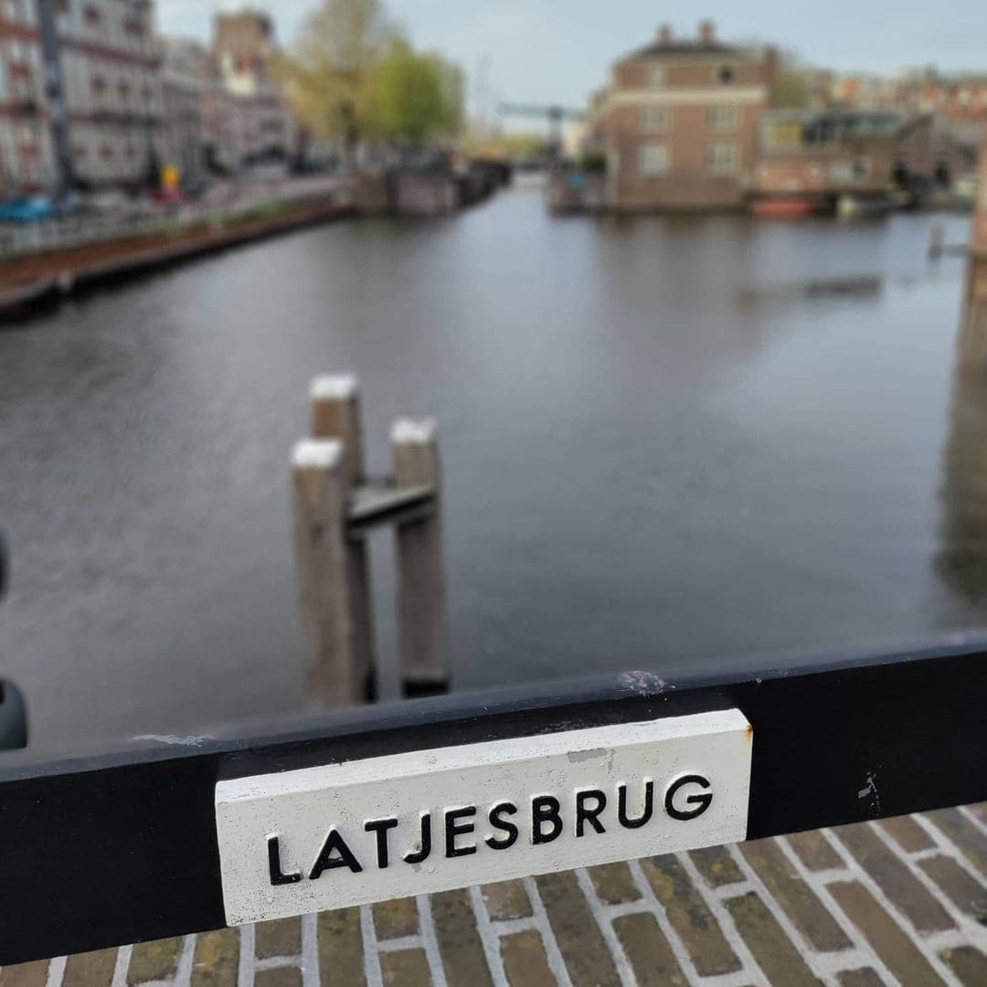
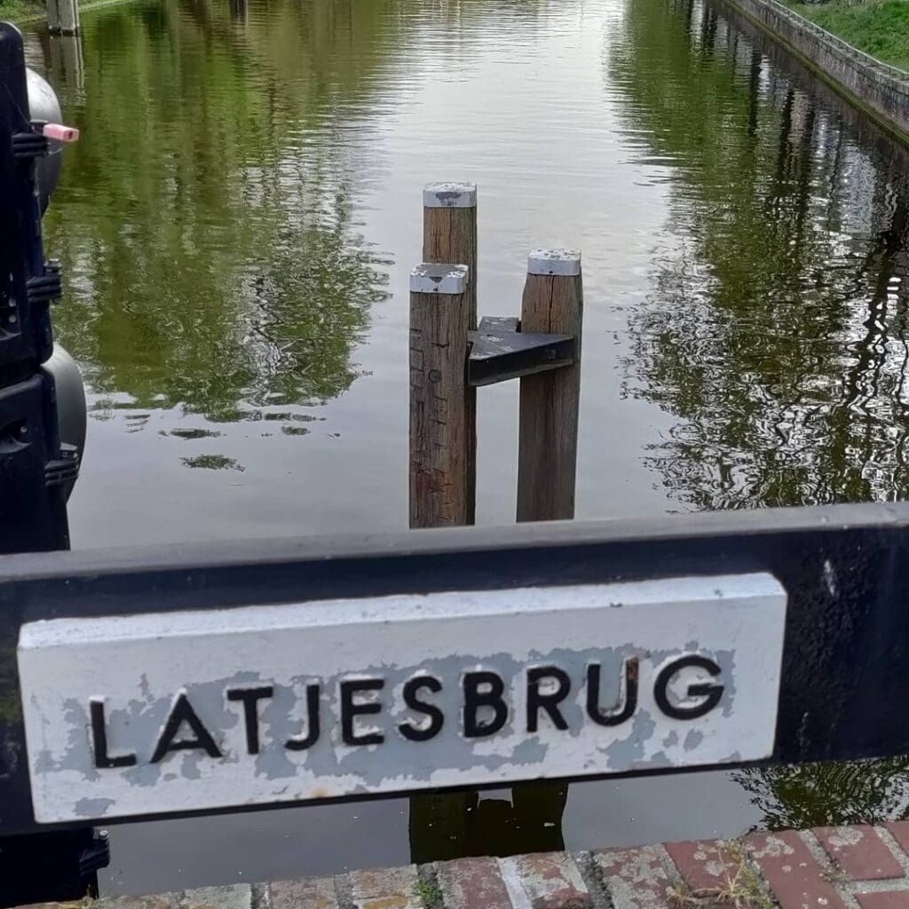
A Name Born of Practicality
Amsterdam’s bridges carry their identities in many ways. Some commemorate merchants, admirals, or city engineers. Others take their names from vanished gates, nearby churches, or trades that once defined their neighborhood. Bridge 50, the Latjesbrug, belongs to a different, altogether more literal tradition: it is named for the material underfoot.
The deck of the predecessor of this bridge was originally made of closely spaced wooden slats (latten), and it was precisely this feature that gave the bridge the nickname Latjesbrug. That predecessor was itself simply repeating a pattern already twice established in Amsterdam’s topography. The first Latjesbrug in the city once led over the Overtoomse Vaart toward the Pesthuis, which also served as an asylum, and from there came the old Amsterdam expression: “Jij moet over de Latjesbrug” (“You need to cross the Latjesbrug”), meaning, in plain terms, that you ought to be committed. A second Latjesbrug once connected the Rozengracht with the windmill known as De Victor. The current bridge on the Nieuwe Herengracht is, then, the third Amsterdam crossing to carry that evocative, slightly comic name, a name that started as a pedestrian description of its wooden surface and outlasted the material itself by a century and more.
The “latten” etymology has nothing to do with a family name, a religious house, or a defunct city gate. It is the city’s no-nonsense side: when Amsterdammers could see what a thing was made of, they simply said so.
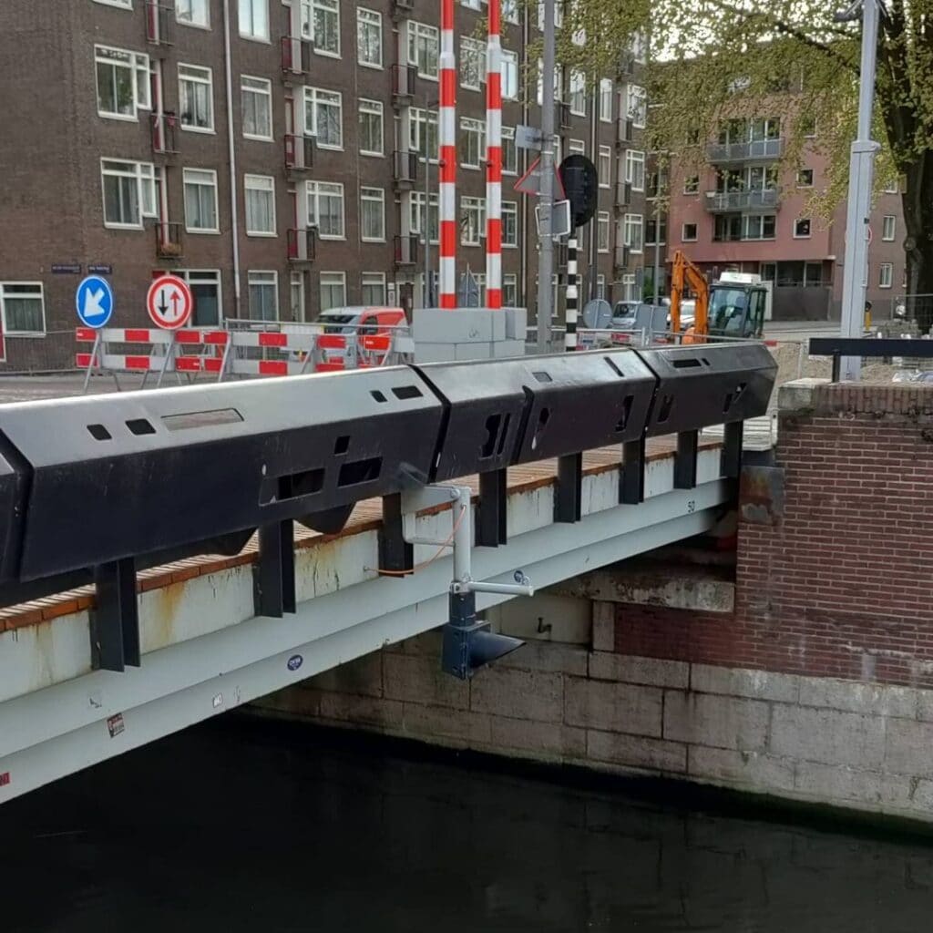
Bridge 50 is not along the Keizersgracht. It’s not even in the same neighbourhood. Located between the botanical gardens and the maritime museum along Nieuwe Herengracht where it flows into the Entrepotdok at Anne Frankstraat it is our first bascule bridge. A bascule bridge (aka drawbridge) has a bridge plate that raises to allow water traffic to pass by below. The counterweight is often hidden below the road surface in the bridge abutment and this is the case for #bridge50.


The Canal, the Quarter, and the First Crossing
To understand the Latjesbrug, you have to understand its water. The Nieuwe Herengracht sits in the Plantage neighborhood, in the eastern part of the Grachtengordel (canal belt). The Herengracht itself, dug in 1612, is named after the “Heren Regeerders” who governed Amsterdam in the 16th and 17th centuries, and the Nieuwe Herengracht represents its final eastward extension, reaching toward the IJ.
A bridge at this specific spot can first be found on a map dating from around 1875. At that time, the area to the southwest of the bridge was still the Plantage, later to become the Diergaarde Plantage and eventually Artis, Amsterdam’s famous zoological garden. On the northwest bank, there was as yet no continuous street: the Anne Frankstraat (the road that now carries the bridge) was not laid out until the late 1960s.
The broader neighborhood, anchored by the Plantage and the Entrepotdok, has long carried the layered character of Amsterdam’s eastern expansion: a mix of modest canal-side dwellings, monumental bonded warehouses, scientific institutions (the Hortus Botanicus sits close by), and, a little downstream, the former Hermitage and what is now the Nationaal Holocaust Naammonument. This was never the fashionable western canal ring. It was a working, commercial, and increasingly cultural quarter, connected to the city’s great warehouse complex by the waters of the Nieuwe Herengracht and the Entrepotdok.
The Nieuwe Herengracht as Jacob Olie Knew It

The Iron Predecessor: Spareness as a Statement (1919-1920)
The bridge that would directly precede today’s structure was scheduled for replacement between June and December 1919, but the municipality did not begin work until half a year later, completing it between December 1919 and March 1920. The Dienst der Publieke Werken (the municipal Public Works Department) delivered an iron drawbridge (ophaalbrug) designed by engineer Wichert Arend de Graaf. At the time, the bridge was praised for its “purity”: it had no decorative embellishments whatsoever.
This absence of ornament is worth pausing on. The Dienst der Publieke Werken was, in those same years, commissioning some of the most exuberantly decorated bridges in Europe. From 1910 onward, the Public Works Department had decided, for aesthetic reasons, to employ a number of young architects whose names would later become synonymous with the Amsterdam School movement, among them Michel de Klerk, Piet Kramer, and Joan van der Meij. These architects created beautiful designs for government buildings, schools, and bridges, and devoted a great deal of attention to street furniture as well.
De Graaf’s 1920 bridge, by contrast, was consciously stripped down. According to bridge historian Smit van Wichert, bridges of the De Graaf type belong to a first generation of drawbridges, very few of which survive because they became outdated and appeared somewhat crude. In the years following their construction, De Graaf’s drawbridges gradually became more ornate, with opening mechanisms that evolved under the influence of structural engineer Adriaan Dwars from 1915 onward. The Latjesbrug’s predecessor, then, was an early, austere specimen of the De Graaf drawbridge family.
The bridge was a sibling to the Westerkeersluis (bridge 346) in the Tasmanstraat over the Westerkanaal, also later removed. And it was precisely the iron bridge with its wooden-slatted deck that fixed the name Latjesbrug to the location permanently.
Turbulence Between the Wars
The bridge’s interwar years were restless ones. In 1931, plans were drawn up to construct a new main road right next to the bridge and to demolish it entirely, but these plans were subsequently cancelled. What followed was a long period of uncertainty tied to the trajectory of the IJ-tunnel and the urban reorganization that came with it, including street redesigns, the filling of canals, and the reshaping of public squares. In 1938, the bridge was briefly taken out of service because it had become corroded and had to be de-rusted.
The neighborhood around it was itself in flux. The vast Entrepotdok warehouses, built in the 1820s as bonded storage for taxable goods, had long since lost their original commercial purpose, and the area’s character was shifting from industrial to residential. The bridge, modest as it was, kept providing the essential east-west connection between the Plantage and the docks.
The IJtunnel and the Decision to Rebuild (1962-1968)
The opening of the IJ-tunnel, Amsterdam’s major road tunnel under the IJ waterway, was the event that finally sealed the old bridge’s fate. As the completion of the IJ-tunnel approached, it became necessary to adapt this bridge as well. For traffic access to and from the north, a breakthrough was forced in the Rapenburgerstraat from 1962 onward, and in the process, house numbers 45-47 on the Rapenburgerstraat and numbers 169-173 on the Nieuwe Herengracht were demolished.
The new bridge would need to be wide enough to absorb significantly heavier traffic. Anticipating this increase, Dirk Sterenberg of the Publieke Werken department designed a bridge 24 meters wide. Sterenberg also designed the cast-iron name plates.
Work began on 12 January 1967, just after the contract was awarded. The expected completion date was autumn 1968, and indeed, by October 1968 the project was finished. The bridge has been barely altered since.
The Latjesbrug Photographed in 1964, Before Demolition

The Architect: Dirk Sterenberg and the Amsterdam School Inheritance
Dirk Sterenberg occupies an intriguing position in the history of Amsterdam’s bridges. He was not one of the founding generation of the Amsterdam School, those expressionist giants of brick and iron who reshaped the city between roughly 1910 and 1940. But he worked consciously within their legacy, and the Latjesbrug offers a textbook illustration of how that inheritance was transmitted.
Sterenberg designed the Latjesbrug in a way that, at the abutments and land anchors (walkanten en landhoofden), evokes the Amsterdam School bridges of Piet Kramer. Other elements that point toward the Kramer tradition include the small terrace-like platforms beside the bridge and the decorated bridge balustrades, which in this case were designed by Herman van der Heide.
Piet Kramer himself, in the second half of his professional life, served as lead architect for canal bridges in the municipal public works department. He drew plans for more than 500 bridges, of which 220 were realized, and alongside the bridges he frequently designed the associated bridge houses, ironwork, and even the surrounding landscape. By the time Sterenberg was working in the 1960s, Kramer had died (in 1961), but his vocabulary of decorated brick abutments, graceful ironwork balustrades, and integrated “terrasjes” beside bridge openings had become a kind of house style that the Publieke Werken continued to honor.
The result at bridge 50 is a structure that feels simultaneously modern (in its scale and its reinforced concrete engineering) and rooted in the city’s 20th-century architectural tradition. The Latjesbrug is, as the Dutch Wikipedia description puts it, a massive steel presence on the waterway, comparable in scale to the nearby M.S. Vaz Diasbrug (a little further along the Nieuwe Herengracht), and acknowledged by its own designers to be frankly too large for the actual traffic volumes it now carries.
Technical Specifications
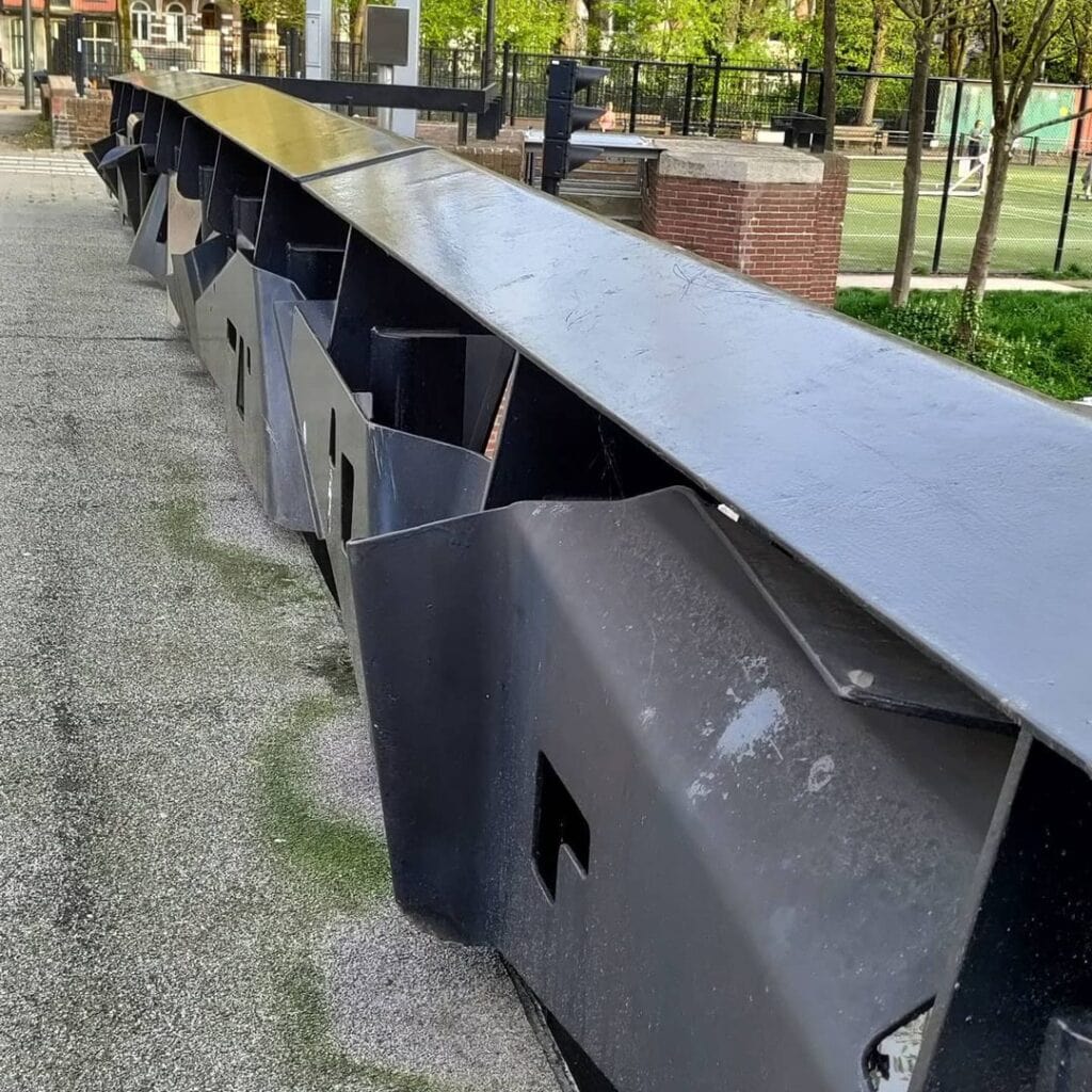
Type: Bascule bridge (basculebrug). This is a moveable bridge in which a counterweighted leaf or pair of leaves pivots upward to allow shipping to pass underneath, as opposed to the earlier ophaalbrug (drawbridge) it replaced. It is located in the Anne Frankstraat and crosses the Nieuwe Herengracht at the corner of the Entrepotdok.
Width: 24 meters, designed by Dirk Sterenberg, Dienst der Publieke Werken, Amsterdam.
Balustrades: Wrought iron decorative railings by Herman van der Heide, referencing the Amsterdam School tradition.
Name plates: Cast iron (gietijzeren naambordjes), also designed by Sterenberg.
Completion: October 1968.
Bridge number: 50 (brug 50 in the municipal numbering system maintained in the Basisregistratie Adressen en Gebouwen, BAG).
The bridge carries no tram line and is not a “plein” (public square) bridge in the manner of some larger Amsterdam crossing points. It functions primarily as a road and cycling bridge, serving the residential and tourist traffic moving between the Plantage district, the Hortus Botanicus, and the waterfront. Monitoring data shows the Latjesbrug opens on average most frequently on Thursdays, and between 11 and 12 in the morning is the busiest period for shipping, causing brief diversions for road users.
Neighbourhood, Landmarks, and Urban Life
The Latjesbrug sits at a genuinely rich intersection of Amsterdam’s history. Standing on its deck, a visitor can orient themselves toward several major landmarks almost simultaneously. To the southwest, along the Nieuwe Herengracht, lies the Wertheimpark, Amsterdam’s oldest public park (1898), with the somber Auschwitz Nooit Meer monument at its heart. To the northwest, the concentration of rijksmonumenten (nationally protected buildings) along the canal quays offers an almost unbroken row of 17th and 18th-century canal houses, many of which once belonged to the prosperous Jewish community that made the Plantage neighborhood its home. On the northwest side, a number of these national monuments face the bridge directly.
A short walk eastward brings you to the Entrepotdok, the early 19th-century bonded warehouse complex, now converted into apartments, and one of the finest examples of industrial heritage in the Dutch capital. Nearby are Artis Royal Zoo and the Hortus Botanicus, both institutions that root themselves in the Plantage’s 19th-century identity as a place of scientific leisure for Amsterdam’s upper-middle classes.
The Latjesbrug is not, in the classic tourist sense, a “famous” bridge. It lacks the intimate, photographer-friendly charm of the smaller arched bridges in the Jordaan or the Nine Streets. Its scale is industrial, its geometry is boxy, and its materials are primarily steel and concrete. But precisely for that reason it has a certain honest grandeur. It is a working bridge, a real participant in the movement of the city, opening for barges and closing for cyclists, day after day, in a neighborhood where the layers of Amsterdam history, from Golden Age canal houses to the shadow of the Shoah to the vibrant life of contemporary Plantage, press close from every direction.
The Nieuwe Herengracht and Wertheimpark Today

A Name That Outlasted the Slats
The story of the Latjesbrug is, in miniature, the story of how Amsterdam maintains its own memory. The wooden slats that gave the bridge its name are gone, replaced first by iron, then by concrete and steel. The narrow 19th-century crossing has been swallowed up by a 24-meter behemoth of the late 1960s. The street that now approaches it from the northwest, the Anne Frankstraat, did not exist when the bridge first appeared on maps. And yet the name holds.
“Jij moet over de Latjesbrug,” Amsterdammers used to say, meaning you need your head examined. The name once carried a whole geography of stigma, pointing toward the asylum on the other side of another bridge entirely. For bridge 50 on the Nieuwe Herengracht, the name carries no such shadow. It is simply a reminder that this city, for all its grand canal-ring ambitions, has always had a practical streak: if the deck is made of slats, that is what you call the thing, and you go on calling it that long after the slats have vanished into history.
Primary references: Frank V. Smit, “Bruggen in Amsterdam” (2008, Uitgeverij Matrijs); Stadsarchief Amsterdam beeldbank, accession numbers 37d3535c and 89c3182b; Dutch Wikipedia, “Latjesbrug” (consulted April 2026); Ensie: XYZ van Amsterdam, “Latjesbrug”; Erfgoedregister Amsterdam, entry c5900d87; BAG (Basisregistratie Adressen en Gebouwen), municipality of Amsterdam.
Latjesbrug (bridge 50) map and location
This bascule bridge is located in Anne Frankstraat and crosses Nieuwe Herengracht at the corner of Entrepotdok. A bridge can be found on a map from around 1875. Southwest of the bridge is the Plantage, which would later be converted into Diergaarde Plantage, later Artis (the Zoo). Also to the southwest is the Wertheim Park as well as Hortus (the botanical gardens).


Bridge 50 history and information
The old iron bridge had wooden slats as a road surface, which gives the bridge the nickname Latjesbrug.
It had previous names though Pestbrug (plague bridge) and Gasthuisbrug (Guest House bridge) originating from the former Pesthuis, later the Buitengasthuis, which was located here.
The previous iron drawbridge was a design by Wichert Arend de Graafop, which at the time was praised for its plainness. It was a sister of the Westerkeersluis (bridge 346) in the Tasmanstraat over the Westerkanaal (also removed later). After the tug of war about the route of the IJtunnel began with all its consequences, such as the redevelopment of streets, squares, and the filling of canals. The bridge was out of service in 1938 due to rust. As the delivery of the IJtunnel approached it was necessary to adapt this bridge as well. From 1962 onwards, a breakthrough was forced for traffic to and from the north in the Rapenburgstraat in the expectation that the amount of traffic would increase, Dirk Sterenberg designed a bridge with a width of 24 meters. The demolition work began on January 12, 1967. Sterenberg designed a bridge that reminds us of Piet Kramer’s Amsterdam School Bridges with the quayside and abutments. Other similar elements are the terraces next to the bridge and decorated bridge balustrades designed by Herman van der Heide. For the surrounding area, it became a huge steel colossus, resembling the MS Vaz Dias bridge a little further on. The project was completed in October 1968 and the bridge has hardly been changed since then. The bridge however now seems too big for the traffic after a change in policy towards cars in Amsterdam over the years.


Pictures from the archives
1 The Latjesbrug (Bridge 50) over the Nieuwe Herengracht, seen from the Plantage Doklaan Martelhoff, J.H. 1923
2 The construction of the new bridge for the Plantage Doklaan: bridge number 50 (Latjesbrug). Arsath Ro’is, J.M. C March 26, 1968
3 In the foreground the construction site of the Latjesbrug. Stam, Jan (1918-1980)
4. Aerial photo in a southeasterly direction. In the middle left the IJ-Tunnel with the Oosterdok on both sides. In the top right the Nieuwe Herengracht with
Research sources: Frank V. Smit, “Bruggen in Amsterdam” (2008, Uitgeverij Matrijs); Stadsarchief Amsterdam beeldbank; Ensie XYZ van Amsterdam; Wikipedia (Dutch); Erfgoedregister Amsterdam; Basisregistratie Adressen en Gebouwen (BAG), Amsterdam.