Standing at the Corner of Flowers and Emperors
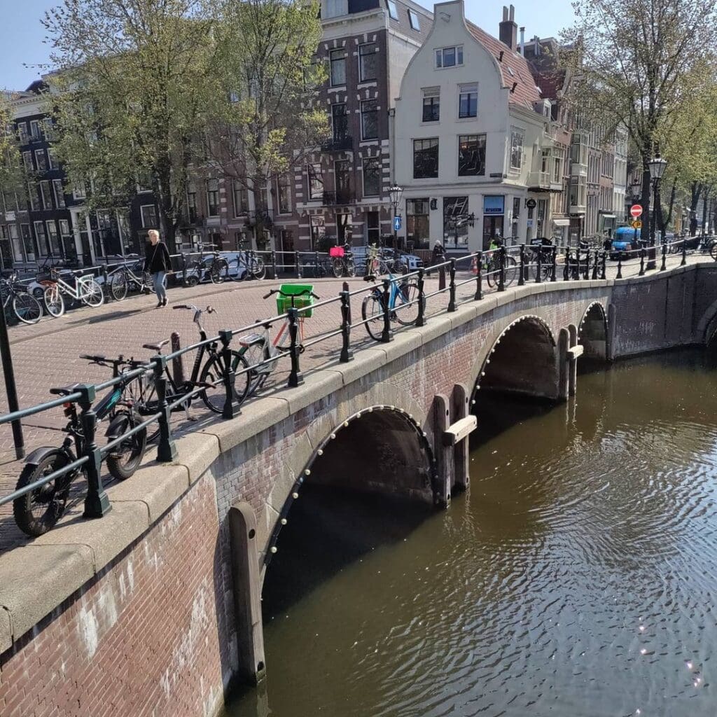
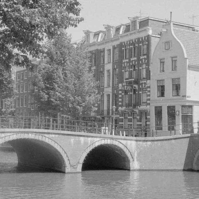
If you have ever stood on the western quay of the Keizersgracht, just south of the Westermarkt, and looked northward along the broad, elm-lined stretch of water toward the soaring Westertoren, you have almost certainly been standing on, or very near, Bridge 51. It is not Amsterdam’s most famous bridge. It carries no trams and bears no official proper name in the municipal registry. Yet Brug 51, which spans the Keizersgracht at the mouth of the Leliegracht, is a distilled, richly layered fragment of the city’s entire urban biography, compressed into roughly fifteen metres of masonry, iron, and (as we shall discover) a quietly revolutionary concrete interior.
The bridge sits at a junction that has been one of Amsterdam’s most painted and photographed intersections for over three centuries. The Keizersgracht, the “Emperor’s Canal,” named in honour of the Holy Roman Emperor Maximilian I, was excavated in 1615 as the second of the three great concentric waterways that form the Grachtengordel, the canal belt that UNESCO inscribed as a World Heritage Site in 2010. At nearly 30 metres wide, it remains the broadest canal in the historic city centre, a fact that gave the 17th-century planners both enormous pride and persistent structural headaches. Bridge 51 sits near its northern end, where the great arc of the canal belt passes directly beside the Westermarkt square and the massive Reformed church of the Westerkerk, whose tower, completed in 1638 to a design by Hendrick de Keyser and his son Pieter, still punctuates the Amsterdam skyline with its blue Imperial crown.
Bridge 51 (Brug eenenvijftig)
Back to the Keisersgracht to continue our journey although if you know the area you may notice we skip a bridge because hey why would the numbers be consecutive? #brug106 we will come back to. Road bridge 51 is located on the northern quay of the Leliegracht spanning the Keizersgracht. It is flanked by #bridge52 (west) and #bridge53 (east), both in the quays of the Keizersgracht and span Leliegracht.
All three bridges are fake antique as they were rebuilt in the early 1980’s along with the previous bridges along the #keisersgracht and whilst you can’t see it from my pictures numbers 51 (north side) and 1982 (south side) can be read on two stones.


The Lily and Its Name
The canal the bridge crosses, the Leliegracht (“Lily Canal”), is a short but historically resonant waterway. Dug after 1612 as the canal belt expanded southward from the Brouwersgracht, it connects the Keizersgracht with the Herengracht and runs along the edge of the Jordaan neighbourhood. Its name belongs to the floral and botanical naming tradition of the Jordaan, a district whose street and canal names, from the Bloemgracht (Flower Canal) to the Rozengracht (Rose Canal), likely reflect the green, garden-like character of the area in its earliest days of development. There is also a specific and plausible etymology: the name traces back to a house known as “In de Witte Lelye” (“In the White Lily”), which stood on the nearby Singel, and the Oude Leliestraat, which runs parallel to the canal. It is a naming chain typical of Amsterdam’s organic urban geography, where a single house sign could give its name to a street, which in turn could give its name to a canal.
Bridge 51 itself carries no formal proper name. In Amsterdam’s municipal numbering system, maintained by the Dienst der Publieke Werken (Public Works Department), bridges in the historic city centre are assigned numerical codes, and numbers 1 through approximately 300 cover the primary canals of the old centre. The number 51 is stamped into the stonework on the north side of the bridge’s parapet, a quiet testament to the city’s bureaucratic precision. Informally, locals have long associated the bridge with its immediate geography: it is the Keizersgracht corner where the Westermarkt’s bustle softens into the quieter residential rhythm of the Leliegracht, and where the silhouette of the Westerkerk is framed, in fine weather, with an almost painterly perfection.
A Foundation in Crisis: The History Begins in 1863
The documented modern history of Bridge 51 does not begin with its construction but with its near-collapse. In 1863, the municipality of Amsterdam conducted a structural inspection of the bridge and found its foundation to be of critically insufficient quality. The Keizersgracht was, at this time, experiencing a broader problem: the shore sides of the canal were sagging dangerously, a consequence of Amsterdam’s perennial struggle with its soft, peat-rich subsoil and the wooden pile foundations that held everything upright, provided they remained perpetually submerged and therefore oxygen-free.
The municipal response was swift and expensive. On 31 May 1864, a public tender was issued for “the construction of a piled foundation with the erection of the masonry piers and moors and the making and setting of all the iron work for the above-mentioned stone Wulf bridge.” The word “wulf” (or “welf”) is critical here: it identifies the bridge type as a fixed masonry vault arch, the traditional form that had given Amsterdam’s canal ring its characteristic silhouette since the 17th century. These bridges did not open for boat traffic. Instead, their graceful stone arches framed the water beneath and carried foot and cart traffic above. The 1864 rebuild came in at under 22,000 guilders, a saving on the 30,000-guilder estimate for the full facility, meaning certain elements were likely simplified or consolidated.
Barely a year after the reconstruction tender, the problem of the sagging canal sides was so severe that city engineers actually debated filling in the Keizersgracht entirely, a proposal that, had it succeeded, would have erased one of the most beautiful streetscapes in all of Europe. Fortunately, cooler heads prevailed.
Lowered and Widened: The 1892 Transformation
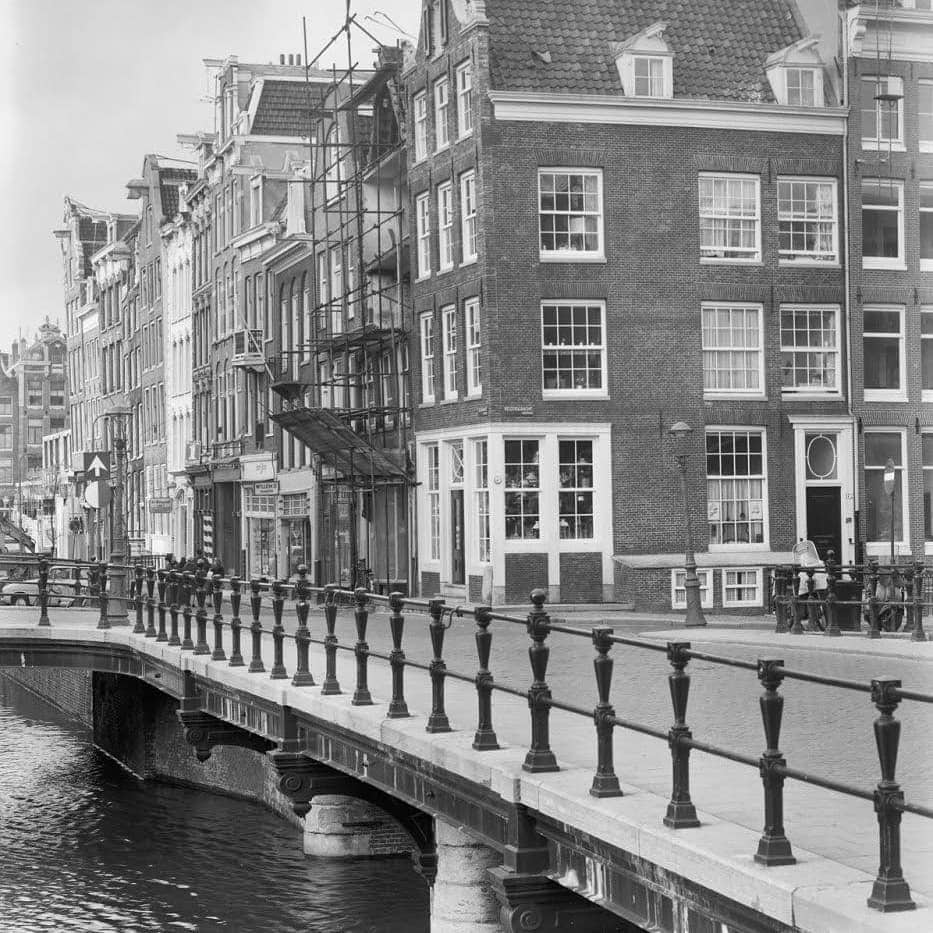
The next major chapter in the bridge’s life came in 1892, and it was driven not by structural failure but by the relentless pressure of modernisation. Bridge 51 was one of three adjacent crossings, along with Bridge 52 and Bridge 53, that needed to be “lowered” (verlaagd) and, in some cases, widened to accommodate the growing demands of urban traffic. The verb “lowered” is slightly misleading to the modern ear: it did not mean the bridge deck was pushed downward, but rather that the high, humpbacked profile of the old masonry vault was flattened to create a nearly level crossing more suitable for horse-drawn trams and heavy goods vehicles. The high-arched wulfbrug silhouette, picturesque as it was, presented a significant grade change for horse-drawn vehicles and was entirely incompatible with the iron rails of a tramway. A photograph from around 1892, now held in the Rijksdienst voor het Cultureel Erfgoed archive and viewable on Wikimedia Commons, captures the Keizersgracht viewed northward from the Westermarkt, with the caption explicitly noting that Bridge 51 had been “lowered and widened” that year. It is a striking document of the tension between historical preservation and functional modernity that has defined Amsterdam’s infrastructure debate for over a century.
The Beautiful Lie: Reconstruction from 1979 to 1982
Nearly a century of relative quiet followed the 1892 interventions. Then, from 1979 to approximately August 1982, the entire bridge complex at the Keizersgracht-Leliegracht junction underwent a comprehensive reconstruction that would become one of the more quietly controversial episodes in Amsterdam’s 20th-century approach to heritage infrastructure.
The reconstruction posed the engineers and the Public Works Department with a familiar dilemma: how do you replace an ageing iron and stone bridge that forms a critical part of a UNESCO-quality historic streetscape, while meeting modern structural standards, modern load requirements, and a modern budget? The answer chosen for Bridge 51 was what critics and admirers alike have since called the “architectural lie” (architectonische leugen): the bridge was given a new structural span made of reinforced concrete, but the exterior was clad in the original pre-numbered stones, carefully dismantled, catalogued, and then reset around the new core to preserve the historic appearance. The stones were numbered before removal specifically to ensure they went back in their original positions. The result is a bridge that looks, to the eye of a casual visitor or even an experienced canal-watcher, like a 19th-century masonry vault bridge. It is, in its structural bones, a 1982 concrete structure in a historic stone coat.
The date stamps embedded in the stonework confirm this layered identity with a kind of deadpan honesty. On the north side of the parapet, the number “51” can be read in the masonry; on the south side, the year “1982” appears. Bridge 51 was the last of the three adjacent crossings to be completed in this reconstruction campaign, finished around August 1982.
This approach, sometimes dubbed a “historical lie” by architectural purists but defended by conservationists as appropriate contextual repair, was part of a broader late-20th-century policy by the Dienst der Publieke Werken to restore the historic visual character of the canal ring after decades of utilitarian interventions. The Reguliersgracht bridges underwent similar treatment. The policy prioritised the urban ensemble over strict material authenticity, and Bridge 51 is one of its clearest examples.
Architectural Character: Stone, Iron, and the Amsterdam School Shadow
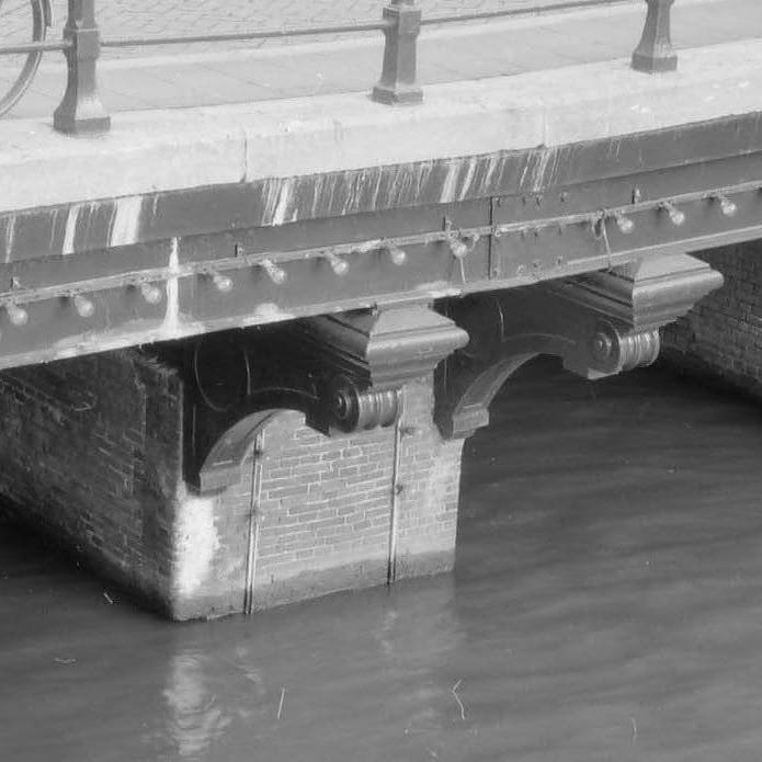
Bridge 51 is a fixed vault bridge (vaste wulfbrug) in its outward form. It carries no bascule mechanism, no drawbridge leaves, and no movable parts. In a canal ring where dozens of bridges must open regularly for boat traffic, this makes it a relatively passive piece of infrastructure, a permanent crossing that does not interrupt the rhythm of the waterway. The Keizersgracht, at this northern section, is primarily a tourist and recreational canal, and the fixed bridge presents no operational problem.
The visible exterior combines natural stone abutments, decorative ironwork railings, and the characteristic granite “nose stones” (neusijzers or neuspalen in Dutch) that protect the bridge corners from being clipped by passing barges. These nose stones, typically made from a harder granite or bluestone, are a standard feature of Amsterdam canal bridges and serve as a silent record of centuries of waterborne commerce. The ironwork of the railings, while not extravagantly decorative, follows the restrained, pragmatic style associated with municipal bridge design of the late 19th and early 20th centuries.
It would be tempting to assign Bridge 51 to Piet Kramer, the towering figure of Amsterdam’s bridge design golden age. Kramer, born in Amsterdam in 1881, worked for the Public Works Department from approximately 1917 and for some 35 years produced hundreds of bridges and bridge-keeper’s houses in the expressive brick and wrought-iron manner of the Amsterdam School. His fingerprints are visible all over the canal belt. However, the specific documented evidence for Bridge 51 points to a bridge whose character is defined more by its 1864 and 1892 rebuilds, in the utilitarian style of the late-19th-century municipal engineering department, than by the Amsterdam School flourishes of the Kramer era. The 1979 to 1982 reconstruction, moreover, was conceived as a conservative restoration rather than a redesign, meaning the bridge’s visual character reflects its 19th-century predecessors rather than any 20th-century architectural vision. The supervising architects and engineers of the late-20th-century reconstruction worked within the Dienst der Publieke Werken, by then under the direction of Dirk Sterenberg’s successors, who applied the department’s established policy of historicising repair for the old city centre.
There is no bridge-keeper’s house (brugwachtershuisje) at Bridge 51. The crossing is too narrow and the canal at this location was controlled from the nearby cluster of bridge operations along the Keizersgracht. Since 2012, all remaining bridge operations in Amsterdam’s centre have been managed remotely from a centralised control room, making the absence of a keeper’s house here largely academic.
Urban Context: The Westermarkt Neighbourhood
To understand Bridge 51 is to understand its surroundings. The bridge stands at the boundary between two distinct urban energies. To the east, across the Keizersgracht, is the Westermarkt square, dominated by the Westerkerk, whose tower (the “Westertoren”) at 85 metres was the tallest structure in Amsterdam when it was completed and remains a defining element of the skyline. The Westermarkt is also home to the Homomonument, three pink granite triangles installed in 1987 as the world’s first public monument dedicated to persecuted LGBTQ+ people, a structure that extends in the form of a small jetty directly above the Keizersgracht. A short walk south along the Prinsengracht brings one to the Anne Frank House. These are not incidental neighbours: they place Bridge 51 at the intersection of Amsterdam’s Golden Age religious heritage, its modern cultural memory, and its living civic identity.
To the west, beyond the bridge and along the Leliegracht, is the Jordaan, one of Amsterdam’s most beloved residential neighbourhoods. The Leliegracht itself, running roughly 400 metres between the Herengracht and the Prinsengracht, is lined with 17th- and 18th-century merchant houses. Near the Keizersgracht end stands a particularly notable corner building, a 1905 Art Nouveau structure sometimes called the Astoria building, whose intricate stonework and curved lines mark the early 20th century’s intervention into the otherwise consistently Golden Age streetscape. At Leliegracht 41 to 43, a pair of Louis XIV-style neck-gabled houses from around 1725 demonstrate the stylistic evolution of Dutch canal architecture across the decades. The former residence of Jan Jacobszoon Hinlopen, a significant 17th-century cloth merchant, shipowner, and collector of paintings, stood near the Keizersgracht corner, making the immediate neighbourhood of Bridge 51 a node of Golden Age commercial and cultural life.
The Bridge Today: A Fixed Stage for Amsterdam Life
Bridge 51 today is a bicycle and pedestrian crossing. It carries no tram lines and no heavy motor traffic. The Keizersgracht at this point is part of a network of streets that prioritise cycles and pedestrians, and the bridge functions essentially as a shared urban square, a small granite-paved platform at the junction of two canal axes where cyclists pause, tourists photograph the Westerkerk, and houseboats rock gently in the wash of passing tour boats.
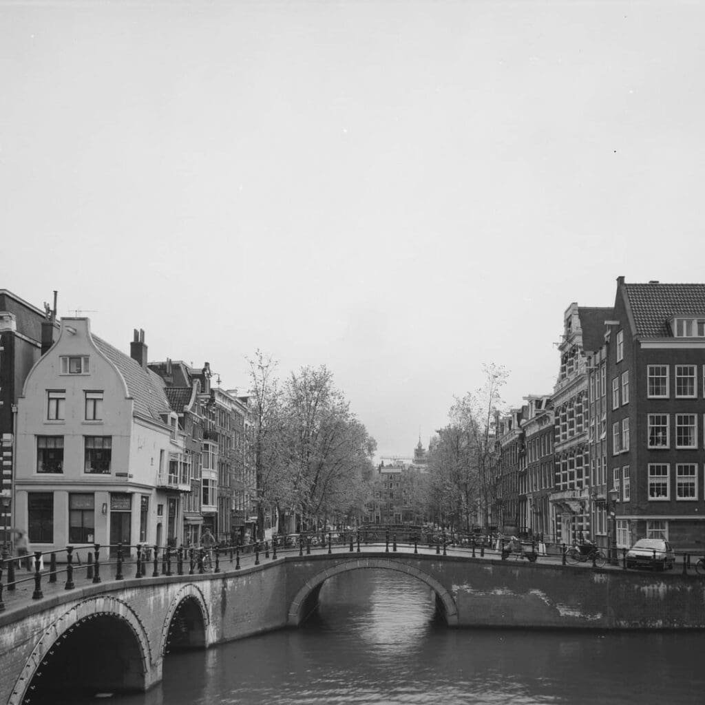
The view from the bridge’s northern railing is one of those accidental masterpieces of Amsterdam urban planning. Looking northwest, the broad Keizersgracht opens toward the Brouwersgracht, its surface a mirror for the elm canopy that edges both quays. The Westertoren rises directly above the roofline of the Westermarkt buildings, its blue-and-gold Imperial crown catching the light on clear days. This is the view that appears in countless photographs and has been reproduced in paintings since at least the 1760s, when Jan Schouten depicted the Keizersgracht at the Leliegracht with the Westerkerk rising in the distance, in a work now held in the public archives.
The bridge’s canal-facing stone abutments bear no commemorative plaques at present. There is no zinloos geweld (senseless violence) memorial or dedication tablet recorded on the structure. The stone number “51” on the north parapet and “1982” on the south parapet are the only inscribed markers, a minimal, almost austere kind of self-documentation in a city that tends to layer its histories invisibly.
Technical Specifications Summary
The following data points summarise what documentary and archival evidence confirms about Bridge 51:
Bridge type: Fixed vault bridge (vaste wulfbrug). The exterior presents as a masonry arch; the structural span is reinforced concrete, installed during the 1979 to 1982 reconstruction.
Materials: Natural stone cladding (original pre-numbered stones, reset in 1982) over a reinforced concrete structural core. Wrought iron railings. Granite nose-protection stones at the canal-facing abutment corners.
Location: Keizersgracht, at the intersection with the Leliegracht (west side) and Bridge 52 (east side). Municipal coordinates approximately 52°22’31.6″N, 4°53’9.6″E (per Wikidata Q41710896).
Catalogue number: 51, per the Index of Bridges in Amsterdam maintained by the Dienst der Publieke Werken.
Key dates: Foundation failure identified, 1863. Reconstruction tender, 31 May 1864. Lowered and widened, 1892. Full restoration reconstruction, 1979 to August 1982.
Designers: The 1864 rebuild was managed by the municipal engineering department; the 1892 lowering similarly. The 1979 to 1982 restoration was executed by the Dienst der Publieke Werken under its late-20th-century leadership.
No bridge-keeper’s house. The bridge is fixed and was controlled as part of the broader Keizersgracht operational cluster; remote operation from the central control room has applied since 2012.
A Final Note on the Art of the Seam
What makes Bridge 51 interesting is not any single dramatic feature but the honesty that lies, paradoxically, within its architectural dishonesty. The pre-numbered stones, meticulously removed and replaced, represent a city’s considered decision that the continuity of visual experience matters: that the person walking from the Westermarkt toward the Jordaan in 1985 should see, more or less, what their great-grandparent saw in 1895. The reinforced concrete inside is a concession to physics and budget. The stone facing is a concession to memory. Between the two, Bridge 51 carries the weight of both.
Stand on it on a spring morning, when the elm leaves are just unfurling along the Keizersgracht and the Westertoren bells begin their carillon, and you are standing in a place that has been crossed, in some form, since at least 1618. The guild merchants and their barges, the horse-drawn trams of 1892, the workmen of 1982 with their numbered stones, and the cyclists of today: Bridge 51 has been, and continues to be, a seam in the fabric of the city, holding two great canals, two neighbourhoods, and four centuries together.
Brug 51 map and location
Bridge 51 is located in the northern quay of the Leliegracht and spans the Keizersgracht. It is flanked by bridges 52 (west) and 53 (east), both in the quays of the Keizersgracht, which lie across the Leliegracht.
There has been a bridge here for centuries. On the map of Balthasar Florisz. van Berckenrode from 1625 a bridge with five passageways was drawn in the Lely Graft over the Keysers Graft. However, the map with the plot division to the south of the Leliegracht between Keizersgracht and Prinsengracht from around 1618 also showed a bridge (five arches). However, Joan Blaeu drew a bridge with three passageways on his map from 1649. In 1748 Cornelis Pronk painted three passages during the solar eclipse of July 25, 1748. A few years later at Jan Schouten again five.


Bridge 51 information and history
The modern history of #bridge51 starts in 1863. The municipality then investigated the foundation of the bridge and it was found that this was of insufficient quality and the bridge had to be renewed. On May 31, 1864, the tender took place for “the construction of a piled foundation with the erection of the masonry piers and moors and“ the making and setting of all the iron work for the above-mentioned stone Wulf bridge ”. The bridge could be rebuilt for less than 22,000 guilders, and the entire facility would have cost more than 30,000 guilders. At that time, the Keizersgracht had a problem with sagging shore sides, which is why it was suggested barely a year later to fill in the Keizersgracht. In 1892 a new tender took place and the three bridges (51, 52 and 53) had to be lowered. It was not until almost a century later that there was work to be done again from 1979 to mid-1982 the bridge complex was under construction, with bridge 51 being completed last (around August 1982). The stones were pre-numbered to make the work go smoothly. Bridge numbers 51 (north side) and 1982 (south side) can be read on two stones. All this to give the bridge an “antique” appearance, while the bridge was given a concrete span although an architectural lie.


Bridge 51
Photos from the archive
1 & 2 Bridge 51 Annemieke van Oord-de Pee, Collectie Het Grachtenboek 1990 ca.
3, 4 5 & 6 Keizersgracht hoek Leliegracht, brug 51. Op de voorgrond links brug 51 en rechts de aanzet van brug 53. Bridge 51, in the foreground the Niek Engelschman bridge, bridge 106. Collectie Bureau Monumentenzorg 1953 ca. t/m 1995 ca.
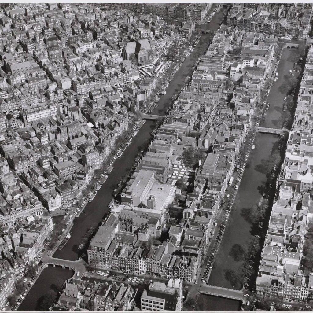
7 Aerial photo of part of Jordaan and part of northern canal belt Description Right Keizersgracht, middle Prinsengracht, above Brouwersgracht and Noordermarkt, left Bloemgracht and Westerstraat and below Leliegracht with Bridge 51. Dienst Publieke Werken; Afdeling Stadsontwikkeling
Collectie 20 april 1970
8 The bridge in 1966 Cultural Heritage Agency of the Netherlands
9 Bridge by Jan Schouten, circa 1760
Sources and Archival References
- Cramberts / Bridges of Amsterdam (bridges.cramberts.com): “Brug Eenenvijftig, Bridge 51: History and Information,” April 2022 (updated October 2023). Primary source for the 1863 inspection, 1864 tender, 1892 lowering, and 1979 to 1982 reconstruction data, including the pre-numbered stone account and the “architectural lie” context.
- Cramberts / Bridges of Amsterdam (bridges.cramberts.com): “Brug Drieenvijftig, Bridge 53: History and Information,” April 2022. Corroborating source for the 1892 joint tender for bridges 51, 52, and 53 and the 1979 to 1982 reconstruction timeline.
- Wikidata, Q41710896: Entry for Bridge 51, Amsterdam. Provides catalogue code, canal identification, and geographic coordinates: 52°22’31.598″N, 4°53’9.600″E. https://www.wikidata.org/wiki/Q41710896
- Wikimedia Commons, Category: Brug 51 (in Amsterdam): Photographic archive including the 1892 RCE photograph and the Stadsarchief Amsterdam materials. https://commons.wikimedia.org/wiki/Category:Brug_51_(in_Amsterdam)
- Wikipedia, “Leliegracht”: Etymology, construction date (post-1612), lock history, and neighbourhood context. https://en.wikipedia.org/wiki/Leliegracht
- Wikipedia, “Keizersgracht”: Canal dimensions, excavation date (1615), naming history (Maximilian I), and bridge inventory. https://en.wikipedia.org/wiki/Keizersgracht
- Wikipedia, “Piet Kramer”: Biographical data on the Amsterdam School bridge architect, working period at the Dienst der Publieke Werken, and stylistic characteristics. https://en.wikipedia.org/wiki/Piet_Kramer
- Grokipedia, “Leliegracht”: Detailed account of the “In de Witte Lelye” etymology and the UNESCO World Heritage inscription (2010) of the Seventeenth-Century Canal Ring. https://grokipedia.com/page/leliegracht
- Cramberts / Bridges of Amsterdam (bridges.cramberts.com): “Bridge Structure Glossary” and general Amsterdam bridges overview. Contextual data on the wulfbrug type, the Dienst der Publieke Werken numbering system, and the “architectural lie” restoration policy. https://bridges.cramberts.com/
- Cramberts / Bridges of Amsterdam (bridges.cramberts.com): “Anton Jolingbrug, Bridge 20”: Comparative data on the 1886 to 1887 lowering of Herengracht bridges, and the Balthasar Florisz. van Berckenrode 1625 map reference confirming a bridge at this location in the early Canal District. https://bridges.cramberts.com/amsterdam/bridges/anton-jolingbrug-bridge-20-amsterdam/
- PICRYL Public Domain Archive: “De Keizersgracht bij de Leliegracht met de Westerkerk, ca. 1760, Jan Schouten.” Historical painting reference confirming the Westerkerk-Keizersgracht-Leliegracht view as an established artistic subject from the 18th century. https://picryl.com/topics/westerkerk+amsterdam+in+art
- Stadsarchief Amsterdam (Amsterdam City Archives): Primary municipal archive holding the construction records, tender documents, and photographic collections referenced in secondary sources above. Researchers should consult the Stadsarchief directly for original tender documentation of 1864 and the 1892 lowering specifications. https://www.amsterdam.nl/stadsarchief/
- Rijksdienst voor het Cultureel Erfgoed (RCE), Beeldbank: Photographic holdings including the c.1892 image of Bridge 51 post-lowering. Accessible via the RCE digital image bank and mirrored on Wikimedia Commons.
- Balthasar Florisz. van Berckenrode, Map of Amsterdam, 1625: Early cartographic evidence of a bridge over the “Lely Graft” in the “Keysers Graft,” with a lock (Lely Sluys) behind it. Referenced in Cramberts Bridge 53 article. Held in multiple Dutch public collections including the Stadsarchief Amsterdam.