
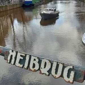
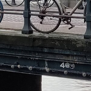
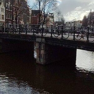
Bridge number 4 (Brug Vier) Heibrug. Another standard fixed bridge in the centre of Amsterdam. Along with bridges 1 and 2 this bridge spans the Singel and forms the connection between the Heisteeg (towards the center) and Wijde Heisteeg (towards the west). Hei or Hay in English is likely named along with both alleys after ‘t Hayblok, a corner house here.
https://nl.wikipedia.org/wiki/Heibrug
A Name Too Polite for Its Own History
There is a particular pleasure in discovering that a bridge once had a name that no respectable city would allow it to keep. The Heibrug, Bridge Number 4 in Amsterdam’s official numbering system, sits today as a modest but picturesque fixed crossing over the Singel, framed by the twin towers of De Krijtberg church and within easy sight of the concert hall that has been entertaining Amsterdammers for well over three centuries. It is, in every outward respect, a serene corner of the historic canal belt.
It was not always described in such terms. Before the city got around to giving it its current genteel name, this bridge answered to something considerably more candid: the Strontenburgerbrug. In the Dutch of the period, stront has never been a polite word, and the name translates, with characteristic directness, as something close to “Dung Castle Bridge.” It is a reminder that the picturesque Amsterdam of today was, for much of its early history, an intensely industrial, frequently malodorous place, and that the Singel, now lined with the stone facades of elegant residences and beloved by photographers, was once the working edge of a city that built ships and smelled like it.
Why the Bridge Stank: Shipyards, Slipways, and the Old Dwarsspui
The Strontenburgerbrug acquired its unflattering designation because of what lay immediately around it. At the end of the Spui stood a boat-builder’s yard; two further shipyards occupied the Dwarsspui, the short alley connecting the Heisteeg with the area known as the Boerenverdriet. These were working industrial sites: shipwrights, caulkers, and joiners plying their trade on the western bank of the Singel, with all the associated waste, noise, and waterway pollution that active shipyards produce. The surrounding neighbourhood had, according to period sources, a reputation to match. The Beschryvinge van Amsterdam of 1665 acknowledges the general character of the area in terms that leave little to the imagination.
This was not, it should be said, unusual for Amsterdam in the sixteenth and early seventeenth centuries. The canals that later generations would come to consider among the most beautiful in the world were, in their working lives, open sewers and industrial drains. Domestic waste, manufacturing runoff, and the byproducts of shipbuilding, brewing, and tanning all found their way into the water. The problem was chronic enough that, on at least one occasion, a King of Amsterdam ordered a canal to be filled in simply because the smell prevented sleep in the adjacent palace.
The informal name Strontenburgerbrug appears in records until approximately 1606, after which the city had begun, gradually and with civic dignity, to assign more presentable titles to its bridges and streets. The name “Heibrug” (Hay Bridge) was already in use by 1665, when it appears in the Beschryvinge van Amsterdam, reflecting the connection to the Heisteeg (Hay Alley) beside which the bridge stands. The alley itself takes its name from a corner house known as ‘t Hayblok, “the Hayblock,” which is documented at this location from the beginning of the sixteenth century. Some sources connect the name also to the Heypoort, or Hay Gate, which stood nearby when the Singel still served as the outer defensive boundary of the medieval city.
The Medieval Origins: A Drawbridge at the City’s Edge
The bridge’s origins are inseparable from Amsterdam’s medieval geography. When the Singel was first dug, it served as a moat, the outermost defensive perimeter of the walled city. Traffic crossing it at this point did so via the Nieuwe Heypoort (New Hay Gate), and the crossing was originally a wooden drawbridge: a functional, raisable structure rather than a fixed span. This arrangement made sense at the edge of a defended city, where the ability to cut off access was as important as providing it.
The bridge in this form is documented on the city plan of Pieter Bast, made in 1599, where it appears annotated as the Hey Steegh crossing. It features again on Balthasar Florisz. van Berckenrode’s celebrated plan of Amsterdam from around 1624. By the late sixteenth century, the city had already expanded well beyond the Singel, the old wall had been demolished, and the west bank of the canal was being developed for residential and commercial purposes. The Singel’s function shifted from moat to inner canal, and the bridge’s function shifted with it: no longer a security checkpoint at the edge of civilisation, it became an everyday urban crossing in an increasingly built-up neighbourhood.
Allard Cornelis Pierson and the Arched Iron Bridge of 1852
For the first two and a half centuries of its recorded existence, the Heibrug remained a wooden structure, periodically repaired and rebuilt as timber aged and traffic increased. By the early nineteenth century, Amsterdam was engaged in a broader programme of replacing its wooden bridges with more durable alternatives, and the Heibrug, which had been rebuilt in one form as recently as 1798, was no exception to the pressures of modernisation.
By mid-century, the existing structure could no longer cope with the traffic passing over it, and the city commissioned a new design. The commission went to Allard Cornelis Pierson, who served as the head of the Stads Fabriekambt, the city’s Works Department. Pierson prepared two proposals: one for another wooden bridge, and one for an iron structure. The iron variant was selected, reflecting the broader shift in nineteenth-century civil engineering toward the new materials that industrialisation had made available.
The resulting bridge was a bolle brug, literally a “bulging bridge,” a term Amsterdammers used for the pleasingly arched iron crossings that the city built during this period. The arch was not merely decorative: a convex profile distributes loads efficiently across the span and, in the era of horse-drawn carts and relatively modest axle weights, was a perfectly adequate structural solution. A photograph taken in 1891 by Jacob Olie, Amsterdam’s meticulous documentary photographer, shows the Pierson bridge still in place, its arched ironwork casting the characteristic curved silhouette that these mid-century bridges shared across the city.
The construction of Pierson’s bridge was not without incident. In 1854, during the associated groundworks, the records note with some alarm the “unexpected loss of the fruit office of the Appeltjesmarkt,” an administrative office for the apple market that stood nearby and evidently fell victim to the construction process. In 1892, further work on the bridge was required, an operation during which a stonemason suffered the misfortune of receiving boiling lead in his eye and had to be taken to hospital. Bridge maintenance in the nineteenth century was an imprecise and occasionally hazardous business.
The Flattening: From Arched to Girder by 1895
The transition from arched iron bridge to flat girder bridge is one of the recurring structural narratives of Amsterdam’s canal crossings, and the Heibrug followed it with reliable fidelity. Jacob Olie’s 1895 photograph, taken at approximately the same location as his 1891 image, already shows a flat bridge in the scene, the convex arch of Pierson’s design replaced by the lower, horizontal profile of a plate-girder span.
The reasons for this change are practical and historically consistent with patterns seen across the city. Amsterdam’s tram network began operating in 1875, and the expanding system placed new demands on bridge surfaces: tram tracks require level, even surfaces, and the arched profile of a bolle brug, charming as it was, created a pronounced hump that complicated tram operations and was increasingly ill-suited to the heavier carts and commercial vehicles of the late nineteenth century. The broader municipal policy from around 1860 onward was to replace the high-arched crossings with flat plate-girder bridges wherever traffic conditions warranted it, and the Heibrug’s position on a reasonably busy urban crossing made it a logical candidate.
The result was a bridge that sacrificed visual drama for functional efficiency: lower, flatter, and better suited to the wheels and loads of a modernising city. It is, in its modest way, a small chapter in the longer story of how the demands of traffic engineering have shaped the physical character of Amsterdam’s canal crossings.
The Two Plans That Could Have Erased It
The Heibrug might not exist today in anything like its current form, or at all, had two separate twentieth-century proposals proceeded to completion. That neither did is a matter of some quiet good fortune for the neighbourhood.
The first threat came in 1913, when municipal planners investigated the possibility of widening the Leidsestraat. The Leidsestraat runs diagonally southwest from the Koningsplein, and proposals to widen it for improved traffic flow had been circulating for some time. The implications for the Heibrug and the surrounding Heisteeg were serious: widening the street would have required demolition works that would have substantially altered, or entirely eliminated, the character of this corner of the Singel. The neighbourhood was, in the end, spared, though not because the planners had abandoned their ambitions.
The second proposal came in 1920, and it was more radical. The municipality had developed a plan to demolish the Heisteeg, Spui, and Singel complex wholesale, relocating the bridge further southward as part of a comprehensive reorganisation of the area. Urban planning in the early twentieth century often embraced this kind of bold, clearance-based thinking: the idea that old, irregular, narrow urban fabric should give way to rational, wide, modern streets was a powerful current in European civic design of the period, and Amsterdam was not immune to it.
Neither plan proceeded. The reasons for their abandonment are not entirely clear from the available records, and may reflect a combination of cost, public opposition, political change, and the practical difficulties of demolishing and rebuilding on the scale proposed. Whatever the cause, the Heisteeg survived, and the Heibrug remained where Pierson’s original design had placed it: a small, fixed crossing at one of the Singel’s quieter stretches, unremarkable enough to be overlooked and apparently just unremarkable enough to escape the grander ambitions of successive planning generations.
Postwar Maintenance: 1958 and 1983
The bridge that emerged from the twentieth century intact still required care to remain functional. Around 1958, the bridge deck was renewed, a standard maintenance intervention that replaced worn or damaged surface elements while preserving the underlying structure. In 1983, a further reprofiling of the bridge deck was carried out, an adjustment to the surface geometry designed to meet the requirements of modern traffic, including the clearances and level tolerances expected of a contemporary urban crossing. These interventions are characteristic of the low-key, persistent maintenance that keeps Amsterdam’s bridges usable without necessarily making them visible as objects of heritage: the work is practical, the results are invisible, and the bridge continues to function.
The current structure is classified as a fixed girder bridge (vaste ligger brug), a designation that reflects both its structural type and its operational status. It does not open, it does not swing, and it offers no drama to canal boat crews navigating beneath it. It simply spans the Singel, carrying pedestrians and cyclists between the Heisteeg on the canal side and the Wijde Heisteeg on the western bank.
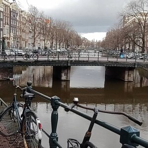
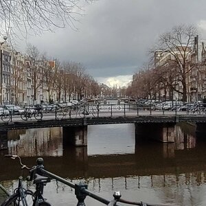
The View from the Bridge: De Krijtberg, the Odeon, and Bridge 2
Standing on the Heibrug today, the contrast with its industrial and aromatic past could scarcely be more complete. The view is one of the more quietly satisfying in central Amsterdam, precisely because it does not announce itself with the theatrical grandeur of the Magere Brug or the monumental weight of the Blauwbrug.
To the south, the most immediately striking landmark is De Krijtberg, the Jesuit church at Singel 446 whose twin Neo-Gothic towers rise sharply above the canal’s roofline. The church takes its name from the merchant house “De Crijtbergh” (The Chalk Mountain) that previously stood at this address. When the Catholic Church regained the right to build publicly in the Netherlands following the restoration of the episcopal hierarchy in 1853, three canalside houses were demolished to make way for the current building, which was designed by Alfred Tepe and consecrated in 1883. Its narrow, tall facade, a response to the compressed urban site, gives it a certain intensity that is striking from the water level perspective of the bridge deck.
Slightly further along the Singel, at number 460, stands the Odeon, a building that has been continuously in use as a social and cultural venue since it was first constructed as a beer brewery in 1663. In the 1830s it was rebuilt as Amsterdam’s first concert hall, and its guest list over the centuries has included figures as diverse as David Bowie and Elton John. Today it houses a concert hall, bars, and clubs, occupying a position in Amsterdam’s nightlife that is improbable given the building’s three-and-a-half-century pedigree. The Odeon’s canal facade is visible from the bridge, an unexpected adjacency between seventeenth-century brick and contemporary evenings out.
Looking south along the Singel from the Heibrug, the attentive visitor can also pick out the profile of Bridge 2, the Heiligewegsluis, some distance down the canal. The Heiligewegsluis is, in its own right, a bridge with considerable historical layering: it once marked the outer boundary of the medieval city, connected to the Heiligewegspoort (demolished in 1663 when the city’s boundary shifted southward), and now carries tram lines 2 and 12 across the Singel at a width of more than 45 metres. Spotting it from Bridge 4 gives a useful sense of the scale of the Singel’s bridge sequence and the way in which this stretch of the canal, between the Bloemenmarkt at Muntplein and the Koningsplein to the north, concentrates such a density of historical incident into so short a distance.
The Bridge That Stayed
The Heibrug is not a bridge that demands attention. It does not carry the city’s widest intersection, like Bridge 1. It was not designed by the founder of a famous architectural school. It has no lock mechanism, no counterweights, no bascules. It is, in the useful phrase, a modest fixed crossing, and it has been one, in one material or another, for more than four centuries.
What makes it worth a pause is precisely its persistence. The name that the city spent centuries sanitising is still half-legible to anyone who knows to ask about it. The arched iron bridge that Pierson designed in 1852 survived long enough to be photographed by Olie in 1891, before being quietly replaced by something flatter and less romantic. The demolition plans of 1913 and 1920 passed over it, for reasons we cannot now entirely recover. The maintenance crews of 1958 and 1983 renewed its deck and adjusted its profile, keeping it functional without reimagining it.
And it remains: Bridge Number 4 on the Singel, connecting the Heisteeg to the Wijde Heisteeg, carrying pedestrians across the same water that once ran beneath a drawbridge, a city gate, and a neighbourhood that smelled so comprehensively of the shipyards that the city named the crossing in their honour, and then thought better of it.
Research compiled February 2026. Key Dutch-language sources consulted include the Wikipedia article on the Heibrug (nl.wikipedia.org), the Bruggen van Amsterdam archive (bruggenvanamsterdam.nl), the Ensie encyclopedia entry on the Heibrug, and the Beschryvinge van Amsterdam (1665). Photographic evidence for the 1891 bolle brug and the 1895 platte brug is attributed to Jacob Olie’s documentary photography, held in the Stadsarchief Amsterdam. For primary archive material on the Pierson commission, the 1913 and 1920 planning proposals, and the 1958/1983 maintenance records, the Stadsarchief Amsterdam (stadsarchief.amsterdam.nl) holds the relevant municipal files under the Gemeentewerken and Publieke Werken classifications.
Key Facts at a Glance
Official name: Heibrug Bridge number: 4 (Brug 4) Location: Singel, at the junction with Heisteeg and Wijde Heisteeg Type: Fixed girder bridge (vaste ligger brug) Former name: Strontenburgerbrug (until approximately 1606) Reason for former name: Environmental nuisance from two shipyards on the Dwarsspui and a boat-builder’s yard at the Spui Named after: The Heisteeg (Hay Alley), itself named after the corner house ‘t Hayblok (documented from early 1500s); also possibly connected to the Heypoort (Hay Gate) Early form: Wooden drawbridge, serving the Nieuwe Heypoort; visible on Pieter Bast’s city map (1599) Previous fixed bridge: From 1798 1852: Design by Allard Cornelis Pierson (Stads Fabriekambt) for an iron arched (bolle brug) bridge; iron variant chosen over wooden alternative 1854: Construction disruption: accidental loss of the Appeltjesmarkt fruit office 1891: Pierson’s arched bridge documented in photograph by Jacob Olie 1892: Further works; stonemason injured by boiling lead 1895: Jacob Olie photograph shows transition to flat (platte brug) girder bridge 1913: Municipal investigation into widening the Leidsestraat; demolition threat averted 1920: Municipal plan to demolish Heisteeg-Spui-Singel complex and relocate bridge southward; plan abandoned ca. 1958: Bridge deck renewed 1983: Bridge deck reprofiled Adjacent landmarks: De Krijtberg church (Singel 446, Alfred Tepe, 1883); Odeon building (Singel 460, originally 1663) View southward: Heiligewegsluis (Bridge 2) visible along the Singel
Bridge number 4 (Brug Vier) Heibrug.
Both the Heibrug and both nearby alleys are said to be named after ‘t Hayblok, a corner house that was once located here. The name Heybrug, however, already appears in the Beschryvinge van Amsterdam, its first origin from the huyze der heeren van Aemstel and Aemstellant of 1665 and is said to be related to the Heypoort or Hayepoort. The bridge was called the Strontenburgerbrug before 1606; the neighborhood stank quite a bit because of two shipyards that were located here on the connection with the Spui (then still water), which caused environmental nuisance. In the year 1606 Amsterdam started an attempt to record street names, which would later only partly lead to definitive naming.
Images from the Archive
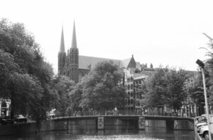

- Singel 412 – 446 v.r.n.l., with at number 446 the R.K. Church De Krijtberg. In the foreground the Heibrug
https://archief.amsterdam/beeldbank/detail/70559742-8527-11e4-915c-2be480126594 - Singel (Heisteeg), Heibrug (Bridge 4) blueprint 1852
https://archief.amsterdam/beeldbank/detail/7c056291-817c-3cdf-508d-aab8b2633643
Bridge number 4 (Brug Vier) Heibrug. Map of location.
The bridge spans the Singel and forms the connection between the Heisteeg (towards the center) and Wijde Heisteeg (towards the west).
