A Utilitarian Tram Bridge on the Utrechtsestraat at the Herengracht, Currently Under Active Restoration
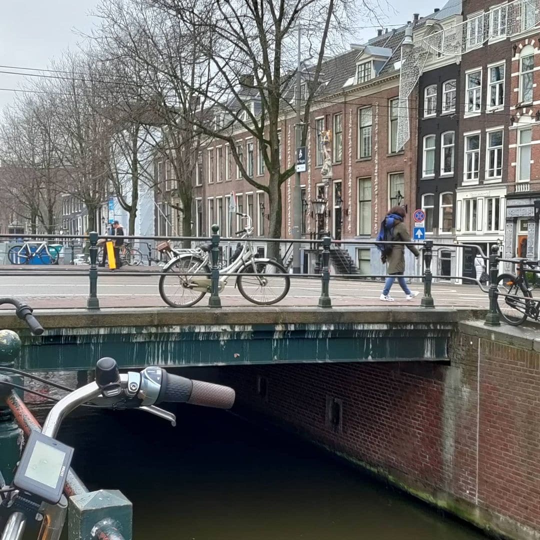
Bridge 34 is an honest bridge. It does not carry a famous name. It was not designed by Piet Kramer or adorned with sculptures by Hildo Krop. It is, in the precise words of the bruggenvanamsterdam.nl register, a rather utilitarian road bridge, and it has never pretended to be anything else. What it does offer, to the patient observer, is something no amount of decorative ironwork can supply: a position at the very end of the Herengracht’s most prestigious stretch, a tram line that has crossed it since 1948, a structural history that begins with a sluis drawn by Daniël Stalpaert in 1662, and a relationship with the most significant bank building in the Dutch capital that shaped the width of the street it carries. Bridge 34 is also, as of January 2026, a bridge under active restoration. Anyone visiting Amsterdam before July of this year will find it surrounded by construction fencing, with its four corner wing walls being reinforced with steel piles. The timing makes this one of the most live and current entries in the entire series.
This rather utilitarian road bridge, over which tram line 4 has been running since 1948, is located in Utrechtsestraat and crosses Herengracht.
Unlike most bridges in the centre of the city, this bridge was rebuilt when the tram was already a planned mode of transport around 1884 and it was also widened for road traffic.
It is the second-to-last bridge before the Herengracht flows into the Amstel under the Hendrick Jacobsz. Staetsbrug (bridge 35). The bridge, itself not a monument, is surrounded by municipal and national monuments, of which the Amsterdamsche Bank building is the biggest eye-catcher. The location of this bridge is in the heart of Amsterdam, a city known for its picturesque canals and historic architecture. As pedestrians and cyclists cross this bridge, they are greeted by the stunning surroundings that make Amsterdam a beloved tourist destination. The Herengracht, one of the most prestigious canals in the city, flows gracefully beneath this bridge, offering a charming view of the Amstel River. The bridge holds a significant place in the city’s history and serves as a symbol of its rich cultural heritage. The Amsterdamsche Bank building, with its majestic presence, adds to the grandeur of the surrounding area. As one gazes upon this architectural marvel, they are transported to a bygone era, where elegance and opulence reigned supreme. The combination of the bridge and the surrounding monuments creates a harmonious blend of old and new, showcasing the timeless beauty of Amsterdam.


1. Etymology and Naming: An Unnamed Bridge on a Street Named for a City
Bridge 34 carries no official name. As with Bridges 6, 7, 8, and several others in Amsterdam’s numbering system, it simply bears its number in the municipal register and has never acquired either an official or an enduring informal one. The café on the corner of the Utrechtsestraat and the Herengracht is named Brug 34 after the bridge, and that naming is noted in the bruggenvanamsterdam.nl bridge register as a local detail worth recording. But the café’s adoption of the number is as close as the bridge has come to a name.
The street it carries, however, has one of the clearest etymologies of any road in the canal belt. The Utrechtsestraat was extended from its medieval origins to form one of the radial routes connecting Amsterdam’s historic centre to the city gates during the Fourth Expansion of the 17th century. It pointed, as its name declared, toward Utrecht, the ancient bishop’s city to the south that had been an important trading partner and destination for Amsterdam merchants since the Middle Ages. The Utrechtsestraat was therefore not just a residential street but a commercial artery: the road along which goods, coaches, and travellers moved between the two most important cities in the northern Netherlands.
That commercial character persisted well into the modern era. The Utrechtsestraat today is one of the most celebrated independent shopping streets in Amsterdam, known for its concentration of specialist food shops, wine merchants, bookshops, and small restaurants. It runs from the Frederiksplein in the south to the Rembrandtplein in the north, crossing the Prinsengracht, Keizersgracht, and Herengracht in quick succession, with Bridge 34 marking the last of those three crossings before the street meets the Rembrandtplein.
2. Structural Evolution: From Stalpaert’s Sluis of 1662 to Reinforced Concrete in 2017
The documentary record for Bridge 34 is rich and precise, tracing the crossing from the earliest planned phase of the canal ring to a 2017 reconstruction that replaced the entire deck.
On Jacob Bosch’s map with the Fourth Expansion of around 1679, a sluis with a bridge is drawn here, with the quay of the Weesperveer noted in the section toward the Amstel. City architect Daniël Stalpaert had already drawn those sluices on the design section of his map of 1662, but it was then still mainly empty land at the Utrechtse straet and Heere Graft. The word “sluis” here refers to a functional hydraulic lock, not simply a stone bridge: at this point on the Herengracht, close to the Amstel, there was a working lock allowing water levels to be managed between the canal and the river. This distinguishes Bridge 34’s early history from those of the Kaasmarktsluis and Beulingsluis, where “sluis” was used in the older sense of simply meaning a stone bridge.
The first decisive modern transformation came in the 1880s. The request came around 1884 from the shipping side, which found it strange that Bridge 35 was “high” and could be passed underneath, but that one then came up against this low bridge barely 100 metres away. At the same time as the raising of the bridge, it was also widened for road traffic. The Amsterdamsche Omnibus Maatschappij had requested this. The bridge was made 14.10 metres wide, with a carriageway of 9.60 metres and pavements of 2.25 metres on each side.
The sequence of decisions that followed in the early 20th century directly involved the bank building that now dominates the corner. In 1907 it was considered whether the Utrechtsestraat could be used as a radial road out of the city; it would need to be widened to 25 metres. This was considered too expensive, and the radial road function went to the Vijzelstraat, which required the demolition of many buildings. In 1913 the question of widening was considered again. When the building line for the new Amsterdamsche Bank construction was established, this was taken into account, and by 1920 the street was to become 20 metres wide between Rembrandtplein and Herengracht, compared to 11.5 metres previously.
The contested renovation of the 21st century is also documented. In 2009, the bridge became a point of dispute in the renovation of the Utrechtsestraat and surroundings. The contractors could not agree on the approach to the bridge. Work was stopped for at least a year due to disagreement about the thickness of the asphalt and the low clearance height of the bridge. In November 2010 it could be confirmed that the bridge was sturdy enough for traffic. By March 2011 there was renewed discussion about whether the two other bridges in the Utrechtsestraat should also be adapted. Research showed they could last another 10 years.
The most recent structural intervention was the most comprehensive. In 2017 a bridge of prestressed concrete girders and a concrete road deck was installed between two renewed abutments over the Herengracht.
And the work is not finished. From 6 January to mid-July 2026, work is underway on Bridge 34 over the Herengracht in the Utrechtsestraat. The four oblique walls at the corners of the bridge, the wing walls (vleugelmuren), are in poor condition. They are therefore being reinforced with steel piles. After the work the wing walls will last at least another 30 years and will retain the same appearance. The preparation work involved replacing an old gas pipe in the ground beside the bridge. In January 2026 work began on the renovation of the wing walls of Bridge 34 in the Utrechtsestraat over the Herengracht.
3. Architectural Lineage: No Amsterdam School Attribution, but a Famous Neighbour
Bridge 34 carries no architectural attribution to Piet Kramer, Johan van der Mey, or any other named designer in any source consulted for this post. It is a product of successive Publieke Werken engineering interventions across the late 19th, early 20th, and early 21st centuries, each generation replacing or adapting what the previous one built. The 2017 reconstruction in prestressed concrete represents the most radical change: the bridge deck itself is now a modern concrete structure, making Bridge 34 the only crossing in this series from which the historical fabric has been most substantially replaced.
The bridge, itself not a monument, is surrounded by municipal and national monuments, of which the Amsterdamsche Bank building is the biggest eye-catcher.
That building deserves a closer look. In 1917, architect B.J. Ouëndag received the commission from the board of the Amsterdamsche Bank for a new building. The chosen site was a large plot on the Herengracht. The building plan only became possible after the municipality agreed to lift the protection of the garden on the site. In return, the Amsterdamsche Bank gave up a strip of 5.25 metres along the Utrechtsestraat so that the street could be widened. A gallery of 3.75 metres along the Utrechtsestraat was also to be built for pedestrians. In 1926, H.P. Berlage joined the design team. The demolition of the existing buildings was completed in 1926, and construction began in 1927. The sculptures are by Lambertus Zijl.
The Amsterdamsche Bank was established on 5 December 1871 by a group of mainly German investors. A subsequent head office building on Rembrandtplein, designed by Bert Johan Ouëndag and completed in 1932, is a notable Art Deco landmark of Amsterdam. The building now known simply as The Bank occupies the entire block between the Herengracht, Utrechtsestraat, Rembrandtplein, and Amstelstraat, nine and in places ten storeys tall, in a style characterised by the amsterdam-monumentenstad.nl database as “Berlagiaans, in de geest van de Amsterdamse School.” The strip of pavement that the Amsterdamsche Bank gave up along the Utrechtsestraat in exchange for its building permit is the precise reason that Bridge 34 is as wide as it is today: the street widening and the bridge widening were part of the same negotiated urban deal.
The building is built between 1926 and 1932, to a design by B.J. and W.B. Ouëndag, with Berlage acting as supervisor and responsible among other things for the characteristic corner tower. The robust building is embellished with granite sculptures by Lambertus Zijl and decorated with many copper and bronze ornaments.
4. Urban and Social Context: Tram 4, the Second-to-Last Bridge, and a Corner Café
This rather utilitarian road bridge, over which tram line 4 has been running since 1948, is located in the Utrechtsestraat and crosses the Herengracht. It is the second-to-last bridge before the Herengracht flows into the Amstel under the Hendrick Jacobsz. Staetsbrug (Bridge 35).
The tram detail is worth lingering on. Tram line 4 runs from Central Station through the Rokin, across the Rembrandtplein, along the Utrechtsestraat, and out through the southern neighbourhoods. It is one of the oldest and most heavily used tram routes in the city. Every tram on that line crosses Bridge 34 several times a day, as it has since 1948. The fact that the 1884 widening was requested partly by the Amsterdamsche Omnibus Maatschappij, the predecessor of the modern tram network, means that the bridge has been shaped by transit demands for over 140 years.
The bridge’s position as the second-to-last Herengracht crossing before the Amstel gives it a particular character within the canal’s geography. The Herengracht at this point has already passed through its most celebrated stretches: the Golden Bend to the north, the Reguliersgracht junction, and the long series of protected canal houses. What remains here is a more functional, transitional Herengracht, where the prestige of the canal belt gives way to the working waterfront edge of the city.
The café Brug34 (now called Nate) on the corner of the Utrechtsestraat and the Herengracht took its name directly from the bridge, and the café’s own description of its location confirms the bridge’s role as a neighbourhood landmark: “When this special location on the corner of the Utrechtsestraat and the Herengracht became available, we did not have to think twice.” The café serves as a meeting point for locals, expats, and tourists, and its name is the most direct evidence that Bridge 34, despite having no official name of its own, has lodged itself in the identity of this corner of the city. Now known as Nate it still is a beloved gem on Utrechtsestraat.
The Museum Willet-Holthuysen at Herengracht 605, with its preserved 17th-century interior and formal garden, is a five-minute walk along the canal. The Tassenmuseum Hendrikje (Museum of Bags and Purses) at Herengracht 573 is between the bridge and the museum. The Rembrandtplein, with all its associated nightlife and the Tuschinski cinema, is a two-minute walk to the north along the Utrechtsestraat.
5. Technical Specifications
Based on confirmed sources, the following can be stated:
- Bridge type: Fixed plate or girder bridge (vaste plaat- of balkbrug), prestressed concrete girders and concrete road deck installed 2017
- Location: Utrechtsestraat over the Herengracht, Amsterdam-Centrum
- Canal: Herengracht (UNESCO World Heritage Canal Belt, listed 2010)
- Position on the Herengracht: Second-to-last bridge before the canal enters the Amstel; Bridge 35 (Hendrick Jacobsz. Staetsbrug) is the final crossing
- Tram: Line 4 (since 1948)
- First documented: Daniël Stalpaert’s city map, 1662 (as a planned sluis and bridge in undeveloped land); Jacob Bosch’s Fourth Expansion map, around 1679 (as a completed sluis with crossing)
- 1884 intervention: Raised and widened for road traffic and tram use; width set at 14.10 metres (carriageway 9.60m, pavements 2.25m each side)
- 1920 onward: Street widened to 20 metres in connection with the Amsterdamsche Bank construction; the bank gave up a 5.25 metre strip along the Utrechtsestraat as part of the building permit agreement
- 2009 to 2011: Contested renovation; work halted for over a year due to disputes over asphalt thickness and bridge clearance height; confirmed structurally sound for traffic November 2010
- 2017: Full reconstruction with prestressed concrete girders and concrete road deck, between two renewed abutments
- 2026 (current): Wing wall (vleugelmuur) reinforcement works, January 2026 to mid-July 2026; four corner walls being reinforced with steel piles; bridge remains open with reduced space for pedestrians, cyclists, and vehicles; old gas pipe replaced during preparation works
- Monument status: Not a monument (geen monument); surrounded by gemeentelijke and rijksmonumenten
- Café named after bridge: Brug34, Utrechtsestraat 19, Amsterdam
Sources Consulted
- Bruggenvanamsterdam.nl, bridge register entry for Brug 34: www.bruggenvanamsterdam.nl/herengracht_hoek_utrechtsestraat.htm
- Wikipedia (nl), “Brug 34”: nl.wikipedia.org/wiki/Brug_34
- Bridges.cramberts.com, “Brug Vierendertig, Bridge 34, Amsterdam”: bridges.cramberts.com/2022/04/03/brug-vierendertig-bridge-34-amsterdam/
- Gemeente Amsterdam, “Brug 34 in Utrechtsestraat: werkzaamheden vanaf 6 januari”: www.amsterdam.nl/projecten/bruggen/maatregelen/brug-34-herengracht/nieuws/werkzaamheden/
- Aan de Amsterdamse Grachten, “Hier werken we in 2026 aan bruggen en kademuren,” January 2026: aandegrachten.amsterdam/hier-werken-we-in-2026-aan-bruggen-en-kademuren/
- Amsterdam Monumentenstad, “Herengracht 589 to 595, Amsterdamsche Bank”: www.amsterdam-monumentenstad.nl/database/grachtenboek_objecten.php?id=6967
- Wikipedia (en), “Amsterdamsche Bank”: en.wikipedia.org/wiki/Amsterdamsche_Bank
- Wikipedia (en), “Rembrandtplein”: en.wikipedia.org/wiki/Rembrandtplein
- Stedebouw en Architectuur, “Rijnboutt herbestemt bankgebouw” (on the Ouëndag and Berlage building): www.stedebouwarchitectuur.nl/artikel/rijnboutt-herbestemt-bankgebouw
- SGS Search, “The Bank, Herengracht 595, Amsterdam”: www.sgssearch.com/references/energy-references/the-bank,-amsterdam.html
- UNESCO World Heritage Atlas, “Seventeenth-Century Canal Ring Area of Amsterdam”: whc.unesco.org/en/urban-heritage-atlas/Amsterdam/
- Wikipedia (en), “Herengracht”: en.wikipedia.org/wiki/Herengracht
- Brug34.nl, “About Brug34”: www.brug34.nl/en/
- Wikimedia Commons, Category: Brug 34 (Herengracht): commons.wikimedia.org/wiki/Category:Brug_34_(Herengracht)
Map and location of Bridge 34
Bridge 34 is located on the Utrechtsestraat where it crosses the Herengracht a few steps away from the famous Rembrandtplein. It is the penultimate bridge before Herengracht under Hendrick Jacobsz. Staetsbrug (bridge 35) flows into the Amstel. The old Amsterdamsche Bank building is the most known landmark closeby.


What3 Words – ///brave.defended.chapels
Bridge 34 History and Information
In 1907 it was investigated whether the Utrechtsestraat could be used as a radial road out of the city meaning it would have to be widened to 25 meters. It was considered too expensive and instead Vijzelstraat became the radial road and many of its buildings were demolished instead. In 1913 it was re-examined whether broadening the bridge was necessary to take into account the building line of the new Amsterdamsche Bank. The bridge was widened again around that time as the street would then be 20 meters wide between Rembrandtplein and Herengracht and then the bridge would be narrower around 11.5 meters. It was not until late 1927 that the construction of the bank started, but by then the bridge was already widened to accommodate it.
In the 21st century, the bridge became a point of contention in the renovation of Utrechtsestraat and its surroundings from 2009. The contractors could not agree on how to tackle the said bridge. Work stalled for at least a year due to disagreements regarding the thickness of the asphalt and the lowness of the bridge. In November 2010, it could be ascertained that the bridge was sturdy enough for traffic. As early as March 2011, there was renewed discussion as to whether the other two bridges on Utrechtsestraat should also be modified. After investigation, it was found that they would last another 10 years. In 2017, a bridge of prestressed concrete girders and a concrete road surface between two renovated abutments lies across the Herengracht. In the 21st century, the bridge became a point of contention in the renovation of Utrechtsestraat and its surroundings from 2009. The contractors could not agree on how to tackle the said bridge. Work stalled for at least a year due to disagreements regarding the thickness of the asphalt and the lowness of the bridge. In November 2010, it could be ascertained that the bridge was sturdy enough for traffic. As early as March 2011, there was renewed discussion as to whether the other two bridges on Utrechtsestraat should also be modified. After investigation, it was found that they would last another 10 years. In 2017, a bridge of prestressed concrete girders and a concrete road surface between two renovated abutments lies across the Herengracht. The bridge of prestressed concrete girders and a concrete road surface between two renovated abutments across the Herengracht was constructed with great care and attention to detail.
Public Domain Images

1. Wikimedia Commons: “Brug 34, Herengracht” contemporary photographs The Wikimedia Commons category for Bridge 34 holds photographs of the current bridge structure, showing its relationship with the Amsterdamsche Bank building and the Herengracht. Available under free licences. URL: https://commons.wikimedia.org/wiki/Category:Brug_34_(Amsterdam) Attribution: “Wikimedia Commons, Category: Brug 34 (Herengracht). Available under the licence specified on each file’s description page.”

2. Stadsarchief Amsterdam Beeldbank: “De Amsterdamsche Bank gezien vanaf de Herengracht, ca. 1932” Referenced in the Amsterdam Monumentenstad database for the Amsterdamsche Bank building (Herengracht 589 to 595) as a historical photograph showing the bank building and the immediate context of Bridge 34, taken shortly after the building’s completion. Available via the Stadsarchief Beeldbank at archief.amsterdam. URL: https://archief.amsterdam/beeldbank (search: “Amsterdamsche Bank Herengracht Utrechtsestraat”) Attribution: “Collectie Stadsarchief Amsterdam. Available for non-commercial use with attribution.”

3. Caspar Philips Jacobszoon, “Grachtenboek,” 1768, Stadsarchief Amsterdam The Grachtenboek drawings show the Herengracht facades at the Utrechtsestraat crossing as they appeared in the mid-18th century, predating both the Amsterdamsche Bank building and the modern bridge. Referenced in the Amsterdam Monumentenstad database entry for Herengracht 589 to 595. Fully in the public domain as an 18th-century work. URL: https://archief.amsterdam/beeldbank (search: “Grachtenboek Herengracht Utrechtsestraat Philips Jacobszoon 1768”) Attribution: “Caspar Philips Jacobszoon, Grachtenboek, 1768. Collectie Stadsarchief Amsterdam. Public domain.”