
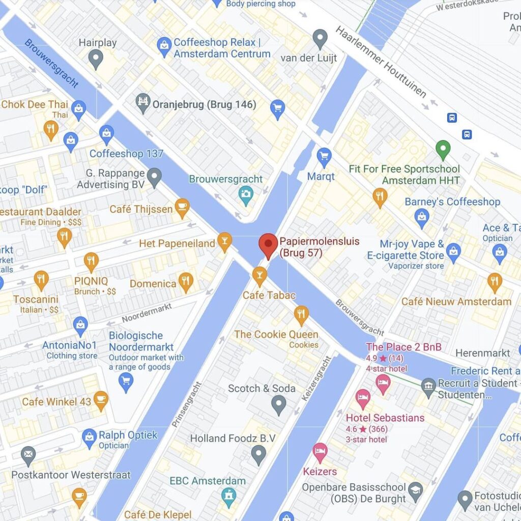
Papiermolensluis (Bridge 57 Paper Mill Lock)
Bridge 57 is a vaulted bridge in Amsterdam Centre. A lock is the “old” designation for stone bridge, although there was also a lock here.
This road traffic bridge forms the connection between the eastern quays of the Prinsengracht and the Korte Prinsengracht over the Brouwersgracht. This intersection of the Brouwersgracht and Prinsengracht is a main supply route from the Westerdok and the IJ into the city making it one of the busiest water hubs in the city. The bridge has been a municipal monument since 1995 and it shares the southwestern quay wall with another monument the Lekkeresluis.
The name comes from a sign that once hung on the corner house on the Brouwergracht; a paper merchant who kept his trade there was known as “de Papiermolen”.


At the northern tip of the Prinsengracht, where three of Amsterdam’s most storied waterways converge, a modest stone arch carries the weight of nearly four centuries of city life. Brug 57, the Papiermolensluis, is easy to walk across in fifteen seconds. Understanding it takes considerably longer.
A Name Born from a Hanging Sign
The first thing to settle about the Papiermolensluis is what its name actually means, and where it came from. The Dutch word sluis translates as “lock” or “sluice,” but in the older, vernacular tradition of Amsterdam bridge-naming, it served as a general designation for any stone bridge, regardless of whether a working lock was also present. In the case of Brug 57, there was indeed a functional lock here at one time, controlling water levels between the main canal system and the adjacent Jordaan district. Both meanings, therefore, apply simultaneously.
The first half of the name is more colourful still. Papiermolensluis means, literally, “Paper Mill Lock.” But no paper mill ever stood at this exact spot. The name derives instead from a simple trade sign, the kind that once swung above almost every Amsterdam shopfront in the age before numbered street addresses. On the corner house at the Brouwersgracht, a paper merchant kept his business, and above his door hung the painted sign reading “De Papiermolen” (The Paper Mill). Passersby on the bridge could read the sign clearly, and in the organic way that Amsterdam’s bridges have always acquired their names, the whole structure eventually took on the identity of that corner shop.
This was not the bridge’s only popular name. Over the centuries it also carried two vivid nicknames. The first was Brouwersluis (Brewers’ Lock), a direct reference to the Brouwersgracht itself, the Brewers’ Canal, which earned its name from the dozens of commercial breweries that once lined its banks. The second nickname was Oliekoekensluis, the Oil-Cake or Pancake Lock, a reference to the street vendors and small bakers who set up their stalls on the bridge itself, selling warm oil-cakes and pancakes to pedestrians passing between the Jordaan and the city centre. That image of a bridge as an informal street market, bustling with the smells of frying dough, says more about seventeenth-century Amsterdam than any formal record.
Cartographic Evidence: From Berckenrode to Blaeu
The intersection at which Brug 57 stands is one of the oldest and most critical in the Canal District. Cartographic evidence places a crossing here as early as the 1620s. Balthasar Florisz. van Berckenrode, the master surveyor and cartographer who produced Amsterdam’s celebrated isometric map of 1625, appears to have recorded a bridge over the Brouwersgracht at precisely this point, at the head of what was then called the Brouwers Graft where it meets the Prince Graft (the early designation for the Prinsengracht). Whether a physical bridge was already in place by 1625 is uncertain, as the northern lots along the Brouwersgracht were still largely undeveloped at the time, with open ground and unfinished building plots scattered throughout the area.
By the time Joan Blaeu completed his influential map in 1662, the picture had changed entirely. The neighbourhood was fully laid out, the canal houses were occupied, and no fewer than three bridges were recorded at this busy water intersection. The crossing had become a fixed feature of the urban fabric, serving as a key link between the expanding Jordaan neighbourhood to the west and the established Canal District to the east. A 1647 map identifies the bridge specifically as the Brouwers Sluys, described as an actual functional lock that maintained the separation between the main canal water level and the somewhat lower Jordaan water level, a hydraulic distinction that mattered enormously to the city’s flood management.
The Stone Bridge of 1781
Whatever wooden or rudimentary structures may have occupied this spot in the seventeenth century, the architectural history of the current bridge begins clearly in 1781. According to the researcher and bridge historian Frank V. Smit, a proper stone bridge was constructed at this location in that year. This is the essential structural ancestor of what stands today: a single-span vaulted arch, built from brick and stone to carry road traffic over the Brouwersgracht between the eastern quays of the Prinsengracht and the Korte Prinsengracht.
It would prove to be a durable construction, though not without moments of drama. Municipal records note that on 30 January 1766, a bridge at this location suddenly collapsed at midday. Remarkably, no casualties were recorded. This event predates the 1781 stone bridge and likely refers to an earlier timber or composite structure, but it underlines how much physical pressure this crossing was subjected to, positioned as it was at a major supply route from the Westerdok and the IJ into the heart of the city.
The 1781 stone bridge outlasted most expectations. By 1946, the Public Works Service (Publieke Werken) carried out a structural investigation and found that the bridge, then approaching 165 years of age, could still withstand contemporary traffic loads. The decision not to replace it was also driven by post-war fiscal caution: Amsterdam’s reconstruction budget in the immediate aftermath of the Second World War left little room for demolishing a structurally adequate bridge, particularly one whose modest scale was considered appropriate to the character of the surrounding neighbourhood.
Reinforcement and Modern Intervention
Despite its resilience, time eventually demanded intervention. In 1976, the bridge underwent a programme of structural reinforcement, its internal fabric strengthened to cope with the continuing growth of road traffic through the Grachtengordel. Fifteen years later, in 1991, a second and more substantial intervention took place: the bridge received a concrete span inserted beneath its historic stone vault, providing additional load-bearing capacity while preserving the outward appearance of the original arch. This technique, in which a new structural layer is hidden within or beneath the existing masonry, became standard practice in Amsterdam’s approach to conserving its pre-modern bridge stock.
The bridge retains its single, relatively narrow span over the Brouwersgracht. One of its most quietly satisfying details is that the bridge’s official number, 57, is inscribed directly into the top arch stone of the vault, a practice common to Amsterdam’s older stone bridges. This acts as a kind of quiet signature, legible to anyone who knows to look for it.
In terms of bridge type, the Papiermolensluis is classified as a welfbrug, or vaulted arch bridge, the simplest and most ancient of load-bearing bridge forms. Its materials are brick and stone, with no iron or steel superstructure visible at street level. The overall profile is low and harmonious with the surrounding canal houses, which was almost certainly a deliberate consideration in the post-war decisions not to replace it.
Architectural Lineage: Not the Amsterdam School, But Something Older
It is tempting, when surveying Amsterdam’s historic bridges, to reach for the name of Piet Kramer (Pieter Lodewijk Kramer, 1881-1961), the prolific bridge designer employed by the Publieke Werken department from 1917 onwards, whose distinctive Amsterdam School aesthetic, brick detailing, expressive ironwork, integrated granite nose stones, and small bridge-operator houses, transformed dozens of crossings across the city between the wars. The Papiermolensluis, however, sits outside that tradition entirely. It predates Kramer’s tenure by more than a century, and its eighteenth-century stone vault has no decorative ambitions in the Amsterdam School sense. The reinforcements of 1976 and 1991 were purely structural, not stylistic.
The bridge, in other words, belongs to an older, more austere lineage: that of the functional municipal crossing, built under the direction of the city’s engineering corps rather than any individual named architect, and maintained by the Publieke Werken through successive generations of repair rather than replacement. No decorative ironwork embellishes the parapets. No sculptor contributed relief panels. No bridge-keeper’s house was ever attached. What remains is the stone arch itself, worn smooth at its edges, carrying on.
Urban and Social Context: A Crossroads of Jordaan Life
To stand on the Papiermolensluis today is to occupy one of the most layered spots in the Canal District. The Brouwersgracht running beneath the bridge connects, to the east, with the Singel and the broader waterway network leading toward Centraal Station, and to the west with the Westerdok and the IJ harbour. This made it, historically, one of the principal arteries by which cargo entered the city from seagoing vessels, and it remains today one of the busiest water junctions in Amsterdam, busy now with canal tour boats and private sloops rather than merchant barges.
Looking south along the Prinsengracht from the bridge, the view takes in the tower of the Westertoren, the brick campanile of the Westerkerk, which rises to 85 metres and was constructed between 1620 and 1631. This is the tower that Anne Frank wrote about in her diary, audible from the hiding place on the Prinsengracht barely five minutes’ walk away. Looking northwest, the roofline of the Noorderkerk, the austerely beautiful Protestant cross-shaped church built between 1620 and 1623 to serve the Jordaan community, dominates the view toward the Noordermarkt. On Monday mornings and Saturday afternoons, the market stalls of the Noordermarkt fill the square just out of sight, their noise and movement a direct continuation of the market life that once animated the bridge itself.
Immediately at the bridge’s southwestern corner stands Café Papeneiland, occupying a building from 1642 and one of the oldest continuously operating brown cafés in Amsterdam. Its name, meaning “Pope’s Island,” is said to refer to the tunnel or hidden passage that once allowed Catholic worshippers to travel secretly from the café to a clandestine church at Prinsengracht 7 during the seventeenth-century period of religious suppression. The bridge, therefore, stands at the meeting point of brewing history, religious secrecy, paper trade, and canal commerce: a genuine palimpsest of Amsterdam’s commercial and social past.
The Papiermolensluis is today classified as a road traffic bridge, forming the physical road connection between the quays of the Prinsengracht and the Korte Prinsengracht. It carries no tram line and no significant motor traffic. Its role is primarily that of a neighbourhood pedestrian crossing, a place to pause and look, and this photographic potential has made it one of the most frequently photographed single viewpoints in the entire city. Photographers and visitors station themselves at the corner of the Brouwersgracht and the Korte Prinsengracht, framing the bridge’s stone name rail in the foreground against the leaning gabled houses of the Prinsengracht. The characteristic outward lean of those houses, caused by centuries of subsidence in the soft Amsterdam subsoil, is visible from no vantage point more clearly than from this bridge.
Monument Status and Technical Summary
In 1995, the Papiermolensluis was formally designated a gemeentelijk monument, a municipal monument, by the City of Amsterdam. This status protects the bridge from alteration and requires that any future maintenance work respect the original character of the structure. At the same moment, the neighbouring Lekkeresluis (Brug 59), the vaulted arch bridge crossing the Prinsengracht just to the southeast, was designated alongside it, and the two bridges share the southwestern quay wall that runs between them. Together they form one of the most intact eighteenth-century bridge ensembles surviving in the Canal District.
The bridge carries no publicly recorded commemorative plaques or “zinloos geweld” memorial dedications as of the most recent surveys. Its coordinate location is 52°22’33″N, 4°53’9″E, confirmed by the Wikidata municipal registry (Q15880471). The bridge is identified in the Amsterdam Index of Bridges under catalogue code 57, and it crosses the Brouwersgracht in the district of Amsterdam-Centrum, within the neighbourhood historically known as the Grachtengordel-West.
Brug 57/Papiermolensluis map and location
///closed.poodle.reheat
West along the Brouwersgracht from #brug56 this bridge connects the eastern quay of the Prinsengracht with the eastern quay of the ‘short’ Korte Prinsengracht over the Brouwersgracht.
There has been a bridge here for centuries. Balthasar Florisz. van Berckenrode already drew a bridge over the Brouwers Graft in the Prince Graft here. Seen from the city, it formed the end of the Brouwerssluis. Whether the bridge was there then, around 1625 is unknown and the use of the northern lots on the Brouwersgracht was far from complete, there were open areas everywhere. If Joan Blaeu ‘s map follows in 1662, the entire neighbourhood had been laid out and three bridges had been drawn at this water intersection.


Papiermolensluis/Bridge 57 information and history
Frank V. Smit reported in his book that a stone bridge was placed in 1781. The bridge was regularly checked for its durability because of the ever-increasing road traffic and decreasing shipping traffic (cargo ships). By 1946, the Public Works Service had another investigation, which found that this 160-year-old bridge could still handle the traffic. It was also taken into account that after the Second World War, there was only limited money for refurbishing bridges and that a new bridge could possibly affect the character of the neighbourhood. However, by 1976 the bridge had to be reinforced and then again in 1991, it was given a concrete span and further reinforcements.
The bridge number can be seen on the top arch stone. The bridge in 2017 had only one, relatively narrow, span over the Brouwersgracht.
The name comes from a sign that once hung on the corner house on the Brouwergracht; a paper merchant who traded there and had a sign with “de Papiermolen” hanging on it. The bridge has also been known as the Oliekoekensluis, after the oil and pancake bakers who once had their stalls here.


Photos from the archive
1. the snowy street and Bridge 57. Collectie Bernard F. Eilers Februari 1916 t/m Januari 1918
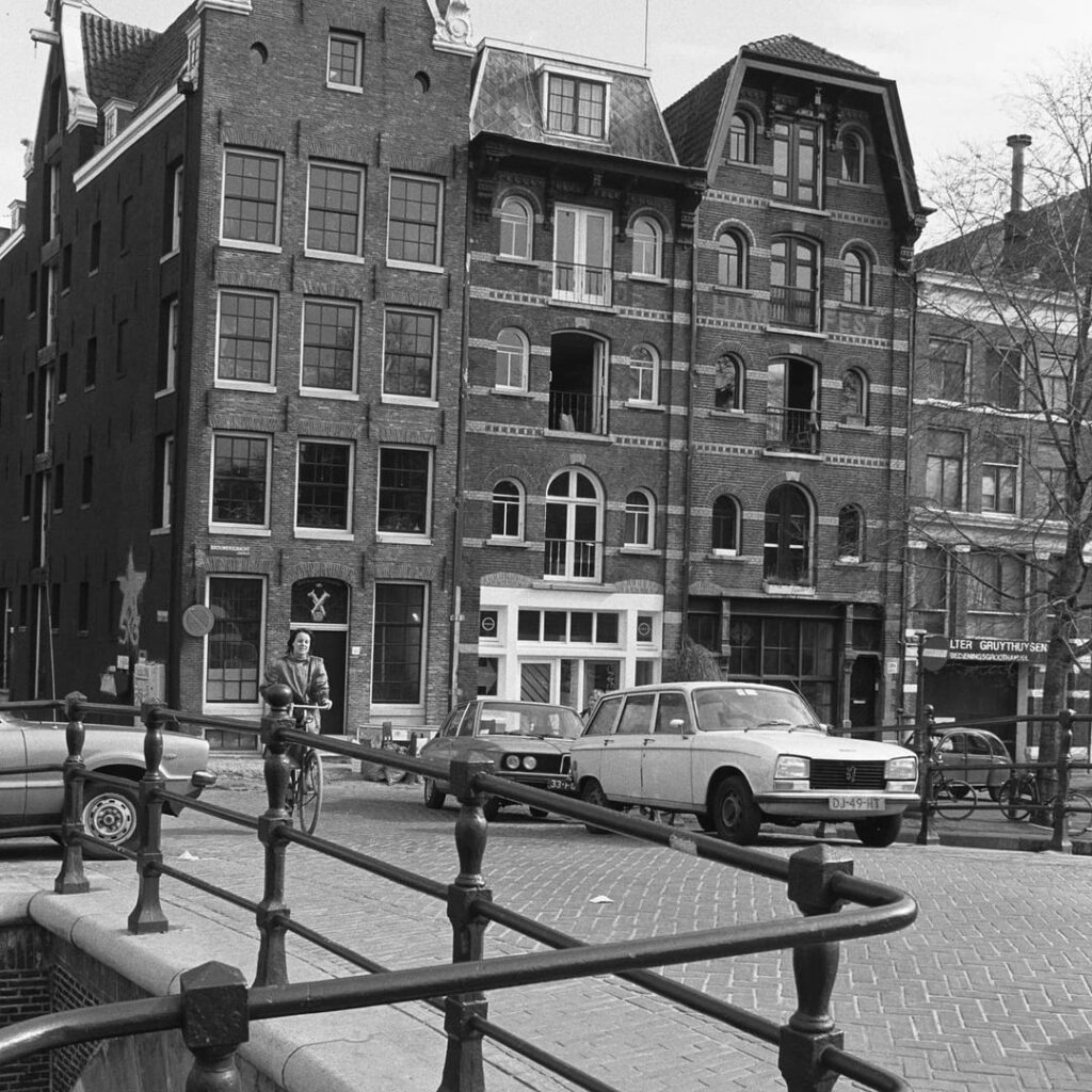
2. Brouwersgracht 156-162, facades seen from the Papiermolensluis. Gool, Han van 1981
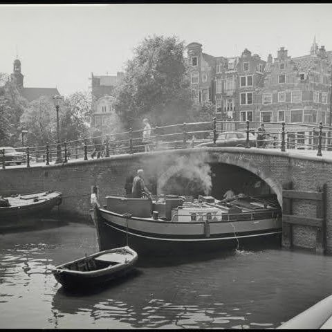
3. the Papiermolensluis, Brug 57. Puinschuit. Seen towards Singel, left Korte Prinsengracht Archief van de Dienst Ruimtelijke Ordening
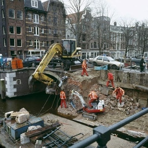
4. Work on the Paper Mill Lock. Photo from the series ‘For the time being’, commissioned by the Amsterdam Fund for the Arts. Buurman, Lard 2005
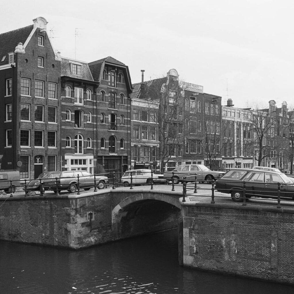
5. Brouwersgracht met Papiermolensluis (Brug 57) Archief van Dolf Toussaint1960 ca. t/m 1965 ca.
6. de Papiermolensluis (brug 57) Gool, Han van 1981
Technical Summary:
- Bridge number: 57
- Official name: Papiermolensluis (Paper Mill Lock)
- Historic nicknames: Brouwersluis, Oliekoekensluis
- Bridge type: Vaulted arch bridge (welfbrug), single span
- Primary materials: Brick and stone masonry (interior reinforced with concrete in 1991)
- Waterway crossed: Brouwersgracht
- Road carried: Connecting eastern quays of Prinsengracht and Korte Prinsengracht
- Date of stone construction: 1781 (per Frank V. Smit)
- Reinforcement dates: 1976, 1991
- Monument status: Gemeentelijk monument (Municipal monument) since 1995
- Coordinates: 52°22’33″N, 4°53’9″E
Citations and Archival Sources
- Smit, Frank V. Unpublished/published research on Amsterdam bridges (cited in Cramberts Bridges of Amsterdam research logs). Documents the placement of a stone bridge at this location in 1781.
- Van Berckenrode, Balthasar Florisz. Plattegrond van Amsterdam, 1625. Copperplate engraved map, nine sheets. Held at: Stadsarchief Amsterdam and Rijksmuseum, Amsterdam. The earliest cartographic representation suggesting a bridge crossing at this intersection.
- Blaeu, Joan. Afbeelding van Amsterdam, 1662. Printed map. Shows three bridges drawn at the Brouwersgracht and Prinsengracht intersection, confirming the fully developed state of the neighbourhood by mid-century.
- MforAmsterdam Tours. “Brouwersgracht.” mforamsterdam.com. Notes the 1647 map identification of the bridge as Brouwers Sluys and its function as a water-level lock. https://mforamsterdam.com/brouwersgracht/
- Cramberts Bridges of Amsterdam (Iain Croll). “Papiermolensluis, Bridge 57: Amsterdam,” “History and Information,” and “Map and Location,” published 5 April 2022, updated October 2023. https://bridges.cramberts.com/2022/04/05/papiermolensluis-bridge-57-amsterdam/ and associated pages. Primary synthesis of available archival material.
- Bruggen van Amsterdam (bruggenvanamsterdam.nl). “Korte Prinsengracht hoek Brouwersgracht.” Dutch-language registry entry confirming the name etymology from the “De Papiermolen” trade sign and the alternative nickname Oliekoekensluis. https://www.bruggenvanamsterdam.nl/korte_prinsengracht_hoek_brouwer.htm
- Stadsarchief Amsterdam, Beeldbank. Archival photograph collections:
- Collectie Bernard F. Eilers, 1916-1918 (winter snow photograph of the bridge).
- Archief van Dolf Toussaint, ca. 1960-1965 (Brouwersgracht view with Brug 57).
- Archief van de Dienst Ruimtelijke Ordening (urban planning service photographs).
- Buurman, Lard, 2005 (photographic series “For the time being,” Amsterdam Fund for the Arts). Access via: https://archief.amsterdam/beeldbank/
- Wikidata. Q15880471 (Papiermolensluis). Confirms bridge coordinates (52°22’33″N, 4°53’9″E), catalogue code 57, waterway crossed (Brouwersgracht), and monument category. https://www.wikidata.org/wiki/Q15880471
- Wikimedia Commons. Category: Brug 57, Papiermolensluis. Repository of 32 freely licensed images including historic and contemporary photographs. https://commons.wikimedia.org/wiki/Category:Brug_57,_Papiermolensluis
- Gemeente Amsterdam, Monumentenregister. Municipal monument register recording the 1995 designation of the Papiermolensluis (Brug 57) as a gemeentelijk monument. Consult via: https://www.amsterdam.nl/stadsarchief/ or the Monumenten en Archeologie department.
- That Dam Guide. “Top 5 Amsterdam Views.” Describes photographic conditions and confirms the bridge’s position as a primary visitor vantage point toward the Prinsengracht and Westertoren. https://thatdamguide.com/top-5-amsterdam-views/
- I Becoming Dutch. “23 Things Along the Prinsengracht.” Contextualises the bridge within the broader Prinsengracht corridor, including proximity to Café Papeneiland (1642), the Noorderkerk, and the Westerkerk. https://ibecomingdutch.wordpress.com/2020/10/18/22-things-along-the-prinsengracht/