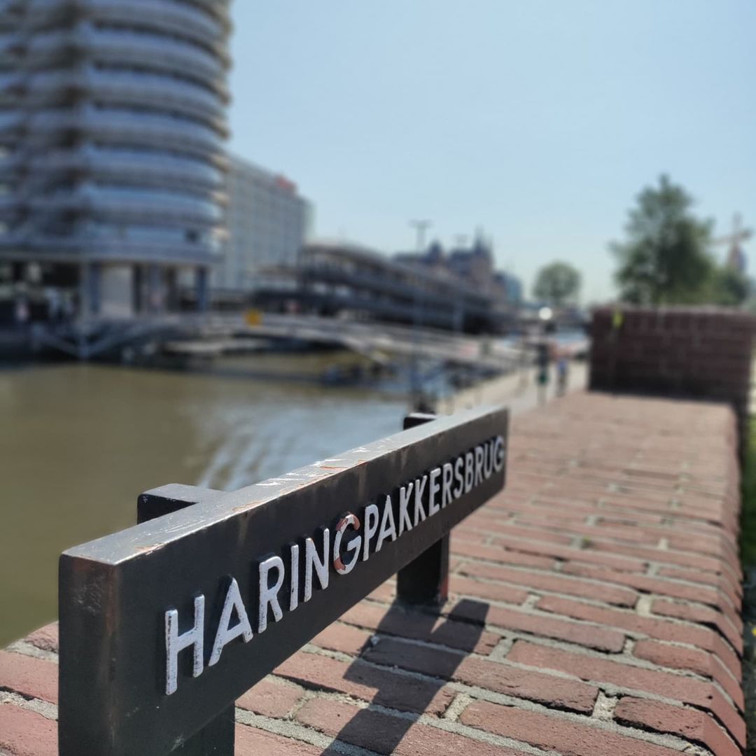
The Haringpakkersbrug, Bridge 58, carries the Prins Hendrikkade across the Singel at the point where it flows into the Open Havenfront. It’s a bridge with two distinct identities: a name rooted in seventeenth-century herring processing and a twentieth-century structure that ended up far wider than the traffic it was ultimately built to carry.
#brug58 The Haringpakkersbrug is a road bridge in Amsterdam-Centrum that is named after the Haring Pakkerye that was once located here. This also was the reason for the naming of the Haringpakkerstoren (an old fortification tower on the corner of the Singel and the current Prins Hendrikkade and now better known for the Silver Tower office building to the east of Central station) and the Haringpakkerssteeg both of which were demolished in 1829.
The part of the present-day Prins Hendrikkade at this corner was called Haringpakkerij, because the herring packers salted, boiled and packaged herring here as Singel flowed directly into the Ij.
Striking about the bridge are the balustrades between the brick bastions of the bridge. Like Piet Kramer, Dirk Sterenberg often made total concepts (see also #bridge13 ). On one of the abutments, letters depicting “Coming back is not the same as staying”, a 2006 artwork by Regina Verhagen with a line by Belle van Zuylen from her letter to David-Louis Constant d’Hermenches; the letters are executed in terrazzo. In the run-up to the bicycle tunnel, a kind of gable stone can still be seen with a statement about Amsterdam Level.
Also striking is the size of the bridge it is clearly too wide for the traffic flow here and the old tram lines over the bridge (part of why it was so wide) were never used and are being removed. This was in part due to the car being dominant at the time of its planning. See the history and information post for more on this.


1. Etymology and Naming: A Bridge Named for Herring Packers
The Haringpakkersbrug takes its name from the Haring Pakkerye (herring-packing works) once located on this stretch of what is now the Prins Hendrikkade, where herring was salted, boiled and packaged as the Singel flowed directly into the IJ. The same industry gave its name to two other features long since gone: the Haringpakkerstoren, a fortification tower that stood northwest of the bridge’s current location and the Haringpakkerssteeg, both demolished in 1829.
2. Structural Evolution: Three Centuries Without a Bridge, Then One Built for a Road That Never Arrived
Despite the Singel being one of Amsterdam’s oldest canals, there was no permanent bridge at this specific crossing for most of its history. For centuries, the Haarlemmersluis (Bridge 16) was the only structure separating the Singel from the IJ, meaning traffic travelling along the Prins Hendrikkade, or its predecessor, the Texel Quay, had to detour into the city just to cross the Singel, a routing still visible on Frederik de Wit’s map of 1688.
The first bridge actually at this spot didn’t appear until the 1880s and even then it was temporary: a wooden tram bridge, photographed by Pieter Oosterhuis around 1887 with Amsterdam Centraal still under construction in the background. That bridge was demolished in 1892/1893 and traffic reverted to detouring via the Haarlemmersluis once again, the site went back to being bridgeless for decades.
The bridge standing today is a product of mid-twentieth-century traffic planning rather than any continuous crossing history. In 1931, the city drew up a plan for radial roads connecting the centre to its outskirts, rerouting the westward road to Haarlem away from the Haarlemmerdijk and Haarlemmerstraat and onto the Haarlemmer Houttuinen instead, a project large enough to require demolishing roughly 1,200 homes and 275 business premises and relocating roads. Trams left the Haarlemmerstraat in 1955, replaced by a bus line, one of the first visible signs the plan was moving ahead.
The municipality returned to the question in 1965 and again in 1968, eventually asking the Dienst der Publieke Werken (Public Works Department) to design a bridge. Dirk Sterenberg, the city’s bridges architect at the time, produced the design and contractors began construction in April 1971. Quay walls and banks had to be raised as part of the work and a grade-separated cycle path was built beneath the bridge. By January 1972 the bridge itself was largely complete, though the surrounding area still needed extensive work, sewers, cables and other utilities had to be renewed and relocated, turning the site into a vast construction pit. The nearby Droogbak building (see below) was seen as an obstacle to the works but was, in the end, left standing.
Here’s the part that gives the bridge its defining quirk: it was built to a width matching a planned four-lane road with a tram line. Revised thinking later shrank the road to two lanes and the tram rails laid down in 1985 were never used. Traffic was instead rerouted around the Droogbak building via an S-curve reminiscent of the route trams had taken past the same building in the 1880s. The bridge remains, by design history rather than accident, conspicuously oversized for the traffic it now carries, the unused tram rails still run from the west up to the bridge, vanishing under the asphalt of the raised bus lane on the deck itself.
3. Architectural Lineage: Dirk Sterenberg’s Total-Concept Bridge
The bridge was designed by Dirk Sterenberg, Amsterdam’s city bridges architect at the time, built in reinforced concrete. The balustrades set between the bridge’s brick bastions are thought to also be his work: like Piet Kramer before him, Sterenberg frequently treated a bridge as a single, total design concept rather than a purely structural exercise, Bridge 13 is cited as a comparable example of that approach.
A 2006 artwork on one of the bridge’s abutments spells out, in terrazzo lettering, “Terugkomen is niet hetzelfde als blijven” (“Coming back is not the same as staying”), a line taken from a letter the eighteenth-century writer Belle van Zuylen sent to David-Louis Constant d’Hermenches. The artwork is by Regina Verhagen. Near the approach to the bicycle underpass on the bridge’s south side, a small marker also references Amsterdams Peil, the historic Amsterdam Ordnance Datum used as the country’s sea-level height reference.
4. Urban and Social Context: A Junction of Water, Rail and an Unbuilt Tram Line
The bridge sits at the point where the Singel flows into the Open Havenfront via a short stretch known as the Westertoegang (Western Access). It shares its southern quay walls with the Haarlemmersluis (Bridge 16) and its northeastern quay wall merges into that of the adjacent cyclists’ bridge, Bridge 387. Just under 100 metres to the north stands the large railway bridge that Dutch Wikipedia identifies as Bridge 19s.
The bridge connects directly with Droogbak, former site of the Gebouw Droogbak, also known as the HIJS-gebouw after the Hollandsche IJzeren Spoorweg-Maatschappij (Holland Iron Railway Company), in front of which the Amsterdamsche Omnibus Maatschappij once operated a tram depot, the Remise Droogbak, visible in Oosterhuis’s 1887 photograph alongside the Centraal Station construction site.
The bridge’s oversized proportions are, in effect, a small piece of accidental social history: built for a four-lane road and tram line that never materialised, it stands today as physical evidence of a traffic vision that didn’t survive contact with later urban planning priorities.
Brug 58/Haringpakkersbrug map and location
///tornado.desire.craft
This road bridge is located in the Prins Hendrikkade and spans the Singel. It marks the place where the Singel flows into the Open Havenfront (Open Harbour front), here it is a short canal called Westertoegang (Western Access). The bridge shares its southern quay walls with the Haarlemmersluis (#bridge16) and its northeastern quay wall merges into that of the cyclists’ #bridge387 Then less than 100 meters north you will find the very wide railway bridge (not sure if these are numbered) and then at the entrance to the Ij another multi-use bridge Westertoegang #Brug147


Haringpakkersbrug/Bridge 58 information and history
The Singel is one of the oldest canals in Amsterdam so you would expect that a bridge over the Singel is centuries old right? Wrong. Nothing could be further from the truth. For centuries the Haarlemmersluis #brug16 was the bridge that separated the Singel from the IJ. Traffic passing over the Prins Hendrikkade or its predecessor, the Texel Quay had to enter the city to cross the Singel, as can be seen on Frederik de Wit’s map from 1688.
Photographer Pieter Oosterhuis documented a wooden tram bridge here around 1887 so there was definitely a bridge here then.
In 1931 a plan was made for radial roads from Amsterdam-Centrum to the outskirts. The route west to Haarlem would then no longer run via the Haarlemmerdijk and Haarlemmerstraat but instead via the Haarlemmer Houttuinen. The trams left the Haarlemmerstraat in 1955 when a bus line was introduced. In 1965 and again in 1968, the municipality discussed the plan and the Public Works Department was asked to come up with the design of a bridge. Dirk Sterenberg, the then city bridges architect, created a design and in April 1971 the contractors began construction. The Haringpakkersbrug was given a width that connected with the planned four-lane road with a tram track. New insights led to a reduced two-lane road and the tram rails laid down in 1985 were never used.


Photos from the archive and Wikipedia
1. Pieter Oosterhuis’s tram bridge with the Central Station under construction in the background c: 1887
2. Artwork under the Haringspakkersbrug in Amsterdam. The text reads: “Coming back is not the same as staying”. The letters made of red plastic are used by the passengers of passing party boats to store empty champagne bottles. (Wikipedia: Milliped) August 9, 2017
3. Plaque at the bicycle underpass on the south side of the Haringspakkersbrug. The text is “Zynde nine feet and five feet above city level” (Wikipedia: Milliped) August 9, 2017
4. Bridge from above Collectie Bureau Monumentenzorg
1953 ca. t/m 1995 ca.
5. The predecessor of the Haringpakkersbrug as a separation between the Singel and the Open Havenfront Atelier Herz 1884
6. Brug 58 Martin Alberts 13
5. Technical Specifications
Based on confirmed sources, the following can be stated:
- Bridge type: Fixed bridge, reinforced concrete
- Location: Prins Hendrikkade, spanning the Singel at its junction with the Open Havenfront (Westertoegang), Amsterdam-Centrum
- Coordinates: 52°22′46.29″N, 4°53′42.07″E (Wikidata Q38554870)
- Clearance height: 2.93 m
- Clearance width: 12.00 m
- Construction period: 1971–1972 (design by Dirk Sterenberg for the Dienst der Publieke Werken; construction began April 1971, largely complete by January 1972)
- Predecessor structure: A wooden tram bridge, in place by 1887, demolished 1892/1893
- Material: Concrete
- Notable features: Balustrades between brick bastions (attributed to Sterenberg); 2006 terrazzo artwork by Regina Verhagen quoting Belle van Zuylen; Amsterdams Peil reference marker near the cycle underpass; unused 1985 tram rails embedded beneath the road surface
- Etymology: Named after the Haring Pakkerye (herring-packing works) once on this site; also the source of the names of the demolished (1829) Haringpakkerstoren and Haringpakkerssteeg
- Adjacent/connecting structures: Shares quay walls with the Haarlemmersluis (Bridge 16); adjoins cyclists’ Bridge 387; connects with Droogbak; railway Bridge 19s stands just under 100 m north
- Wikidata: Q38554870
Sources Consulted
- Wikipedia (nl), “Haringpakkersbrug”
- Wikidata, “Haringpakkersbrug” (Q38554870)
- Wikimedia Commons, Category: Brug 58, Haringpakkersbrug
- Frank V. Smit, “Bruggen in Amsterdam,” 2008, Uitgeverij Matrijs (cited in Wikipedia nl)
- Algemeen Handelsblad, 21 July 1965 (cited in Wikipedia nl)
- De Waarheid, 9 April 1971 (cited in Wikipedia nl)