
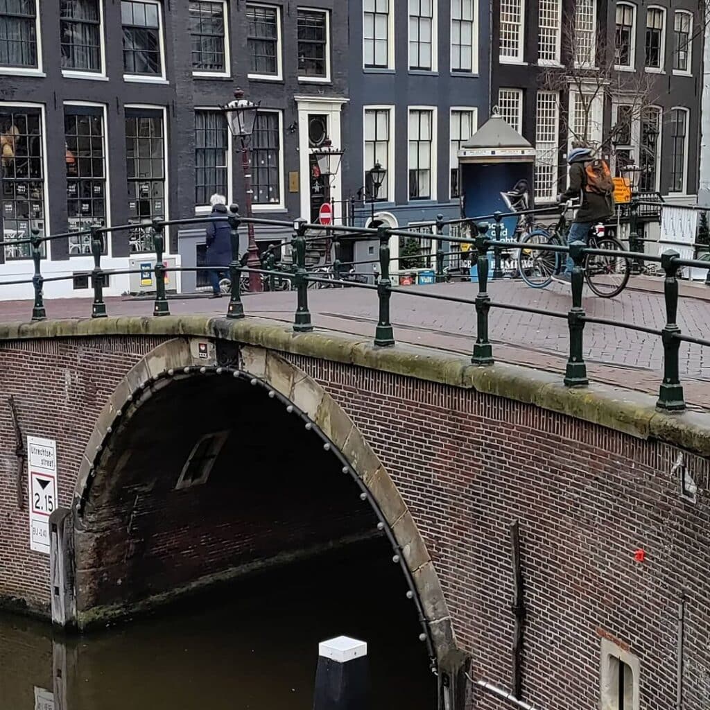
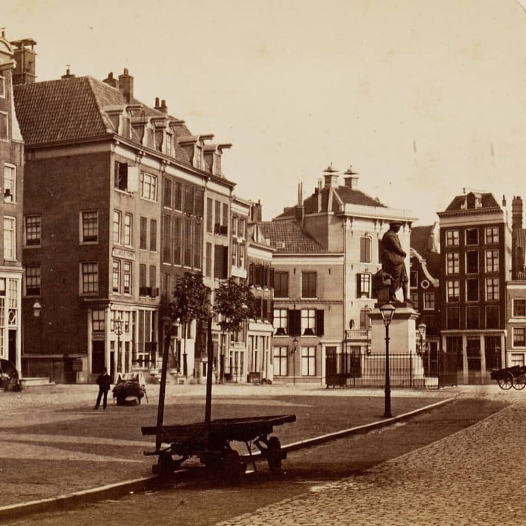
The Bridge of 15 bridges (Brug van 15 bruggen). This viewpoint is named the 15 bridges because standing on the odd-numbered side with your back to Thorbeckeplein you can see 6 arched bridges across the Reguliersgracht. Look down Herengracht to the left and you see another 6 bridges. Furthermore, two more bridges are visible to your right over Herengracht. Finally, the 15th bridge is the one you’re standing on.
The bridge is named after the cheese market that was held on Reguliersplein, later renamed Thorbeckeplein close to the Rembrandtplein also historically the butter market.
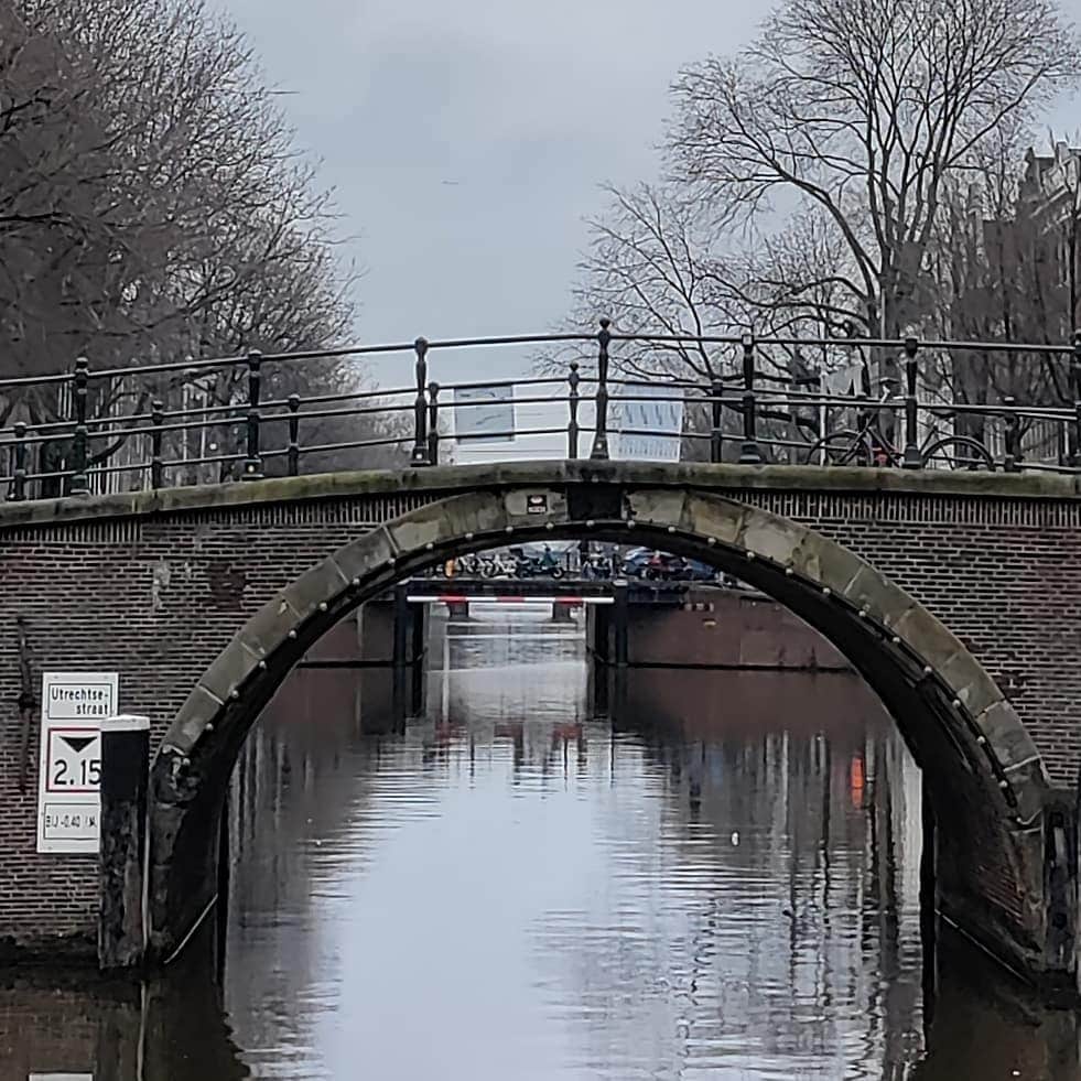
It spans the Herengracht at an angle of 90 degrees, the south-eastern shore side seamlessly merges with that of the Tante Saarbrug (bridge 31). In that joint quay wall a foundation stone with “Anno 1734” on it. It is striking that the bridge has only one passage as most bridges over the “large” canals have multiple passageways. A wider passage was not necessary on this bridge because bridge 34 further along is also so narrow.
The bridge was almost removed in 1907 as there was a plan to create a direct connection between Rembrandtplein and Ferdinand Bolstraat. The Reguliersgracht would be filled in to create this. However it was decided to widen the Vijzelstraat instead. In part his choice came about because of the beauty of the Herengracht section here.

A Rare Single-Span Arch Bridge on the Eastern Quay of the Reguliersgracht
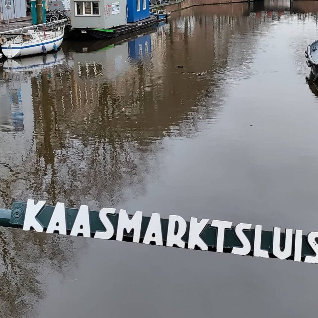
There is a particular type of Amsterdam bridge name that works like a time capsule. The Kaasmarktsluis, Bridge 32, carries one of the most vivid of them: the memory of a cheese market that was swept away by a municipal gentrification campaign in 1876, leaving behind nothing but a renamed square and a bridge whose name has outlasted the market, the stalls, the farmers, and the redevelopment effort by a century and a half. The bridge itself also has something unusual to offer in purely structural terms: in a city where the great Herengracht crossings almost all have three or more spans, the Kaasmarktsluis spans the canal with a single arch, a design that makes it one of the most distinctive crossings in this entire series.
1. Etymology and Naming: Cheese, Butter, and the Renaming of Two Squares at Once
The bridge is named after the cheese market that was once held on the Thorbeckeplein. That single sentence requires considerable unpacking, because the Thorbeckeplein itself was not always the Thorbeckeplein, and the cheese market it once hosted was part of a wider dairy and food trading district that has entirely vanished from the physical landscape while leaving its name preserved in stone.
The square beside the bridge has carried several names across its history. The Thorbeckeplein was created by the filling in of a section of the Reguliersgracht in 1785, and initially received the name Reguliersplein. It was subsequently renamed the Kaasmarkt, reflecting the cheese market held there. The adjacent square, where butter was traded, was known as the Botermarkt. Both names described a working commercial reality: the intersection of the Herengracht with the Reguliersgracht, and the streets leading from it toward the Rembrandtplein, formed one of the busiest dairy trading areas in the inner city.
The transformation came in a single municipal council decision. At a council meeting of 17 May 1876, the municipality voted to rename the Reguliersplein as the Thorbeckeplein, honouring the statesman Johan Rudolph Thorbecke who had played a central role in drafting the Dutch constitution of 1848. The adjacent Botermarkt was simultaneously renamed as the Rembrandtplein.
The cheese market and butter market were abolished as part of this campaign of late-19th-century gentrification. Some users of the Botermarkt complained at the time about the loss of commercial space, but it did not prevent the placing of the Rembrandt statue in the butter market or the placing of the Thorbecke statue in the cheese market. Both squares were intended to attract more civilised user groups, and passers-by were meant to be stimulated to look at the statues of Rembrandt and Thorbecke.
The bridge itself had no part in this decision. Its name, the Kaasmarktsluis, was already in use before 1876 to describe the crossing adjacent to the cheese market. An unofficial shorter form, Kaassluis, meaning simply Cheese Lock, is also in circulation and is how most Amsterdammers refer to the bridge in daily conversation. As with several bridges in this series, the word “sluis” here does not mean a hydraulic lock but a stone bridge, the older Dutch usage of the term preserved in the bridge’s formal name.
The statue of Thorbecke that now stands at the south end of the square was the work of sculptor Ferdinand Leenhoff and was erected in 1876 at the moment of the renaming. The bronze figure stands upon a tall rectangular pedestal, and from the vantage point of the statue there are views directly down the Herengracht and along the line of the Reguliersgracht bridges. The bridge and the statue face each other across a corner that has been continuously occupied since the late 17th century.
2. Structural Evolution: Planned on Stalpaert’s Map of 1662, Present on de Wit’s Map of 1688, with an Anno Stone of 1734
The documentary record for Bridge 32 is among the richest and most precisely sourced of any bridge in this series. There has been a bridge at this location for centuries. City architect Daniël Stalpaert drew a bridge here on the design section of his map of 1662, though the surrounding area still required substantial development, as indicated by a map produced for the land issue of May 1664. Jacob Bosch also recorded the bridge on his plan of the Fourth Explanation. Frederik de Wit’s map from 1688 shows a developed neighbourhood with the bridge once again present.
The sequence Stalpaert (1662), land issue map (1664), Bosch, and de Wit (1688) traces the bridge from a planned structure in an undeveloped area to a working crossing in an inhabited district, all within a single generation of the canal ring’s construction. This is unusually precise cartographic evidence for a bridge of this age.
There is a physical date marker still visible on the bridge today. In the shared quay wall where the southeastern walkway of Bridge 32 meets that of the Tante Saarbrug (Bridge 31), a stone has been placed bearing the inscription “Anno 1734.” This stone is the most direct material evidence of an 18th-century construction or reconstruction date for the bridge, placing it in the same generation as the nearby Vier Heemskinderenbrug (Bridge 28, dated to 1722) and the Beulingsluis (Bridge 27).
The bridge also has a documented near-miss with demolition. In 1907, there was a plan to create a direct connection between the Rembrandtplein and the Ferdinand Bolstraat, which would have required the infilling of the Reguliersgracht. The municipality chose a different variant, specifically the widening of the Vijzelstraat. That decision was influenced in part by the fact that building a new bridge here would have been costly precisely because of the beauty of this section of the Herengracht. The aesthetic quality of the setting, in other words, is part of what saved the canal and the bridge from elimination.
A more unusual event punctuated the bridge’s otherwise uneventful structural history. In 1935, the high arch of the bridge was the subject of discussion again following a horse tragedy. A coachman with a loaded cart carrying coffee and tea attempted to descend from the bridge onto the Herengracht quay. The horse lost its grip on the road and slid with the cart into the flower cellar at Reguliersgracht 1. The horse fell so badly that, despite several rescue attempts, she died. There was no discussion of lowering the bridge to prevent this type of accident. This anecdote, documented in the Dutch Wikipedia article on the Kaasmarktsluis and dated to 2017 as still accurate, confirms that the bridge’s arch profile was never subjected to the flattening that transformed so many of the other Herengracht crossings in the late 19th and early 20th centuries. Bridge 32 retained its high profile because the decision to widen the Vijzelstraat rather than fill in the Reguliersgracht meant the immediate pressure for a tram-compatible flat crossing was never applied here.
3. Architectural Lineage: A Single-Arch Bridge Surrounded by Rijksmonumenten, Itself Not Listed
The Kaasmarktsluis is structurally defined by one feature that sets it apart from every other bridge encountered in this series so far: it has only a single navigation opening. The bridge has only one passage opening. A wider opening was not necessary because Bridge 34, further along the canal, is also narrow. This is a practical observation with an aesthetic consequence: the single arch gives Bridge 32 a more concentrated, monumental quality than the three-span bridges on the Herengracht to its north. The single arch rises and descends in one unbroken curve, crossing the full width of the canal in one statement rather than dividing it into three.
No individual architect is confirmed for the current structure in any source consulted for this post, and the bridge is attributed in the available records to the Dienst der Publieke Werken. The bridge predates the Amsterdam School movement entirely.
The bridge itself is not a monument, though it is surrounded by Rijksmonumenten, including the statue of Johan Rudolph Thorbecke. This is a characteristic shared with Bridge 24 earlier in this series: the Kaasmarktsluis sits at the centre of one of the most protected urban landscapes in the Netherlands, within a UNESCO World Heritage canal belt, yet does not carry its own formal heritage designation. The canal houses on both banks, the Thorbecke statue, and the Reguliersgracht alignment of bridges are all protected; the bridge connecting them is not. Whether that distinction reflects a considered heritage judgement or simply an administrative anomaly is a question the sources do not resolve.
4. Urban and Social Context: The Bridge of Fifteen Bridges, the Seven-Bridge View, and the Corrected Geography
Bridge 32 sits at the most discussed canal intersection in Amsterdam in terms of bridge geometry, and that geometry requires careful handling because it has been significantly misrepresented in popular travel literature.
The bridge spans the Herengracht, connecting the Thorbeckeplein with the Reguliersgracht. It has earned the nickname the Bridge of Fifteen Bridges. From the bridge, standing with your back to the Thorbeckeplein, you can see six arched bridges along the Reguliersgracht. Looking down the Herengracht to the left, you see another six bridges. Two more bridges are visible to the right along the Herengracht. The fifteenth bridge is the one you are standing on.
Some travel guides and tourist information websites refer to this bridge as the Bridge of Fifteen Bridges, and some say that Bridge 32 is itself the fifteenth bridge. However, if you stand on the Kaassluis you will still not be able to see all seven bridges across the Reguliersgracht. The line of sight does not allow for it, and the trees along the canal block the view. The geometrically correct “Bridge of Fifteen Bridges” viewpoint is in fact the pavement at the northeast corner of the Herengracht and the Reguliersgracht, on the Tante Saarbrug (Bridge 31), a few metres to the west of Bridge 32, from which the canal boat tourists enjoy their famous view of the Reguliersgracht alignment from water level.
The distinction matters for readers who visit expecting a magical fifteen-bridge panorama from the deck of Bridge 32 itself. The view from the bridge is nonetheless extraordinary. When you stand on the bridge with your back to the Thorbeckeplein, you see the arches of the six bridges crossing the Reguliersgracht from a unique perspective. The view is almost magical at night, when a host of bulbs illuminates the arches to create what has become known as the tunnel of love.
The immediate neighbourhood around Bridge 32 is also among the most historically layered in the canal belt. The Willet-Holthuysen Museum at Herengracht 605, a 17th-century canal mansion left to the city in 1895 with its interior intact, is a five-minute walk along the Herengracht. On the right side under the bridge, one has one of the most photographed views in Amsterdam: the famous seven bridges of the Reguliersgracht. At night all these bridges are illuminated. The Reguliersgracht is considered to be one of the most beautiful canals of Amsterdam. The Art Deco Tuschinski cinema is a three-minute walk along the Reguliersdwarsstraat, and the Rembrandtplein nightlife district is immediately around the corner.
5. Technical Specifications
Based on confirmed sources, the following can be stated:
- Bridge type: Fixed single-span arch bridge (vaste eenoverspanning welfbrug)
- Location: Eastern quay of the Reguliersgracht, spanning the Herengracht, Amsterdam-Centrum; connects the Reguliersgracht with the Thorbeckeplein
- Canal crossed: Herengracht (UNESCO World Heritage Canal Belt, listed 2010)
- Navigation openings: One (single arch), unusually narrow for the Herengracht; coordinated with the also narrow Bridge 34 further along the canal
- Cartographic record: Daniël Stalpaert map, 1662 (planned); land issue map, May 1664; Jacob Bosch plan of the Fourth Explanation; Frederik de Wit map, 1688 (completed bridge in developed neighbourhood)
- Anno stone: “Anno 1734,” visible in the shared quay wall with Bridge 31 (Tante Saarbrug) at the southeastern corner
- Designer: Dienst der Publieke Werken; no individual architect confirmed
- Amsterdam School attribution: None; the bridge predates the movement
- Threatened with demolition: 1907 plan to fill in the Reguliersgracht abandoned in favour of widening the Vijzelstraat; the bridge’s aesthetic setting was cited as a factor in that decision
- Monument status: Not a monument (geen monument); the bridge is surrounded by Rijksmonumenten including the Thorbecke statue
- Nickname: Kaassluis (Cheese Lock), the shorter informal name in everyday use
- Notable feature: Single-span arch; Anno 1734 stone in the shared quay wall with Bridge 31; position at the canal intersection from which the Reguliersgracht’s seven-bridge alignment is most closely approached
Sources Consulted
- Bruggenvanamsterdam.nl, bridge register entry for Brug 32: www.bruggenvanamsterdam.nl/herengracht_hoek_thorbeckeplein.htm
- Wikipedia (nl), “Kaasmarktsluis”: nl.wikipedia.org/wiki/Kaasmarktsluis
- Bridges.cramberts.com, “Kaasmarktsluis, Bridge 32, History and information”: bridges.cramberts.com/amsterdam/history/kaasmarktsluis-bridge-32-history-and-information/
- Bridges.cramberts.com, “Kaasmarktsluis, Bridge 32, Map and location”: bridges.cramberts.com/2022/04/03/kaasmarktsluis-bridge-32-map-and-location/
- Wikipedia (nl), “Thorbeckeplein”: nl.wikipedia.org/wiki/Thorbeckeplein
- Wikipedia (en), “Rembrandtplein”: en.wikipedia.org/wiki/Rembrandtplein
- Amsterdam op de kaart, “Thorbeckemonument, Thorbeckeplein”: amsterdamopdekaart.nl/1850-1940/Thorbeckeplein/Thorbeckemonument
- Joodsamsterdam.nl, “Thorbeckeplein”: www.joodsamsterdam.nl/thorbeckeplein/
- DutchAmsterdam.nl, “Fact Check: Can you really see 15 of Amsterdam’s bridges at this spot?”: www.dutchamsterdam.nl/67-bridges-of-amsterdam
- Play and Tour Amsterdam audioguide, “Reguliersgracht”: www.playandtour.com/audioguides/amsterdam-en/reguliersgracht
- Bridges.cramberts.com, “Bridge 73”: bridges.cramberts.com/2026/03/09/bridge-73-amsterdam/ (for Reguliersgracht bridge series context)
- Amsterdam.info, “Herengracht”: www.amsterdam.info/herengracht/
- Wikimedia Commons, Category: Brug 32, Kaasmarktsluis: commons.wikimedia.org/wiki/Category:Brug_32,_Kaasmarktsluis
Public Domain Images

1. “Brug 32, Kaasmarktsluis foto 1.JPG,” Wikimedia Commons A direct photograph of Bridge 32 showing the single-arch span over the Herengracht, with the Reguliersgracht visible in the background. Available in the Wikimedia Commons category for the bridge and confirmed as existing at the URL below. URL: https://commons.wikimedia.org/wiki/File:Brug_32,_Kaasmarktsluis_foto_1.JPG Attribution: “Wikimedia Commons, File: Brug 32, Kaasmarktsluis foto 1.JPG. Available under the licence specified on the file’s description page.”

2. Wikimedia Commons category overview images, Brug 32 The broader Wikimedia Commons category for Bridge 32 holds additional photographs showing the bridge from different angles, including canal-level views that show its relationship with the Reguliersgracht seven-bridge alignment to the south. URL: https://commons.wikimedia.org/wiki/Category:Brug_32,_Kaasmarktsluis Attribution: “Wikimedia Commons, Category: Brug 32, Kaasmarktsluis. Available under the licences specified on individual file description pages.”

3. Stadsarchief Amsterdam Beeldbank: historical photographs of the Kaasmarkt and Reguliersplein area The Stadsarchief Amsterdam holds archival photographs of the Thorbeckeplein and adjacent Reguliersgracht from the late 19th and early 20th centuries, including images that show the pre-gentrification market context in which Bridge 32 sat. Searchable via the Beeldbank at archief.amsterdam under terms including “Reguliersplein,” “Kaasmarkt,” and “Herengracht Reguliersgracht.” URL: https://archief.amsterdam/beeldbank Attribution: “Collectie Stadsarchief Amsterdam. Available for non-commercial use with attribution.”
Map and location of Bridge 32 Kaasmarktsluis
Spanning the Herengracht and connecting the Thorbeckplein with the Reguliersgracht, this bridge holds a special place and offers a unique view in Amsterdam, earning its nickname, the Bridge of 15 bridges (Brug van 15 bruggen). The name “15 bridges” comes from the fact that when standing on this bridge with your back to Thorbeckeplein, you can see six arched bridges along the Reguliersgracht. Additionally, if you look down Herengracht to the left, you’ll spot another six bridges, while two more bridges can be seen to your right along the Herengracht. Therefore, the 15th bridge is the very one you are standing on. City architect Daniël Stalpaert had already envisioned a bridge at this location in his 1662 map. However, the area still required substantial development, as indicated by a map created for the land issue of May 1664. Jacob Bosch also depicted the bridge in his plan of the Fourth Explanation. Furthermore, Frederick de Wit’s 1688 map revealed a fully equipped neighborhood, complete with an additional bridge in this vicinity.


The Six Bridges (Zes Bruggen) on Reguliersgracht in Amsterdam are a series of picturesque and iconic bridges that span the canal. Reguliersgracht is one of the most charming canals in the city, known for its unique shape, with seven bridges in close proximity forming the distinctive crescent curve.
Location: Reguliersgracht is located in the historic center of Amsterdam, within the canal belt. The canal runs between the Herengracht and Prinsengracht, parallel to the Keizersgracht.
Architectural Design: The Six Bridges are renowned for their classic Dutch architectural design. They are typical low arched bridges with brickwork, stone railings, and ornate details, which are characteristic of Amsterdam’s canal bridges from the 17th and 18th centuries.
Scenic Beauty: The area around the Six Bridges on Reguliersgracht offers stunning views and is a favorite spot for both locals and visitors to take leisurely walks, cycle, or enjoy a boat tour along the canal.
Photography and Sightseeing: The series of bridges on Reguliersgracht is a popular subject for photographers and a must-see attraction for tourists exploring Amsterdam’s canal belt. The picturesque setting with the bridges and the canal makes it a postcard-perfect scene.
Historical Significance: The bridges on Reguliersgracht are not only beautiful landmarks but also hold historical significance as part of Amsterdam’s rich heritage. The city’s canal belt, including Reguliersgracht and its bridges, is a UNESCO World Heritage site.
Vibrant Neighborhood: The area around Reguliersgracht is known for its lively atmosphere with numerous cafes, restaurants, and boutique shops. It attracts both locals and tourists, making it a vibrant and sought-after neighborhood in Amsterdam.
Accessibility: The Six Bridges on Reguliersgracht are easily accessible, and you can explore them on foot or by bike while taking in the charming ambiance of the canal belt.
History and information about brigde 32 Kaasmarktsluis
The bridge is named after the local cheese market. Although the cheese market and butter market are no more after a campaign of gentrification in the late 1800’s, the bridges and nearby streets somehow kept their names.
Some users of the Botermarkt complained at the time about the loss of
commercial space but it did not prevent the placing of the Rembrandt statue in the butter market and the placing of the Thorbecke in the cheese market.
The claim of the Rembrandt statue on the popular Botermarkt only
expanded when the municipal authorities aimed to transform the square
into a more decent space, the authorities tried to influence popular behaviour and in 1876, the statue of the liberal statesman Thorbecke was erected a few hundred metres away from that of Rembrandt. This led to a large-scale renovation of the Botermarkt and the adjoining Kaasmarkt/Reguliersplein (‘Cheese Market’). Both squares were meant to attract more civilised user groups, and passers-by should be stimulated to look at the statues of Rembrandt and Thorbecke. One of the effects was that the location that had been used for commercial markets also then went through a rebranding exercise and this was reflected in street names. In 1876, the Botermarkt
was rechristened as Rembrandtplein (Rembrandt Square) simultaneously, the Reguliersplein was named after Thorbecke.
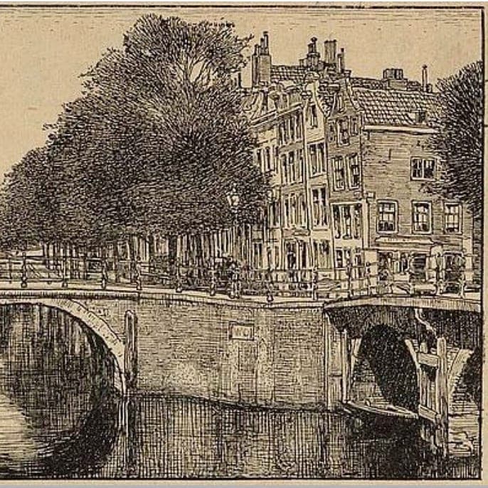
Picture 1 The Reguliersgracht was then, and still is, picturesque today
Picture 2 Thorbeckplein