
Bridge 14: The Haarlemmersluis
The Haarlemmersluis occupies a position that most Amsterdam bridges do not: it is both a bridge and a lock, a fixed road crossing and a working piece of water management infrastructure. Situated where the Singel meets the Open Havenfront, near the junction with the Brouwersgracht and the edge of the Haarlemmerdijk district, it marks the northwestern mouth of the canal ring. To cross it on foot or by bicycle is unremarkable; to understand what is happening beneath the road surface is to encounter four centuries of hydraulic engineering in continuous use.
The bridge carries the official designation Brug 14 and the name Haarlemmersluis. It is a rijksmonument, protected as a national monument under number 518342. The lock chambers, the keeper’s house, and the ironwork of the crossing together form an ensemble that the national heritage register treats as inseparable. The Haarlemmersluis is not simply a bridge that happens to sit over a lock: it is a single piece of infrastructure in which road and water management are structurally intertwined.
The Haarlem Road: A Name That Records a Trade Route
The name Haarlemmersluis does not record a landowner, a vanished market, or a demolished building. It records a journey. The Haarlemmertrekvaart, the barge canal connecting Amsterdam to Haarlem that opened in 1631, began its route at this precise point on the city’s northwestern edge. Ships departing Amsterdam for Haarlem, the textile and printing centre that supplied the canal ring with linen and published books, left the city through this lock. Ships arriving from Haarlem with goods, passengers, and correspondence entered the canal system here. The lock was, in effect, the city’s western gate for this specific corridor of commerce.
The trekschuit (horse-drawn barge) service on the Haarlemmertrekvaart was one of the most reliable scheduled transport connections in the Dutch Republic. Departures were timed, fares were regulated, and the fifteen-kilometre journey took three to four hours. For a significant period, this lock and the canal behind it handled a volume of scheduled passenger and cargo traffic that would be recognisable today as a form of public transport. The name Haarlemmersluis encodes all of this: not the structure itself but the destination it opened toward, and the commercial relationship between two cities that the journey sustained.
1602: The First Lock at the Edge of the City
The first recorded lock at this location dates to around 1602. The structure was wooden, as were most of Amsterdam’s locks and bridges during the period before the canal ring expansion. Its function was hydraulic rather than symbolic: the city needed to control the exchange between the brackish tidal water of the IJ and the fresher, more carefully managed water of the developing canal system. The Singel at this point was the outermost edge of the city’s defended perimeter, and the lock served both as a water regulator and as one of the control points in the chain that defined Amsterdam’s western boundary.
The 1602 date places the first lock within the period immediately preceding the great canal ring expansion of 1610 to 1665, which extended the city southward and westward and transformed the Singel from a defensive moat into the innermost canal of a much larger urban structure. The lock that existed in 1602 belonged to a more compact Amsterdam, one whose water boundaries were still actively maintained as military infrastructure alongside their hydraulic role. When the Haarlemmertrekvaart opened in 1631, it found its city terminus at a lock that already existed for quite different reasons, and the lock’s commercial function grew to overlay its original defensive one.
1681: The Stone Rebuilding
The wooden lock was replaced by a stone structure in 1681. This reconstruction was part of a broader programme of upgrading Amsterdam’s hydraulic infrastructure that occurred throughout the later seventeenth century, as the city’s prosperity and its engineering ambitions grew together. Stone locks were more durable, more precisely controllable, and more consistent in their management of water levels. They also projected a different kind of civic authority: a stone lock at the entrance to the Haarlemmertrekvaart announced to arriving travellers that they were entering a city that invested seriously in its own infrastructure.
The 1681 stone structure served the city through the height of its commercial power and into the long contraction of the eighteenth century, when Amsterdam’s global trade position declined relative to British and French competitors. Throughout this period, the lock continued its original function: regulating the water exchange between the IJ and the Singel, managing the entry and exit of barges on the Haarlemmertrekvaart, and contributing to the hydraulic balance of the canal network. The 1625 map by Balthasar Florisz. van Berckenrode, drawn before the stone rebuilding, shows the original configuration of the lock in its context at the city’s edge, providing a record of the structure that preceded the 1681 renewal.
Painters at the Water Gate: Storck, Van Kessel, and the Visual Record
The Haarlemmersluis appears in seventeenth and eighteenth century paintings and drawings that document Amsterdam’s maritime and commercial life. Artists including Abraham Storck and Jan van Kessel recorded the lock in works that now serve as visual documents of the waterfront before the nineteenth-century transformations. These images show the lock gates and their immediate surroundings in a period when the adjacent Haringpakkerstoren, the Herring Packers Tower, was still standing: a substantial structure that anchored the northwestern corner of the city’s harbour frontage and gave context to the lock’s position at the edge of the IJ.
The Haringpakkerstoren no longer exists. It was demolished in 1829, one of many towers and gateways that Amsterdam removed during the nineteenth century as the city modernised its street network and as the defensive logic that had justified these structures became redundant. Its absence from the present waterfront means that the paintings and drawings in which it appears alongside the Haarlemmersluis are among the few records of the old relationship between the lock and the surrounding harbour architecture. The Rijksmuseum collection holds works from this tradition that allow the current structure to be read against its historical visual context, in a period when the lock was a busy threshold rather than a water management instrument operating largely below the level of public attention.
1883: Reconstruction for the Railway Age
The significant reconstruction of 1883 was not undertaken for aesthetic reasons but for hydraulic ones. The construction of the Central Station on its artificial island in the IJ, begun in 1882, fundamentally altered the water management conditions at Amsterdam’s northern edge. The station’s island changed tidal patterns, affected water levels, and required a comprehensive reassessment of how the city’s lock and sluice infrastructure managed the relationship between the IJ and the canal network.
The 1883 reconstruction addressed these changed conditions by upgrading the lock chambers and adjusting sill levels and gate geometry to maintain the water management function under a hydraulic regime that the 1681 builders could not have anticipated. The bridge deck was also reconsidered as part of this work, adapting the crossing to the traffic patterns of a city beginning the early stages of transition to motorised and tram-based transport. This reconstruction marks the point at which the Haarlemmersluis was substantially reconceived as infrastructure for a modern city, rather than maintained as an updated version of the seventeenth-century original. The stone bones of 1681 gave way to a structure oriented toward the demands of the coming century.
Piet Kramer and 1927: The Amsterdam School at the Lock
The 1927 renovations brought Piet Kramer’s involvement to the Haarlemmersluis. Kramer, whose work defined the visual character of Amsterdam’s bridge stock across the 1910s and 1920s, was responsible for the ironwork and structural details of the renovation. The adjacent sluiswachterswoning, the lock keeper’s house, shows the characteristic vocabulary of the Amsterdam School: warm brick, geometric ironwork, and a compositional logic that treats the keeper’s house as an architectural element integrated with the lock structure rather than as a separate functional building placed nearby.
Kramer’s approach at the Haarlemmersluis was consistent with his work elsewhere in the city. He was not interested in treating bridge and lock furniture as purely utilitarian. The ironwork, the handrails, and the integration of structural and decorative elements were resolved in the language he had developed across more than two hundred bridges, giving the Amsterdam canal ring its characteristic interwar visual identity. The 1927 intervention at the Haarlemmersluis was not a comprehensive rebuild on the scale of the 1883 reconstruction; it was a precise refinement of the surface elements that gave the structure its public face.
The sluiswachterswoning is among the elements that the rijksmonument designation specifically protects. A lock keeper’s house at an active lock was an operational necessity: someone needed to be present to manage the gates, monitor water levels, and respond to the traffic of barges and vessels. But Kramer’s version of a functional building was never purely functional. The keeper’s house at the Haarlemmersluis sits within the composition of the lock as a considered architectural presence, and its protection as part of the national monument reflects an understanding that the ensemble value of the site depends on all its components remaining intact.
The Verversen System: How the Haarlemmersluis Keeps the Canals Clean
The contemporary function of the Haarlemmersluis extends well beyond its role as a road crossing. It remains a primary point in Amsterdam’s verversen system: the hydraulic process by which the city’s canal water is periodically refreshed by drawing cleaner water from outside the ring and flushing accumulated water outward through controlled release points.
Amsterdam’s canals are a largely closed network. Rainfall, storm runoff, and the water discharge from the surrounding polders all affect the quality and level of canal water. Without periodic flushing, the canals would accumulate sediment, stagnant water, and the biological load of a densely inhabited city. The verversen system uses the IJ and the Amstel as sources of relatively fresh water, and the network of locks and sluices as the control mechanism. The Haarlemmersluis, at the northwestern mouth of the Singel, is one of the key intake and discharge points in this operation. Coordinated opening and closing of its gates, in sequence with other locks and pumping stations across the city, moves water through the network and maintains the hydraulic health of the canals.
Waternet, the utility that has inherited the city’s water management responsibilities, operates the Haarlemmersluis as part of this ongoing programme. The lock that began as a defensive structure in 1602 and was rebuilt for commercial traffic in 1681 now serves a primarily environmental function, maintaining the water quality of a historic canal network that is also, by twenty-first century standards, a protected cultural landscape.
The Rijksmonument and the Lock as Ensemble
The rijksmonument designation that protects the Haarlemmersluis (number 518342) covers the lock as an ensemble rather than as a collection of individual elements. The lock chambers, the bridge deck, the ironwork, and the sluiswachterswoning are protected together because the heritage value of the site is inseparable from the relationship between its components. Removing or replacing any one element would alter the character of the whole in ways that the protection of the others could not compensate.
The Haarlemmersluis stands at a point in the city where several scales of historical significance converge. It marks the northwestern mouth of a canal ring that is itself a UNESCO World Heritage site. It preserves the hydraulic logic of a water management system that has operated continuously for more than four centuries. It carries the architectural signature of the Amsterdam School in the materials and details of its 1927 renovation. And it stands at the edge of a district, the Haarlemmerbuurt, whose streets record a commercial history stretching from the trekschuit departures of the seventeenth century to the neighbourhood’s current life as one of Amsterdam’s more characterful shopping and residential corridors.
The bridge is not the most photographed crossing in the canal ring. It does not offer the dome view of the Koepelkerk from Bridge 10, or the kerker history of the Torensluis at Bridge 9. What it offers is a different kind of depth: the depth of a structure that has been doing the same essential work, in continuously updated form, since before the trekschuit was invented and since before the canal ring whose mouth it guards was complete.
Sources: Rijksmonumentenregister, monument number 518342 (Haarlemmersluis, technical description of lock chambers, sluiswachterswoning, and architectural value); Peter Korrel, Bruggen van Amsterdam (bridge and lock renovation timeline, Bridge 14, specific renovation dates); Stadsarchief Amsterdam, Archief Publieke Werken (Piet Kramer, 1927 renovation records); Stadsarchief Amsterdam, Beeldbank (historical photographs of Haarlemmersluis and Haringpakkerstoren context, ice-clearing photographs); Balthasar Florisz. van Berckenrode, map of Amsterdam, 1625 (original wooden lock configuration and position at city edge); Rijksmuseum Amsterdam, collection works by Abraham Storck and Jan van Kessel (Haarlemmersluis and IJ harbour views, seventeenth and eighteenth century); Waternet (contemporary verversen system operation and lock management); Gemeente Amsterdam, bridge register, Bridge 14 (Brug 14, Haarlemmersluis); UNESCO World Heritage documentation, Seventeenth-Century Canal Ring Area of Amsterdam inside the Singelgracht; Monumenten Inventarisatie Project (MIP), “Brug 14,” architectural transition documentation 1850-1940.
Key Facts at a Glance
| Official name | Haarlemmersluis |
| Bridge number | 14 (Brug 14) |
| Location | Mouth of the Singel at the Open Havenfront; Prins Hendrikkade and Brouwersgracht junction |
| Heritage status | Rijksmonument, national monument number 518342 |
| Bridge type | Fixed plate bridge (vaste plaatbrug) over a sea lock |
| Name etymology | Starting point of the Haarlemmertrekvaart (barge canal to Haarlem, opened 1631); lock served as Amsterdam’s western departure gate for Haarlem-bound traffic |
| Origins | Ca. 1602; first wooden lock for water management and city defense |
| 1681 rebuilding | Replacement in stone; improved hydraulic control and civic durability |
| 19th-century reconstruction | 1883; necessitated by changed hydraulic conditions caused by the Central Station island construction (1882-1889) |
| 1927 renovation | Piet Kramer (Dienst der Publieke Werken); Amsterdam School ironwork and structural details; sluiswachterswoning design |
| Sluiswachterswoning | Lock keeper’s house; protected as part of the rijksmonument ensemble; Amsterdam School brick and ironwork vocabulary |
| Contemporary function | Active component of Amsterdam’s verversen (canal-flushing) water management system; operated by Waternet |
| Adjacent waterways | Singel (south), Open Havenfront (north), Brouwersgracht (west) |
| Cultural record | Depicted by Abraham Storck and Jan van Kessel; Rijksmuseum collection; Haringpakkerstoren (demolished 1829) visible in pre-19th-century images |
| Heritage context | Northwestern mouth of the UNESCO World Heritage canal ring; part of the Haarlemmerbuurt commercial district |
Bridge number 14 (Brug Veertien) the Haarlemmersluis.
This was what I thought was going to be bridge 13 because it is next along the Singel north from Corsgenbrug (Bridge 12) but turned out the numbering is not as logical (although not as bad as Bridge 7 where is suddenly moves to Oude-West LOL).
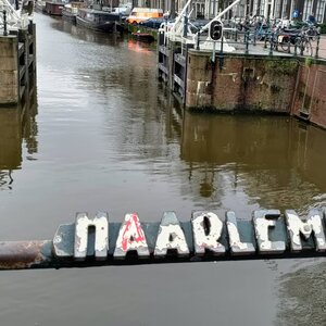
By now you don’t need me to tell you then that this is a lock not a bridge. Sluis vs Brug. The Haarlemmersluis is also called the Nieuwe Haarlemmersluis to distinguish it from the Oude Haarlemmersluis, which was in the Martelaarsgracht before it was filled in in 1882.
The Haarlemmersluis is a 17th-century lock in the centre of Amsterdam. The lock is located at the eastern end of the Brouwersgracht, where the Singel flows into the IJ. The fixed bridge (bridge number 14) at the lock connects the Nieuwendijk and Haarlemmerstraat and is a popular tourist spot and large numbers of tourist canal boats pass through it.
During the refreshment of the canal water at night, the Haarlemmersluis or the Eenhoornsluis are closed; however, they are never closed at the same time, so that night-time water traffic between the IJ and the canal belt remains possible.

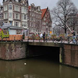


The Haarlemmersluis is located at the eastern end of the Brouwersgracht, where the Singel flows into the IJ. The fixed bridge (bridge number 14) at the lock connects the Nieuwendijk and Haarlemmerstraat.
The Haarlemmersluis Bridge 14 is also known as the Nieuwe Haarlemmersluis, to distinguish it from the Oude Haarlemmersluis, which was located in the Martelaarsgracht before it was removed when that canal was filled in in 1882.
Old Haarlemmersluis
The original (Oude) Haarlemmersluis was built to replace the Spaarndammersluis that was demolished in 1506. That lock was located at the junction of Nieuwendijk and Martelaarsgracht. On the city map of Cornelis Anthonisz. from 1544, the lock is clearly recognisable by its four wheels. The lock disappeared when the Martelaarsgracht was filled in in 1882.
A cartouche dating back to 1596 from the Old Haarlemmersluis is now located in the wall of the former synagogue at 91 Nieuwe Uilenburgerstraat the cartouche was placed in 1957 with the coat of arms of Amsterdam with two lions and the imperial crown.

New Haarlemmersluis
The Nieuwe Haarlemmersluis was completed in 1602 (so not really that new but everything is relative I guess), as a lock in the sea dyke around the city, to prevent the seawater from flowing into the canals at high tide. At the site of the new lock was originally the old city wall which was demolished from 1601 to expand the city westwards and the lock immediately became an important part of the city’s infrastructure because a series of markets were held along the Singel, all of which were served by barges. Barges also went back and forth to the breweries on Brouwersgracht, there were ferry services, milk barges from Waterland and construction traffic to the new canals in the canal belt.
Already by 1617 the lock construction needed to be renewed and to relieve the pressure on the Haarlemmersluis the city decided to build yet another new lock, the Eenhoornsluis, where the Korte Prinsengracht flows into the IJ. The current Haarlemmersluis dates from 1681. The bridge was built in 1809 and widened for the horse tram in 1879.
At the Nieuwe Haarlemmersluis, the ebb and flow height in the IJ River was measured daily. The data showed that between 1683 and 1684, the average nightly flood level of the IJ water was half an inch higher than the city buoy level, later called Amsterdams Peil.
The area around the lock was a fish market for centuries. The Amsterdam herring trade was concentrated along the quay on the IJ, between the Martelaarsgracht and the Haarlemmersluis, the “Haringpakkerij” with the Haringpakkerstoren at its centre. Here, the herring was inspected, rinsed clean, salted again, cured and traded. In 1662 the Kleine Vismarkt (Small Fish Market) was established at the lock, to distinguish it from the Grote Vismarkt on Dam Square. After the Haringpakkerstoren was demolished in 1829 the herring trade disappeared from the area around the lock.


