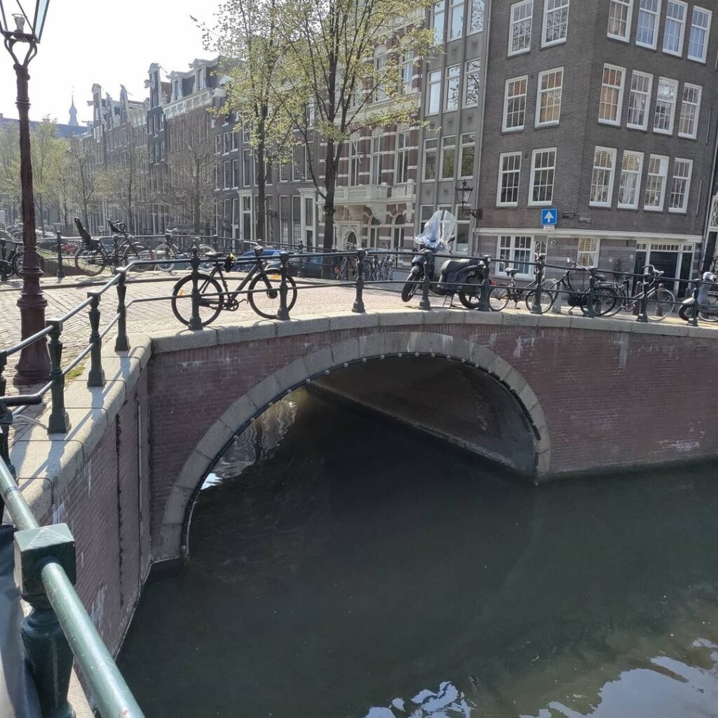
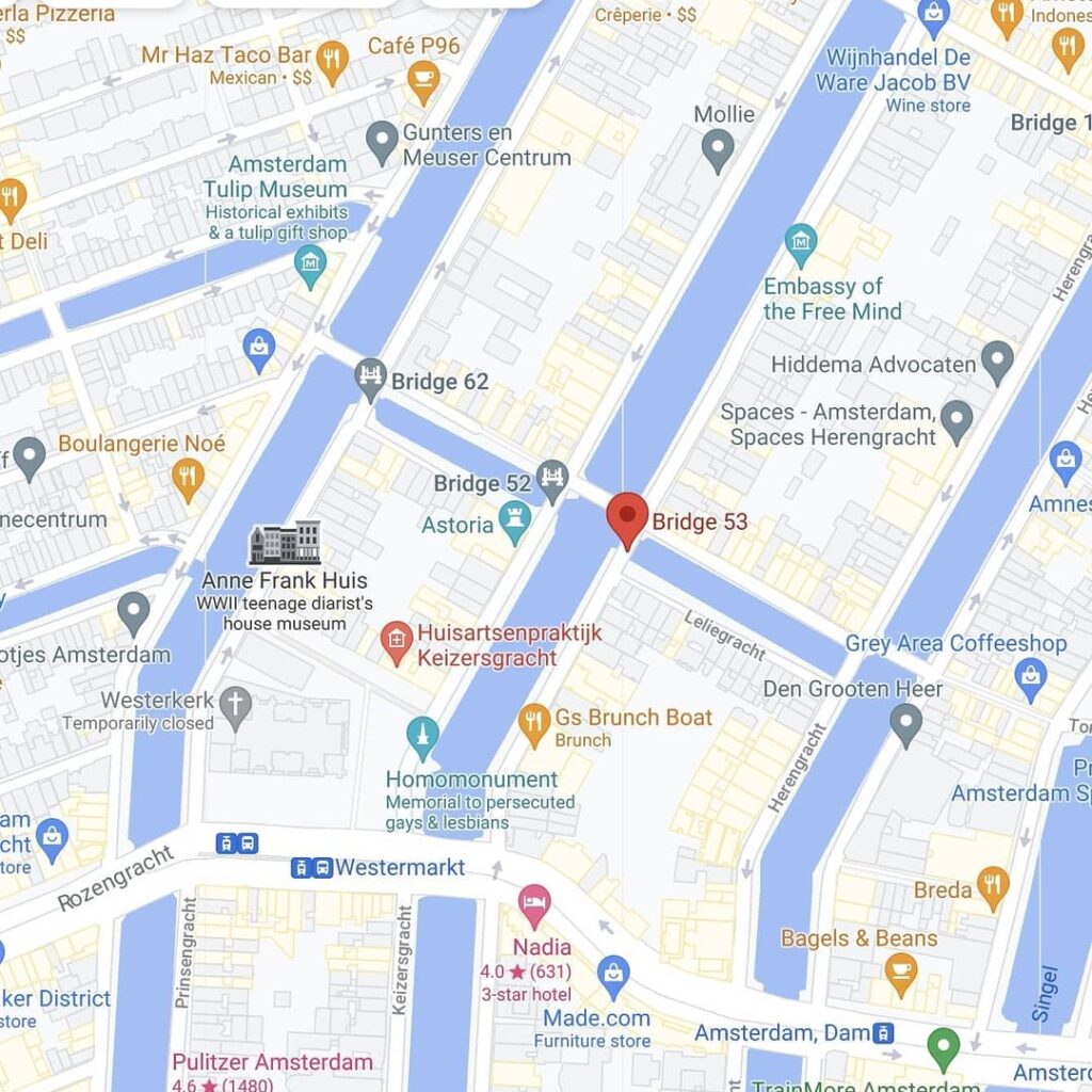
Bridge 53 (Brug drieenvijftig)
Remaining on the Keisersgracht and the junction with Leliegracht to continue our journey. Road bridge 53 is located on the eastern quay of the Keizersgracht spanning the Leliegracht. It is flanked by #bridge51 (adjoining) and #bridge52 (on the opposite side of Keizersgracht), spanning the Keizersgracht and the Leliegracht respectively.
All three bridges are fake antique as they were rebuilt in the early 1980’s along with the previous bridges along the #keisersgracht and whilst you can’t see it from my pictures numbers 53 (west side) and 1979 (east side) can be read on two stones.


The Bridge Facing the Square
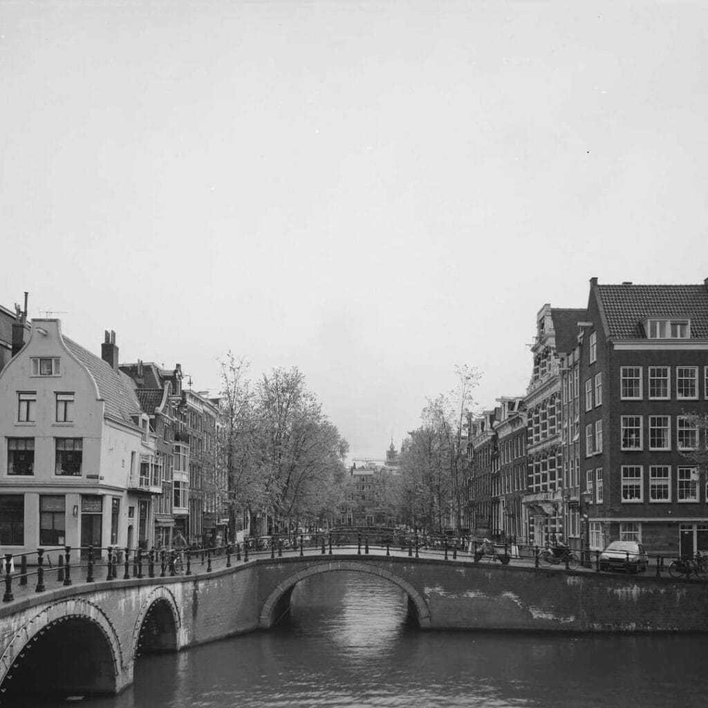
Of the three crossings that together form the Keizersgracht-Leliegracht bridge complex, Bridge 53 occupies the position of greatest civic visibility. It sits on the eastern quay of the Keizersgracht, the Westermarkt side, at the point where the Leliegracht opens toward the city’s most iconic square and church. Where Bridge 52 looks out westward over the Jordaan, Bridge 53 looks directly eastward toward the Westerkerk tower, the Homomonument’s pink granite triangles, and the historic townhouses of the Westermarkt embankment. It is the crossing that faces the city.
And yet Bridge 53, like its siblings, carries no official proper name in the municipal register of the Dienst der Publieke Werken. Its identity is its number, stamped into the stone on the west face of its parapet: 53. On the east face, the companion stone carries the year of its most recent structural birth: 1979. This is the first crucial distinction between Bridge 53 and the other two members of the trinity. Of bridges 51, 52, and 53, Bridge 53 was the first to be completed in the late-20th-century reconstruction campaign. It was finished in 1979, at least two years before Bridge 52 and nearly three years before Bridge 51, which was completed last, in around August 1982. The three bridges share a common history, but they did not share a common moment of rebirth, and Bridge 53 was the one with which the city began.
Geography and Position: The City-Facing Quay
Bridge 53 is located on the eastern quay of the Keizersgracht and spans the Leliegracht. It is flanked by Bridge 51 (adjoining, crossing the Keizersgracht itself) and Bridge 52 (on the opposite, western quay of the Keizersgracht), spanning the Keizersgracht and the Leliegracht respectively.
The eastern quay of the Keizersgracht at this point is the odd-numbered side, the side that faces toward the heart of the city, toward Dam Square and the old town. The Westermarkt square opens onto the Keizersgracht just a few paces north of Bridge 53. The Westerkerk, with its tower of 85 metres, rises almost directly in the bridge’s sightline when viewed from the eastern parapet. The Homomonument, designed by architect and artist Karin Daan and unveiled on 5 September 1987, sits on the bank of the Keizersgracht on the Westermarkt embankment, its first pink granite triangle stepping down to a platform that rests upon the canal water. Bridge 53 is the nearest bridge to that water-level triangle, making it the crossing from which the Homomonument’s most intimate relationship with the Keizersgracht can be observed.
This adjacency is worth pausing over. When the Homomonument Foundation was established in the spring of 1979, the same year that Bridge 53 was being rebuilt as the first of the three Leliegracht crossings to receive its new concrete span, the two projects were proceeding simultaneously in the same stretch of canal. Workers were dismantling and numbering the old stones of Bridge 53 on the eastern quay while, a short walk away, the initial advocacy for a monument to persecuted homosexuals was building momentum. The bridge that emerged in 1979 and the monument unveiled in 1987 now share the same slice of Amsterdam, separated by little more than a canal’s width and a decade of civic history.
The Stereoscope’s Witness: What the 1880s Photographers Saw
Bridge 53 possesses a documentary distinction that sets it apart from its two sibling crossings: it is the only one of the three for which stereoscopic photographic evidence from around 1880 survives in the public archive.
Two stereoscope images of Bridge 53, taken around 1880, are held in the Stadsarchief Amsterdam collection and catalogued in the Wikimedia Commons Brug 53 category. One was made by P.H.J. Reynet de la Rue (1839-1927), a photographer active in the Amsterdam area during the second half of the 19th century. The other was made by Andreas Theodorus Rooswinkel (1838-1909), one of the most prolific commercial photographers of 19th-century Amsterdam, who worked extensively along the Keizersgracht producing stereoscopic cabinet photographs for the publisher Gebroeders Douwes. Both images are viewable via the Wikimedia Commons archive under the Brug 53 and Stadsarchief Amsterdam categories.
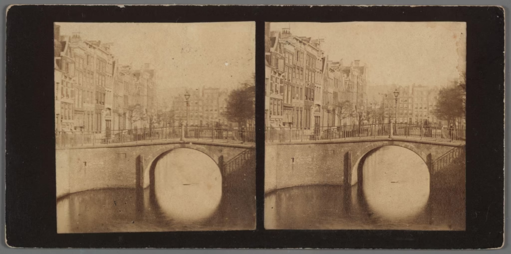
Stereoscopic photography, which produces a three-dimensional illusion when viewed through a stereoscope viewer, was a popular form of middle-class entertainment and documentary record in the 1870s and 1880s. Rooswinkel in particular produced hundreds of stereoscope card pairs of Amsterdam’s canals, capturing the city’s bridges, warehouses, canal houses, and waterways in a format that preserved extraordinary spatial depth. His images of the Keizersgracht routinely show the bridges of the canal in their pre-1892 condition, with their high-arched stone profiles still intact before the great lowering campaigns of the late 19th century.
What these two stereoscope images of Bridge 53 capture, then, is the bridge as it stood sometime in the decade before the 1892 joint lowering of bridges 51, 52, and 53. They show a structure that was already decades old by 1880, one that had been rebuilt or substantially repaired at various points since the 17th century, and which still retained something of the arched masonry character that the canal ring was designed to project. This visual evidence is the earliest photographic record of any of the three Leliegracht crossings, making Bridge 53 the most photographically documented of the trio from the pre-modern era.
A Cartographic Prologue: 1618 to 1649
Like its twin crossings, Bridge 53 can be traced to the earliest years of the Keizersgracht’s existence. On the map of Balthasar Florisz. van Berckenrode from 1625, a bridge with three passages is drawn over the Lely Graft in the Keysers Graft, with the Lely Sluys behind it. The plot division map from around 1618, when the Keizersgracht lots had only just been fully allocated, showed a bridge here with five arches. And Joan Blaeu’s 1649 map depicted a single-passage crossing.
The interpretive challenge for this location is the same as for bridges 51 and 52: the cartographic record reflects a single bridge complex spanning the full width of the Leliegracht junction across both quays, not three separate bridges. The van Berckenrode map’s three-passage bridge, the 1618 five-arch structure, and the Blaeu single span all refer to the same junction, which was later divided into three discrete crossings as the city’s municipal numbering system matured. Bridge 53, in this reading, is the eastern portion of a crossing that has existed in some form at this point since the earliest years of the Canal District’s construction.
The Leliegracht itself, as established in the two previous posts in this series, was dug after 1612 as a hydraulic connector between the higher-level water of the main canal ring and the lower-level water of the Jordaan polder canals. The Leliesluis at the Prinsengracht end of the canal managed this water-level gradient. Bridge 53 stands at the Keizersgracht end of this same hydraulic corridor, marking the point where the canal opens into the great breadth of the Emperor’s waterway. It is a threshold bridge in the fullest sense: the crossing that separates the intimate scale of the Leliegracht from the monumental scale of the Keizersgracht.
The 1892 Lowering and the Shape of a Century
In 1892, a new tender took place and the three bridges (51, 52, and 53) had to be lowered. This was the same campaign of modernisation, driven by the demands of horse-drawn trams and heavy goods transport, that transformed the bridge profiles across the entire northern canal belt in the late 19th century. The high, humpbacked masonry vault was incompatible with the flat, level decks required by iron-wheeled vehicles and, increasingly, electric tram rails.
For Bridge 53, the 1892 lowering meant the end of the arched form captured by Rooswinkel and Reynet de la Rue in their stereoscope images of around 1880. The bridge that replaced it, like Bridge 52, would have been a flat or very low-profile crossing, probably with an iron girder deck. This is the form that stood for nearly a century, carrying the traffic of the Westermarkt neighbourhood across the mouth of the Leliegracht, until the restoration campaign of 1979 to 1982 intervened.
1979: Where the Restoration Began
The date stone embedded in the eastern face of Bridge 53’s parapet reads “1979,” and this is the most significant single fact about the bridge in its modern form. It identifies Bridge 53 as the starting point of the entire Keizersgracht-Leliegracht bridge complex reconstruction. The campaign that would eventually restore all three crossings to their current stone-clad arch appearance began here, on the eastern quay, facing the Westermarkt.
The reconstruction method was the same for all three bridges: the pre-numbered stones were removed from the existing structure, the old deck was demolished, a new reinforced concrete structural span was poured, and the original stones were then reset in their numbered positions around the new core, to give the bridge an “antique” appearance, while the bridge was given a concrete span, an architectural lie. For Bridge 53, this process was completed in 1979. Bridge 52 followed, with its date stone reading “1982” on the west face. Bridge 51, the last to be finished, was completed around August 1982.
The staggered completion sequence, Bridge 53 first, then 52, then 51, is consistent with the logistical demands of a multi-bridge restoration on a busy urban waterway. Working from the eastern quay inward, the team would have been able to maintain access via the adjacent crossings while each bridge was under reconstruction. The decision to begin with Bridge 53, the city-facing one, may also reflect a prioritisation of the most publicly visible and symbolically prominent crossing in the complex.
The pre-numbering of stones is worth underlining as a technical achievement. Each stone in the existing bridge’s facing was marked before removal, its position in the overall structure recorded, and the entire facing dismantled in an organised sequence. The stones were then stored, the concrete span poured and cured, and the stones reset in their original order. Bridge numbers 52 (east side) in 1982 (west side) and 53 (west side) and 1979 (east side) can be read on two bridges. This double-sided testimony, the catalogue number on one face and the construction year on the other, is the most transparent possible declaration of what has been done. The stones that look old are old. The structure that holds them up is new.
The Homomonument: A Monument Born the Same Year as the Bridge
The Homomonument, which stands on the bank of the Keizersgracht within sight of Bridge 53, was designed by Amsterdam-born artist Karin Daan in 1979, and officially unveiled in September 1987. Its commission emerged from a movement that had been building since at least 1961, when poet and activist Jef Last dreamed of a “monument to the unknown gay,” and gained formal institutional momentum in 1979 with the founding of the Homomonument Foundation. In 1980, artists were invited to submit designs, and a jury selected Daan’s composition of three equilateral pink granite triangles.
The monument takes the form of three large pink triangles made of granite, set into the ground so as to form a larger triangle, on the bank of the Keizersgracht canal, near the historic Westerkerk church. It was the first monument in the world to commemorate gays and lesbians who were killed by the German Nazi regime. The reclaimed pink triangle, which the Nazi regime had used to identify gay men in concentration camps, was transformed by the Homomonument into a symbol of remembrance and future hope. The first triangle steps down to a platform resting on the Keizersgracht water: this is the triangle closest to Bridge 53’s eastern abutment.
The coincidence of dates, 1979 for both the bridge reconstruction’s commencement and the founding of the Homomonument Foundation, creates an unexpected historical rhyme at this corner of the city. Two acts of civic repair and civic declaration, one material and one memorial, began in the same year at the same stretch of canal. The bridge was given new bones while the square was being prepared for a new kind of monument. They are not related. But they share a moment, and they share a place, and together they make the eastern Keizersgracht corner at the Leliegracht one of the most historically textured intersections in Amsterdam.
Every year, on the National Day of Remembrance on 4 May, the Homomonument hosts an official ceremony. Bridge 53 is the crossing nearest to this gathering, the bridge over which flowers and participants pass from the Jordaan side to the Westermarkt embankment. On King’s Day and Liberation Day, the Westermarkt hosts its festivals, and Bridge 53 carries the crowds moving between the canal’s two banks.
Architectural Character and the Eastern Sightline
Bridge 53 is a fixed vault bridge (vaste wulfbrug) in its outward form, presenting as a single-arch masonry crossing over the Leliegracht mouth at the eastern Keizersgracht quay. Its structural span is reinforced concrete from the 1979 reconstruction, clad in the pre-numbered original stones. The bridge carries wrought iron railings in the standard municipal pattern used for the 1980s canal ring restorations, granite nose-protection stones at the canal-facing abutment corners, and the two embedded date stones: “53” west face, “1979” east face.
In a detail noted in the archive photograph collection from the Collectie Het Grachtenboek (around 1990, photographer Annemieke van Oord-de Pee), Bridge 53 appears in the same frame as Bridge 51, demonstrating how closely the two crossings flank the Keizersgracht crossing of Bridge 51. The caption for this image reads: “Op de voorgrond links brug 51 en rechts de aanzet van brug 53,” meaning “In the foreground on the left Bridge 51 and on the right the start of Bridge 53.” This image captures the ensemble of the entire Keizersgracht-Leliegracht junction in its post-1982 restored form.
The sightline from Bridge 53’s eastern parapet is among the most celebrated in the canal ring. Looking northeast along the Keizersgracht from this point, with the Westertoren rising above the Westermarkt roofline and the Homomonument’s water triangle visible in the foreground at canal level, the view synthesises five centuries of Amsterdam urban history into a single frame: the 17th-century canal engineering, the 17th-century church, the 20th-century memorial, and the late-20th-century restored bridge deck underfoot. At dusk, when the bridge lanterns are lit and the Westertoren’s crown catches the fading western sky, the view is one of the most reliably photographed in the city.
There is no bridge-keeper’s house at Bridge 53. As a fixed bridge, it required no operational staff, and since 2012 all remaining movable bridges in Amsterdam’s centre are managed remotely from a central control room.
Urban Context: The Most Monument-Dense Crossing
Bridge 53 sits at an intersection of civic memorials unmatched by either of its sibling crossings. Within a radius of 200 metres of the bridge:
The Westerkerk, the Reformed Protestant church completed in 1631 to designs by Hendrick de Keyser and his son Pieter, with its 85-metre Westertoren topped by the blue Imperial crown of Maximilian I. The carillon of the Westertoren plays regularly throughout the day, and the church’s bells are the same ones Anne Frank described hearing during her years in hiding, documented in her diary. The Homomonument (1987), the world’s first public monument dedicated to persecuted LGBTQ+ people, designed by Karin Daan, with its pink granite triangles set into the Westermarkt embankment beside the Keizersgracht. The Anne Frank House on the Prinsengracht, a short walk southwest, where Anne Frank, her family, and four others hid from 1942 to 1944. The Westermarkt square itself, one of Amsterdam’s historic market squares, which hosts regular commemorative gatherings, King’s Day festivities, and seasonal markets. The Astoria building (Keizersgracht 174-176), the 1904-1905 Jugendstil rijksmonument visible across the canal, whose Greenpeace legacy and Art Nouveau copper crown create a striking counterpoint to the surrounding Golden Age architecture.
No other bridge in the 51-52-53 trinity commands this concentration of historically significant neighbours. Bridge 53 is, in this sense, not merely a canal crossing but a civic threshold, the bridge at the foot of Amsterdam’s most publicly witnessed square.
Technical Specifications Summary
Bridge type: Fixed vault bridge (vaste wulfbrug). The exterior presents as a single-arch masonry crossing. The structural span is reinforced concrete, installed during the 1979 reconstruction, the first of the three Leliegracht bridges to be completed.
Materials: Natural stone cladding (pre-numbered original stones, reset in 1979) over a reinforced concrete structural core. Wrought iron railings in municipal standard pattern. Granite nose-protection stones at the canal-facing abutment corners.
Location: Keizersgracht, eastern quay, at the mouth of the Leliegracht. Adjacent to the Westermarkt. Flanked by Bridge 51 (spanning the Keizersgracht) and Bridge 52 (western quay, spanning the Leliegracht).
Catalogue number: 53, per the Index of Bridges in Amsterdam maintained by the Dienst der Publieke Werken.
Key dates: Earliest cartographic evidence of a bridge at this location, circa 1618 (five arches). Balthasar Florisz. van Berckenrode map, 1625 (three passages). Joan Blaeu map, 1649 (single passage). Stereoscope photographs by Rooswinkel and Reynet de la Rue, circa 1880, showing pre-1892 form. Joint lowering and widening with bridges 51 and 52, 1892. Reconstruction begins, 1979. Bridge 53 completed, 1979, the first of the three to be finished.
Date stones: “53” on the west face parapet; “1979” on the east face parapet.
Earliest photographic record: Stereoscope images by P.H.J. Reynet de la Rue and A.T. Rooswinkel, circa 1880. Held in the Stadsarchief Amsterdam; catalogued in Wikimedia Commons under Category: Brug 53 (in Amsterdam).
Designers: The 1892 lowering and the 1979 reconstruction were both products of the Dienst der Publieke Werken’s engineering and architectural departments, without confirmed individual architect attribution.
No bridge-keeper’s house. Fixed bridge, remote operation from central control room since 2012.
Nearest monument: The Homomonument (unveiled 1987, designed by Karin Daan) is on the Keizersgracht bank within direct sight of Bridge 53’s eastern abutment.
Closing Thought: The First of Three
There is something fitting about the order in which the three bridges were rebuilt. Bridge 53, the most publicly exposed, the one facing the Westermarkt, was the one with which the city began in 1979. It was the test case, the first act of what would become a three-bridge, three-year programme of civic re-historicisation. The pre-numbered stones were removed, the concrete poured, the stones reset. The city watched to see if it worked. It did. Bridge 52 followed, then Bridge 51, last of all, in August 1982.
The Homomonument Foundation was formally established in that same year, 1979, at the other end of the same stretch of canal. Its monument would take eight more years to be unveiled. The bridge took three. But they were conceived in the same civic moment: an Amsterdam that was beginning, carefully and thoughtfully, to decide which parts of itself it wanted to remember and which truths it was prepared to inscribe in stone.
Bridge 53 carries two of those truths in its own parapet: the catalogue number that gives it its identity within the city’s infrastructure, and the year that tells you when its current form was actually made. Everything else about it, the arching masonry, the granite nose stones, the wrought iron railings, is a considered, well-intentioned, and entirely transparent performance of historical continuity. It is the first stone of the beautiful lie. And it faces the square.
Brug 53 map and location
Bridge 53 is located in the eastern quay of the Keizersgracht and spans the Leliegracht. It is flanked by #bridge51 (adjoining) and #bridge53 (on the opposite side of Keizersgracht), spanning the Keizersgracht and the Leliegracht.
There has been a bridge here for centuries. On the map of Balthasar Florisz. van Berckenrode from 1625 is a bridge with three passages drawn over the Lely Graft in the Keysers Graft with the Lely Sluys behind it. However, the map with the plot division south of the Leliegracht between Keizersgracht and Prinsengracht from around 1618 also showed a bridge (five arches). Joan Blaeu , however, drew a bridge with a passage on his map from 1649.

Bridge 53 information and history
The modern history of #bridge53 is obviously very similar to #bridge52 and #bridge 51.
In 1892 a new tender took place and the three bridges (51, 52 and 53) had to be lowered. It was not until almost a century later that there was work to be done again from 1979 to mid-1982 the bridge complex was under construction, with bridge 51 being completed last (around August 1982). The stones were pre-numbered to make the work go smoothly. Bridge numbers 52 (east side) in 1982 (west side) and 53 (west side) and 1979 (east side) can be read on two bridges. All this is to give the bridges an “antique” appearance, while the bridges are given a concrete span although an architectural lie.


Bridge 53
Photos from the archive
1 bridge 53 stereoscope image around 1880 Reynet de la Rue, P.H.J. (1839-1927)
2 bridge 53 stereoscope image around 1880 Rooswinkel, Andreas Theodorus (1838-1909)
3 Bridge 51 and 53 Annemieke van Oord-de Pee, Collectie Het Grachtenboek 1990 ca.
Sources and Archival References
- Cramberts / Bridges of Amsterdam (bridges.cramberts.com): “Brug drieenvijftig, Bridge 53: History and Information,” April 2022 (updated October 2023). Primary source for the 1892 joint lowering, the 1979 to 1982 reconstruction sequence, the pre-numbered stone account, the date stamps, the stereoscope image credits, and the Annemieke van Oord-de Pee photograph caption. https://bridges.cramberts.com/amsterdam/history/brug-drieenvijftig-bridge-53-history-and-information/
- Cramberts / Bridges of Amsterdam (bridges.cramberts.com): “Brug drieenvijftig, Bridge 53: Amsterdam,” April 2022. Confirms position on the eastern quay, flanking relationship with bridges 51 and 52, and date stones (west side “53,” east side “1979”). https://bridges.cramberts.com/amsterdam/bridges/brug-drieenvijftig-bridge-53-amsterdam/
- Cramberts / Bridges of Amsterdam (bridges.cramberts.com): “Brug drieenvijftig, Bridge 53: Map and Location,” April 2022. Confirms eastern quay position, van Berckenrode 1625 cartographic evidence, 1618 plot map evidence, and Blaeu 1649 evidence. https://bridges.cramberts.com/amsterdam/map/brug-drieenvijftig-bridge-53-map-and-location/
- Wikipedia, “Homomonument”: Full history, design, unveiling (5 September 1987), architect Karin Daan, and the 1979 founding of the Homomonument Foundation. Confirms position on the Keizersgracht bank beside the Westerkerk. https://en.wikipedia.org/wiki/Homomonument
- I Amsterdam official guide (iamsterdam.com): “Homomonument.” Confirms design year (1979), official unveiling (September 1987), and location at Westermarkt. https://www.iamsterdam.com/en/whats-on/calendar/attractions-and-sights/sights/homomonument
- Wikimedia Commons, Category: Brug 53 (in Amsterdam): Photographic archive including the two Rooswinkel and Reynet de la Rue stereoscope images (circa 1880), the modern bridge photograph (“Brug 53 in de Keizersgracht over de Leliegracht foto 3.jpg”), the aerial RCE overview (“Overzicht van af Westertoren naar het oost noord-oosten, Amsterdam, 20010818, RCE.jpg”), and the Annemieke van Oord-de Pee “Collectie Het Grachtenboek” image (circa 1990). https://commons.wikimedia.org/wiki/Category:Brug_53_(in_Amsterdam)
- Wikipedia, “Keizersgracht”: Canal history, excavation date (1615), naming (Maximilian I), bridge inventory, and the Homomonument’s relationship to the canal (the water-level triangle). https://en.wikipedia.org/wiki/Keizersgracht
- Wikipedia, “Leliegracht”: Canal etymology, post-1612 construction, Leliesluis lock history, and survival through the 19th-century infilling campaigns. https://en.wikipedia.org/wiki/Leliegracht
- Stadsarchief Amsterdam Beeldbank: Primary archive for the Rooswinkel and Reynet de la Rue stereoscope images, the Collectie Het Grachtenboek photographs, and other historical images of the bridge and its context. https://archief.amsterdam/beeldbank/
- Balthasar Florisz. van Berckenrode, Map of Amsterdam, 1625: Earliest confirmed cartographic reference to a bridge with three passages at the Lely Graft-Keysers Graft junction. Held in multiple Dutch public collections including the Stadsarchief Amsterdam.
- Cramberts / Bridges of Amsterdam (bridges.cramberts.com): “Brug Eenenvijftig, Bridge 51: History and Information.” Corroborating source for the sequence of bridge completions: Bridge 51 last, August 1982. Also source for the archive caption “Op de voorgrond links brug 51 en rechts de aanzet van brug 53.” https://bridges.cramberts.com/2022/04/05/brug-eenenvijftig-bridge-51-history-and-information/
- Wikipedia, “Westerkerk”: Height (85 metres), architects (Hendrick de Keyser and Pieter de Keyser), completion date (1631), and bell carillon documented by Anne Frank. https://en.wikipedia.org/wiki/Westerkerk
- Grokipedia, “Leliegracht”: Detailed account of the Leliesluis hydraulic corridor, the canal’s role in managing water level differentials, and the 1612-era construction context. https://grokipedia.com/page/leliegracht