
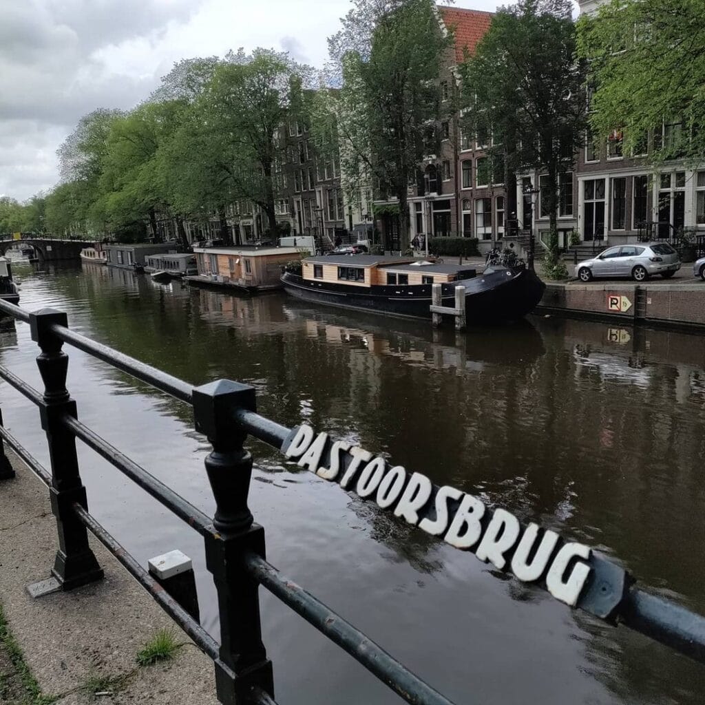
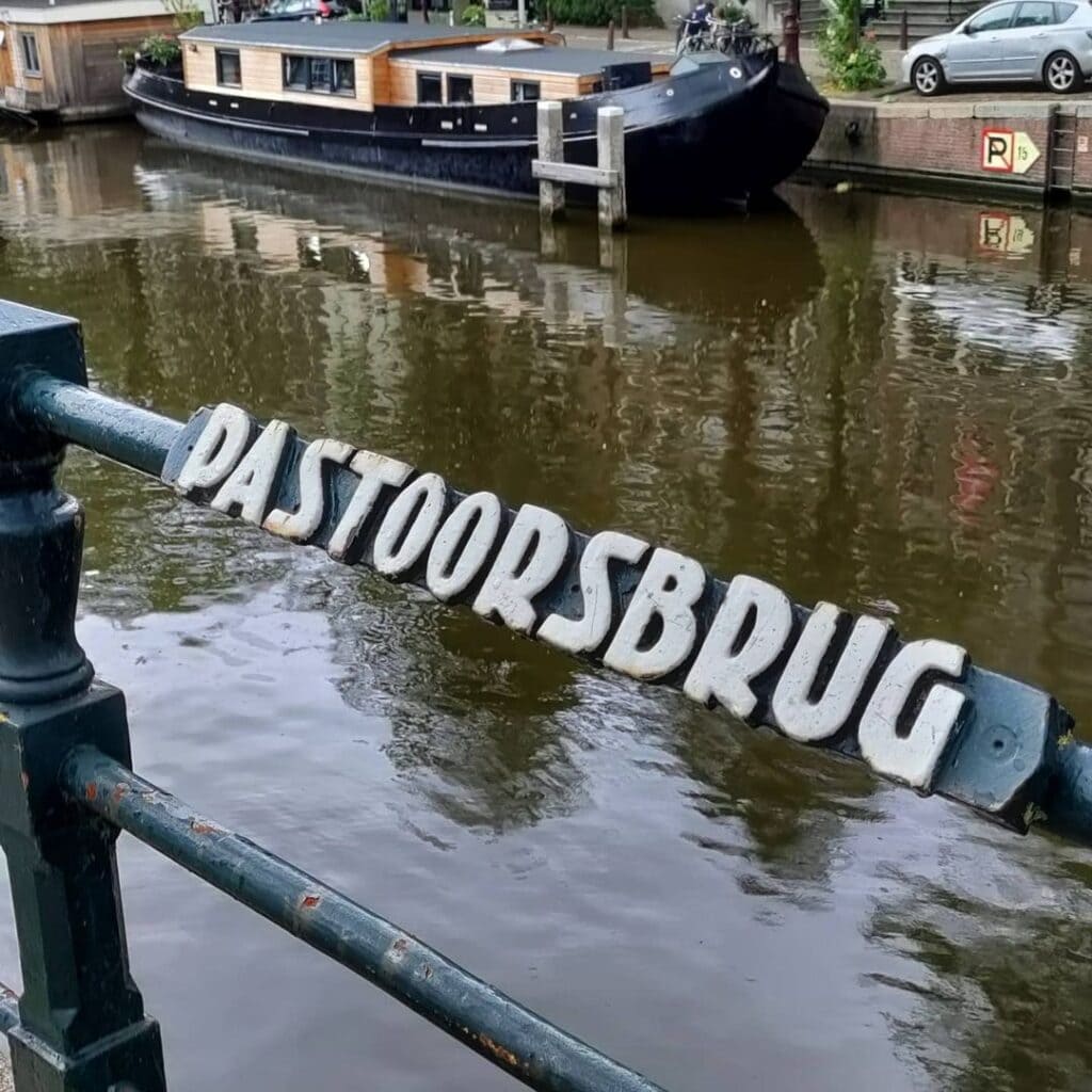
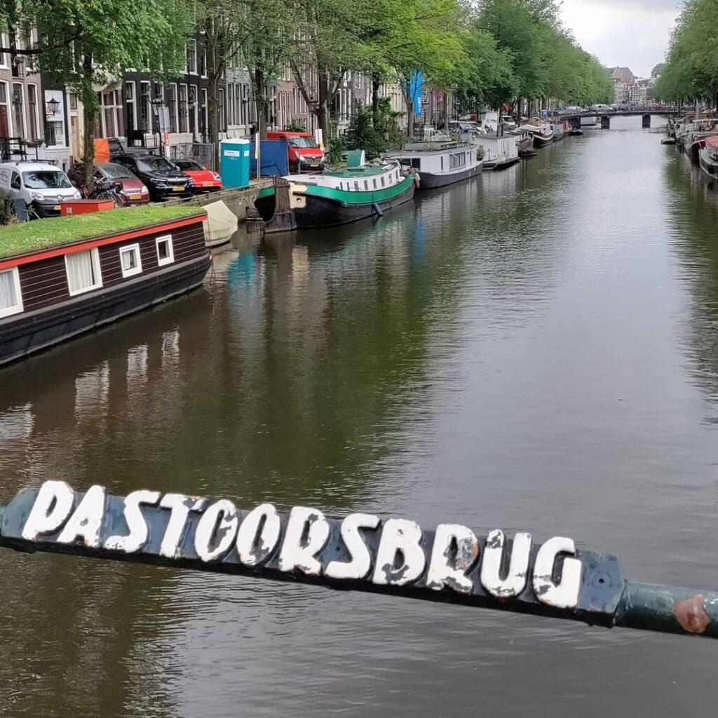
Pastoorsbrug (The Pastor’s Bridge number 55)
Located in the southern quay of the Brouwersgracht spanning the Keizersgracht. It is therefore the northernmost bridge over Keizersgracht since it does not continue on the other side of the Brouwersgracht. The bridge is relatively young and is not a monument itself but it shares the quay wall with #bridge56 which is a municipal monument.
Another nickname for the bridge is Kippenbrug, which goes back to the general term for pedestrian bridges in Amsterdam.
It is not clear where the name Pastoorsbrug comes from although it is suspected that it may have to do with a nearby hidden church at number 22 from around 1663 and its replacement the Sint Ignatiuskerk (also called De Zaaier) from around 1837.


The Mystery of the Name: A Pastor, a Warehouse, and a Hidden Church
Of all the questions that cluster around Brug 55, the most persistently fascinating concerns its name. The Pastoorsbrug, literally the “Pastor’s Bridge,” carries a title that is simultaneously evocative and elusive. No entry in the municipal bridge registers offers a definitive origin, and the city’s archivists themselves acknowledge that the precise provenance of the name is no longer traceable with certainty. What survives is a compelling and well-supported hypothesis: that the bridge was named for the Roman Catholic priestly community that operated, for more than two and a half centuries, from the very canal house it overlooks.
The story begins in 1663. Under the Dutch Reformed-dominated Republic, Roman Catholics were forbidden from constructing visible churches with towers, bells, or street-facing facades identifiable as places of worship. Instead, they organised worship in schuilkerken, hidden churches concealed within the upper floors and back rooms of domestic buildings. In that year, the Jesuit father Henricus van Alckemade established a statie (a Jesuit mission post) in the warehouse at what is now Keizersgracht 22, a building whose name, “De Sayer” (the Sower), was inscribed on its facade. The name was itself a quietly coded reference: Jesuit missionaries liked to think of themselves as sowers of the Gospel, and the building’s existing name aligned neatly with the biblical image of the sower going out to sow, “Exiit seminans ad seminandum,” as the Latin inscription would later read on the church that replaced it.
For over 170 years, the Jesuit fathers ministered from this address to the Catholic population of the Jordaan and surrounding neighbourhood, operating in a city where their faith was technically tolerated but architecturally suppressed. As the 19th century brought the formal restoration of Catholic rights in the Netherlands, the cramped hidden church was no longer adequate. In 1833-1837, the old schuilkerk was demolished and replaced with an entirely new building designed by architects Johannes van Straaten and W.J.J. Offenberg: a proper three-aisled hallenkerk (hall church) in a sober neoclassical style, with a classical pediment, decorative statuary, a balustrade, and a small bell tower on the roofline. This was the Sint Ignatiuskerk, universally known by the name of its predecessor warehouse: “De Zaaier.” It was a waterstaatskerk, meaning it was built under the supervision of engineers from the national Rijkswaterstaat and partly financed by the central government, a category of church architecture peculiar to early 19th-century Dutch Catholicism.
The church served the Jordaan’s Catholic community until 1928-1929, when a new and larger Sint Ignatiuskerk, also nicknamed De Zaaier, was erected on the Rozengracht (specifically so that the Jesuits could be at the heart of the Jordaan, which they regarded as their mission territory). The building at Keizersgracht 22 fell out of religious use after 1929, and the original pediment, statuary, and bell tower were removed at some point in the decades that followed. The building subsequently served as offices, and in 1981 it was converted into a mosque. Today the facade still stands at Keizersgracht 22, its Jesuit history readable mainly to those who know where to look.
It is this entire history, the centuries-long presence of Jesuit pastoors (priests) directly at the canal’s edge, that is believed to have given the adjacent bridge its name. There was even an older, now-vanished structure in Amsterdam once recorded as the “Pastoorsburggetje,” suggesting that the association between a canal crossing and a nearby Catholic priestly presence was not unique to this location. Whether the name for Brug 55 was formalised in the 17th century, the 18th, or the early 19th remains unclear, but the connection to Keizersgracht 22 and its succession of Jesuit fathers is the most plausible and most historically grounded explanation that survives.
A Crossing as Old as the Canal Itself
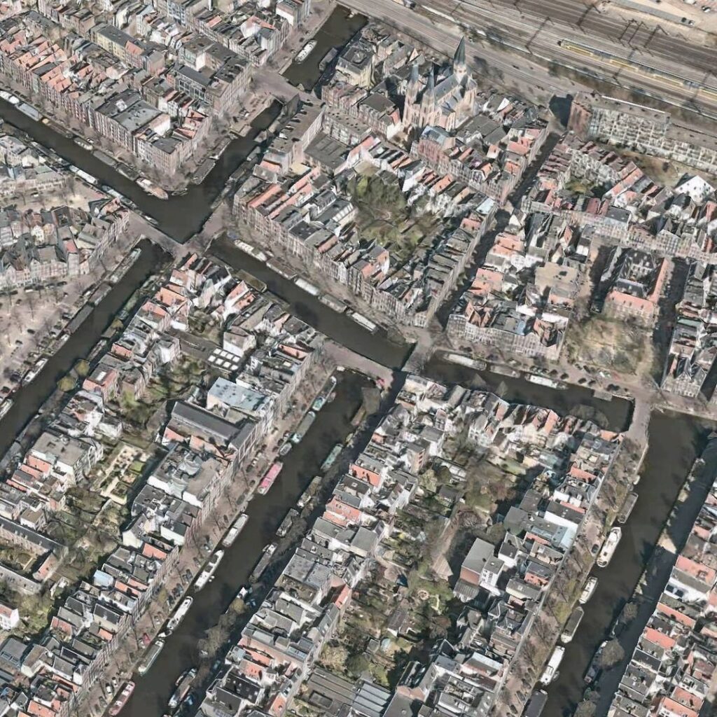
The Keizersgracht, the “Emperor’s Canal,” was dug beginning in the summer of 1615 at the initiative of mayor Frans Hendricksz Oetgens and city carpenter Hendrick Jacobsz Staets, as part of Amsterdam’s great 17th-century canal ring expansion. Named in honour of Holy Roman Emperor Maximilian I, it is the widest of the three principal canals at precisely one hundred Amsterdam feet (approximately 28.31 metres) across. The Brouwersgracht, the Brewers’ Canal, had already been in existence since 1594, serving as the northern backbone of what would become the Jordaan neighbourhood and the northern terminus from which the canal ring’s house numbers begin their count.
A bridge at the junction of these two waterways appears on the earliest detailed maps of the new canal ring. A plot map from 1616 or 1617, drawn at the very moment the northern section of the ring was being laid out, already marks a crossing at this location. The most celebrated early cartographic evidence is the famous isometric city map by Balthasar Florisz. van Berckenrode from 1625, one of the great documents of Amsterdam’s Golden Age urban planning, printed on nine copper-plate sheets and showing every house, warehouse, canal, and bridge in extraordinary three-dimensional detail. The Van Berckenrode map records a bridge crossing the Keizersgracht at the Brouwersgracht, confirming that a structure has served this precise junction for at least four centuries.
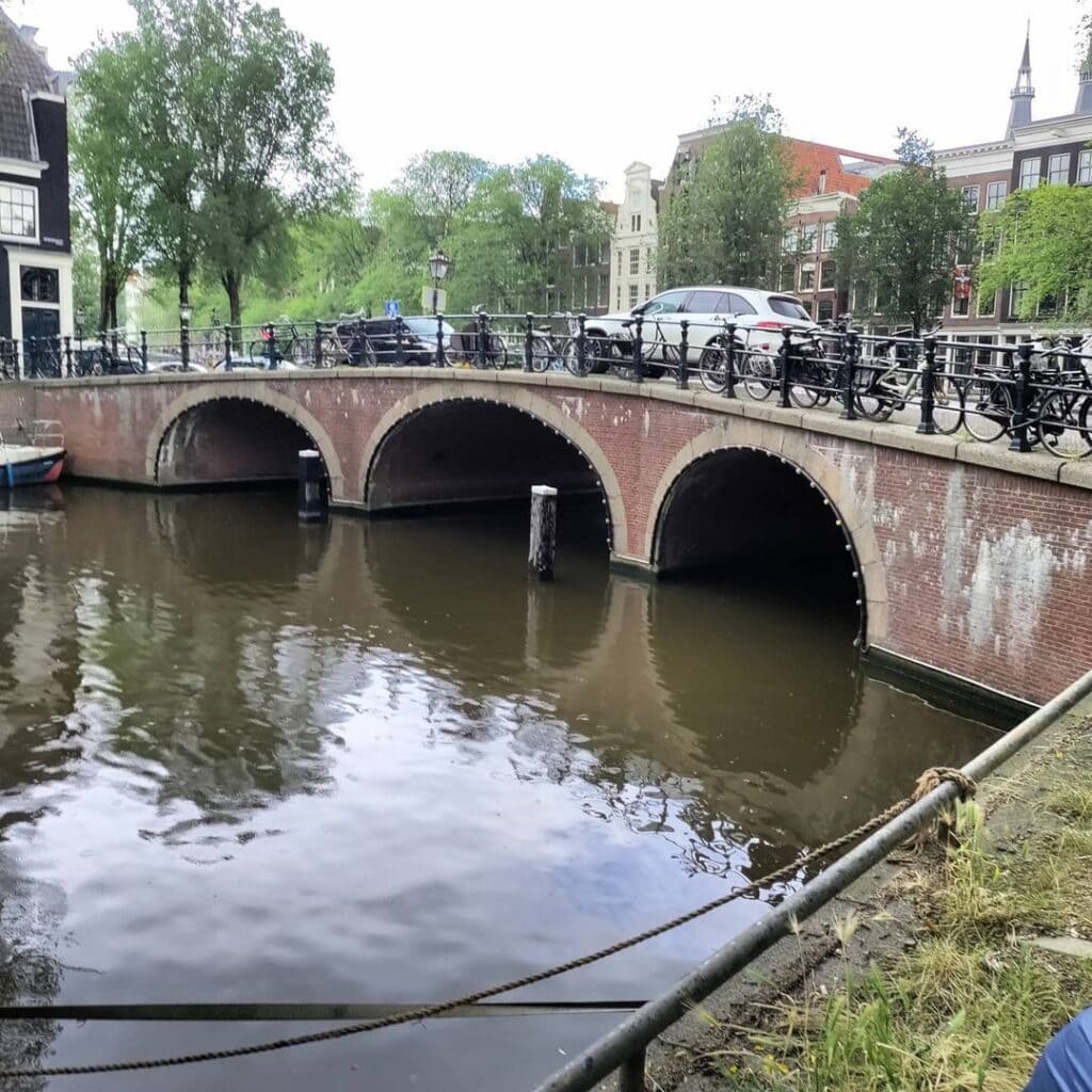
The Pastoorsbrug occupies a particular position in Amsterdam’s canal geography that makes it one of the more distinctive crossings in the ring. It is the northernmost bridge over the Keizersgracht: the canal terminates to the north at the Brouwersgracht, and Bridge 55, sitting in the southern quay wall of that junction, marks the beginning of the entire Keizersgracht bridge sequence. The canal has no continuation to the north of the Brouwersgracht on the far side of this crossing, which gives the bridge an emphatic, boundary-marking character. It is both the first and the last bridge of the Keizersgracht, depending on which direction you are travelling.
Structural Evolution: From Wood to Iron to Brick Arch
The modern structural history of the Pastoorsbrug is one of successive reinventions, each driven by the shifting priorities of Amsterdam’s urban managers, and the final chapter represents one of the more deliberate acts of historical reconstruction undertaken anywhere in the canal ring.
By June 1884, the bridge at this location was a wooden structure. The municipality opened a public tender for the “renewal in iron of the footbridge” and the supply of “over five tonnes of beam iron.” This wooden-to-iron transition was characteristic of the period: across the canal ring, the Dienst Publieke Werken (Public Works Department) was systematically replacing ageing timber structures with modest iron girder footbridges that were durable and inexpensive, if not especially elegant. The resulting iron bridge served the crossing as a voetgangers- en fietsersbrug (a pedestrian and cyclist bridge only), not a vehicle road.
For decades, this situation persisted, though the bridge’s inadequacy for through traffic on the Brouwersgracht became increasingly apparent. By the mid-20th century, the iron footbridge was creating a bottleneck in the movement of vehicles along this important east-west route. The case for a proper traffic bridge had been building for years, but the municipality moved slowly. It was not until June 1963 that Amsterdam finally intervened, releasing a budget of 360,000 guilders for the construction of a full verkeersbrug (traffic bridge).
The decision made at that moment is architecturally significant and worth pausing over. The city had a choice. It could build a modern bridge, flat and functional, of steel and reinforced concrete, consistent with the engineering preferences of the early 1960s. Instead, the municipality decided to build a welfbrug met drie doorvaarten, a masonry arch bridge with three navigable passages, specifically because, in the judgement of those making the decision, such a form would better suit the historic cityscape. The new bridge was completed in 1966.
This was, as the architectural critic and historian Frank V. Smit later acknowledged, a sound decision. He described the approach as “terugrestaureren,” a term meaning something like “restoration towards the original,” and noted that the surrounding buildings were simultaneously renovated with an eye to preserving their old character. The new arch bridge was not a reconstruction of any previous structure at this site: no earlier masonry arch bridge had ever existed here. It was, rather, a historically-inspired new-build, an act of civic design that chose aesthetic continuity with the canal ring’s dominant bridge vocabulary over technological modernity.
This episode placed Brug 55 in an interesting relationship with the broader “verwelving” movement that swept Amsterdam’s inner-city bridges from the late 1960s onwards. Smit’s account establishes the Pastoorsbrug’s 1966 rebuild as one of the early demonstration projects that helped prove the technical and financial feasibility of replacing iron girder bridges with masonry arches on a large scale. The success of Bridge 55, completed just before the larger wave began, helped encourage what became a city-wide programme of arch reconstruction across the canal ring, sometimes praised as sensitive historic restoration, sometimes criticised as that “architectonische leugen,” the architectural lie that sacrificed engineering honesty for aesthetic nostalgia.
Architecture and Detail: A 1960s Bridge That Looks Four Centuries Older
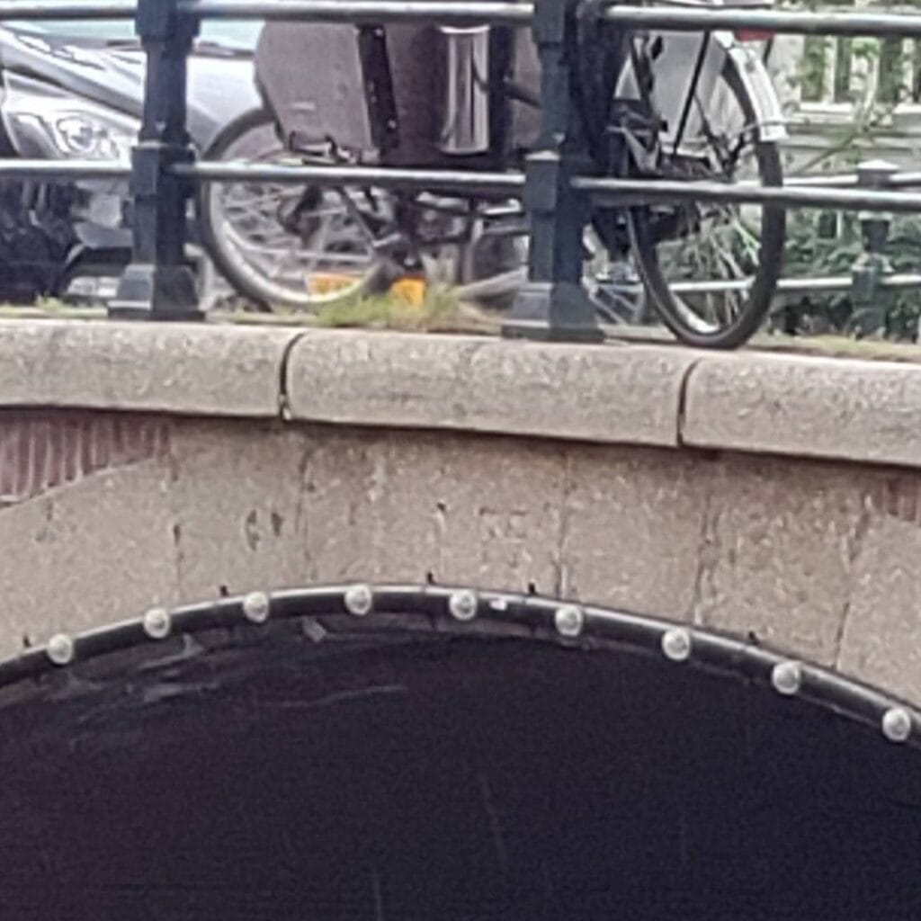
The current Pastoorsbrug is a fixed masonry arch bridge (vaste welfbrug) with three navigable openings (doorvaarten). Its primary material is brick, with stone detailing at the arch faces and parapets, consistent with the vocabulary of the traditional canal ring bridge as established in the 17th and 18th centuries. The three-arch form distributes the load across the width of the Keizersgracht, and the central arch is slightly wider than the two flanking ones, in keeping with classical compositional practice.
The bridge is not, itself, a heritage monument. Its relatively recent construction date of 1966 has excluded it from the designation enjoyed by many of its neighbours. It does, however, share its quay wall with Bridge 56 (Brug 56), a fixed bridge immediately to the east connecting the Binnen Brouwersstraat to the Keizersgracht, which has held the status of gemeentelijk monument (municipal heritage monument) since 1995. The distinction is instructive: Bridge 56 is a genuine 19th-century iron structure of authentic period character, while Bridge 55, despite looking older, is a product of the mid-20th century’s engagement with historic urban design. Both are surrounded by rijksmonumenten (national heritage monuments), the canal houses and warehouses whose protections frame the entire scene.
The bridge carries no integrated bridge-keeper’s house, no Piet Kramer-style sculptural ironwork, and no commemorative plaques. Its design is civic and restrained, aspiring to invisibility within the historic fabric rather than to architectural statement. By any measure it succeeds: to the average visitor pausing on the bridge or photographing the canal, Brug 55 reads as a natural, long-established part of the scene.
At the Intersection of Amsterdam’s Most Beautiful Canal
To understand the Pastoorsbrug fully, one must understand the exceptional character of the junction it inhabits. The Brouwersgracht took its name in 1594 from the brewing industry that clustered at the northern end of what would become the Jordaan. While only a minority of Amsterdam’s breweries were actually located on the canal itself (in 1664, just three of the city’s twenty-two breweries stood directly on the Brouwersgracht), the waterway served as a vital artery for transporting grain, hops, and finished beer barrels between the IJ harbour and the urban market. The warehouses that lined it stored not only brewing materials but also leather, fish, whale oil, coffee, and spices. Many of these warehouses, with their distinctive spout gables, loading hooks, and painted shutters, survive today as residential conversions, their original names still painted on the facades: De Appel, Groene Valk, Spitsbergen, Groot Hert.
In 2007, readers of the Amsterdam newspaper Het Parool voted the Brouwersgracht the most beautiful street in Amsterdam, from a list of 150 nominations. The judgment was hardly surprising to anyone who knows the city well. The canal’s combination of 17th-century warehouses, moored houseboats, ancient bridges, and the long views it offers down the intersecting grand canals makes it one of the most photographed and painted waterscapes in Europe. From the Pastoorsbrug, a visitor can look west along the Brouwersgracht towards the Jordaan’s layers of gabled facades, or east towards the Singel. Looking south down the Keizersgracht, the long perspective of bridges and canal houses stretches towards the Westerkerk’s tower. Looking north across the Brouwersgracht, the converted warehouse district of the Haarlemmerbuurt fills the far bank.
The former Sint Ignatiuskerk at Keizersgracht 22 remains the most historically meaningful building in the immediate foreground. Archival photographs preserved in the Amsterdam Stadsarchief show the church’s neoclassical facade, with its original pediment and tower intact, reflected in the Keizersgracht beside the bridge. A drawing from the Amsterdam Beeldbank records the view from the Brouwersgracht looking south, with the bridge in the middle ground and the Zaaierskerk (as it was popularly known) prominent on the right bank: “Keizersgracht 2-36, op nr. 22, kerk de Zaaier gezien vanaf de Brouwersgracht en in het midden de Pastoorsbrug, Brug 55.” It is a view that has changed considerably since the church tower was removed, but the compositional relationship between bridge and church site remains.
Today the Pastoorsbrug is not a tram crossing, does not carry heavy vehicle loads, and functions primarily as a pedestrian and cyclist route connecting the northern Keizersgracht quays to the Brouwersgracht. It is not equipped with a bridge-operator house, and there are no known “zinloos geweld” memorials or commemorative inscriptions associated with it. Its role in the neighbourhood is quiet and daily rather than ceremonial or touristic, a working bridge at a magnificent intersection, carrying people between the canal ring and the city’s most beautiful side canal.
Technical Profile
The Pastoorsbrug (Brug 55) is a fixed masonry arch bridge (vaste welfbrug) with three passages, constructed in brick and stone. It carries both pedestrian and cycle traffic across the Keizersgracht at the point where that canal meets the Brouwersgracht. It is not classified as a municipal or national heritage monument. It shares its southern quay wall with Bridge 56 (gemeentelijk monument since 1995). Its coordinates are approximately 52°22’49″N, 4°53’19″E, at the northern terminus of the Keizersgracht. The bridge is catalogued under bridge number 55 in the Index of Bridges in Amsterdam.
Brug 55 Pastoorsbrug map and location
///digs.invented.weaved
The northernmost bridge over the Keizersgracht, Pastoorsbrug is located in the southern quay of the Brouwersgracht in Amsterdam city centre.
Like most bridges in the historic world heritage canal ring there has been a bridge here for centuries. A bridge was already shown on a map of 1616/1617 on which the subdivision is indicated. Also the map of Balthasar Florisz. van Berckenrode from 1625 shows a bridge over the Keysers Graft in the Brouwers Graft.


Bridge 55 Pastoorsbrug information and history
The modern history of the bridge begins in June 1884, when there was a wooden bridge. The municipality issued a tender for the “iron renewal of the footbridge” and the “delivery of more than 5 tons of beam iron”. The iron bridge with wooden planks on iron yokes was completed in early 1885. The bridge caused more and more delays in through traffic on the Brouwersgracht. However, this situation with the pedestrian and bicycle bridge lasted until June 1963. Only then did the municipality of Amsterdam intervene and release a budget of 360,000 guilders for the construction of a road bridge. It was then decided to build a vault bridge with three passages. This would fit better in the cityscape than a modern bridge. It turned out to have been a good intervention, according to Frank V. Smit. The buildings around the bridge were also renovated, keeping the old character of the buildings in mind. He described it as “restoring back”.


Images from the archive of Pastoorbrug Amsterdam
1. The Pastors Bridge #brug55 over the Keizersgracht seen to Brouwersgracht 84-94, interrupted by Binnen Brouwersstraat 33-37 and Keizersgracht 1 on the right.
2. Keizersgracht 8-II. View on the left of the #Pastoorsbrug Document type photo Manufacturer Schreuders, W.P.H. Collection Collection W.P.H. schreuders Dating August 23, 1945
3. Number 22 the Roman Catholic church De Zaaier seen in a northwesterly direction to Brouwersgracht 88-120 and in front of it the Pastoorbrug, #Bridge55. Onbekend, Anoniem 1890
4. Keizersgracht 2A-2 en achter de Pastoorsbrug, Brug 55 Brouwersgracht 88 -124 (ged.) vrnl 1953 ca. t/m 1995 ca.
5. Skating on the Keizersgracht with #brug55 in the background. 11 februari 2012 Schoenmakers, S. (Selma)
Sources and Archival References
- Wikipedia (Dutch): “Pastoorsbrug.” Documents the bridge’s structural history: wooden bridge in 1884, iron bridge, traffic bridge constructed 1963-1966 for 360,000 guilders, three-passage arch bridge decision, monument status. Available at: https://nl.wikipedia.org/wiki/Pastoorsbrug
- Amsterdam op de Kaart (contentecontent.com): “De Zaaier, Keizersgracht 22.” Documents the 1663 founding of the Jesuit schuilkerk in the warehouse “De Sayer” by father Henricus van Alckemade, the 1833-1837 construction of the Sint Ignatiuskerk, and the 1928-1929 relocation to the Rozengracht. Available at: https://amsterdamopdekaart.nl/1850-1940/Keizersgracht/De_Zaaier
- Rijksdienst voor het Cultureel Erfgoed (RCE): Entry for “R.K. St.-Ignatiuskerk / De Zaaier” (Keizersgracht 22, Amsterdam). Confirms rijksmonument status, architects J. van Straaten and W.J.J. Offenberg, 1833-1837 construction, decommissioning 1929. Available at: https://kennis.cultureelerfgoed.nl/index.php/Monumenten/2457
- Ensie: XYZ van Amsterdam: Entry for “Zaaier, De.” Documents the full sequence of the Jesuit statie from 1663 (schuilkerk in warehouse “De Sayer”), to the 1837 church, to the 1928 Rozengracht relocation. Available at: https://www.ensie.nl/xyz-van-amsterdam/zaaier-de
- Vereniging Vrienden van de Amsterdamse Binnenstad: Frank V. Smit, “De ideale stenen welfbrug” (two-part article). Documents the 1966 Pastoorsbrug reconstruction as an early precursor to the city-wide arch bridge programme, and quotes the critic Jan de Meijer’s views on the predecessor iron bridge. Available at: https://www.amsterdamsebinnenstad.nl/binnenstad/301/ideale-stenen-welfbrug.php
- Wikipedia (English): “Brouwersgracht.” Confirms the canal’s naming in 1594, its role as the northern border of the Jordaan, its 2007 Het Parool vote as Amsterdam’s most beautiful street, and the list of bridges crossing it. Available at: https://en.wikipedia.org/wiki/Brouwersgracht
- Wikipedia (English): “Keizersgracht.” Confirms the canal was dug from summer 1615, is named after Holy Roman Emperor Maximilian I, is 28.31 metres wide, and is spanned by 14 fixed bridges. Available at: https://en.wikipedia.org/wiki/Keizersgracht
- Bruggen van Amsterdam (bruggenvanamsterdam.nl): Entry for Pastoorsbrug, Keizersgracht hoek Brouwersgracht. Confirms the uncertain name etymology and its likely connection to the nearby Catholic schuilkerk.
- Amsterdam Stadsarchief, Beeldbank: “Keizersgracht 2-36, op nr. 22, kerk de Zaaier gezien vanaf de Brouwersgracht en in het midden de Pastoorsbrug, Brug 55.” Archival photograph/drawing showing bridge and church together. Available at: https://archief.amsterdam/beeldbank/detail/57429b1c-5567-9173-4c90-c14625a72d33
- Amsterdam Stadsarchief, Beeldbank: “De Pastoorsbrug. Brug nr. 55 over de Keizersgracht gezien naar Brouwersgracht 84-94.” Available at: https://archief.amsterdam/beeldbank/detail/365f8e26-0dff-d86e-6294-785a1f18f198
- MforAmsterdam Tours: “Brouwersgracht,” section on bridge names and canal history. Available at: https://mforamsterdam.com/brouwersgracht/
- UNESCO World Heritage Centre: “Seventeenth-Century Canal Ring Area of Amsterdam inside the Singelgracht,” WHC reference 1349. Inscribed 2010. Available at: https://whc.unesco.org/en/list/1349/