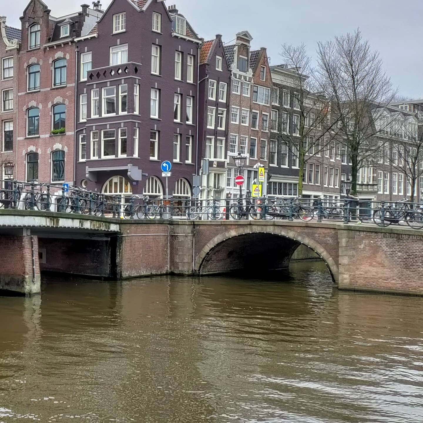
Bridge eleven is another fixed bridge in the centre of Amsterdam. It is located on the western quay of the Singel and spans the Blauwburgwal. This arch bridge is connected with bridge 10, the Lijnbaansbrug, again over the Singel via the quayside. I’m beginning to suspect the bridges without names are a little unloved and unglamourous.
Bridge11 was rebuilt in the shape of the previous bridge and was designed by Wichert Arend de Graaf, an engineer at the Public Works Department who is a little less famous than Piet Kramer.
Architect: Wichert Arend de Graaf
Dienst der Publieke Werken – Public Works Department
Bridge 11: The Quiet Crossing at the Bergstraat
Most visitors who walk this far along the Singel have just come from the Torensluis. They have read the name on Multatuli’s plinth, looked down at the darker cobblestones that trace the ghost of the Jan Roodenpoortstoren, and perhaps lingered over a coffee at one of the terrace tables. When they leave the Torensluis heading north, they cross Bridge 11 without particularly noticing it. That is, in some ways, what makes it worth noticing.
Bridge 11 is officially unnamed. It carries a number, a location on the municipal register, and the same family of material characteristics as its neighbours in the Singel series, but no name has ever been formally attached to it. It sits between the Torensluis’s gravitational pull to the south and the quieter residential stretch of the Singel to the north, doing its work without ceremony. The Bergstraat meets it from the east; the canal belt side opens to the west. It is a crossroads that functions primarily as a threshold: the point where the Singel stops being a tourist destination and starts being a neighbourhood again.
What the Bridge Has Been Called
Because Bridge 11 has no official name, any historical names it carried were informal ones, passed down through neighbourhood use rather than registered in the municipal record. The most natural of these would have been the Bergstraatsluis, a label following the convention of naming a bridge or sluice after the street it serves on the eastern bank. This naming pattern is common throughout Amsterdam’s older bridge stock: the bridge takes on the character of the street that leads to it, and the name circulates in local use without ever achieving the permanence of official registration.
Whether Bridge 11 was also known, at any point, as the Sint Nicolaasbrug is less certain. The area around the Kattengat and the northern Singel had a significant Catholic presence during the period when public Catholic worship was formally suppressed in Amsterdam (from roughly 1578, when the city joined the Protestant revolt, until the restoration of religious freedoms in 1795). Several schuilkerken, the “hidden churches” where Catholic congregations continued to worship behind anonymous facades, operated in the old city’s northern districts during this period. The proximity of Bridge 11 to the Kattengat, and the Kattengat’s historic associations with a concentration of Catholic institutional life, makes the Sint Nicolaasbrug attribution plausible as a neighbourhood name, but no archival record presently available for this post confirms it. The name is worth noting; it cannot, as yet, be confirmed.
In any case, the 2016 municipal policy that retired informal bridge names from common use and consolidated the official register would have applied to any informal name Bridge 11 carried. What remains is the number.
The Mountain Street: Bergstraat and Its Name
The street that meets Bridge 11 from the east has a name that deserves a moment’s consideration. “Berg” means mountain or hill in Dutch; “straat” is street. The Bergstraat is, literally, the hill street or mountain street, which is a curious designation for a city built on peat at or near sea level and conspicuously without any natural hills.
The explanation lies not in topography but in construction process. As Amsterdam’s medieval city developed and its early canals were dug, the excavated earth had to go somewhere. Spoil heaps, mounds of debris from canal-digging and demolition, and the irregular elevated remnants of earlier earthwork formed small but locally significant rises in the urban ground. Streets named for such features crop up throughout the Dutch city-building tradition: the “berg” in a street name usually records not a natural mountain but an artificial or semi-natural elevation that was once prominent enough to serve as a neighbourhood landmark.
In the northern old city, where the Bergstraat winds through the densely built fabric between the Singel and the Kattengat, the original mound or elevation that gave the street its name is long since absorbed into the urban surface. What survives is the name: a record of a moment when the ground here was shaped differently, before centuries of building and compaction smoothed it into the continuous flat plane of the modern city.
From Arched Vault to Flat Deck: The Structural History
The crossing at the Bergstraat has existed in some form since the development of this part of the Singel in the seventeenth century. The first bridge here would have been a timber drawbridge or wooden arch, functional and adjustable, capable of being raised to allow tall-masted vessels to pass through the Singel from the IJ waterfront to the inner canal system.
As the bridge was consolidated into more permanent materials over the eighteenth century, it likely took the form of a middenwelf: an arched bridge with a raised central vault that gave canal traffic clearance while providing a passable surface for foot traffic and handcarts. The middenwelf profile was the standard for Amsterdam’s stone and brick bridges through much of the eighteenth and early nineteenth centuries. Its central hump was functionally necessary when the canal below was still used regularly by vessels with significant mast heights, but it became an increasing inconvenience as wheeled traffic grew and as the canal’s role shifted from working waterway to urban drainage and navigation channel.
The decisive transition came as part of the Dienst der Publieke Werken’s systematic renovation of Amsterdam’s bridge stock in the late nineteenth and early twentieth centuries. The high-arched profile was flattened to a low, level deck: a vaste brug (fixed bridge) that eliminated the drawbridge mechanism and the raised arch simultaneously, producing a surface that wheeled vehicles, trams, and eventually motor traffic could cross without difficulty. This flattening was not an aesthetic choice but a functional one, and it was applied consistently across the Singel series as the city adapted its infrastructure to the demands of the industrial and early modern periods. Bridge 11 received the same treatment, and the flat deck that you cross today is the direct result of those decisions made several generations ago.
The Publieke Werken Design Family
Bridge 11 belongs to the same design family as its neighbours in the Singel series, and the consistency of its material character is one of the things that the Publieke Werken renovation programme deliberately established. The warm-toned brick abutments, the granite nose stones that project at the canal corners to deflect passing vessels, and the wrought iron railings with their geometric patterning are all present here, as they are at Bridges 8, 9, and 10. This consistency was a programmatic decision, not an accident of individual commissions.
The Publieke Werken’s approach to the Singel bridges in the early twentieth century was to treat them as an ensemble rather than as separate structures. Piet Kramer (1881-1961), who designed or oversaw the renovation of the largest number of individual Singel crossings during the 1920s, worked within a framework of shared material and decorative choices that made the series legible as a coherent set even where the details varied from bridge to bridge. Whether Kramer was personally responsible for the design of Bridge 11’s current form, as he was for several immediately adjacent crossings, is not confirmed by the sources available for this post. What is not in doubt is that Bridge 11 sits within that design family, and that its brickwork, granite, and ironwork are products of the same programmatic thinking that shaped the bridges on either side of it.
Walk slowly along the Singel between the Torensluis and Bridge 11 and the consistency becomes apparent: the same height of abutment above the waterline, the same material palette, the same proportion between the bridge deck and the ironwork above it. The Publieke Werken was not building individual bridges; it was constructing a canal.
The Koepelkerk Without the Crowd
The Ronde Lutherse Kerk (Round Lutheran Church), built between 1668 and 1671 by the architect Adriaan Dortsman, stands at Kattengat 2, reached by walking a short distance east from Bridge 11 along the Bergstraat. Its copper dome is one of the Singel’s most distinctive vertical presences, a rounded form that rises above the roofline of the surrounding buildings and, on still water days, produces a near-perfect reflection in the canal surface.
Bridge 10 (the Lijnbaansbrug, one bridge to the south) is the crossing most often cited as the best vantage point for the Koepelkerk reflection shot, and on busy days it can collect a significant concentration of photographers. Bridge 11 offers a slightly different angle on the same subject: the dome appears at a different position relative to the canal’s frame, the water is often quieter here than on the more trafficked stretch to the south, and the number of people competing for the same composition is reliably smaller. For photographers who know to come here rather than to Bridge 10, the crossing at the Bergstraat is a quieter route to what is, in practice, a very similar view.
The Koepelkerk’s history adds its own texture to the approach. The church was built for Amsterdam’s Lutheran congregation, one of the city’s significant Protestant minorities. In 1822 a fire severely damaged the interior; the building was rebuilt with a new dome to replace the original. By the twentieth century the congregation had merged with other Protestant bodies, and the church eventually passed out of active religious use. It is now operated as a conference and concert venue by the Renaissance Amsterdam Hotel, whose main building stands adjacent. The dome remains intact, the copper oxidised to its characteristic green, the reflection as good as it ever was.
A Gateway to the Kattengat
East of Bridge 11, the Bergstraat runs only a short distance before it opens into the Kattengat, a narrow street whose name translates literally as “cat hole” and more idiomatically as a tight or difficult passage. The Kattengat is one of the quieter corners of Amsterdam’s northern old city: small-scale, densely built, with a character that belongs to the working historic fabric of the city rather than to its tourist circuits.
The proximity of Bridge 11 to the Kattengat area also places it near several layers of the old city’s institutional and religious history. The northern Singel and the streets immediately behind it, including the Kattengat, were home during the seventeenth and eighteenth centuries to a variety of religious communities whose legal status was ambiguous or precarious. The schuilkerken (hidden churches) that operated throughout Amsterdam’s old city during the period of the Reformed Church’s dominance were especially concentrated in areas like this, where dense building and irregular street patterns provided cover for congregations that worshipped without official sanction. Whether a specific Catholic schuilkerk operated close enough to Bridge 11 to have given it a saint’s name in local parlance is, as noted above, a question that the available records do not resolve.
What the Kattengat and the Bergstraat do provide is a sense of the northern Singel’s character north of the Torensluis: quieter than the tourist circuits, more residential in scale, with the Koepelkerk dome appearing above the roofline as a reminder that this part of the city was, in its own time, a significant centre of civic and religious life.
Heritage Status and the Fabric of the Bridge
Bridge 11 is among the Singel bridges designated as a gemeentelijk monument (municipal protected monument) under the bulk designation of 72 Singel bridges recorded on 10 October 1995. This designation covers the physical fabric of the bridge: the brick abutments, granite corner stones, wrought iron railings, and general proportions are all protected from alteration under the monument registration.
The bridge is a fixed structure of brick, granite trim, and steel, consistent with the material specification of the renovated Singel series. No major structural intervention at Bridge 11 beyond routine maintenance has been publicly documented in the sources available for this post. The material condition of the bridge reflects the ongoing programme of inspection and upkeep that the municipality applies to the protected bridge stock, with periodic repair and repointing of the masonry and maintenance of the ironwork.
The Bridge That Does Not Ask for Attention
There is a particular kind of urban infrastructure that does its work entirely without drama, and Bridge 11 is an example of it. It is not the oldest, widest, or most architecturally elaborate bridge in the Singel series. It has no known literary associations, no documented connection to a welfare institution or an industrial process, no particularly complex naming history. What it has is position: the crossing where the Singel transitions from the dense historical significance of the Torensluis zone into something quieter and more residential.
That transition is itself historically interesting. The Torensluis, with its medieval tower footprint and its bronze writer, carries centuries of accumulated meaning. Bridge 11, a few minutes’ walk to the north, carries the same design vocabulary in brick and granite and iron, but without the interpretive weight. It is what most of Amsterdam’s bridges actually are: a specific solution to a specific need, built to a shared standard, maintained in the fabric of a city that has been continuously inhabited and continuously adapted for seven centuries.
Walk across it on a morning when the water is still and the dome of the Koepelkerk floats in the Singel below. The reflection will be there, and the city will be going about its business around you, and the bridge will be doing precisely what it was built to do.
Sources: Municipality of Amsterdam, gemeentelijk monument designation records, 10 October 1995 (72 Singel bridges); Stadsarchief Amsterdam, bridge register and historical maps of the northern Singel (17th-19th century); Dienst der Publieke Werken, bridge renovation records, Singel series (late 19th and early 20th century); Adriaan Dortsman, architectural documentation of the Ronde Lutherse Kerk, 1668-1671 (Stadsarchief Amsterdam); J. Baggeler and R. van Schaik, Piet Kramer. Bruggenbouwer van de Amsterdamse School (Amsterdam, 2016); informal name retirement records, Municipality of Amsterdam, 5 July 2016; historical records of schuilkerken in Amsterdam’s northern old city (Stadsarchief Amsterdam, Kattengat / Bergstraat district).
Key Facts at a Glance
| Official name | None (unnamed) |
| Possible historical names | Bergstraatsluis (informal, after the street); Sint Nicolaasbrug (proposed, not confirmed in available records) |
| Bridge number | 11 |
| Location | Singel, at Bergstraat |
| Heritage status | Gemeentelijk monument (municipal protected monument), designation 10 October 1995 |
| Type | Fixed bridge (vaste brug), brick, granite, and steel |
| Bergstraat etymology | Named for a small hill or debris mound (“berg”) from early canal excavation; no natural elevation exists today |
| Historical bridge type | Likely a middenwelf (arched vault bridge) before renovation; flattened to flat deck for modern wheeled traffic |
| Design family | Publieke Werken renovation series; Amsterdam School material vocabulary; consistent with Bridges 8-10 |
| Koepelkerk view | Ronde Lutherse Kerk dome (Kattengat 2, built 1668-1671, architect Adriaan Dortsman) visible and reflected in the Singel; quieter photography vantage than Bridge 10 |
| Kattengat access | Short walk east via the Bergstraat; historical concentration of schuilkerken (hidden churches) in the district |
| Position in series | Between Bridge 10 (Lijnbaansbrug) to the south and Bridge 12 to the north; transitional zone between Torensluis tourist circuit and quieter northern Singel |
| Bridge to the south | Bridge 10 (Lijnbaansbrug, at Blauwburgwal) |
.jpg/1200px-2022_Brug_11%2C_Asd-zijaanzicht_(2).jpg)
Bridge 11 is located in the western quay of the Singel and spans the Blauwburgwal. Via the quayside, the vault bridge is in direct contact with bridge 10, the Lijnbaansbrug,
https://w3w.co/pops.swam.pepper
https://w3w.co/tandarts.schelpen.gedut
///pops.swam.pepper
///tandarts.schelpen.gedut
52.376415, 4.891061
This what3words address refers to a 3 metre square location. Tap the link or enter the 3 words into the free what3words app to find it.
Bridge 11 has no no official name.
Both bridge 10 and bridge 11 have been there for centuries just like many of the other bridges we have covered so far. Pieter Bast drew both bridges on his map of the city in 1599. Bridge 10 over the ‘Cingel’ is drawn as a drawbridge, bridge 11 over the ‘Blaeuwe Burchwal’ as a fixed bridge. Balthasar Florisz. van Berckenrode also drew both bridges on his map of 1625. Bridge 10 is many times larger than bridge 11.
The modern history of this bridge begins in 1894. In 1893, a request was made to renew this bridge due to its poor condition. The municipal council did not agree. A new investigation was then carried out due to the collapse of a bridge elsewhere, for which renewal had been requested at the same time, and which was also rejected. Bridge 11 was renewed in 1915, when a contractor saw an opportunity to build a new bridge for 21,000 guilders (the currency the netherlands used before the Euro) within eight months. The bridge, in the shape of the old one, was designed by Wichert Arend de Graaf , engineer at the Public Works Department. He had already designed a bridge with a span of reinforced concrete, hidden from view by a combination of granite and brick. The bridge itself is 54 metres long with wings, while the visible bridge (passage) is only six metres wide at the water line, less above it of course because of the arch. The bridge is slightly constricted in relation to the quay.
Since then, the bridge has remained unchanged, although repairs to the quay walls are visible.
Brug 11 een brug zonder naam
Architect: Wichert Arend de Graaf
Dienst der Publieke Werken – Department of Public Works


