
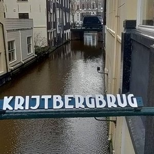
Bridge number 3 (Brug Drie) Krijtbergbrug sometimes called sluis instead of brug (Sluis originally or is still a lock) (Brug No. 3) Bridge No. 3
Named after the neighbouring Krijtberg or Sint Franciscus Xavieruskerk on the Singel. The church dates from 1883 and took the place of the former secret church in the Crijtberg house, which served the Jesuits.
The Paradox of the Hidden Bridge
There is a particular irony attached to Bridge 3 that rewards a moment’s contemplation before you cross it. The bridge carries the name of a church that was, for more than two centuries, legally required to be invisible. The Krijtberg, the Jesuit Catholic church whose twin Neo-Gothic towers rise just south of the bridge on the western bank of the Singel, spent its first two hundred years behind closed doors, tucked into the back rooms of a private merchant house, accessible only through an alley that most of the city’s inhabitants walked past without knowing what lay beyond it. It was, by design and by law, a hidden thing.
The bridge named after it now sits at one of the most open and observed points on the inner Singel: a broad, fixed crossing at the mouth of the Beulingsloot, flanked on both sides by designated heritage buildings and straddled daily by tourists, students, cyclists, and residents moving between the Negen Straatjes and the Begijnhof. You can see the church towers from the bridge deck. You can read the name on the parapet. The hidden church has, through the passage of three and a half centuries, become one of the most legible landmarks on the canal.
This is the particular story of Bridge 3: a crossing named for concealment, now famous for openness.
The House That Named Everything: De Crijtbergh on the Singel
Every word in the bridge’s name has a history, and all of those histories begin with a house.
In the early seventeenth century, a merchant’s property on the Singel bore the name “De Crijtbergh,” meaning “The Chalk Mountain.” The name was almost certainly a reference to the chalk cliffs of southern England, possibly the white cliffs visible from the sea lanes that Dutch merchant vessels used in the English trade. House names in Amsterdam’s Golden Age often referenced places or goods connected to the owner’s commercial activity, and “chalk” was a traded commodity in the period.
The house at De Crijtbergh, located at what is now Singel 446, came into the possession of the Jesuits in 1654, when the priest Pieter Laurensz (or Petrus Laurentius, born in Antwerp in 1588) purchased three houses on the Singel. In the back rooms of the largest of these, he converted the space into a house church: a place of worship for Amsterdam’s Catholic faithful, gathered under the patronage of Saint Francis Xavier.
This was not a legal act in the sense of occupying a licensed religious building. It was, rather, a careful and officially tolerated evasion. The practice of Catholicism had been banned in Amsterdam since 1578, when the Protestants replaced the Catholic city government in the event known as the Alteratie (the Alteration). From that year, Catholic churches were confiscated, repurposed, and handed over to the Dutch Reformed church. A subsequent law of 1581 forbade all Catholic religious gatherings and any public expression of the Catholic faith. The penalty for violation was, initially, fines; eventually, confiscation of property followed.
The city’s response to Catholicism was complicated by the practical reality that a large portion of Amsterdam’s citizens remained Catholic after 1578. The solution was a tacit toleration of “hidden churches” (schuilkerken) provided they were genuinely hidden: no external signs, no bells, no visible congregation assembling in the street. The authorities would not actively seek them out. But neither would they formally acknowledge their existence.
De Crijtbergh’s house church functioned in this carefully maintained grey zone from 1654. The congregation grew so rapidly that in 1677 a larger gallery church was built at the same site, comparable in scale to other hidden churches of the period, accessible via an alley between the Singel houses. In 1835 the two front houses were demolished and replaced by the current rectory building, at which point the church became accessible through an internal corridor in the building rather than an external alleyway. But it remained, in formal terms, a private religious institution on private property.
The name “De Crijtbergh” attached itself to the church in all these successive forms. A property name from a merchant’s house became the identifier for a clandestine congregation, then for a legal church, then for a bridge. It is, in this small way, one of Amsterdam’s most complete etymological journeys: chalk cliffs in the English Channel encoded in a canal bridge in the innermost part of the grachtengordel.
1853, 1881, 1883: The Church Comes Out
The legal prohibition on Catholic public worship in the Netherlands lasted until the restoration of the episcopal hierarchy in 1853. When that restoration came, after two and a half centuries of the schuilkerk system, it represented an almost immediate unleashing of architectural ambition: Catholic congregations across the Netherlands began planning and building churches that were, for the first time in generations, designed to be seen.
At De Krijtberg, the implications of the change were significant. The Jesuit community at Singel 446 had a hidden church that was adequate for private worship but architecturally modest by design. When planning began for a replacement that would stand publicly on the Singel, the constraints of the site were formidable: the land available was narrow and hemmed in on three sides by existing houses. Whatever was built here would have to make its vertical statement with minimal horizontal footprint.
The commission went to Alfred Tepe (1840-1920), a Amsterdam-born architect who had trained partly in Germany and was involved in the restoration of Cologne Cathedral. Tepe was the leading architect of the Guild of Saint Bernulph in Utrecht, the Catholic architectural organisation that positioned itself as a rival to the Cuypers school, and his design sensibility was shaped by German Gothic rather than French Gothic sources. He was awarded the contract to construct, within a severely restricted site, “a church with two stair towers and among others, two chapels, a sacristy and stairhead.”
What Tepe produced, in the years of construction between 1881 and 1883, was a church whose principal architectural device was height. Unable to expand sideways on the confined site, he drove the building upward, designing a three-aisled basilica with an unusually tall nave, internal galleries on both sides, and a facade organised around two narrow pointed towers. The towers are the church’s most immediately recognisable feature: slim, vertical, Neo-Gothic, and built from single-colour baked masonry in crossbond. Their wrought iron pinnacles and decorative roofwork add further vertical emphasis to a facade that seems to reach for whatever sky the Amsterdam streetscape allows.
De Krijtberg was consecrated on 3 December 1883. The interior is a deliberate contrast to the spare exterior: Tepe designed the church to hold the exuberant decorative programme that studios including those of Friedrich Wilhelm Mengelberg provided, including a gilded ciborium, triumph bar, altar of Our Lady, Jesuit saint statues, a Pieta, and stations of the Cross. Objects carried over from the schuilkerk era include an eighteenth-century Baroque statue of the Immaculate Conception and a sixteenth-century polychrome wooden statue of the Virgin Mary, both retained from the older hidden church. The church that appears to its neighbours as an exercise in Gothic restraint announces itself on the inside as a total work of art.
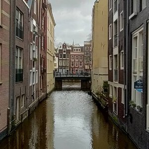
The effect on the Singel was immediate and lasting. Where there had been a private house with a church invisible behind it, there was now a pair of towers that changed the skyline of this stretch of the canal permanently. Viewed from the south, from the direction of the Muntplein, the towers punctuate the perspective of the Singel in a way that no building had done here before. Viewed from Bridge 3, looking south from the bridge deck, the towers frame the view down the canal with an authority that the schuilkerk it replaced could never have contemplated.
The Bridge and Its Canal: Crossing the Beulingsloot
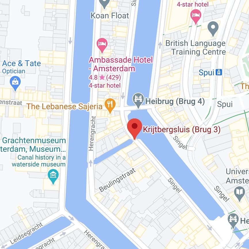
The Krijtbergbrug does not cross the Singel itself. It crosses the Beulingsloot, the short cut in the western bank of the Singel that creates a small island between the canal and the surrounding streets. The Beulingsloot is one of the shortest canals in Amsterdam: at approximately fifty metres in length, it connects the Singel to the Herengracht in a direct cut dug around 1600, during the period of Amsterdam’s major canal belt expansion. Unlike most of the city’s canals, the Beulingsloot has no quays: its banks are formed directly by the walls of the buildings that face it, without any intervening walkway. Every building that backs onto the Beulingsloot is a designated municipal or national monument.
The bridge is already visible on Joan Blaeu’s map of Amsterdam from around 1649, making it one of the documented bridges on the inner Singel with a cartographic record stretching back more than three and a half centuries. It also appears on the earlier city plan of Pieter Bast, from around 1599. In these early maps it is shown as a crossing at the southwest quay of the Singel, in a location that already shows the spatial logic that makes it necessary: without a bridge here, the island formed by the Beulingsloot would require a lengthy detour to cross.
The bridge is located between the addresses Singel 424 and Singel 426, both of which are municipal monuments, and directly adjacent to the Krijtberg Church, which is a national monument (rijksmonument).
Two Near-Misses: The Plans That Would Have Erased the Bridge
Like several of its neighbours along the Singel, the Krijtbergbrug survived the twentieth century partly through the failure of ambitious plans that would have made it redundant.
The first threat came from proposals for a new radial road running southwest from the city centre. Under this plan, the Beulingsloot itself would have been filled in, removing the need for any bridge at this location. The proposals were part of the broader early twentieth-century project of rationalising Amsterdam’s traffic routes, in which several canals were considered for elimination in the interest of creating wider, faster arterial connections. In this instance, the municipality ultimately chose the Leidsestraat as the preferred southwest arterial route, and the Beulingsloot survived.
The second threat came in 1920, when the municipality considered establishing the headquarters of De Nederlandsche Bank on the site. The scale of such a development would have required significant clearance of the surrounding fabric, potentially including the bridge and the canal it crosses. That proposal also came to nothing.
The Beulingsloot itself faced additional pressure in the 1910s and 1920s, when there were broader plans to fill in the entire short canal and carry out what the sources describe as “drastic demolitions” in the area. These plans were not pursued. In the century that has passed since, the idea of filling in the Beulingsloot has not been seriously revisited, and the area it defines, including Bridge 3, is now comprehensively protected under Amsterdam’s heritage regulations.
The 1904 Widening and the Character of the Current Bridge
The early twentieth century was a period of transformation for Amsterdam’s inner-city bridges. The expansion of the electric tram network from 1904 onward placed new loads on existing crossings, and the general intensification of urban traffic throughout the preceding decades had already made many of the older, narrower bridges inadequate for the volume of movement they were asked to carry. The Dienst der Publieke Werken (Public Works Department) oversaw a systematic programme of bridge renovation and widening across the city, with its bridge division formally reorganised and expanded in 1904 to meet these demands.
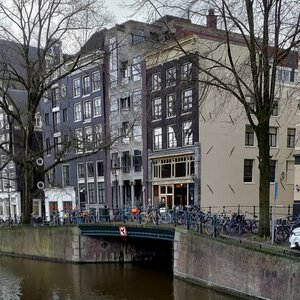
The Krijtbergbrug was renovated as part of this programme in 1904, and the renovation resulted in the notably wide crossing that still exists today. The bridge is described as “exceptionally wide,” a description that holds up to observation: standing on the bridge deck, it has the lateral breadth of a small square rather than a conventional canal crossing, and the generous space it provides for pedestrian movement on both sides of the central roadway is apparent. The widening was driven by the specific traffic demands of this location, where the bridge forms the connection point between the Heisteeg and the Begijnesteeg, and where movement between the Singel and the streets to the west had been increasing steadily.
The current fixed bridge reflects the design vocabulary characteristic of the Publieke Werken’s early twentieth-century bridge programme. The department worked in the period immediately before and during the emergence of the Amsterdam School, and the influence of that movement is legible in the bridge’s design details. The characteristic elements to look for are: the warm-toned brick of the abutments and parapet structures, the granite trim used for the coping stones and edge details, and the wrought iron railings, whose proportions and form reflect the organicist sensibility that Piet Kramer and his colleagues brought to the city’s infrastructure in this period.
Whether Bridge 3’s specific railing design is directly attributable to Kramer, to the broader Publieke Werken style, or to an earlier renovation that preceded Kramer’s influence on the department is a question that the publicly available record does not resolve with certainty. What can be said is that the bridge sits within the visual and historical frame of exactly the kind of modest, well-crafted urban infrastructure that the early Amsterdam School architects regarded as their domain: not monumental, not invisible, but attentive and considered.
The Schuilkerk Paradox in Reverse
One of the most pleasurable things about Bridge 3’s position on the Singel is what it allows you to see, and what the seeing implies about the history of the place.
From the bridge deck, looking south, the twin towers of De Krijtberg dominate the near view. Tepe’s slim Neo-Gothic facade rises above the canal houses on either side, its pinnacles and wrought-iron roofwork catching the sky. The church that spent two centuries hiding behind a merchant’s house front is now the most conspicuous building in this section of the Singel, visible from two bridges away and clearly identifiable at street level in a way that its predecessor was designed specifically not to be.
The bridge named after the church sits, in turn, at one of the more exposed points on the inner canal. There are no arches overhead, no tunnel beneath, no alley to turn down. The bridge deck is wide, open, and unobstructed. The visitor arriving at Bridge 3 from the north, from the Muntplein direction, sees the church before they reach the bridge. The visitor crossing the bridge looks directly at the church. The visitor leaving the bridge and walking south passes the church at close range on their left.
For a name that began in concealment, it has ended up in a very exposed position.
Looking South Toward Bridge 2: A View Worth Noting
From Bridge 3, the view southward along the Singel toward the Heiligewegsluis (Bridge 2) offers one of the more striking visual contrasts on this stretch of the canal. Bridge 2, which carries tram lines 2 and 12 across the Singel at the Heiligeweg, is itself a substantial structure, more than forty-five metres wide at its broadest point. But from the vantage of Bridge 3, what registers most clearly is the narrowness of the Singel between the two crossings, the water compressed between the canal houses on both banks in a perspective that makes the width of Bridge 3 itself seem even more remarkable by comparison.
This contrast, the relative slimness of the canal versus the exceptional breadth of the bridge, is characteristic of the inner Singel and explains something about why the widening of 1904 was considered necessary. The Singel at this point is not a wide canal: it is an intimate, close-banked waterway through which the bridges must pass much of the city’s east-west pedestrian and cyclist movement. A narrow bridge here would create a bottleneck; the wide bridge, inherited from the 1904 renovation, distributes that movement effectively.
The Bridge as Threshold: Toward the Begijnhof
The most common reason that visitors cross Bridge 3 today is not to see the bridge, and not specifically to see the Krijtberg Church. It is to reach the Begijnhof.
The Begijnhof, Amsterdam’s medieval beguinage courtyard, is one of the city’s most consistently surprising urban experiences: a quiet, grass-centred enclosure surrounded by historic houses, churches, and a profound sense of separation from the canal city immediately outside its walls. It is, in this respect, a spiritual descendant of the schuilkerk tradition: a place that keeps its interior life out of view from the street, accessible only through modest doors that casual passers-by routinely walk past without noticing.
The Begijnhof has two entrances. The better-known is on the Spui, the square to the southeast. The quieter and in some ways more characterful approach is from the Gedempte Begijnensloot, the street that follows the line of the old Begijnensloot canal, filled in 1865, which originally encircled the beguinage with water. The Gedempte Begijnensloot entrance is reached, from the Singel, by crossing Bridge 3 and walking a short distance east.
The Begijnensloot and the Beulingsloot were once connected elements of the same waterway system that defined this part of the medieval city. The filling in of the Begijnensloot in 1865 is what created the Gedempte Begijnensloot street; the Spui, also originally a body of water, was filled in 1882 and became the square it is today. Bridge 3, crossing the Beulingsloot above a canal that has survived while its neighbours were eliminated, carries pedestrians from the Singel into a neighbourhood that has been progressively losing its waterways for a century and a half, and toward a courtyard that has retained its character precisely by making itself difficult to find.
Most visitors crossing Bridge 3 to reach the Begijnhof do not know they are doing this. They are making a journey from one formerly hidden thing, a bridge named after a church that concealed itself for two centuries, to another, a courtyard that has always offered itself modestly to anyone patient enough to find the door.
The Modern Bridge: Heavy Traffic, Quiet Materials
The Krijtbergbrug today carries the weight of the Negen Straatjes. The Nine Streets shopping district, which begins immediately to the west of this bridge at the Wijde Heisteeg and runs north through nine short alleys to the Raadhuisstraat, generates some of the most concentrated pedestrian movement in Amsterdam’s city centre. Visitors arriving from the Singel on foot, or leaving the Nine Streets eastward toward the Kalverstraat or the Rokin, cross Bridge 3 in numbers that would have been unimaginable when the bridge was first documented on Pieter Bast’s map in 1599.
The bridge surface handles this traffic in the practical and slightly unremarkable way that a well-maintained fixed urban crossing should: the deck is flat, the footing is consistent, and the approach from both banks is easy. The width that the 1904 renovation provided is, in this modern context, genuinely useful: the bridge is wide enough for pedestrian flows in both directions without the compressed, single-file compression that narrower crossings impose. Maintenance and resurfacing of the bridge deck have been carried out at intervals consistent with Amsterdam’s general bridge upkeep programme, which covers the city’s approximately 1,900 bridges under a rolling inspection and renewal schedule. No major structural intervention or formal reprofiling has been publicly documented for Bridge 3 in the recent period.
The bridge is flanked on both sides by its heritage context: monuments at Singel 424 and Singel 426, the national monument of the Krijtberg Church to the south, and the protected fabric of the Beulingsloot buildings behind it. In this company, the bridge reads as an appropriately modest object: it does not announce itself, does not demand the eye, and does not compete with its neighbours for attention. It simply provides the crossing, as it has done since at least 1599, and lets the name on its parapet carry the longer story.
Research compiled February/March 2026. Principal sources consulted include: the Krijtbergsluis Wikipedia article (nl.wikipedia.org/wiki/Krijtbergsluis); the Beulingsloot Wikipedia article (nl.wikipedia.org/wiki/Beulingsloot); the De Krijtberg English Wikipedia article (en.wikipedia.org/wiki/De_Krijtberg); the De Krijtberg official history page (krijtberg.nl/en/history); De Krijtberg architectural documentation (arcam.nl/architectuur-gids/de-krijtberg); the Amsterdam School Wikipedia article and associated architectural documentation; the Begijnhof Amsterdam Wikipedia article (en.wikipedia.org/wiki/Begijnhof,_Amsterdam); the Bridges of Amsterdam archive (bridges.cramberts.com); and the Bruggen van Amsterdam reference (bruggenvanamsterdam.nl/singel_bij_beulingsloot.htm). For primary documents on the 1904 Public Works renovation and precise structural specifications, the Stadsarchief Amsterdam (stadsarchief.amsterdam.nl) holds the relevant records under Gemeentewerken classifications for the Singel bridges.
Key Facts at a Glance
Official name: Krijtbergbrug (also known as Krijtbergsluis) Bridge number: 3 (Brug 3) Location: Southwest quay of the Singel, spanning the Beulingsloot Connects: Heisteeg (south approach) and Begijnesteeg (north approach) Type: Fixed bridge Notable width: Exceptionally wide, functioning closer to a small square than a conventional bridge deck; widened in 1904 renovation
Etymology (full chain):
- English chalk trade routes (“Chalk Mountain”) give the name to a merchant house: De Crijtbergh, Singel 446
- In 1654, Jesuit priest Pieter Laurensz converts the back rooms of De Crijtbergh into a hidden Catholic church (schuilkerk)
- In 1677, a larger gallery church replaces the original house church, still known as De Krijtberg
- In 1835, the front houses are replaced by a rectory; the church access moves indoors
- After the 1853 restoration of the Dutch episcopal hierarchy, planning begins for a public church
- In 1881-1883, Alfred Tepe (1840-1920) designs and builds the current Neo-Gothic Sint Franciscus Xaveriuskerk (De Krijtberg); consecrated 3 December 1883
- The bridge at the adjacent Beulingsloot takes the name Krijtbergbrug
Earliest cartographic evidence: Pieter Bast’s Amsterdam map, ca. 1599; Joan Blaeu’s map, ca. 1649 1904: Widened and renovated by the Dienst der Publieke Werken (Public Works Department) Design elements: Warm-tone brick abutments; granite coping trim; wrought iron railings in early Amsterdam School idiom Survival threats: Plans for a southwest radial road (Beulingsloot to be filled in); De Nederlandsche Bank headquarters proposal (1920); plans to fill in the Beulingsloot (1910s-1920s): all abandoned Heritage status: Flanked by Singel 424 and 426 (municipal monuments); adjacent to De Krijtberg (national monument / rijksmonument) Beulingsloot: Approximately 50 metres in length; one of Amsterdam’s shortest canals; dug ca. 1600; no quays (canal walls formed directly by building walls); connects Singel to Herengracht Modern role: Primary pedestrian and cyclist crossing linking the Singel to the Negen Straatjes (west) and the Begijnhof approach via Gedempte Begijnensloot (east/south) View southward: Twin Neo-Gothic towers of De Krijtberg (Alfred Tepe, 1883) immediately visible; Heiligewegsluis (Bridge 2) further south along the Singel Visitor note: The Begijnhof, one of Amsterdam’s most visited medieval courtyards, is reached from Bridge 3 by crossing west and walking south to the Gedempte Begijnensloot entrance; the courtyard is free, open daily 8am-5pm, and silence is requested inside
More at https://nl.wikipedia.org/wiki/Krijtbergsluis
Bridge number 3 (Brug Drie) Krijtbergbrug sometimes known as Krijtbergsluis on the map
The bridge, which lies between Singel 424 and Singel 426 (both municipal monuments) is named after an earlier version of the Krijtbergkerk, a national monument. Another name for the bridge is the Rijtjesbrug, after Rijtjeskerk, the nickname of De Krijtberg.
https://w3w.co/wooden.ruin.fighters
https://w3w.co/printje.stichter.groef
///wooden.ruin.fighters
///printje.stichter.groef
52.36841, 4.887778
This what3words address refers to a 3 metre square location. Tap the link or enter the 3 words into the free what3words app to find it.

There has been a bridge here at the location of Krijtbergbrug for centuries, because Joan Blaeu‘s map from around 1649 already shows the bridge in this location, as well as the buildings on the Beulingsloot directly on the water. However, the bridge was almost lost, because in the plans of the municipality of Amsterdam for a radial road to the southwest, the “ditch” was almost filled in and the bridge would have become pointless and been removed also. However, the Leidsestraat was chosen as the exit road instead.
In 1920 though, the bridge was in danger of being removed again: the municipality wanted the headquarters of De Nederlandsche Bank to be built here, but once again it remained as the plans were changed.

