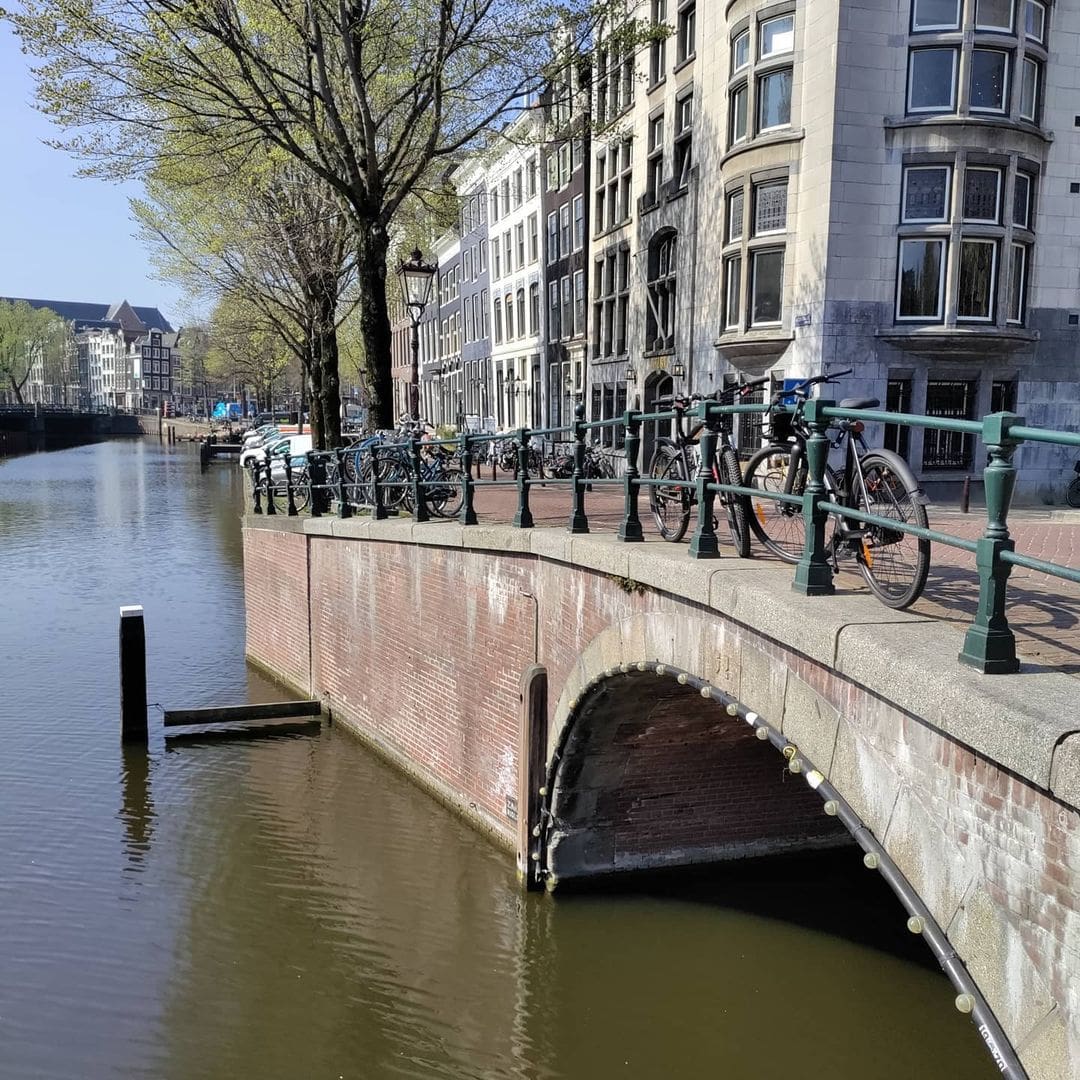
Bridge 52 (Brug tweeenvijftig)
Remaining on the Keisersgracht and the junction with Leliegracht to continue our journey. Road bridge 52 is located on the northern quay of the Leliegracht spanning the Keizersgracht. It is flanked by #bridge51 (adjoining) and #bridge53 (on the opposite side of Keizersgracht), spanning the Keizersgracht and the Leliegracht.
All three bridges are fake antique as they were rebuilt in the early 1980’s along with the previous bridges along the #keisersgracht and whilst you can’t see it from my pictures numbers 52 (east side) and 1982 (west side) can be read on two stones.


The Other Bridge on the Corner
Most visitors who stop at the junction of the Keizersgracht and the Leliegracht are looking the wrong way. They turn eastward to admire the broad sweep of the Emperor’s Canal, or they tilt their heads upward to frame the Westertoren in a photograph. Almost nobody lingers to examine the bridge on the western quay, the one on the Jordaan side, the crossing that connects the northern bank of the Leliegracht with the open water of the Keizersgracht and which bears, in a stone quietly embedded in its parapet, the number 52.
Bridge 52 is not a famous bridge. It has no official proper name in the municipal register. It carries no trams. It appeared in no celebrated Pieter Oosterhuis painting, nor in the dramatic cityscape canvases that adorned the walls of Golden Age merchant houses. Yet Brug 52 is, in its specific way, one of the most historically layered crossings in the entire canal ring. It is the bridge that stands directly in front of one of Amsterdam’s most controversial early skyscrapers, beside the ghost of a 400-year-old hydraulic lock, and in the immediate line of sight of one of the city’s most reproduced church towers. And it is a bridge with a secret, one encoded in its own stonework and confessed quietly to anyone who knows where to look.
Position and Geography: The Western Quay
To understand where Bridge 52 sits, it helps to understand the geometry of the Keizersgracht-Leliegracht junction. The Leliegracht, the “Lily Canal,” crosses the Keizersgracht at roughly a right angle, connecting the broader canal belt waterway with the Prinsengracht at the far western end. At this crossing, the Keizersgracht is flanked by three bridges, numbered by the Public Works Department in sequence. Bridge 51 spans the Keizersgracht itself, crossing the canal from the Westermarkt side to the Jordaan side. Bridge 52 sits on the western (Jordaan-facing) quay of the Keizersgracht, spanning the mouth of the Leliegracht as it opens onto the larger canal. Bridge 53 occupies the equivalent position on the eastern quay. Together, these three fixed crossings form a small trinity of masonry and concrete at one of the most photographed canal intersections in Amsterdam, and Bridge 52 is the westernmost member of that group.
Bridge 52 is located in the western quay of the Keizersgracht and spans the Leliegracht. Seen from the centre, just behind this bridge is the Leliesluis. That parenthetical detail about the Leliesluis, the “Lily Lock,” is not incidental. It is the key to understanding why this particular location has mattered so much, for so long, to the hydraulic functioning of the city.
The Etymology of Lily and Lock: A Name with Two Meanings
The name context of Bridge 52 is inseparable from the name contexts of the Leliegracht and the Leliesluis, and they deserve careful untangling because they intersect in an unusually complicated way.
The Leliegracht, as noted in the post on Bridge 51, takes its name from the Oude Leliestraat, documented as early as 1560, which in turn drew its name from the house “In de Witte Lelye” (In the White Lily) that stood beside the Singel near the Torensluis. The floral name fits the Jordaan tradition: the neighbourhood’s streets and canals were named for flowers and plants, possibly reflecting the green, garden-character of the area during its earliest phases of development, and possibly deriving from the French word “jardin” (garden), which may lie behind the name Jordaan itself.
The Leliesluis, literally “Lily Lock,” complicates matters further. In early modern Amsterdam, the word “sluis” did not mean only what it means today (a lock, or a sluice gate). It has been centuries since the Leliesluis was called a bridge. Literally a ‘sluis’ is a ‘lock’ to guide water but in the old days a ‘sluis’ was also a name for a ‘stone bridge.’ So when 17th-century Amsterdammers spoke of the Leliesluis, they might have meant the stone bridge at the Prinsengracht end of the Leliegracht, or the hydraulic lock mechanism there, or both at once, and the confusion was genuine even in contemporary records.
What is historically clear is the hydraulic function of this lock. De oorspronkelijke Leliesluis in de Leliegracht was al rond 1614 aangelegd om het water in Keizersgracht, Herengracht, Singel en de oude stad te scheiden van het water in Prinsengracht en de latere Jordaan, waar het peil een stuk lager was. In plain terms: from around 1614, even before the Keizersgracht was fully dug, a lock at the Prinsengracht end of the Leliegracht separated the higher-level water of the city canals from the lower-level water of the Jordaan polder canals. The Leliegracht was built to maintain the higher city water level on one side and the lower polder level on the other, a hydraulic distinction that shaped the very existence and character of the canal. The Leliesluis, in this sense, is where the city’s water management philosophy was written in stone.
Bridge 52, as the crossing at the Keizersgracht mouth of this same Leliegracht, sat at the other end of this hydraulic corridor, marking the canal’s entry into the broader canal ring system. It was not a lock-bridge itself, but it was the gateway at which the Lily Canal met the Emperor’s Canal, and everything that moved through one to reach the other passed over or under Bridge 52.
A Bridge in Antiquity: The Cartographic Evidence
The documentary evidence for a bridge at this exact location is older than the Keizersgracht itself. On the map of Balthasar Florisz. van Berckenrode from 1625, a bridge with three passages is drawn over the Lely Graft in the Keysers Graft with the Lely Sluys behind it. However, the map with the plot division south of the Leliegracht between Keizersgracht and Prinsengracht from around 1618 also showed a bridge (five arches). Joan Blaeu, however, drew a bridge with one passage on his 1649 map.
These three 17th-century cartographic depictions tell a story of flux: the bridge in 1618 had five arches, by 1625 it had three passages, and by 1649 it had been consolidated to a single span. This sequence likely reflects the early instability of foundations in this corner of the city, the ongoing experiments with pile-driven bases in Amsterdam’s notoriously soft subsoil, and the gradual rationalisation of the junction as the canal belt was built out and stabilised. A five-arch bridge, built while the lots on either side of the Leliegracht were barely complete (the map dating to around 1618, when the Keizersgracht allotments to the north had only just been fully assigned), was an ambitious and perhaps premature structure. The reduction to a single passage by the time of the Blaeu map suggests either a dramatic narrowing of the waterway, a comprehensive rebuild, or both.
The Leliesluis also has its own catastrophic history nearby. At the Prinsengracht end of the Leliegracht (at what is now Bridge 61, the Leliesluis), a three-arched stone bridge collapsed on 14 May 1659, killing seven or eight people. The collapse was recorded in Isaac Commelin’s Beschrijvinge van Amsterdam of 1691, which noted the bridge was rebuilt immediately on five arches, such was the importance of this transverse route to the city’s movement. Although this disaster struck at the Prinsengracht crossing, not at Bridge 52’s location, it illustrates the fragility of early masonry construction at this hydraulically complex stretch of the Leliegracht corridor, and explains the municipal wariness about the entire junction’s structural stability that would persist into the 19th century.
What Jacob Olie Saw: The 1896 Revelation
The history of Bridge 52 takes a distinctly unusual turn when the archive photographs are consulted, and here the bridge diverges sharply from its immediate neighbour, Bridge 51.
Although in the 21st century there is a bridge with a passage, Jacob Olie recorded a bridge with three passages and without arches in 1896, and a postcard from 1904 showed the same image.
This is a remarkable piece of evidence. Jacob Olie, the Amsterdam photographer and architectural draughtsman who produced roughly 5,000 glass-plate photographs of the city between 1861 and his death in 1905, captured Bridge 52 in 1896 in a form that contradicts what the current bridge’s stone facing would suggest. The structure Olie photographed was not a graceful arched wulfbrug at all. It was a flat, utilitarian crossing with three separate passages and, critically, no arches. This is consistent with what happened to many canal-belt bridges in the 1880s and 1890s: the high-arched masonry vaults were dismantled and replaced with low-profile iron girder bridges that could accommodate the level decks needed for horse-drawn trams and heavy commercial wagons. The three-passage arrangement Olie recorded suggests a bridge with two intermediate piers dividing the canal mouth into three openings, a form more common to wide, multi-span crossings than to the single-arch wulfbrug type.
The 1892 joint tender that lowered and reconstructed bridges 51, 52, and 53 together is the likely moment when Bridge 52 acquired this three-passage girder form. The 1892 bridge was, in other words, an openly modern, flat iron structure, not a historicising one. And the same postcard evidence from 1904 confirms this flat profile was still in place at the turn of the century, when the adjacent Astoria building was under construction.
This creates an important distinction between Bridge 52 and Bridge 51. Bridge 51, whose 1864 reconstruction specifications mention a “stone Wulf bridge” by name, appears to have retained at least an arch profile longer. Bridge 52 had been modernised more completely by 1896 into a purely functional three-passage flat bridge. Both were then, in the early 1980s, given their current historic-looking stone-clad arch appearance. The arch form of Bridge 52’s current exterior is therefore not a restoration of what stood here in 1892. It is a new design, wrapped in old stones, that gives this bridge an appearance it never previously had in the post-medieval era.
The Beautiful Lie, Mark II: The 1979 to 1982 Reconstruction
Bridge 52 underwent its current major reconstruction as part of the same campaign that transformed its siblings. In 1892 a new tender took place and the three bridges (51, 52, and 53) had to be lowered. It was not until almost a century later that there was work to be done again from 1979 to mid-1982, when the bridge complex was under construction. The stones were pre-numbered to make the work go smoothly. Bridge numbers 52 (east side) and 1982 (west side) can be read on two stones. All this to give the bridge an “antique” appearance, while the bridge was given a concrete span, an architectural lie.
The date-stamp testimony of Bridge 52 differs in one telling detail from Bridge 51. On Bridge 51, the number “51” appears on the north side and “1982” on the south. On Bridge 52, “52” appears on the east side, facing the Keizersgracht, and “1982” on the west side, facing the Jordaan. In both cases, the older-facing number is the bridge’s identity code, the newer-facing number its true construction date. Stand on the Keizersgracht quay beside Bridge 52, look at the stone on the canal side of the parapet, and you will see the honest date stamped there in plain sight. The city, it seems, wanted both to preserve the visual fiction and to inscribe the truth somewhere accessible.
The reconstruction was documented photographically. The Collectie Bureau Monumentenzorg (Collection of the Bureau of Monuments Care) holds images taken during the 1980 rebuilding works by Y. Spoelstra, which show the bridge mid-construction, its stone facing partially removed and the new concrete structure being assembled beneath. A 1984 photograph by CuneHetteman, also in the same collection, shows the rebuilt bridge alongside its immediate urban context. These images are the most direct evidence we have of what the “architectural lie” actually looked like in progress: not a seamless deception, but a carefully managed, officially sanctioned act of urban memory-keeping.
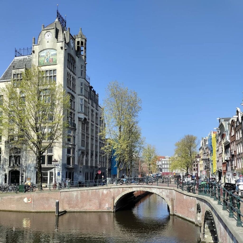
The Astoria: An Unwanted Neighbour That Became a Landmark
Of all the buildings that frame Bridge 52, none is more extraordinary, or more historically contentious, than the structure that stands immediately at the Keizersgracht corner of the Leliegracht on the eastern bank: the building known today as the Astoria.
Astoria is a Jugendstil office building at Keizersgracht 174-176 in Amsterdam, built in 1904-1905 as the headquarters of the Eerste Hollandsche Levensverzekerings Bank insurance company. The building, at the intersection of the Keizersgracht and Leliegracht canals, served as the international headquarters of Greenpeace for 15 years. In 2001, it gained rijksmonument (national monument) status.
With six floors and a maximum height of 37 metres, the Astoria building was one of the first office towers in the Netherlands. The building was a design by H.H. Baanders and Gerrit van Arkel, two architects who designed many buildings in Amsterdam in a sober version of Jugendstil which later came to be known as Nieuwe Kunst (“New Art”). The Astoria building has a copper-plated roof with a small tower and decorative cast-iron fencing with EHLB (for Eerste Hollandsche Levensverzekerings Bank) in gold lettering.
The building’s mosaic panel, visible from the canal, depicts a guardian angel flanked by two allegorical figures representing the protective mission of a life insurance company, a piece of iconographic advertising that has survived a century of changing occupants. The building’s structural system was also genuinely innovative: its skeleton of reinforced concrete was supplied by Bureau Technique Central in Paris, using the patented Hennebique system, making it one of the earliest applications of this technology to a tall building in the Netherlands.
What the Stadsarchief Amsterdam’s own building description makes clear is that the Astoria was not immediately admired. As late as 1963, a guidebook to Amsterdam described the building as an “architectonisch misbaksel” (an architectural misfire) that damaged the beautiful canal view at the Keizersgracht-Leliegracht-Westertoren axis. This is a useful reminder that the bridge and the buildings around it were not always experienced as a harmonious ensemble. Gerrit van Arkel, one of the Astoria’s architects, faced sustained criticism from his colleagues for participating in what was seen as an act of scale-breaking vandalism against the canal streetscape. He was, it seems, ahead of his time. The Astoria is now a rijksmonument (protected national monument, registration number 518354), and it is regularly cited as a pioneering example of the Dutch Art Nouveau office tower.
Bridge 52 sits in the permanent foreground of the Astoria’s Keizersgracht facade, a fact documented explicitly in a Stadsarchief Amsterdam archive photograph whose caption reads “Op de voorgrond brug 52” (“In the foreground, Bridge 52”). In no other single image is the bridge’s relationship to its built environment stated more plainly.
Architectural Character: A Bridge With a Modified Identity
Bridge 52 is a fixed vault bridge (vaste wulfbrug) in its current outward form, meaning it presents as a single-arch masonry crossing over the Leliegracht at the Keizersgracht mouth. Its structural span is reinforced concrete, installed during the 1979 to 1982 reconstruction, clad in the pre-numbered original stones that were removed from the previous bridge and carefully replaced.
As noted above, the arch form of the current bridge is historically novel for this location. The three-passage flat girder bridge that Jacob Olie photographed in 1896, and that the 1904 postcard still confirmed, was a very different structure. The decision to give the 1980s reconstruction an arched profile was a design choice by the Dienst der Publieke Werken, informed by the broader restoration philosophy applied to the canal ring in the late 20th century, which prioritised the visual harmony of the street ensemble over strict archaeological fidelity to the most recent pre-reconstruction form.
The bridge carries wrought iron railings in a standard municipal pattern, granite nose-protection stones at the canal-facing corners of its abutments, and, on its parapet, the two embedded date stones that tell its true story. There is no bridge-keeper’s house (brugwachtershuisje) at Bridge 52. The crossing is a fixed bridge requiring no operational staff, and since 2012 all remaining movable bridges in Amsterdam’s centre have been controlled remotely from a central room, a change that rendered even the nearby bridge-keeper posts obsolete.
Bridge 52 has no confirmed attribution to a named architect in the archival record for either its 1892 or its 1980s reconstruction. The 1892 lowering and the subsequent 1980s restoration were both products of the Dienst der Publieke Werken’s engineering and architectural departments working in institutional rather than individual modes. The Piet Kramer era, which did attach individual authorship to specific bridge designs, ran from approximately 1917 to 1952 and produced the expressionist Amsterdam School bridges of the southern and western canal belt. Bridge 52, in its various historical forms, predates and postdates that period without falling within its direct stylistic influence.
Urban Context: Where the Jordaan Meets the Canal Belt
To stand on Bridge 52 and look westward along the Leliegracht is to look into the Jordaan as it was most purely imagined: a tight, intimate residential canal lined with 17th- and 18th-century canal houses, their gabled facades reflected in a water surface that catches the sky and the elm branches in equal measure. The Leliegracht is one of the few Jordaan transverse canals to have survived the 19th-century infilling campaigns that eliminated six of the eleven original Jordaan waterways. Its survival was partly a matter of hydraulic function (the water level gradient managed by the Leliesluis made it a necessary channel), and partly a matter of the canal’s role as a route connector between the two great parallel arteries of the Keizersgracht and the Prinsengracht.
To the east, across the Keizersgracht, is the Westermarkt and the Westerkerk, its 85-metre Westertoren directly visible from the bridge. The sight line along the Keizersgracht from Bridge 52 is one of the canal ring’s defining photographic corridors: a long, straight perspective view flanked by double rows of elm trees and gabled facades, terminating in the church tower’s blue Imperial crown.
Directly on the Keizersgracht corner beside the bridge stands the Astoria building, now a rijksmonument and one of the most architecturally distinctive structures in the immediate neighbourhood. Its Jugendstil stonework and copper roof create an unusual counterpoint to the 17th-century brick facades on either side. The building’s former occupant, Greenpeace, operated its international headquarters here from 1989 to 2004, making this canal corner briefly one of the most internationally prominent addresses in Amsterdam’s modern environmental history.
Looking westward from Bridge 52, the Leliegracht unfolds in the direction of the Prinsengracht and the Leliesluis (Bridge 61). The ghost of the original Leliesluis hydraulic lock is still partly visible in the Leliegracht at its Prinsengracht end, the remains of the chamber walls and lock contours preserved in the canal bed.
The Bridge Today: A Fixed Stage for Two Neighbourhoods
Bridge 52 today functions as a pedestrian and bicycle crossing, part of the dense local cycling network that connects the Jordaan with the broader canal belt. It carries no motorised traffic of significance and sits within a zone where cyclist priority is effectively unchallenged. The bridge’s deck is granite-paved in the standard Amsterdam municipal style of the post-1980 canal ring restoration era, and its dimensions are modest: sufficient for cyclists to pass in both directions with a narrow margin, but not a promenade.
The bridge’s photographic appeal is not in itself, precisely, but in what it frames. Standing at its centre and looking east along the Keizersgracht, one has access to the same view that has drawn photographers, painters, and tourists to this corner since at least the 18th century: the broad canal, the tree canopy, and the Westertoren. Looking west, the Leliegracht offers a quieter, more intimate prospect, one of old Amsterdam in its most residential register, interrupted at its near end by the copper crown and Jugendstil stonework of the Astoria building rising improbably above the roofline.
There are no commemorative plaques on Bridge 52. There are no zinloos geweld memorials. The only inscriptions are the civic ones: the number 52 on the east face of the parapet, and the year 1982 on the west face.
Technical Specifications Summary
Bridge type: Fixed vault bridge (vaste wulfbrug). The exterior presents as a single-arch masonry crossing; the structural span is reinforced concrete, installed during the 1979 to 1982 reconstruction. Note: the arch form is a new design, not a restoration of the previous bridge’s three-passage flat girder form.
Materials: Natural stone cladding (pre-numbered original stones, reset in 1982) over a reinforced concrete structural core. Wrought iron railings in municipal standard pattern. Granite nose-protection stones at the canal-facing abutment corners.
Location: Keizersgracht, western quay, at the mouth of the Leliegracht. Municipal coordinates approximately 52°22’31″N, 4°53’08″E (per Wikidata and Stadsarchief reference).
Catalogue number: 52, per the Index of Bridges in Amsterdam maintained by the Dienst der Publieke Werken.
Key dates: Earliest cartographic evidence of a bridge at this location, circa 1618 (plot division map, five arches). Balthasar Florisz. van Berckenrode map, 1625 (three passages). Joan Blaeu map, 1649 (single passage). Recorded in three-passage flat girder form by Jacob Olie, 1896. Same form confirmed by postcard, 1904. Joint lowering and widening of bridges 51, 52, and 53, 1892. Full restoration reconstruction, 1979 to 1982.
Designers: The 1892 lowering and the 1980s restoration were both products of the Dienst der Publieke Werken, without confirmed individual architect attribution.
No bridge-keeper’s house. Fixed bridge, remote operation from central control room since 2012.
Adjacent rijksmonument: The Astoria building, Keizersgracht 174-176, rijksmonument registration number 518354, designed by H.H. Baanders and Gerrit van Arkel, built 1904-1905, is the dominant landmark in the immediate streetscape of Bridge 52.
A Note on Difference
The previous post in this series examined Bridge 51 and centred its story on the 1864 reconstruction tender and the civic debate about filling in the Keizersgracht. Bridge 52 tells a different story, not of structural failure and emergency rebuilding, but of a crossing that was quietly and efficiently modernised in 1892 into something visually quite unlike what came before or after, and then, in the 1980s, given an entirely new historic identity. The Jacob Olie photograph is the most honest document we have for what Bridge 52 really looked like in its working life: not a graceful arch, but a flat, multi-passage, iron-girder bridge doing its utilitarian job in a city that had stopped romanticising its infrastructure and had not yet started re-historicising it.
The 1982 arch is, in that sense, a post-modern creation: a bridge designed to look old in a way it never actually was. It is also, viewed charitably, one of the most successful pieces of urban scenery-making in the canal ring, a structure that sustains the visual integrity of a UNESCO World Heritage streetscape by telling a small, beautiful, and entirely transparent lie.
Brug 52 map and location
Bridge 52 is located in the western quay of the Keizersgracht and spans the Leliegracht. Seen from the centre just behind this bridge is the Leliesluis. It is flanked by #bridge51 (adjoining) and #bridge53 (on the opposite side of Keizersgracht), spanning the Keizersgracht and the Leliegracht.
There has been a bridge here for centuries. On the map of Balthasar Florisz. van Berckenrode from 1625 is a bridge with three passages drawn over the Lely Graft in the Keysers Graft with the Lely Sluys behind it. However, the map with the plot division south of the Leliegracht between Keizersgracht and Prinsengracht from around 1618 also showed a bridge (five arches). Joan Blaeu , however, drew a bridge with one passage on his 1649 map.


Bridge 52 information and history
The modern history of #bridge52 is obviously very similar to #bridge51.
Although in the 21st century, there is a bridge with a passage, Jacob Olie recorded a bridge with three passages and without arches in 1896 and a postcard from 1904 showed the same image. The 1979 bridge shows bridge number 52 on the side of the Keizersgracht in the upper archstone.
In 1892 a new tender took place and the three bridges (51, 52 and 53) had to be lowered. It was not until almost a century later that there was work to be done again from 1979 to mid-1982 the bridge complex was under construction, with bridge 51 being completed last (around August 1982). The stones were pre-numbered to make the work go smoothly. Bridge numbers 52 (east side) and 1982 (west side) can be read on two stones. All this to give the bridge an “antique” appearance, while the bridge was given a concrete span although an architectural lie.


Bridge 52
Photos from the archive
1 Bridge 52 Oord-de Pee, Annemieke van, 1990 ca.
2 Bridge 52 en het Bank, CuneHetteman, Collectie Bureau Monumentenzorg 1984
3 Bridge being rebuilt Spoelstra, Y. Collectie Bureau Monumentenzorg 1980
Sources and Archival References
- Cramberts / Bridges of Amsterdam (bridges.cramberts.com): “Brug tweeenvijftig, Bridge 52: History and Information,” April 2022 (updated October 2023). Primary source for the Jacob Olie 1896 photograph record, the 1904 postcard confirmation, the 1892 lowering, and the 1979 to 1982 reconstruction with pre-numbered stone account and “architectural lie” context. https://bridges.cramberts.com/amsterdam/history/brug-tweeenvijftig-bridge-52-history-and-information/
- Cramberts / Bridges of Amsterdam (bridges.cramberts.com): “Brug tweeenvijftig, Bridge 52: Amsterdam,” April 2022. Supplementary account confirming date stones (east side “52,” west side “1982”) and the three bridges being “fake antique.” https://bridges.cramberts.com/amsterdam/bridges/brug-tweeenvijftig-bridge-52-amsterdam/
- Cramberts / Bridges of Amsterdam (bridges.cramberts.com): “Brug tweeenvijftig, Bridge 52: Map and Location,” April 2022. Source for the western quay position, the Leliesluis relationship, and the van Berckenrode 1625 / Blaeu 1649 cartographic evidence. https://bridges.cramberts.com/amsterdam/map/brug-tweeenvijftig-bridge-52-map-and-location/
- Wikipedia, “Astoria (Amsterdam)”: Building history, architects, dimensions, Greenpeace occupation, and rijksmonument status (2001). https://en.wikipedia.org/wiki/Astoria_(Amsterdam)
- Rijksmonumenten.nl, Monument 518354: Official rijksmonument designation record for the Astoria building (Gebouw Astoria), Keizersgracht 174-176, including full architectural description of the Nieuwe Kunst design, the Hennebique reinforced concrete system, and the 1966 extension. https://rijksmonumenten.nl/monument/518354/gebouw-astoria/amsterdam/
- Wikipedia, “Herman Hendrik Baanders”: Biographical data on co-designer of the Astoria, including death during the building’s construction in 1905. https://en.wikipedia.org/wiki/Herman_Hendrik_Baanders
- Amsterdam Monumentenstad database (amsterdam-monumentenstad.nl): Full archival building record for Astoria/Keizersgracht 174-176, including the 1963 critical guidebook assessment (“architectonisch misbaksel”) and the Wegener Sleeswijk 1969 extension. https://www.amsterdam-monumentenstad.nl/database/grachtenboek_objecten.php?id=2325
- Stadsarchief Amsterdam Beeldbank: Photographic archive holding the “Op de voorgrond brug 52” Astoria image (accession 4544839f-9377-1669-6080-035069a6b4ba), and the Y. Spoelstra 1980 reconstruction photographs (Collectie Bureau Monumentenzorg). https://archief.amsterdam/beeldbank/
- Ons Amsterdam (onsamsterdam.nl): “Leliesluis, 14 mei 1659: Instortende brug.” Primary historical account of the 1659 Prinsengracht bridge collapse at the Leliesluis junction, with citation from Isaac Commelin’s Beschrijvinge van Amsterdam (1691). Confirms the hydraulic and structural history of the entire Leliegracht corridor. https://onsamsterdam.nl/artikelen/leliesluis-14-mei-1659-instortende-brug
- Wikipedia, “Leliesluis” (Dutch): Account of Bridge 61 (the Leliesluis), its hydraulic history from around 1614, and its relationship to the Leliegracht water level management system. https://nl.wikipedia.org/wiki/Leliesluis
- Grokipedia, “Leliegracht”: Detailed account of the Leliesluis lock function, canal construction dating, and the survival of the Leliegracht through the 19th-century infilling campaigns. https://grokipedia.com/page/leliegracht
- Wikipedia, “Leliegracht”: Etymology, post-1612 construction date, lock history, and neighbourhood context. https://en.wikipedia.org/wiki/Leliegracht
- Wikipedia, “Jacob Olie”: Biographical data on the Amsterdam photographer (1834-1905) whose 1896 glass-plate photograph of Bridge 52 provides the definitive visual evidence of the bridge’s three-passage flat girder form before the 1980s reconstruction. https://en.wikipedia.org/wiki/Jacob_Olie
- Wikimedia Commons, Category: Brug 52 (in Amsterdam): Photographic archive including the “Leliegracht tussen Keizersgracht en Prinsengracht.jpg” image and the “Overzicht, Amsterdam, 20018089, RCE.jpg” (RCE/Bureau Monumentenzorg photograph). https://commons.wikimedia.org/wiki/Category:Brug_52_(in_Amsterdam)
- Balthasar Florisz. van Berckenrode, Map of Amsterdam, 1625: Earliest confirmed cartographic evidence of a three-passage bridge over the Lely Graft at the Keysers Graft, with the Lely Sluys noted behind it. Held in multiple Dutch public collections including the Stadsarchief Amsterdam.
- Stadsarchief Amsterdam (Amsterdam City Archives): Primary municipal archive for all construction records, tender specifications, and photographic collections referenced above. https://www.amsterdam.nl/stadsarchief/