
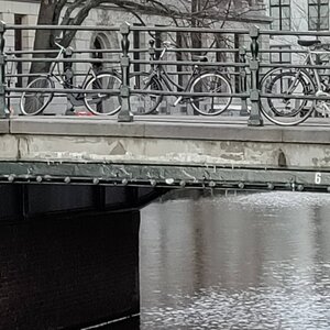
Bridge Number 6 (Brug 6): The Bridge Without a Name
Bridge number 6 (Brug Zes) is an unnamed bridge spanning Singel. Until 5 July 2016, this bridge was unofficially known as Gasthuisbrug, named after the Gasthuismolensteeg. Since then, this name has been dropped and it remains officially without a name although is a municipal monument. Some great views from this bridge of Het Bungehuis (now Soho House Amsterdam). The bridge connects Paleisstraat with Gasthuismolensteeg.
The Bridge That Lost Its Name
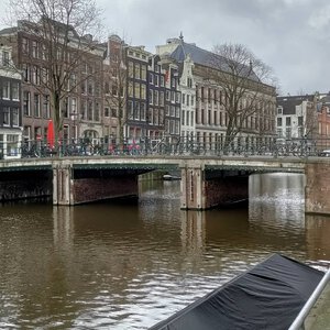
There is a peculiar kind of obscurity that comes not from being forgotten but from being deliberately unnamed. Bridge 6 over the Singel, connecting the Paleisstraat on the canal’s east bank to the Gasthuismolensteeg on the west, is that kind of bridge. It has been crossed by Dutch royalty on their way to coronations, painted in oils by one of the Netherlands’ greatest Impressionist artists, and documented on Amsterdam’s city maps since at least 1649. It is a designated municipal monument. And since 5 July 2016, it has had no official name.
This is not neglect. It is policy. In 2016, the Amsterdam municipality made a formal decision to withdraw all unofficial bridge names across the city. Bridges 8, 13, and numerous others lost their locally acquired nicknames in the same sweep. Bridge 6 had been known informally as the “Gasthuismolenbrug,” a name derived from the street it serves on its western side, which in turn preserved the memory of a mill that stood at the end of the Paleisstraat in the sixteenth century, before the street had acquired its current, more regal name. Since 2016, the bridge has gone through life, in the words of the municipal record, simply by its number.
What that number means, and what that number conceals, is the subject of this update.
A Note on Naming: Why Some Bridges Have Names and Others Do Not
Amsterdam has more than 1,200 bridges, of which roughly 998 carry official names. The rest are identified by number alone. The distinction between named and numbered bridges is not a measure of historical significance: Bridge 6, with its centuries of documentary evidence and its protected monument status, is considerably more historically legible than many bridges that carry grand official titles.
The decision to assign official names to specific bridges is a municipal one, typically made by the city council (gemeenteraad). In recent years, Amsterdam has shown a willingness to name bridges for reasons of civic commemoration rather than geographical convenience: Bridge 5, the immediate neighbour of Bridge 6 to the south, was renamed the Joes Kloppenburgbrug in 2017 following a council decision in 2016, explicitly as a memorial to a victim of street violence. The naming was both a local tribute and a national statement.
Bridge 6 has received no equivalent petition or council decision in the years since 2016. It remains, at the time of writing, one of the more historically substantial unnamed bridges in the city centre. Whether a future naming ceremony will eventually attach a person or a place to its parapet is, for now, an open question. What is clear is that its anonymity is the product of a specific administrative moment, not of any absence of story.
The Oldest Layers: Joan Blaeu, a Drawbridge, and the Hospital Mill
The story of this crossing begins, as so many Amsterdam bridge histories do, in the age of the great city maps. Bridge 6 appears on Joan Blaeu’s celebrated map of Amsterdam from around 1649, one of the most detailed cartographic records of the seventeenth-century city. On the even earlier map of Balthasar Florisz. van Berckenrode, the crossing is shown as a drawbridge (ophaalbrug), the standard form for a canal crossing in an era when water traffic was still the dominant form of commercial movement through the city and the ability to raise a bridge for tall-masted vessels was a functional necessity.
The Gasthuismolensteeg, on the west bank where the bridge lands, takes its name from a mill (molen) that occupied the corner of what is now the Paleisstraat at the Singel’s edge. This mill was associated with the Sint-Elizabethsgasthuis, a medieval charitable hospital, or gasthuis, that served the surrounding neighbourhood. The gasthuis gave its name to the alley, and the alley gave what would eventually become the bridge’s informal designation. The mill itself was demolished by the end of the sixteenth century, but it survived long enough in local memory to be fixed into a street name that persists to this day.
The street on the east bank of the Singel has a similarly layered history. What is now called the Paleisstraat, running directly along the south flank of the Royal Palace and connecting Dam Square to the Singel, was known until 1875 as the Gasthuissteeg, “the hospital alley,” also referencing the Sint-Elizabethsgasthuis. The renaming to Paleisstraat came only after the palace had sufficiently reshaped the district’s identity that the old hospital name seemed incongruous. For Bridge 6, this means that both streets it connects preserve, in different ways and under different degrees of transformation, the memory of the same medieval institution.
The Stone Arch of 1711 and the Great Flattening of 1876
By the early eighteenth century, the crossing at this location had been rebuilt as a stone arch bridge, a permanent and more substantial structure than the wooden drawbridge of the seventeenth century. This stone arch, in place from 1711, gave the bridge the characteristic high-humped profile, what Amsterdammers called the bolle brug or convex bridge, that characterised the Singel’s crossings in the period before the demands of modern traffic reshaped them.
The bolle brug of 1711 endured for more than a century and a half. It appears in Breitner’s preparatory sketches and in the visual memory of the canal before the decisive intervention of 1876, when the city replaced the arched stone bridge with a flat fixed crossing. The reason was practical and familiar from the history of Amsterdam’s other Singel bridges: the steep profile of the convex arch had become incompatible with the heavier commercial loads and, increasingly, with the requirements of an expanding urban transport network. Horse-drawn carts and delivery vehicles could negotiate the arch only with difficulty; the slope was too steep for normal traffic. The 1876 replacement brought the bridge’s profile down to the low, level form it has retained ever since.
The Singel bridges were not the only structures affected by this trend. Across the city, the period from roughly 1860 to 1900 saw a systematic flattening of the older arched crossings, driven by the same combination of increased axle loads and the arrival of tram infrastructure that required smooth, level surfaces. Bridge 6’s transition in 1876 is a local chapter in a citywide transformation.
Breitner’s Bridge: The Rijksmuseum Painting
Here is the detail that most visitors to Bridge 6 do not know, and which elevates this modest, number-only crossing into an unlikely chapter of Dutch art history.
Between 1896 and 1898, George Hendrik Breitner (1857-1923), Amsterdam’s preeminent Impressionist painter and one of the defining artistic voices of the city in the late nineteenth century, painted a large oil on canvas depicting the Singel bridge at the Paleisstraat in the rain. The work, measuring 100 by 152 centimetres, is now in the permanent collection of the Rijksmuseum under the catalogue number SK-A-3580, and is considered one of the most significant paintings in Breitner’s body of work. It shows a figure crossing the bridge in characteristic “Breitner weather”: grey, damp, and atmospheric, with the arch and parapet of the bridge visible and the surrounding canal scene dissolving into the mist.
Breitner was an early adopter of photography as a preparatory tool. Using a Kodak No. 1 Box camera with preloaded film, he documented Amsterdam’s streets and canals in the 1890s with an eye for the transient and the atmospheric, and it is thought that he photographed this bridge and its surroundings as part of his working method for the Paleisstraat canvas. Several photographic studies for the work are known. The painting passed through revisions: Breitner initially depicted the central figure as a housemaid, but altered her into a more elegantly dressed woman following critical feedback from his gallery.
The Breitner connection is significant for several reasons. First, it places Bridge 6 in the permanent collection of the Netherlands’ most visited museum, visited by more than a million people a year. Second, it documents the bridge in its post-1876 flat form, showing what the structure looked like in the late 1890s, approximately two decades after the replacement of the stone arch. Third, it connects the bridge to Amsterdam’s wet-cobblestone aesthetic: when the streets are grey and drizzling in the city, residents still use the phrase “Echt Breitnerweer” (real Breitner weather) to describe the conditions he captured in this painting and dozens of others.
Bridge 6 is, in this sense, already in a museum. It just has not been told.
The Coronation Route and Monument Status
The bridge’s connection to Dutch royal history is documented in another, more practical register. The Gasthuismolensteeg, on the west bank, was historically one of the busiest streets in Amsterdam: it was among the first to be designated one-way for traffic in the seventeenth century, a measure that reflects both the intensity of movement through this corridor and the difficulty of managing it in a pre-traffic-signal era. This made Bridge 6 part of the standard routes used by Dutch royalty and civic dignitaries on formal journeys through the city centre.
The coronation of Queen Wilhelmina in 1898 is specifically documented as a moment when the bridge was maintained and widened to accommodate the processional requirements of the occasion. Wilhelmina was crowned on 6 September 1898 in Amsterdam, and her route through the city centre required the bridges along the Singel to be in reliable condition and of sufficient width for a royal procession. Bridge 6’s position on the Paleisstraat corridor, running from the Singel directly to the south side of what had been the city hall and was now the Royal Palace, made it a natural element of this processional geography.
In 1995, the bridge was formally designated a gemeentelijk monument: a municipal monument, protected under Amsterdam’s heritage regulations. The designation reflects both the age of the structure and its historical associations. It is a fixed girder bridge, its deck composed in the materials characteristic of its period: brick with granite trim, the combination that gives the Singel’s bridges their particular quality of permanence. The abutments, built into the canal banks on both sides, incorporate the kind of functional recesses typical of the era’s bridge construction, providing housing for electrical infrastructure and utility connections within the body of the bridge itself.
Piet Kramer and the Public Works Aesthetic
The question of whether Piet Kramer had a hand in Bridge 6’s current appearance is one that the available public records do not resolve with certainty. What can be said is that Kramer, who worked within Amsterdam’s Gemeentelijke Dienst Publieke Werken (the municipal Public Works Department) from around 1910 onward and who produced drawings for more than 500 bridges, was the dominant influence on the aesthetic of the Singel crossings during the first decades of the twentieth century. Even bridges that he did not design from scratch were often maintained, adapted, or given their decorative ironwork by the department he shaped.
The characteristics associated with Kramer’s bridge work are worth describing, because they are the features to look for when crossing Bridge 6 on foot. His bridges are identified by their wrought-iron railings, which tend toward organic, expressionist forms rather than the geometric repetition of earlier Victorian ironwork. His lamp standards, where they survive, are tall and architecturally considered, their proportions carefully scaled to the width of the bridge deck. His use of brick is characteristically warm, textured, and handsome in a way that the more industrially produced stonework of the previous century rarely achieved.
The bridge at Paleisstraat, rebuilt in 1876 and a designated monument since 1995, sits within the zone where Kramer’s influence on the Public Works Department would have been felt most directly. Whether the current railings, lamp standards, or bridge abutment detailing reflect a Kramer-period intervention, a later update, or the original 1876 construction in a preserved form is a question that would require access to the Stadsarchief Amsterdam’s Public Works technical drawings to answer definitively. Researchers interested in this question should consult the Stadsarchief’s records under the Gemeentewerken classification, where the design history of the individual Singel bridges is held.
The Gateway to the Nine Streets: Hidden in Plain Sight
The west bank of Bridge 6 opens directly into the Gasthuismolensteeg, the northernmost of the three cross-streets that form the upper row of the Negen Straatjes grid. The Nine Streets (De Negen Straatjes) is one of the most-photographed and most-visited shopping districts in the world: nine narrow alleys connecting four of Amsterdam’s major canals (Singel, Herengracht, Keizersgracht, and Prinsengracht), lined with independent boutiques, galleries, vintage shops, and the kind of idiosyncratic urban retail that larger shopping districts tend to eliminate. The area has been promoting itself under this name since the 1990s, though the streets themselves date to the early seventeenth century, when Amsterdam’s third great city expansion laid out the canal belt.
More than 140 national and municipal monuments are located within the boundaries of the Negen Straatjes. The district is part of the UNESCO World Heritage-listed grachtengordel. On any given afternoon, it draws visitors from across Europe and beyond, many of them arriving from the Singel side and crossing Bridge 6 without noticing what they are crossing.
This “hidden in plain sight” quality is the bridge’s particular character. It is the northern gateway to one of Amsterdam’s most-visited destinations, and it carries that function invisibly, without announcement or ceremony. The person photographing the Gasthuismolensteeg from the bridge’s western parapet is, whether they know it or not, standing in roughly the position from which Breitner’s camera documented the same canal view a hundred and thirty years ago.
The View: South Toward De Krijtberg
Standing on Bridge 6 and looking south along the Singel, the skyline produces one of the more rewarding views available from any of the canal’s central crossings. The twin towers of De Krijtberg, the Jesuit church at Singel 446 designed by Alfred Tepe and consecrated in 1883, rise at the end of the canal perspective in a way that the flat urban fabric of the Singel’s flanking buildings does not obscure. The towers are Neo-Gothic, narrow and pointed, and they punctuate the view southward with a vertical emphasis that contrasts with the horizontal rhythm of the canal housefronts on either side.
This view, and the corresponding view northward toward the Dam and the roofline of the Royal Palace, gives Bridge 6 a positional significance that its size and current anonymity might not suggest. It is a bridge at the hinge between two distinct urban identities: to the north, the monumental civic Amsterdam of the Dam, the Beurs, and the Koninklijk Paleis; to the south, the domestic, commercial, and intimate Amsterdam of the canal belt and the Nine Streets. The Singel is the seam between these two worlds, and Bridge 6 sits at one of its most legible junctions.
The East Bank: Walking the Palace’s Shadow
Stepping off Bridge 6 to the east, the visitor enters the Paleisstraat, and within a few steps the south facade of the Koninklijk Paleis op de Dam becomes visible above and to the right. The Royal Palace is one of the largest civic buildings of its period in Europe: begun in 1648 as Amsterdam’s city hall, designed by Jacob van Campen on 13,659 wooden foundation piles, and converted to royal use in 1808 when Napoleon’s brother Louis Bonaparte took it as his Amsterdam residence. It has been a working palace, a museum, and, since the mid-twentieth century, the official reception palace of the Dutch monarchy.
The Paleisstraat was known until 1875 as the Gasthuissteeg, the “hospital alley,” in reference to the same Sint-Elizabethsgasthuis whose memory is preserved in the Gasthuismolensteeg on the opposite side of Bridge 6. The renaming of the street to Paleisstraat acknowledged the reality that the palace had, over more than two centuries, entirely reshaped the identity of the block. The old name was retired, as the old name of the bridge would be retired more than a century later, by an act of municipal administration.
What this means in practice is that Bridge 6 connects a street named for the palace it leads toward (east) with a street that still carries the name of a medieval hospital it no longer leads toward (west). It is, in this small way, a bridge between Amsterdam’s civic self-image and its working past: the grand and the workaday occupying their respective banks of the same canal, connected by a numbered crossing with no official name.
Research compiled February 2026. Primary sources include: Amsterdam city archive records at the Stadsarchief Amsterdam (stadsarchief.amsterdam.nl); Bridges of Amsterdam archival reference (bridges.cramberts.com/2022/02/19/brug-zes-bridge-6); the Amsterdam historical map resource amsterdamopdekaart.nl (1850-1940, Gasthuismolensteeg/Brug 6 record); the Rijksmuseum collection record for George Hendrik Breitner, “The Singel Bridge at the Paleisstraat in Amsterdam,” 1896-1898 (SK-A-3580, rijksmuseum.nl); Wikipedia article on the Negen Straatjes; Wikipedia article on the Royal Palace of Amsterdam; and Wikimedia Commons records on Paleisstraat, Amsterdam. For full architectural and engineering specifications, consult the Stadsarchief Amsterdam’s Gemeentewerken technical drawings under the Singel bridge classifications.
Key Facts at a Glance
Official name: None (unnamed since 2016) Bridge number: 6 (Brug 6) Former unofficial name: Gasthuismolenbrug (or Gasthuisbrug), withdrawn 5 July 2016 by municipal policy decision applying to all unofficial bridge names city-wide Location: Singel, connecting Paleisstraat (east bank) to Gasthuismolensteeg (west bank) Type: Fixed girder bridge (vaste brug) Materials: Brick with granite trim; utility infrastructure integrated into bridge abutments Earliest documentation: Joan Blaeu’s map of Amsterdam, ca. 1649 (shown as a drawbridge on van Berckenrode’s earlier map) 1711: Stone arch (bolle brug) bridge constructed, replacing earlier wooden crossing 1876: Stone arch replaced by current flat fixed bridge; steep profile deemed incompatible with modern traffic 1898: Bridge maintained and widened for Queen Wilhelmina’s coronation route through the city 1896-1898: George Hendrik Breitner paints “The Singel Bridge at the Paleisstraat in Amsterdam” (now Rijksmuseum SK-A-3580, 100 x 152 cm) 1995: Designated a gemeentelijk monument (municipal heritage monument) 2016: Unofficial name withdrawn; bridge reverts to number-only designation Naming status (2026): No pending proposals identified; bridge remains unnamed Nearby landmarks: Koninklijk Paleis op de Dam (Royal Palace, Jacob van Campen, 1648, approximately 200 metres east); De Krijtberg church (Alfred Tepe, 1883, visible to the south along the Singel) Urban context: Northern gateway to De Negen Straatjes (Nine Streets); the Gasthuismolensteeg (west bank) is the northernmost of the Nine Streets grid Street name history: Paleisstraat (east bank) was known as Gasthuissteeg until 1875; both names derive from the Sint-Elizabethsgasthuis, a medieval charitable hospital View southward: Twin towers of De Krijtberg visible along the Singel perspective Breitner connection: The same bridge depicted in a major Rijksmuseum oil painting; Breitner’s phrase “Echt Breitnerweer” (“real Breitner weather”) still used by Amsterdammers to describe grey, rainy days

There has been a bridge at the location of Bridge 6 for centuries. The bridge is already drawn on Joan Blaeu ‘s map from circa 1649, but this bridge has also been drawn as a pick-up bridge on Balthasar Florisz’s map. van Berckenrode from 1625, then between the Mole Steech (The Palace on Dam Square was not completed as a town hall until 1665) and Mole Street. Later a permanent fixed bridge was built here in 1876; the slopes were too steep for normal traffic (think of horse and carriage and steep hills!). George Hendrik Breitner painted the bridge as a vault bridge.
Although the Gasthuismolensteeg was one of the busiest streets in Amsterdam (it was one of the first streets to have one-way traffic in the 17th century), until the opening of the Raadhuisstraat, relatively little is known about this bridge. It was regularly maintained and widened, because it was part of the (almost) fixed routes that kings and queens used on their journeys through the city, including the coronation of Wilhelmina of the Netherlands in 1898. In 1995 the bridge was named a municipal monument.
The bridge was given the unofficial name Gasthuismolenbrug, a name after the street, which is in turn named after a mill, which was demolished sometime at the end of the 16th century. The mill stood where the current Paleisstraat crosses the Singel. Gasthuis refers to the Sint-Elizabethsgasthuis, which also stood here. In 2016, the municipality withdrew all unofficial names and the bridge has since through life anonymously (referred to only by a number). One of the reasons for this is that bridge 218 was also nicknamed Gasthuisbrug, a reference to the Binnengasthuis, which could be confusing and then to make things a little more complicated Utrecht has an official Gasthuismolenbrug.
Architect: Unknown
Brug 6 is a fixed bridge in Amsterdam Centrum. It is a road bridge connecting Paleisstraat with Gasthuismolensteeg. Bridge 6 spans the Singel near to the Bungehuis (Soho House) which is located southeast of the bridge.
This bridge is a stones throw from the Royal Palace at Dam Square.

https://w3w.co/teaspoons.resist.score
https://w3w.co/heet.inloggen.filmhit
///teaspoons.resist.score
///heet.inloggen.filmhit
52.372211, 4.888396
This what3words address refers to a 3 metre square location. Tap the link or enter the 3 words into the free what3words app to find it.