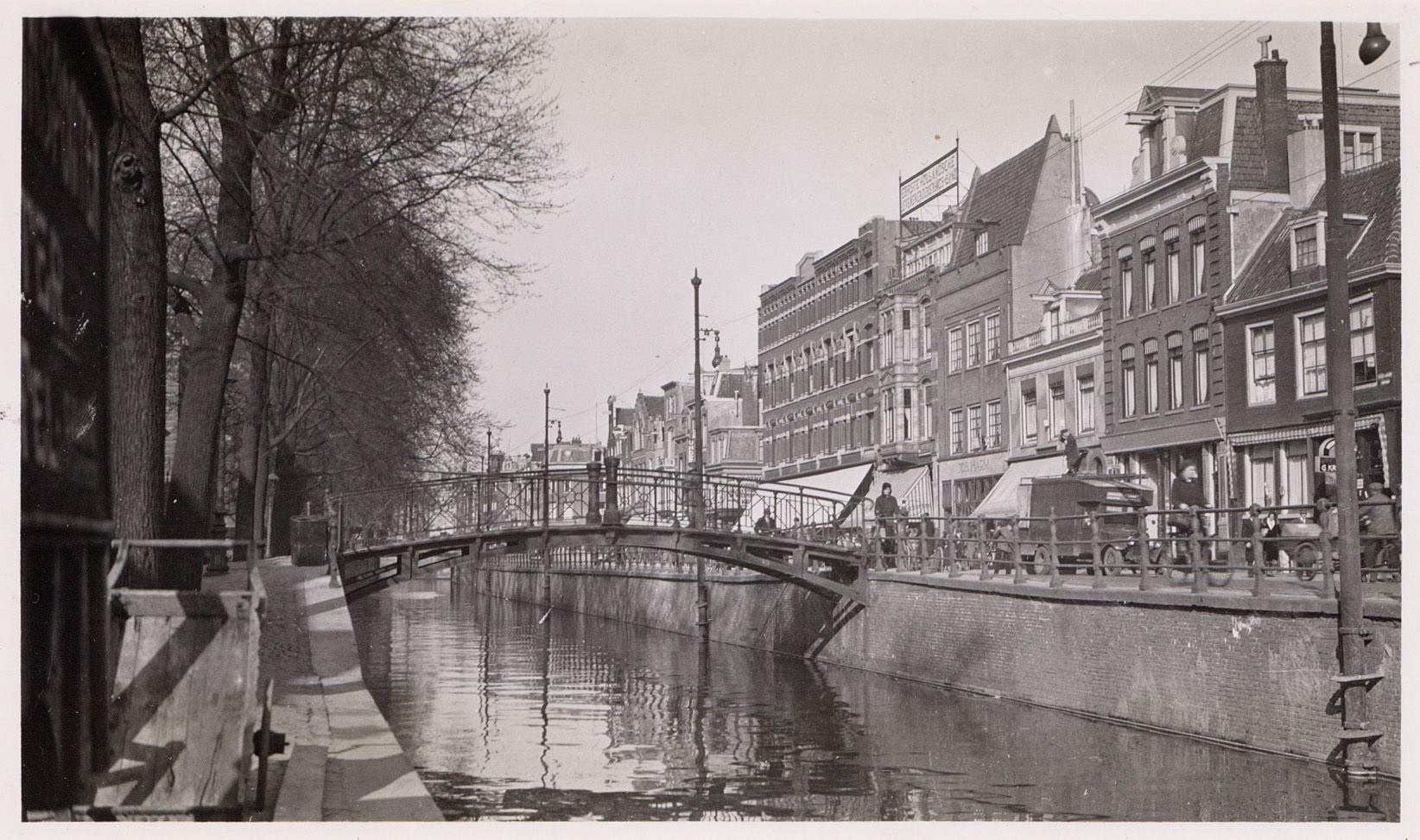
The Bridge That Was Filled In: Brug 83 and the Death of the Vijzelgracht
There is no photograph you can take of Brug 83. There is no map you can put a pin in. The bridge was built in 1882, stood for around fifty years, and then the canal underneath it was filled in and the bridge was taken away with it.
It is the first true vacancy in this series. Bridge 33 is sometimes counted alongside it, but that bridge was built and stood at Sloterdijk until 1956; its number went to Rijkswaterstaat with the site and became 172P. Brug 83 is a number that was used, and then emptied.
What Was There
Brug 83 stood in the southern embankment of the Prinsengracht, carrying it over the Vijzelgracht. It was put in during 1882, and the reason given is unusually specific: it was built for the Walenweeshuis, the Walloon orphanage on the corner, which from 1971 to 2016 housed the French cultural institute Maison Descartes and the French consulate.
A bridge built for a single institution is rare in Amsterdam. Most crossings serve a street. This one served a door.
Its immediate neighbour survives and is covered here: Brug 70, the Walenweeshuissluis, named after the same orphanage.
The Vijzelgracht and Why It Was Filled
The Vijzelgracht was dug as part of the 1658 expansion, the great fourth enlargement that produced the canal ring as we know it. It ran for two and a half centuries.
In 1933 it was filled in. Amsterdam filled a great many canals in the late nineteenth and early twentieth centuries, and the reasoning was consistent: standing water in a dense city was a public health problem, and a filled canal produced something the city wanted more, which was a wide street for traffic. The Vijzelgracht became the Vijzelgracht, a road.
The bridges went with the water. Brug 83 was demolished. So were the two crossings over the Nieuwe Looiersgracht, and Brug 85, a footbridge at the Derde Weteringdwarsstraat which disappeared around 1934 and whose number was later reassigned to a tram viaduct on the other side of the city.
Two survived, both because they crossed water that was not filled: Brug 70 over the Prinsengracht, and Brug 86 over the Lijnbaansgracht.
Why the Numbers Have Holes
This is the clearest illustration of something that confuses everyone who tries to count Amsterdam’s bridges. The municipal numbering is a register, not a tally. Numbers are issued as structures enter the system, and when a structure leaves, the number is not reissued and the sequence is not closed up.
So the register contains 83, and Amsterdam contains no Brug 83. Anyone reading the highest bridge number as a count of bridges will be wrong by a wide margin, which is one reason how many bridges Amsterdam has is a harder question than it looks.
What Is There Now
The Vijzelgracht today is a broad street with the Walenweeshuis and a run of weavers’ cottages still standing along it. Underneath is a metro station on the Noord/Zuidlijn, opened in 2018, and a car park whose only visible presence is a pair of lift structures.
The metro construction, which ran from 2002 to 2018, was among the most troubled engineering projects in the city’s modern history. Buildings on the Vijzelgracht settled, the historic weavers’ cottages sinking by up to 23 centimetres, and defective concrete was found in the diaphragm walls.
There is a symmetry there we think. The canal was filled to make room for traffic on the surface. Eighty-five years later the city dug the ground open again to move that traffic underground, and nearly pulled the street down doing it.
Amsterdam’s Long Habit of Filling In Canals
The Vijzelgracht was not an isolated case. Between roughly 1850 and 1950 Amsterdam filled in a great many of its waterways, and the city we walk through now is missing canals almost everywhere the streets feel unusually wide.
The arguments were always the same three. Standing water in a dense city carried disease, or was believed to. Canals needed dredging and quay walls needed maintaining, and both cost money. And a filled canal delivered, at a stroke, the one thing a nineteenth-century city wanted and could not otherwise buy: a wide straight street.
The Nieuwezijds Voorburgwal, the Rokin in part, the Elandsgracht, the Lindengracht, the Palmgracht, the Westerstraat, all of them were water. Each filling took its bridges with it, which is why the gaps in Amsterdam’s bridge register are not random. They cluster around canals that stopped existing.
The habit stopped, and then reversed. By the 1970s the city had changed its mind about what it had done, and in one case actually dug a filled waterway back out: the Houtkopersburgwal was re-excavated in 1977 after being buried for a decade. Brug 83 was not so lucky. Its canal stayed a road.
Technical Specifications
- Bridge number: 83
- Name: None recorded
- Status: Demolished, number vacant
- Stood in: Southern embankment of the Prinsengracht
- Spanned: Vijzelgracht
- Built: 1882
- Built for: The Walenweeshuis, later Maison Descartes
- Demolished: 1933, when the Vijzelgracht was filled in
- Surviving neighbours: Brug 70 (Walenweeshuissluis) and Brug 86
- On the site today: Vijzelgracht metro station, opened 2018
Sources Consulted
- Featured image: Brug 83, Bridge 83, Amsterdam by Eck, J. van (Jacobus, 1873-1946), 1933, via Wikimedia Commons, Public domain
- Vijzelgracht, Nederlandstalige Wikipedia
- Walenweeshuis, Nederlandstalige Wikipedia
- Vijzelgracht metrostation, Nederlandstalige Wikipedia
- Noord/Zuidlijn, Nederlandstalige Wikipedia
- Stadsarchief Amsterdam, Beeldbank and Publieke Werken archives
- Frank V. Smit, Bruggen in Amsterdam (2008), Uitgeverij Matrijs