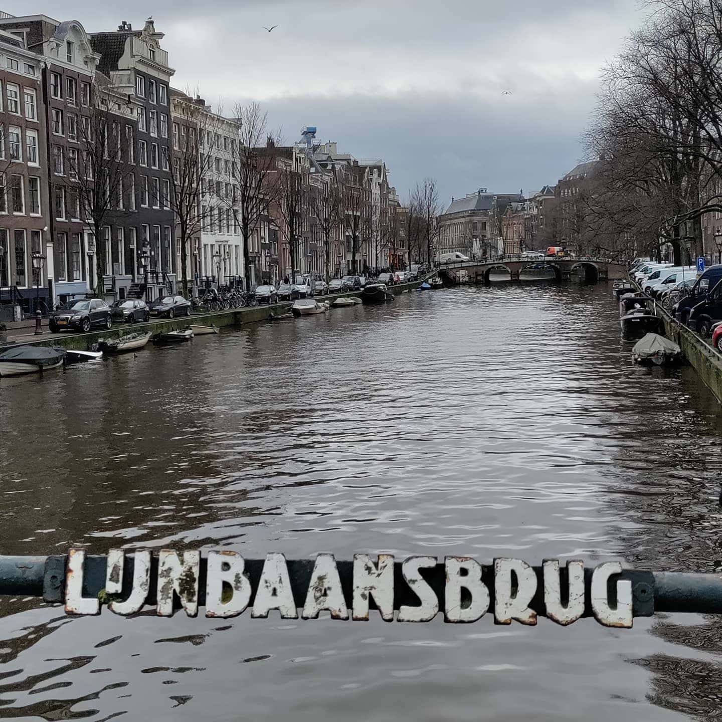
Bridge number 10 (Brug Tien) Lijnbaansbrug or Line track bridge. This bridge connects Lijnbaanssteeg with the southern quay of Blauwburgwal and spans the Singel. Just like the Lijnbaanssteeg, the bridge is named after the line lanes of the rope-makers that were located here when the area outside the Singel (then city boundary) was still a kind of industrial estate. Not to be confused with Lijnbaansgracht, named after the same industry but in a completely different area.
Architects Dienst de Publieke Werken (Public Works Department)
1963: Cornelis Johannes Henke

Bridge 10: The Lijnbaansbrug and the Memory of Rope
Stand on Bridge 10 and look south along the Singel on a clear morning. The water carries the dome of the Round Lutheran Church in reflection, a perfect copper hemisphere floating just below the canal’s surface. Turn north and the Singel opens toward the Brouwersgracht junction, the end of the canal’s long run from Muntplein. Between these two views, beneath your feet, is a bridge named for an industry that once shaped this part of the city entirely: the making of rope.
The Lijnbaansbrug connects the Singel with the Blauwburgwal, the short canal that leads back into the old city’s fabric. Its name is not ceremonial, not a dedication to a patron or civic figure. It records a fact: there was a rope walk here. The lijnbaan is written into the address of the bridge, and understanding what a rope walk was, and why it existed in this particular part of Amsterdam, is the key to understanding why the northern Singel looked the way it did in the seventeenth century.
What a Rope Walk Was, and Why It Mattered
A lijnbaan (rope walk) was a long, straight strip of ground where rope-makers worked. The process of making rope from raw hemp required the strand to be stretched while it was twisted; a rope-maker would walk backward, feeding fibre into a rotating hook while the emerging rope extended behind him along the ground. The geometry of the process was absolute: you needed a clear run of at least two hundred metres, often considerably more, for a rope of any useful maritime length. Rope walks could not be short. They could not bend.
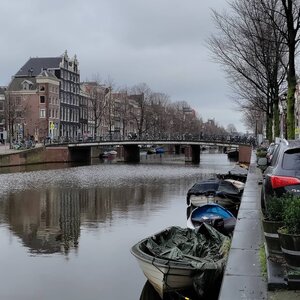
This requirement made them incompatible with the dense street patterns of Amsterdam’s inner city, and so they were placed at the edges: along the Lijnbaansgracht (which takes its own name from the same industry), in the western margins of the Jordaan, and along the northern stretches of the Singel where the city’s expansion met the open ground near the IJ waterfront. The northern Singel was, in the seventeenth century, a working waterfront zone as much as a residential one. Shipyards, chandleries, warehouses, and rope works clustered here because the city’s great maritime economy generated enormous demand for the goods they produced.
The scale of that demand is difficult to overstate. The Dutch East India Company (Vereenigde Oost-Indische Compagnie, or VOC), established in 1602, became within a generation the largest trading company in the world. A single VOC East Indiaman required several kilometres of rope to outfit its rigging: anchor cables, stays, halyards, sheets, braces, and hundreds of specialised smaller lines, all twisted from hemp at works like those that once operated near Bridge 10. The VOC’s central Netherlands headquarters, the Oost-Indisch Huis, sat only a short distance away at Kloveniersburgwal. The rope that left this part of the city went to the ends of the known world and back.
The lijnbaan that gave the bridge its name has not survived. It left only its name on the crossing that served it. But the spatial logic of the rope walk is still legible in the street pattern: the long straight stretches, the open ground, the emphasis on linear space rather than the tight interlocking plots of the older city. Look at a map of the northern Singel zone and you can see the memory of industrial geometry in the layout of the land.
From Timber to Fixed Span: The Structural History
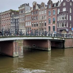
The first crossing at this location would have been a timber drawbridge, functional and replaceable rather than monumental, serving the flow of goods and workers between the Singel and the street pattern of the old city to the east. The drawbridge format was the standard for the Singel’s early crossings: the canal was, among other things, a working waterway, and tall-masted vessels needed to be able to pass.
The bridge evolved over the seventeenth and eighteenth centuries as the neighbourhood’s character shifted and the intensity of its use changed. The transition from a predominantly maritime-industrial zone to a mixed residential and commercial district brought a different kind of traffic: pedestrians, handcarts, then horse-drawn vehicles, and eventually the motor traffic and trams that would define the early twentieth century’s demands on Amsterdam’s infrastructure.
The decisive renovation came through the Dienst der Publieke Werken, the municipal Public Works Department that was responsible for Amsterdam’s systematic bridge-building and renewal programme across the late nineteenth and early twentieth centuries. Working within the design language established for the Singel bridge series, the department rebuilt Bridge 10 as a fixed span: a vaste brug of brick, granite, and steel that eliminated the drawbridge mechanism and lowered the profile of the deck to accommodate wheeled traffic without the camber of an older arched bridge. The flattening of the deck was not incidental; it was the specific adaptation that allowed the bridge to function as a modern urban crossing for the traffic between the Singel and the Blauwburgwal.
The resulting structure belongs to the family of Singel bridges that were renewed in the same period and share the same general architectural language, even where the individual execution differs slightly from bridge to bridge.
Amsterdam School Details in Stone and Iron
Bridge 10 carries the material signature of its renovation era. The brick abutments are laid in the warm-toned manner associated with the Amsterdam School movement (roughly 1910-1930), which brought an expressionist sensibility to brick construction throughout the city, including its bridges. The abutments are not merely functional supports; the brickwork is detailed with care for texture and the handling of planes.
At the corners of the abutments, where the masonry meets the canal’s surface, granite nose stones project slightly into the water. These rounded stone blocks, a consistent feature across the Singel bridge series, serve to deflect the hull of a passing barge away from the brickwork. They are also the most immediately legible indicator of the bridge’s period: the decision to use dressed granite for these elements, rather than the cheaper alternatives available, reflects the Publieke Werken’s commitment to durable, quality materials across the entire series.
The wrought iron railings follow the geometric patterning characteristic of this phase of Amsterdam bridge construction, where decorative ironwork was designed to the same standard of care as the structural elements. Across the Singel series, these railings were typically produced by specialist ironwork ateliers working from designs coordinated with the overall bridge scheme. The patterns vary from bridge to bridge in their specific detailing while remaining consistent in their general approach: geometric, restrained, and precisely worked.
Whether Piet Kramer was the specific designer responsible for Bridge 10’s renovation, as he was for several of the adjacent Singel crossings in the 1920s, is not confirmed by the sources presently available for this post. What is not in doubt is that the bridge falls within the design family he established, and that its material and decorative choices reflect the same coordinated programme.
The Blauwburgwal: The Canal That Fits in a Glance
The street on the east bank of Bridge 10 leads immediately into the Blauwburgwal, the short canal that runs between the Singel and the Nieuwezijds Voorburgwal. The Blauwburgwal is among the smallest canals in central Amsterdam, a waterway so compact that you can take in its full length in a single unhurried look from one end to the other. Where the Singel runs for over three kilometres and the Herengracht for more than two, the Blauwburgwal is a punctuation mark: brief, specific, and oddly charming for its restraint.
The name may carry a reference to a blue-coloured building or gate in the old city’s medieval structure, though the specific etymology is not definitively established in the historical record. What is certain is that the canal existed as part of the medieval city’s internal water system and survived the various expansions and reworkings of the city’s plan. It sits within what was the old town’s core rather than in the canal belt expansion, which gives its character a slightly different quality from the grander waterways that were cut deliberately to a design.
Crossing Bridge 10, you pass from the planned canal belt geometry of the Singel into the older, denser, more irregular fabric of the medieval city. The contrast is not dramatic from the bridge itself, but it is present in the scale of the buildings, the width of the streets, and the sense that the urban pattern around you is the product of accretion rather than design.
The Dome on the Water: The Round Lutheran Church
The Ronde Lutherse Kerk (Round Lutheran Church), also known as the Koepelkerk (Dome Church), stands near the northern Singel within easy sight of Bridge 10. It was built between 1668 and 1671 by the architect Adriaan Dortsman (1635-1682), who designed it as a centrally planned circular church for Amsterdam’s Lutheran congregation. The building is one of the very few round churches in the Netherlands, and its copper dome is one of the Singel’s most distinctive architectural presences.
The church’s history after the seventeenth century was not uncomplicated. In 1822 the Lutheran congregation merged with other Protestant bodies, and the church’s use changed accordingly. A fire in 1822 severely damaged the interior; the building was rebuilt with a new dome. By the twentieth century the building had passed out of active religious use and was eventually taken over by the Renaissance Amsterdam Hotel, which now uses it as a concert hall and conference venue. The dome, green with oxidised copper, remains intact.
From Bridge 10, looking along the Singel toward the Koepelkerk, the dome appears above the roofline and, on still water days, floats in the canal’s surface as a reflection. This is one of the Singel’s classic photographic compositions: the dome doubled in the water, the canal framing it symmetrically, the morning or evening light catching the copper surface. Photographers have worked this view for as long as the canal has been clear enough to hold a usable reflection. Stand at the bridge’s railing on a calm morning and you will understand immediately why.
Between the Nine Streets and the Old City
Bridge 10 sits just north of the Torensluis (Bridge 9) and outside the formal boundary of the Negen Straatjes (Nine Streets) shopping district, which reaches the Singel and ends at approximately that point. The bridge therefore occupies a transitional position: it is adjacent to one of Amsterdam’s most intensively visited tourist and shopping zones while belonging to a different urban zone, the northern Singel approach to the Brouwersgracht junction.
The Multatuli Museum at Korsjespoortsteeg 20, established in 1957 in the birthplace of Eduard Douwes Dekker, is within easy walking distance. Douwes Dekker’s bronze statue sits on the Torensluis, one bridge to the south, but his birthplace and the museum that commemorates his life and the reception of Max Havelaar is on a short alley that runs between the Singel and the adjacent canal. Bridge 10 forms part of the natural walking route between the Torensluis monument and the museum building.
The northern Singel near Bridge 10 is quieter than the stretch to the south. The Nine Streets crowds thin out past the Torensluis, and the area around the Blauwburgwal and the Koepelkerk has a more local character. It is a stretch of the canal where Amsterdam residents tend to outnumber tourists, which gives it the particular atmosphere of a working neighbourhood that happens to contain several centuries of accumulated urban history.
Heritage Status and Ongoing Stewardship
Bridge 10 forms part of the Singel bridge series that was designated as a protected heritage resource by the municipality of Amsterdam in October 1995, when 72 Singel bridges were registered collectively as gemeentelijk monumenten (municipal protected monuments). This bulk designation recognised the coherence of the series as an ensemble rather than evaluating each bridge individually, and it committed the municipality to the maintenance and conservation of the bridges’ historic fabric.
The bridge is constructed in brick, granite, and steel, in the fixed plate bridge format standard for the renovated Singel crossings. Routine inspection and maintenance are carried out by the municipality as part of its ongoing stewardship of the bridge stock; no major structural intervention has been publicly documented at Bridge 10 in recent decades. The heritage designation imposes constraints on any modifications to the visible historic fabric: the brickwork, granite elements, ironwork railings, and general proportions of the bridge are protected from alteration under the monument registration.
Looking at the Bridge Twice
Bridge 10 rewards two kinds of attention. The first is the view it offers: south along the Singel toward the Torensluis and beyond, or toward the Koepelkerk dome and its canal reflection. On a clear day in low light, the photographic composition from the bridge’s railing requires almost no adjustment. The canal frames everything.
The second kind of attention is to the bridge itself: the granite corners, the brickwork, the ironwork pattern in the railings, the low flat profile that represents the choice of a generation of municipal engineers to prioritise movement over ceremony. The Lijnbaansbrug is not the most architecturally dramatic bridge in the series. It does not have the historical weight of the Torensluis or the dual-etymology complexity of Bridge 8. What it has is a name that leads directly into the working history of the city at the height of its global trade empire: the rope walks that supplied the VOC’s ships, the hemp and the tar, the rope-makers walking backward across long straight ground while the Singel carried the traffic of the world.
The industry is gone. The name remains. The bridge still crosses.
Sources: Stadsarchief Amsterdam, historical maps of the northern Singel and Lijnbaan district (17th-19th century); Municipality of Amsterdam, gemeentelijk monument designation records, 10 October 1995 (72 Singel bridges); Dienst der Publieke Werken, bridge renovation records, Singel series; Rijksdienst voor het Cultureel Erfgoed, heritage records for the Singel bridge series; Adriaan Dortsman, architectural documentation of the Ronde Lutherse Kerk, 1668-1671 (Stadsarchief Amsterdam); VOC charter and company records, Nationaal Archief, The Hague; Multatuli Museum, Korsjespoortsteeg 20, Amsterdam (established 1957); Vereniging de 9 Straatjes founding records (12 November 1996).
Key Facts at a Glance
| Official name | Lijnbaansbrug |
| Bridge number | 10 |
| Location | Singel, at Blauwburgwal |
| Heritage status | Gemeentelijk monument (municipal protected monument), designation 10 October 1995 |
| Type | Fixed bridge (vaste brug), brick, granite, and steel |
| Name etymology | Lijnbaan (rope walk) + brug (bridge): named for the rope-making works that operated near this location |
| Rope walk function | Long straight strips of land for twisting hemp rope; supplied the VOC and Amsterdam’s maritime industries |
| Blauwburgwal | Among the shortest canals in central Amsterdam; runs from the Singel to the Nieuwezijds Voorburgwal |
| Nearby landmark | Ronde Lutherse Kerk (Koepelkerk), built 1668-1671 by Adriaan Dortsman; dome visible and reflected in the Singel from the bridge |
| Photography | Classic view of the Koepelkerk dome and its canal reflection from the bridge railing |
| Position in series | Just north of Bridge 9 (Torensluis); transitional zone between the Nine Streets and the northern Singel |
| Nearby museum | Multatuli Museum, Korsjespoortsteeg 20 (birthplace of Eduard Douwes Dekker, est. 1957) |
| Design period | Early 20th century, Publieke Werken renovation; Amsterdam School design vocabulary |
| Bridge to the south | Bridge 9 (Torensluis): Amsterdam’s oldest and widest open bridge |
.jpg/1200px-2022_Brug_10%2C_Lijnbaansbrug%2C_Asd-zijaanzicht_(3).jpg)

Like most of our bridges so far including the previous bridge Torensluis there has been a bridge at the location of Lijnbaansbrug for centuries.
The bridge is drawn on the map of Pieter Bast dating from 1599. There the bridge is located in the Lijnbaan Steech to the Blaeuwe Burchwal. Also Balthasar Florisz. van Berckenrode with his map of a quarter of a century later has drawn the bridge. Reinier Vinkeles captured the bridge in a drawing in 1785. The modern history of the bridge begins in 1883, when a fixed bridge was erected only on pile foundations to replace a drawbridge. This bridge began to show signs of deterioration in 1962, with cracks forming in the abutments. The bridge piers were also no longer upright because of the many collisions they suffered and the road surface no longer met the requirements. The municipality released a budget of 398,000 guilders to also widen the bridge from 5.40 to 9 meters. The work lasted until at least 1964, as witnessed by a photo in Algemeen Handelsblad , which showed that a dragline, including the flat barge on which it stood, had sunk in the Singel. At the time, Amsterdam had its bridges designed by the Public Works Department , where Dick Slebos and Dirk Sterenberg designed most of the bridges. However, this bridge was designed by Cornelis Johannes Henke (initial CJH). The bridge is slightly skewed over the water. The bridge is surrounded on four sides by all kinds of municipal or national monuments . She herself is too young for that.
Like the Lijnbaanssteeg, the bridge is named after the ropeways of the rope mills, which were located here when the area outside the Singel (then the city boundary) was still an industrial area.
Architects Dienst de Publieke Werken (Public Works Department)
1963: Cornelis Johannes Henke


Bridge number 10 (Brug Tien) Lijnbaansbrug or Line track bridge. This bridge connects Lijnbaanssteeg with the southern quay of Blauwburgwal and spans the Singel. Just like the Lijnbaanssteeg, the bridge is named after the line lanes of the rope-makers that were located here when the area outside the Singel (then city boundary) was still a kind of industrial estate. Not to be confused with Lijnbaansgracht, named after the same industry but in a completely different area.
Architects Dienst de Publieke Werken (Public Works Department)
1963: Cornelis Johannes Henke
North along the Singel canal in Amsterdam from the Torensluis lies Lijnbaansbrug Bridge 10.
Lijnbaansbrug is drawn on the map of Pieter Bast dating from 1599. There the bridge is located in the Lijnbaan Steech to the Blaeuwe Burchwal. Also Balthasar Florisz. van Berckenrode with his map of a quarter of a century later has drawn the bridge. Reinier Vinkeles captured the bridge in a drawing in 1785.
https://w3w.co/slipped.plodded.minus
https://w3w.co/begrijp.ringvinger.afdrogen
///slipped.plodded.minus
///begrijp.ringvinger.afdrogen
52.37628, 4.891282
This what3words address refers to a 3 metre square location. Tap the link or enter the 3 words into the free what3words app to find it.