Unnamed bridge. Connected to Hans van Mierlo Bridge 18.
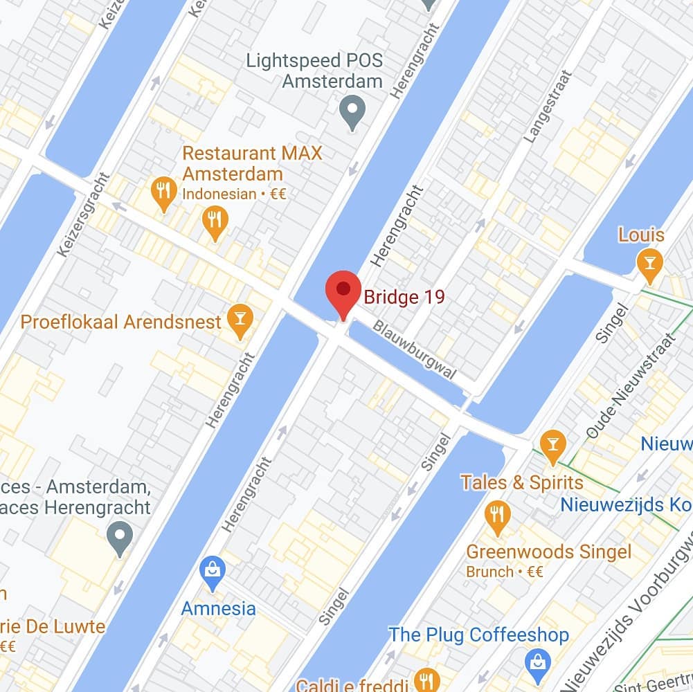
Bridge 19 in Amsterdam is located in the eastern bank of the Herengracht spanning Blauwburgwal it forms a whole with bridge 18 on the southern quay of the Blauwburgwal and across the Herengracht. These corner style bridge connections are frequent so that unlike say bridge 17 one does not need to go down a block to be able to cross the Herengracht.
How Brug 19 Became the Quiet Anchor of the Blauwburgwal
In the intricate choreography of Amsterdam’s bridges, some are destined for fame while others are content to play a supporting role. Just steps from the newly named Van Mierlobrug, tucked against the eastern quay of the Herengracht, lies its quiet partner: Brug 19. This unassuming span over the Blauwburgwal has no official name, no political homage, and no picturesque nickname. Yet its story is inseparable from its more famous neighbor, bound by shared history, a common architect, and a narrow escape from a World War II bomb. To understand the northern edge of the Herengracht, you must cross Brug 19.
A Nameless Bridge with a Numbered Dignity
Unlike the bridges we have explored to the west, Brug 19 carries no romantic moniker. In the municipal ledgers, it is simply Brug 19, a designation from the efficient cataloging system of Amsterdam’s Public Works Department. This anonymity is not a mark of neglect, but rather a testament to its purely functional role. It is the eastern counterpart to the Van Mierlobrug (Brug 18), together forming a continuous crossing over the Herengracht and the Blauwburgwal.
There is no record of a local nickname or a historical trade association. Its identity is defined by its location: the bridge in the eastern quay of the Herengracht (oostelijke kade van de Herengracht) that spans the Blauwburgwal . In a city where every corner seems to have a story, Brug 19’s story is one of quiet, steadfast service.
From Fortress Ditch to Modern Crossing: Four Centuries of Change
The history of a bridge at this spot is as ancient as that of its neighbor. The great cartographer Pieter Bast recorded a crossing here on his map of 1599 , when the Herengracht was still the outer defensive moat (vestinggracht) of a city bursting its medieval seams. By the time of Balthasar Florisz. van Berckenrode’s detailed 1625 map, the bridge was clearly marked, spanning the Blaeuwe Burchwal (Blauwburgwal) from the quay of the Heere Graft (Herengracht) .
For much of its early life, it was likely an arched stone bridge, a welfbrug. A tantalizing clue comes from the painter Herman Misset, who sketched a bridge on this spot bearing the date 1791 in its arch. However, as the Wikipedia article notes, the sketch lacks a firm date, leaving us with a suggestive but unconfirmed possibility .
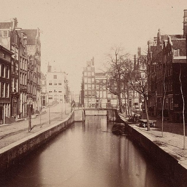
What is certain is that by the late 19th century, the bridge had been transformed. Photographs from around 1870 by Pieter Oosterhuis, one of Amsterdam’s earliest photographers, show a liggerbrug (girder bridge) , a flat, industrial structure of iron and stone . This was the same era that saw the “lowering” of Brug 18. By 1887, complaints were already being raised that Brug 19, like its partner, was too high for the increasing volume and weight of horse-drawn traffic . The city’s response is not recorded in detail, but the bridge clearly remained in its girder form for decades to come.
The Bomb and the Shared Fate
On May 11, 1940, Brug 19 shared the terrifying experience of its neighbor. When a German bomb destroyed the corner buildings at Blauwburgwal 25-27 and Herengracht 105-107 , the bridge itself survived . It was a narrow escape, a reminder that even anonymous infrastructure stood on the front lines of history.
Dirk Sterenberg’s Historical Homage: The 1977 Design
By the 1970s, the 19th-century girder bridge was aging. In a coordinated effort with the replacement of Brug 18, the city decided to rebuild Brug 19 as well. Between October 1976 and July 1977, a new bridge was constructed . And just like its partner, the design was entrusted to Dirk Sterenberg of the Dienst der Publieke Werken .
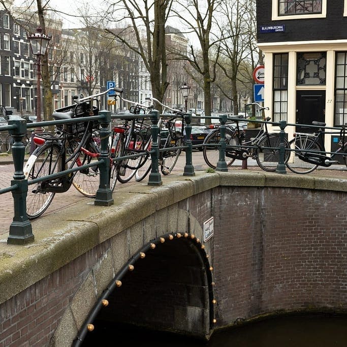
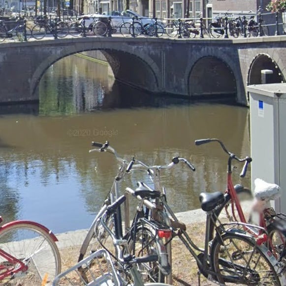
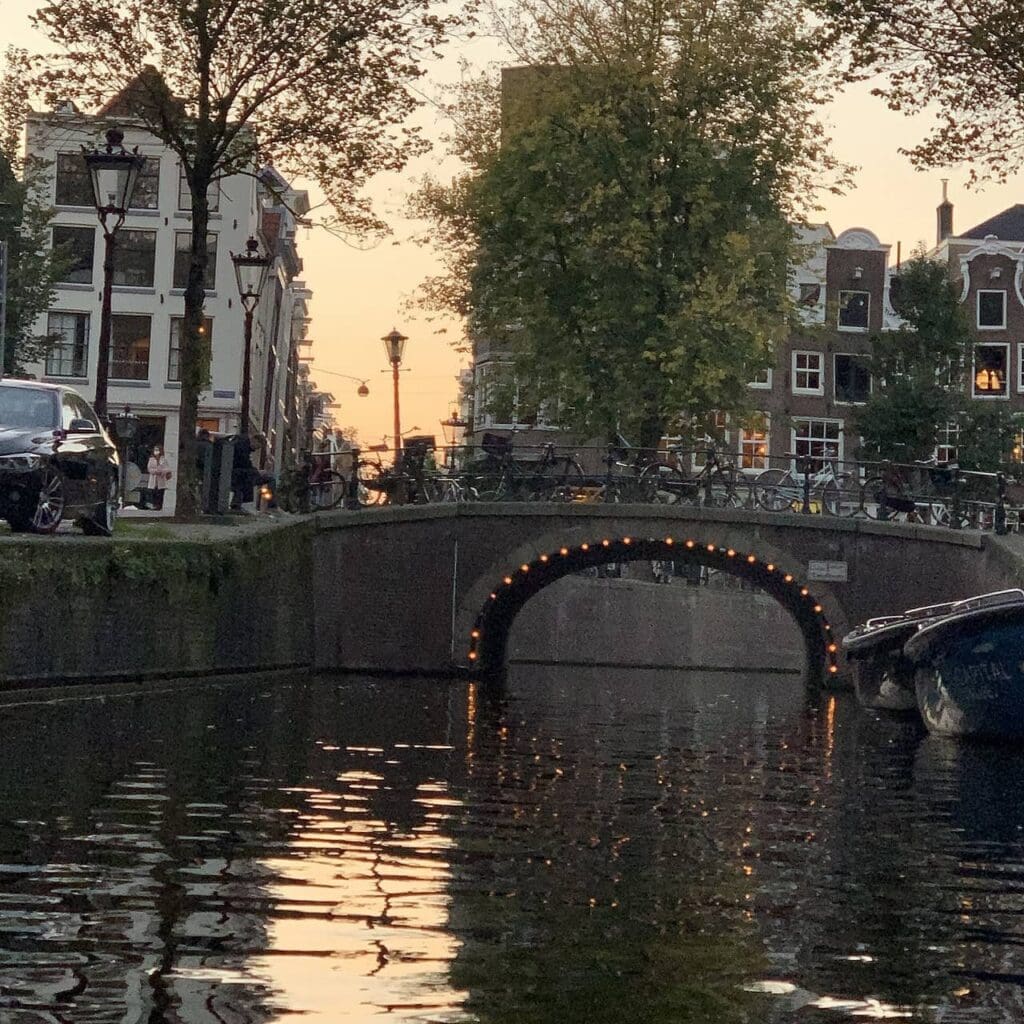
Sterenberg, however, made a fascinating choice. While he gave Brug 18 five arches to span the wide Herengracht, for the narrower Blauwburgwal he designed a single-arch bridge (boogbrug) . This single, graceful vault is a deliberate echo of the bridge’s probable 17th and 18th-century form. It is a piece of historical stagecraft, using modern materials (reinforced concrete faced with brick) to recreate a classic profile.
The result is a bridge that feels both old and new. Its single arch is elegant and uncluttered, allowing unobstructed views down the intimate Blauwburgwal. The brickwork blends seamlessly with the monumental facades of the surrounding buildings, which are a mix of gemeentelijke en rijksmonumenten (municipal and national monuments) . The bridge itself, completed in 1977, is too young for such status, but it performs a crucial architectural function: it completes the historical picture.
The Quiet Connector: Urban Context
Brug 19 plays a specific and vital role in the neighborhood’s geography. It carries traffic (pedestrians, cyclists, and cars) from the eastern quay of the Herengracht across the Blauwburgwal, connecting to the area around the Oude Spiegelstraat and the western edge of the Amsterdam University complex.
It does not offer the grand, postcard-perfect view down the Brouwersgracht that draws crowds to the Melkmeisjesbrug. Instead, its views are more intimate and local. Stand on Brug 19 and look south: you see the Herengracht stretching away, with the arch of Brug 18 in the distance. Look north: the Blauwburgwal opens up, lined with historic buildings, including the post-war reconstruction on the bombed corner, a quiet scar of history. Look east: you see the gabled roofs of the buildings on the Blauwburgwal itself.
Its function today is that of a vital local connector, a verkeersbrug (traffic bridge) that is essential for daily movement but rarely the destination itself. It lives in the shadow of its named partner, but without it, the entire circulation pattern of this historic quarter would be broken.
Technical Specifications: The Single Arch
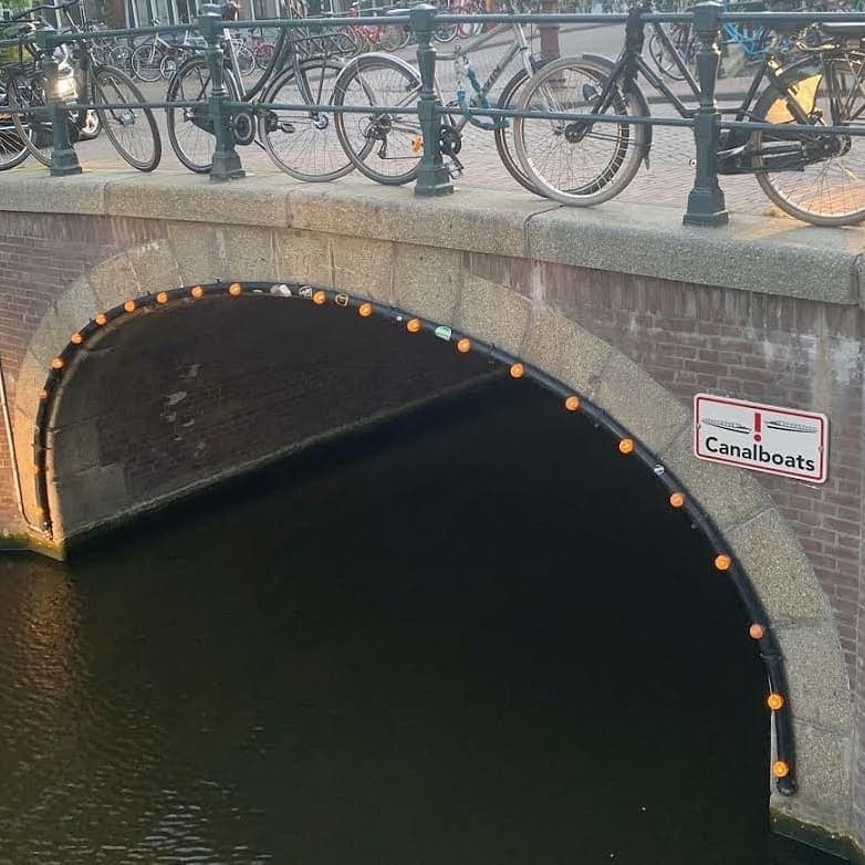
- Type: Vaste brug (Fixed bridge). A boogbrug (arch bridge) with a single span.
- Materials: The arch is constructed of reinforced concrete, faced with traditional baksteen (brick) . Stone, likely granite, is used for the keystone and water-facing elements. The deck is asphalt over a concrete base.
- Architect: Dirk Sterenberg, Dienst der Publieke Werken (1977 design).
- Current Use: Mixed traffic (vehicles, cyclists, pedestrians).
In conclusion, Brug 19 is the unsung partner in a beautiful architectural duet. It may lack a famous name or a blockbuster view, but its single arch is a masterful piece of historical design by Dirk Sterenberg, a quiet anchor that grounds the Blauwburgwal in its centuries-old past while serving the practical needs of the present. It is a reminder that in Amsterdam, even the anonymous bridges have stories worth telling.
Sources and Further Reading
Primary Sources & Archival References
- Stadsarchief Amsterdam (Amsterdam City Archives)
- Archief van de Publieke Werken (Public Works Department archives), dossiers betreffende de vernieuwing van brug 19, 1976/1977 (likely filed with or near Brug 18’s dossier 55966).
- Bouw- en vergunningstekeningen (Building and permit drawings) for the 1976/1977 bridge.
- Fotocollectie: Photographs by Pieter Oosterhuis, circa 1870, showing the earlier girder bridge.
- Cartographic Sources
- Bast, Pieter (1599). Kaart van Amsterdam. Stadsarchief Amsterdam.
- Florisz. van Berckenrode, Balthasar (1625). Kaart van Amsterdam. Stadsarchief Amsterdam.
- Municipal Registries
- Basisregistratie Adressen en Gebouwen (BAG), gemeente Amsterdam. Entry for Brug 19 via data.amsterdam.nl.
- Rijksmonumentenregister (National Monument Registry), entries for surrounding buildings on the Herengracht and Blauwburgwal.
Online Databases & Historical Websites
- Wikipedia contributors. (2023, February 3). “Brug 19 (Amsterdam).” Wikipedia, De vrije encyclopedie. https://nl.wikipedia.org/wiki/Brug_19
- Korrel, Peter. “Brug 19 in de Herengracht over de Blauwburgwal.” Bruggen van Amsterdam. https://bruggenvanamsterdam.nl/ (Search for Brug 19).
- data.amsterdam.nl. Entry for Brug 19 via Basisregistratie Adressen en Gebouwen (BAG).
Historical Context & Further Reading
- Smit, Frank V. (2008). Bruggen in Amsterdam. Uitgeverij Matrijs. (Provides context on Dirk Sterenberg’s work and the design philosophy of 1970s bridge building in Amsterdam).
- Gawronski, J., & Veenman, R. (2018). *De Amsterdamse bruggen: Bouw en ontwikkeling 1850-1950*. Uitgeverij Thoth. (For understanding the earlier 19th-century girder bridge documented by Oosterhuis).
- Mak, Geert. (1995). Een kleine geschiedenis van Amsterdam. Uitgeverij Atlas. (Essential context for the development of the Herengracht and Blauwburgwal area).
Image Collections
- Wikimedia Commons. “Categorie: Brug 19.” https://commons.wikimedia.org/wiki/Category:Brug_19
- Beeldbank Stadsarchief Amsterdam. Photographs of Brug 19 and the surrounding area, including images by Pieter Oosterhuis (circa 1870) and documentation of the 1940 bomb damage. https://archief.amsterdam/beeldbank/

Brug negentien – Bridge 19 | History and information
The history of bridge 19 in Amsterdam bears a resemblance to that of bridge 18. According to painter Herman Misset, the bridge once bore the year 1791 in the arch, but the drawing is missing a date. Another drawing by him from the period 1891 to 1901 and also a photo by Pieter Oosterhuis from around 1870 show a girder bridge. In 1887 comments were already made about this bridge being too high for traffic. The current bridge dates from July 1977 when, after a few months of work, a new arch bridge with a passage was built.


Brug negentien – Bridge 19 | Map and location
The road bridge number 19 in Amsterdam is located in the eastern framework of the Herengracht and spans the Blauwburgwal . The bridge forms a whole with bridge 18 in the southern quay of the Blauwburgwal and across the Herengracht.