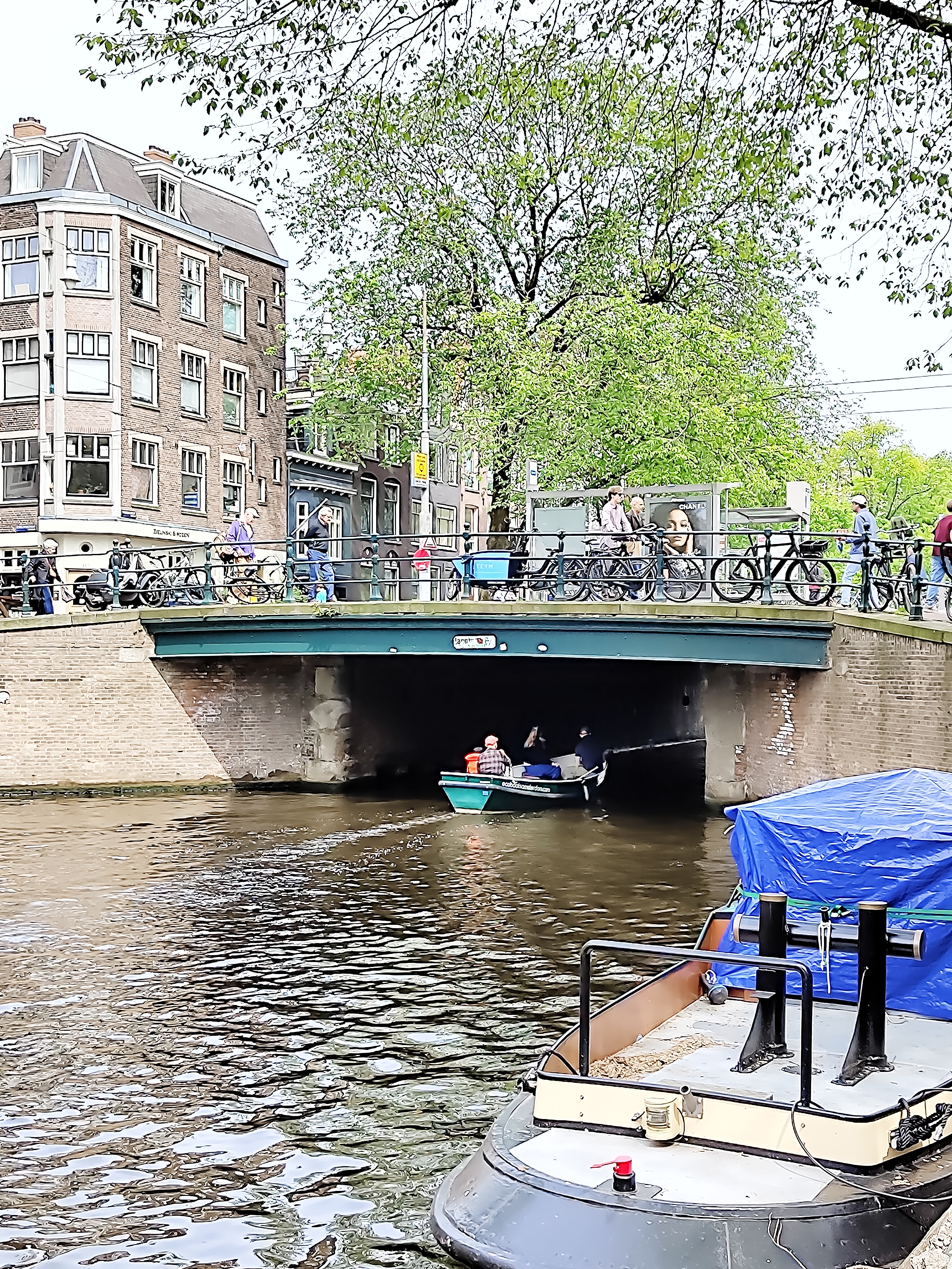
A Fixed Bridge in the Utrechtsestraat, Where a Seventeenth-Century Sluice Lost Its Purpose and a Street Lost Its Chance
Last time we looked at Brug 74, the Kerksluis on the Reguliersgracht, a bridge whose distinction is everything that never happened to it: it kept its stone arch when the rest of the city was being flattened for trams, and on a still morning it still throws a perfect circle onto the water. Brug 75, a few minutes’ walk east, is its opposite in almost every respect. This one was lowered. This one was widened. The trams came, and the bridge was rebuilt to suit them.
And yet Brug 75 turns out to be defined by absences too; three of them, spread across three and a half centuries. A sluice that was made redundant in 1673. A grand plan for the street above it that was abandoned in 1907. And a replacement bridge that was cancelled in the early 2010s because a sister bridge’s rebuild had gone badly wrong. Brug 75 is a crossing shaped, again and again, by decisions taken elsewhere about other things.
Location: The Last Bridge Out of Town
Brug 75 is a fixed traffic bridge in Amsterdam-Centrum, carrying the Utrechtsestraat over the Prinsengracht. It is the last bridge of the Utrechtsestraat as you head out of the city; a distinction it holds only by default. The bridge that once continued the sequence, over the Achtergracht, was demolished when that canal was filled in, and the street’s run of crossings simply stops here.
Counted the other way — along the water rather than along the street — it is the second-to-last bridge over the Prinsengracht before the canal empties into the Amstel at the Frans Hendricksz. Oetgensbrug, Brug 76. Upstream sits Brug 74. Brug 75 therefore occupies a genuine edge: the point where the planned geometry of the canal ring runs out and the river takes over.
That position explains almost everything else about it. A bridge at the meeting point of an engineered canal system and a tidal river is not an ordinary crossing. It is a control point, and for the first fourteen years of its existence that is exactly what it was.


The Street It Carries: Six Hundred Metres of the Road to Utrecht
The Utrechtsestraat was laid out in the seventeenth century as part of the Golden Age expansion that produced the canal ring itself. Its name is a destination rather than a description: this was the road towards Utrecht, the way out of the city to the south-east, and the street still carries the name of a place fifty kilometres away.
It runs roughly six hundred metres, crossing the Herengracht, the Keizersgracht and the Prinsengracht in turn — a bridge at each. Today it is one of the more agreeable shopping streets in the centre, dense with independent shops, boutiques, delicatessens and restaurants, and conspicuously free of the international chains that have colonised the Kalverstraat and the Leidsestraat. Grocers, booksellers, shoe specialists, kitchenware, jewellery: it is a street that has kept a working retail mix rather than a tourist one.
Hold that character in mind, because the most consequential thing that ever nearly happened to Brug 75 was a plan that would have destroyed it.
Structural Evolution: Stalpaert’s Inner Sluices and the Line of Three
There has been a structure at this point for centuries, and originally it was not primarily a bridge at all. It was a sluice, with a bridge over it.
City architect Daniël Stalpaert marked sluices here on his design map of 1662, describing them as inner sluices intended to hold back water from the Amstel. Jacob Bosch’s map of around 1679, depicting the Fourth Expansion, likewise shows a lock with a bridge crossing at this location. This was not ornament and it was not incidental. The Amstel is a river, historically tidal, subject to levels and to salt intrusion that the city could not control, and the freshly dug canal ring needed defending from it.
Brug 75 was not alone in the task. Comparable sluices stood where the Utrechtsestraat crossed the Keizersgracht at Brug 37 and the Herengracht at Brug 34. The three formed a staged defensive line of inner locks along a single street, each guarding one ring of the canal system against water pushing in from the east. Walk the six hundred metres of the Utrechtsestraat today and you are walking the line of a seventeenth-century flood-control system, three crossings deep, invisible in every respect except that the bridges are still there.
Johannes Hudde, the Amstelsluizen of 1673, and the Fifteen Years That Made It Obsolete
In 1673 the city built the Amstelsluizen — the Amstel locks — and the entire arrangement became redundant.
The project came on the initiative and to the design of Johannes Hudde, mathematician and burgomaster of Amsterdam, working with Gerard Hasselaer and Cornelis van Oudshoorn. Hudde is one of the more remarkable figures in the city’s administrative history: a serious mathematician who corresponded on the theory of equations and on probability, and who then spent decades applying that mind to the practical hydraulics of a city built on water. The Amstelsluizen are his monument.
The problem he was solving was filth. The Amstel and the Burgwallen had become badly polluted as the city grew, and the water needed verversing — refreshing, flushing through. The locks were built to control the flow so that clean water could be drawn through the canal system and stale water expelled, and they simultaneously prevented salt water from the IJ pushing up into the Amstel. After they were built, the water refreshed better and the pollution eased.
The design evolved during planning. Two lift locks were initially intended; this became three — one large lock in the middle with a smaller one on either side — and between the outer lift locks and the two Amstel quays a spillway lock was provided. The complex still stands in the Amstel between the Prinsengracht and the Singelgracht, in front of the Koninklijk Theater Carré, and it is a national monument.
For Brug 75 the consequence was immediate and terminal. Once the river was controlled at a single point downstream, there was no longer any purpose in maintaining a chain of inner sluices further in. The evidence of what followed is cartographic: by the time of Frederik de Wit’s map of 1688, the sluices have gone from the Utrechtsestraat and low bridges are shown in their place.
Fifteen years, then, from critical hydraulic infrastructure to ordinary street crossing. Brug 75 has been a bridge ever since, but it began as something more important, and it stopped being that not through failure or neglect but because the city solved the problem better, somewhere else. It is a very Amsterdam sort of obsolescence: the water was managed so successfully that the machinery for managing it could be dismantled.
Architectural Lineage: Lowered and Widened for the Omnibus Company’s Trams
The nineteenth century brought the change that Brug 74 escaped. The bridges of the Utrechtsestraat were prepared for the arrival of trams operated by the Amsterdamsche Omnibus Maatschappij, and Brug 75 — together with two others on the same street, its old sluice partners — required lowering and widening to carry them.
This is the process that reshaped central Amsterdam between roughly 1880 and 1910. The arched profiles that suited barges gave way to flat decks that suited rails and wheels, one bridge at a time, street by street, almost always over the objections of the skippers who lost headroom by it. The Kerksluis at Brug 74 survived because it sat on a quiet side canal that no tram route needed. Brug 75 sat on a main street heading out of the city, and had no such luck.
The three Utrechtsestraat bridges were altered together, as they had been built together two centuries earlier. Their shared history is unusually tight: constructed as a line of sluices, rebuilt as a line of tram bridges, and — as we shall see — entangled once more in the twenty-first century.
Urban Context: The Radial Route That Went to the Vijzelstraat Instead
In 1907 the Utrechtsestraat came close to a far more dramatic transformation. Officials considered widening the street to 25 metres, converting it into a radial traffic artery running out from the centre — the same treatment that had already erased the Rozengracht further west and driven the Raadhuisstraat through the historic blocks north of it.
Twenty-five metres is worth visualising. The Utrechtsestraat is a narrow street of modest frontages; widening it to that dimension would have meant demolishing or refronting most of its buildings along six hundred metres, and rebuilding all three of its canal bridges at a far greater scale. Brug 75 would not have survived in any recognisable form.
The costs were judged prohibitive. The plan was dropped, and the Vijzelstraat became the chosen radial route instead — widened in 1917 and again in 1926, and developed as the main artery running from the centre out towards the south, later carrying the principal public transport route towards Centraal Station.
The two streets make an instructive pair. The Vijzelstraat got the investment, the width and the traffic, and is admired by almost nobody; its scale sits awkwardly against the canal houses it cut through. The Utrechtsestraat was passed over, stayed narrow, kept its shopfronts, and is now one of the most pleasant streets in the centre. Brug 75 remains a modest bridge because a budget did not stretch in 1907.
There is a final twist. Having lost the argument to be the radial route, the Utrechtsestraat got a tram anyway: in 1948 the route of tram line 4 was shifted onto it. The street was spared the demolition but still ended up carrying the rails — which is to say that Brug 75, lowered and widened in the nineteenth century for the Omnibus Company, has been earning that alteration ever since.
The Replacement That Was Cancelled
The most recent reprieve is nearly within living memory. During the renovation of the Utrechtsestraat between 2009 and 2011, Brug 75 was scheduled for replacement.
It was not replaced. Construction errors at Brug 34 — one of the two sister crossings that had once held the same line of inner sluices — caused the programme to be reconsidered, and the work at Brug 75 was postponed. The bridge came through the renovation unmodified.
There is a pleasing symmetry to it. Brug 34 and Brug 75 were built as partners in a seventeenth-century water-defence system, altered together for the trams in the nineteenth century, and then, three hundred and forty years after Stalpaert drew them, a mistake made on one was the reason the other survived intact. Infrastructure has a long memory, even when the people using it have none.
Where the Prinsengracht Ends
Stand on Brug 75 and look south-east along the water and you are looking at the last stretch of the Prinsengracht. The canal was dug as the outermost of the three great rings of the seventeenth-century expansion — the Herengracht for the wealthiest, the Keizersgracht for the merchants, the Prinsengracht more modest and more mixed, with warehouses and workshops among the houses.
One bridge further on, at the Frans Hendricksz. Oetgensbrug, the Prinsengracht meets the Amstel and stops. Beyond that is the river, and the Amstelsluizen sitting in it in front of Carré — the very structure whose construction in 1673 stripped Brug 75 of its original job.
It is a short view with a long argument in it. Within perhaps four hundred metres of this bridge deck lie the end of the canal ring, the river it was defended against, and the locks that settled the matter. Brug 75 is not a famous bridge and it will not appear on a postcard, but it stands at the exact point where Amsterdam’s greatest piece of urban planning meets the water it was built to control.
Technical Specifications
- Bridge number: 75
- Name: None (unnamed)
- Type: Fixed traffic bridge (vaste verkeersbrug)
- Spans: Prinsengracht
- Carries: Utrechtsestraat
- Coordinates: 52° 21′ 44″ N, 4° 53′ 56″ E
- Original function: Inner sluice with bridge, holding back water from the Amstel
- Recorded: Stalpaert design map 1662; Jacob Bosch map c. 1679; Frederik de Wit map 1688 (as a low bridge)
- Made obsolete by: The Amstelsluizen, 1673 — designed by Johannes Hudde
- Lowered and widened: For trams of the Amsterdamsche Omnibus Maatschappij
- Sister sluices: Brug 37 (Keizersgracht), Brug 34 (Herengracht)
- Neighbours: Brug 74 upstream; Frans Hendricksz. Oetgensbrug (Brug 76) downstream at the Amstel
- Tram: Line 4 routed onto the Utrechtsestraat in 1948
- Replacement: Planned for the 2009–2011 Utrechtsestraat renovation, postponed after construction errors at Brug 34
Sources Consulted
- Brug 75, Nederlandstalige Wikipedia
- Amstelsluizen, Nederlandstalige Wikipedia
- Waterschap Amstel, Gooi en Vecht — 1673: De Amstelsluizen
- Rijksmonumenten.nl, monument 518510 — Amstelsluizen
- Daniël Stalpaert, design map of Amsterdam, 1662
- Jacob Bosch, map of the Fourth Expansion, c. 1679
- Frederik de Wit, map of Amsterdam, 1688
- Bruggen van Amsterdam
- Stadsarchief Amsterdam Beeldbank — Prinsengracht gezien vanaf Brug 75 in de Utrechtsestraat; photograph of 1875
- Algemeen Handelsblad, 7 February 1885
- Wikimedia Commons, Category: Brug 75 (in Amsterdam)