
Our first bridge spanning Herengracht the Van Mierlobrug (brug 18). Just like bridge 10 & bridge 11 this bridge forms a whole with next bridge 19 which is on the eastern quay of Herengracht and across Blauwburgwal. Built in the 70’s it is not a monument although obviously given it’s in the world famous canal ring it is surrounded by National monuments on Herengracht. The bridge was named in January 2021 after D66 founder Hans van Mierlo who lived nearby and walked across this bridge to his pub. So new I couldn’t find a name plate but thankfully the internet to the rescue and someone else has since taken a picture (see below).


The Philosopher’s Crossing: How the Van Mierlobrug Became a Bridge of Bombs, Bureaucracy, and Memory
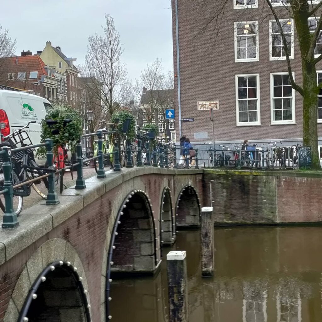
At the northern tip of the Herengracht, where Amsterdam’s most aristocratic canal begins its journey south, a curious bridge spans the water. It looks, at first glance, like a classic Amsterdam vault bridge, its five brick arches rising gently from the water. But this is a deception, a masterful piece of 20th-century historical mimicry. This is the Van Mierlobrug (Bridge 18), a structure with a story that stretches from the city’s earliest days as a fortified town to a German bomb in 1940, and finally to a quiet political homage in the 21st century. It is a bridge of layers, each one waiting to be peeled back.
A Name Born of Politics and Proximity: The Van Mierlobrug
Unlike its neighbors named for milkmaids or colonial companies, this bridge’s name is thoroughly modern. In January 2021, the City of Amsterdam officially christened it the Van Mierlobrug, after Hans van Mierlo (1931-2010) , the founder of the social-liberal political party D66 .
The name was not chosen at random. Van Mierlo was a beloved figure in Dutch politics, but more importantly for this story, he was a local. He lived in the neighborhood, on the Herengracht itself. The bridge was his personal path to the city’s life. As the Wikipedia article notes, he walked over this very bridge to reach his local pub . The name, therefore, is a rare example of a bridge honoring not a grand historical event, but the daily rhythm of a notable resident’s life, his stamkroeg (regular bar) just steps away.
This naming was also the resolution of a minor bureaucratic drama that had played out a few years earlier. As we learned in the story of the West-Indische huisbrug, the Van Mierlo name was originally proposed in 2016 for that bridge (Brug 17), after a city error suggested it was unnamed. When that error was corrected, the proposal was politely shelved, only to be resurrected for this crossing . It is a fitting end: the bridge Van Mierlo actually used now bears his name.
From Fortress Graft to Modern Arches: A 400-Year Evolution
The history of a crossing at this spot is as old as the Herengracht itself. The great cartographer Pieter Bast drew a bridge here on his map of 1599 , at a time when the Herengracht was not a genteel residential canal but the outer defense moat (vestinggracht) of a rapidly expanding city. By the time of Balthasar Florisz. van Berckenrode’s 1625 map, it was already depicted as a substantial welfbrug (vault bridge) with five passages , the northernmost bridge over the Heere Graft .
For centuries, it served its purpose. But by the late 19th century, it had become a problem. In 1879, the bridge was in the news for being “hinderlijk hoog” (obstructively high) for the increasingly heavy horse-drawn traffic . The city, perpetually short of funds, did nothing. Then, in 1883, an accident underscored the urgency. A horse and cart, descending the steep arch, crashed into the water. The horse and its load were saved, but the coachman, thrown against a tree, was seriously injured and taken to the hospital .
This finally spurred action. In 1890, funds were approved, and by the autumn of 1891, a new, lowered bridge was nearing completion. This was almost certainly a liggerbrug (girder bridge) , a modern, flat structure designed for easier passage . This bridge, with its clean, industrial lines, served the city for over 80 years.
The Bomb and the Narrow Escape
This 1891 bridge had a dramatic encounter with history. On May 11, 1940, the day after the German invasion of the Netherlands, a bomb fell in the neighborhood. It destroyed the corner buildings at Blauwburgwal 25-27 and Herengracht 105-107 . The bridge itself survived, but only just. The modern photograph in the Wikipedia article shows the post-war new construction on that corner, a permanent scar reminding us of the bridge’s brush with destruction .
The Historian’s Touch: Dirk Sterenberg’s 1977 Design
By the 1970s, the 1891 girder bridge was likely showing its age and struggling with modern traffic loads. Between October 1976 and April 1977, it was completely replaced . The architect for this new bridge was Dirk Sterenberg of the Dienst der Publieke Werken (Public Works Department) .
Sterenberg faced a fascinating challenge. The site demanded a bridge that could carry traffic, fit the historic surroundings, and span the considerable width of the Herengracht. His solution was a masterful piece of historical pastiche. He designed a welfbrug (vault bridge) with five arches , returning to the form of the original 17th-century crossing. But this was not a sentimental copy; it was a pragmatic choice.
As bridge expert Frank V. Smit noted in 2008, the use of five smaller arches instead of a single large one achieved two things . Aesthetically, some might find it less elegant than a single, sweeping arch. But practically, it allowed the bridge to have a much flatter profile, making it easier for traffic while still providing the necessary strength to span the wide canal . Sterenberg, who designed numerous “historical” bridges for Amsterdam, proved that modern engineering could wear a classic disguise with dignity and purpose. He even designed new railings for it, completing the period look with clean, functional lines.
The Northern Anchor: Urban Context
The Van Mierlobrug occupies a critical junction. It connects the Herenstraat on the west to the Blauwburgwal on the east, spanning the Herengracht at its northernmost point. It is the bookend to the grand canal. To the south, the Herengracht stretches away, lined with the monumental homes of Golden Age merchants. To the north, just beyond the bridge, lies the Brouwersgracht and the area we’ve explored in previous investigations, the historic maritime district.
The bridge is surrounded by a rich collection of gemeentelijke en rijksmonumenten (municipal and national monuments) , though the bridge itself, built in 1977, is too young for such a status. Today, it functions as a vital verkeersbrug (traffic bridge) , carrying cars, cyclists, and pedestrians. It does not offer a single, world-famous view like the Melkmeisjesbrug, but rather a series of intimate perspectives: down the Herengracht, into the rebuilt corner of the Blauwburgwal, and towards the historic Herenstraat.
Technical Specifications and the Weight of Memory
- Type: Vaste brug (Fixed bridge). A welfbrug (vault or arch bridge) .
- Number of Arches: Five.
- Materials: Brick arches with stone detailing, likely granite for the water-facing elements. Steel or concrete for the internal structure, faced with brick.
- Architect: Dirk Sterenberg, Dienst der Publieke Werken (1977 design).
- Current Use: Mixed traffic (vehicles, cyclists, pedestrians).
The Van Mierlobrug is a palimpsest, a manuscript written and rewritten over four centuries. It carries the memory of a fortified city, a 19th-century accident, a wartime bomb, a 1970s architect’s skillful homage, and finally, the footsteps of a modern political thinker heading to his local pub. It reminds us that every bridge in Amsterdam is not just a way across the water, but a way through time itself.
Sources and Further Reading
Primary Sources & Archival References
- Stadsarchief Amsterdam (Amsterdam City Archives)
- Archief van de Publieke Werken (Public Works Department archives), dossier 13018 betreffende brug 18 uit 1891.
- Archief van de Publieke Werken, dossier 55966 betreffende de vernieuwing van brug 18 uit 1977 (ontwerp Dirk Sterenberg).
- Bouw- en vergunningstekeningen (Building and permit drawings) for the 1891 and 1976/1977 bridges.
- Cartographic Sources
- Bast, Pieter (1599). Kaart van Amsterdam. Stadsarchief Amsterdam.
- Florisz. van Berckenrode, Balthasar (1625). Kaart van Amsterdam. Stadsarchief Amsterdam.
- Municipal Registries & Official Documents
- Basisregistratie Adressen en Gebouwen (BAG), gemeente Amsterdam. Entry for Van Mierlobrug via data.amsterdam.nl.
- Gemeente Amsterdam (2021, February 3). “Naamgeving openbare ruimten: Vaststellen Van Mierlobrug in stadsdeel Centrum.” Gemeenteblad, 2021-32299. (Official naming decision).
- Rijksmonumentenregister (National Monument Registry), entries for surrounding buildings.
Online Databases & Historical Websites
- Wikipedia contributors. (2022, August 4). “Van Mierlobrug.” Wikipedia, De vrije encyclopedie. https://nl.wikipedia.org/wiki/Van_Mierlobrug
- Korrel, Peter. “Van Mierlobrug, brug 18 in de Herenstraat over de Herengracht.” Bruggen van Amsterdam. https://bruggenvanamsterdam.nl/herengracht_hoek_brouwersgracht.htm (Accessed 27 June 2022).
- data.amsterdam.nl. Entry for Van Mierlobrug via Basisregistratie Adressen en Gebouwen (BAG).
Historical Context & Further Reading
- Smit, Frank V. (2008). Bruggen in Amsterdam. Uitgeverij Matrijs. (Contains the critical observation on the five-arch design by Dirk Sterenberg).
- Gawronski, J., & Veenman, R. (2018). *De Amsterdamse bruggen: Bouw en ontwikkeling 1850-1950*. Uitgeverij Thoth. (For understanding the broader context of Publieke Werken bridge design, including the 1891 replacement).
- Mak, Geert. (1995). Een kleine geschiedenis van Amsterdam. Uitgeverij Atlas. (Provides essential context for the development of the Herengracht from a defensive moat to a residential canal).
- Het Parool. (January 2021). Newspaper articles regarding the naming of the Van Mierlobrug. (Referenced in Wikipedia article).
- Amsterdam, Nieuws uit B&W. (2021, January 28). Announcement of the bridge naming. (Referenced in Wikipedia article).
Image Collections
- Wikimedia Commons. “Categorie: Brug 18.” https://commons.wikimedia.org/wiki/Category:Brug_18
- Beeldbank Stadsarchief Amsterdam. Photographs of Brug 18 and the surrounding area, including images of the bomb damage from 1940 and the various bridge incarnations. https://archief.amsterdam/beeldbank/

Hans van Mierlobrug – Bridge 18 | History and information
Like many of the other bridges there has been a bridge here for centuries although the current incarnation is relatively new.
The bridge was replaced between October 1, 1976 and April 30, 1977 by a new arch bridge, again with five passageways. The design of this classic looking bridge comes from Dirk Sterenberg of the Public Works Department. He designed more historic bridges in Amsterdam and also designed new handrails. The bridge was named in January 2021 after D66 founder Hans van Mierlo who lived nearby and walked across this bridge to his pub.


Hans van Mierlobrug – Bridge 18 | Map and location
Brug Achttien is a road bridge connecting the southern quay of Blauwburgwal with Herenstraat over Herengracht. The bridge forms a whole with bridge 19 in the eastern quay of Herengracht and across Blauwburgwal.
As you will have seen in the last post this bridge only recently became Hans van Mierlo Bridge as the West-Indische huisbrug almost became the Hans van Mierlo Bridge in 2016 because of a clerical error.
