The Nesciobrug: Amsterdam’s Literary Eel That Swam Across the Rhine
A Bridge Unlike Any Other
Let me confess something. When I first started to investigate Brug 2013, I assumed my notes would fill a few quiet pages. Another functional crossing, I thought. Another piece of municipal infrastructure designed by some forgotten Publieke Werken engineer. I could not have been more wrong.
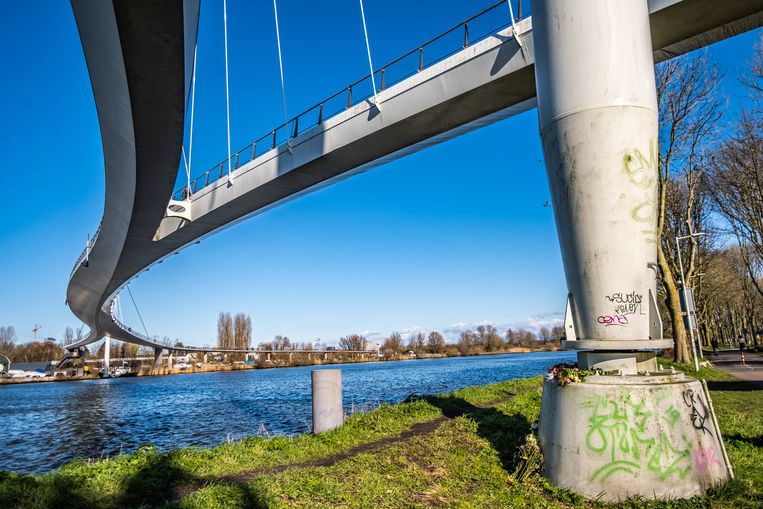
The Nesciobrug defies everything Amsterdam’s bridge tradition represents. Where the Canal Ring offers low, intimate stone arches and brick barrel vaults, this structure soars. Where the city’s historic crossings huddle close to the water, this one rises ten meters clear for the commercial barges that grind beneath it. And where our beloved Amsterdam School bridges announce themselves with decorative masonry and bridge keeper houses, the Nesciobrug arrives like a creature from another century entirely. A steel eel. A harp strung across the water. A literary homage cast in 780 meters of engineering audacity.
Let us walk this bridge together. I will show you what I found in the archives, on the canal bank, and in the strange silence of a suspended bicycle path at sunrise.
Designated as bridge number 2013 in Amsterdam’s numbering system, is a remarkable feat of engineering named in honour of the renowned Dutch writer, Nescio. This elegant curved bridge features a hang-cable-stayed design, making it one of the longest and most impressive bicycle and pedestrian bridges in the Netherlands. Stretching an impressive 780 meters in total length, the Nesciobrug stands as a testament to both modern engineering prowess and its tribute to the literary legacy of Nescio.
Location
The Nesciobrug gracefully stretches over the Amsterdam-Rhine Canal, forming a vital link between Amsterdam and Diemen, while providing a direct pathway to IJburg through the Diemerzeedijk and the Diemerpark. Positioned adjacent to the Seabed Bridge in the A10 highway, this bridge significantly enhances the cycling connectivity between IJburg and Diemen, as well as the neighborhoods of Watergraafsmeer and the wider Amsterdam East district. With the Nesciobrug, commuting and exploring these areas have become faster and more accessible, fostering a seamless integration between the various parts of this vibrant region.
Etymology and Naming: The Writer on the Dyke
The name Nesciobrug honours a man who never held public office, never designed a building, and never captained a vessel. J.H.F. Grönloh wrote under the pen name Nescio, Latin for “I do not know.” He was a businessman by trade, a writer by calling, and a walker by obsession.
In the early years of the twentieth century, Nescio and his friends made long rambles along the Diemerzeedijk, the clay dyke that separates the reclaimed polder from the Amsterdam-Rijnkanaal. He turned these walks into literature. The 1918 collection of three stories, simply titled “Nescio,” captured something essential about Dutch restlessness, about young men gazing eastward across the water toward something they could not name. The Diemerzeedijk entered the collective literary memory because one man walked it and wrote it down.
When the bridge finally touched down on that same dyke in 2006, the choice of name felt less like christening and more like recognition. The municipality had found its poet.
But Amsterdammers, being Amsterdammers, had another name ready. The bridge’s long, curved, silvery form earned it the nickname “Palingbrug” or Eel Bridge. A high literary reference and a working-class fish joke coexist on every sign, every conversation, every GPS coordinate. That is Amsterdam in miniature.
A note for the historically minded: this bridge required political manoeuvering worthy of the Golden Age. The municipality of Diemen consistently opposed the development of IJburg, the artificial island neighbourhood this bridge serves. When Amsterdam needed a cycling connection from IJburg to the city centre, Diemen refused cooperation. The Nesciobrug therefore sits entirely on Amsterdam territory, tracing a careful diagonal across the canal to avoid Diemen’s jurisdiction. The city literally bent its bridge around a neighbour’s intransigence.
Structural Evolution: From Pontoon to Pylon
Here is where my initial research assumptions collapsed entirely. The Nesciobrug has no 17th century wooden ancestor. No stone arch was flattened in the 19th century to accommodate tram lines. No Amsterdam School architect added decorative railings to an existing crossing.
There was never a bridge here at all.
Before 2006, the only way across the Amsterdam-Rijnkanaal at this point was a vehicular ferry, a “rijdende pont” that rolled on wheels along a rail submerged six meters deep. A single diesel mechanic operated the crossing. In good weather, this sufficed. In fog or winter ice, when the channel had to be kept clear for commercial traffic, the crossing became dangerous. After twenty one years of service, the pont made its final passage in 1972. For the next three decades, cyclists and pedestrians who needed to cross this stretch of canal simply could not.
The canal itself had grown. Originally excavated as the Merwedekanaal in the late 19th century, it was absorbed into the new Amsterdam-Rijnkanaal in 1952 and widened to eighty meters. Later expansion to one hundred meters left no room for the old pont. Commercial shipping demanded clearance. The port of Amsterdam, the fifth busiest in Europe, sends its vessels through this channel toward the Rhine and the German industrial heartland. Any new crossing had to lift itself out of the water’s way.
Thus the Nesciobrug was born not from evolution but from necessity. A clean slate. A 21st century solution to a 20th century problem.
Architectural Lineage: London Vision on Amsterdam Water
Do not search the Publieke Werken archives for these drawings. You will not find Piet Kramer’s signature masonry or Jo van der Mey’s sculptural railings. The Amsterdam School left its mark on hundreds of city bridges, but not this one.
The Nesciobrug arrived from London. Architect Jim Eyre of WilkinsonEyre Architects won the commission, collaborating with engineering giants Arup (known for the Sydney Opera House and the Centre Georges Pompidou) and the Dutch firm Grontmij. The construction cost ran to approximately €9.5 million, a figure that raised eyebrows at the time and seems almost modest today.
The design breaks every local rule. Instead of a central arch or a bascule leaf, the Nesciobrug deploys a single self anchored cable, a suspension system more common to mountain gorges than Dutch lowlands. The Netherlands offers notoriously soft soil, which makes traditional suspension bridges difficult. Anchor blocks sink. Cables lose tension. Eyre solved this by anchoring the cables not to the ground but to the bridge deck itself, a self contained system that carries its own tension.
The main span stretches 163.5 meters, pre fabricated as a single steel structure weighing 510 tons. On July 9, 2005, workers hoisted it into place in a single half day operation, minimizing disruption to the busy waterway below. The bridge’s triangular cross section serves two purposes: it provides stiffness for the long span, and its angled sides make the structure nearly invisible to marine radar. A stealth bridge for commercial shipping.
The approaches are where the design reveals its wit. To achieve the required 10 meter clearance while keeping the gradient gentle enough for cyclists, the bridge needs long ramps. The southern end spirals into an expansive concrete curve. The northern end bends along the Diemerzeedijk. Foot traffic splits from bicycle traffic at both ends, with staircases offering a shortcut for pedestrians willing to climb.
This is not a bridge you cross indifferently. This is a bridge that asks you to move with it, to curve and rise and descend in a choreographed sequence.
Technical Specifications: The Dampers That Saved the Crossing
Total length: 780 meters, making the Nesciobrug one of the longest cycle and footbridges in the Netherlands.
Longest span: 163.5 meters.
Clearance below: 10 meters (33 feet), sufficient for the tallest commercial barges on the canal.
Materials: Steel for the main span, concrete for the approach ramps.
Deck width: Split into a 1.5 meter footpath and a 3.5 meter cycle track.
Bridge number: 2013 in the Amsterdam municipal registry.
Opening date: June 7, 2006 for cyclists, though pedestrians could cross as early as April 9 of that year before a temporary closure for finishing work.
But these figures miss the most extraordinary technical feature. The bridge is flexible by design. Too flexible, as it turned out. When pedestrians walk across a long suspension span, their footsteps can synchronize with the bridge’s natural vibration, creating a dangerous wobble. The Millennium Bridge in London famously swayed so badly on its opening day that authorities closed it for two years of retrofitting.
The Nesciobrug’s engineers learned from that embarrassment. They installed three tuned mass dampers, essentially heavy pendulums that absorb vibrational energy. The primary damper weighs 10,000 kilograms and sits at mid span, damping the first vibration mode to 5% of critical damping. Two smaller dampers of 1,500 kilograms each sit at the quarter and three quarter points, damping the second vibration mode to 7.5%.
These dampers are invisible to the casual user. The bridge feels solid, stable, safe. But beneath the deck, a 10 ton pendulum swings silently, constantly, correcting for forces you cannot perceive. That is engineering as stealth magic.
Urban and Social Context: Connecting the Archipelago
The Nesciobrug does not belong to the Canal Ring or the Jordaan or Oud West. It belongs to the eastern water frontier, the zone where the city meets the IJ and the reclaimed islands beyond.
The bridge connects three worlds. On the western bank, the Diemerpark and the Amsterdam Science Park, a landscape of former landfill being reclaimed as public green space. On the eastern bank, IJburg itself, an archipelago of artificial islands that represents Amsterdam’s most ambitious residential expansion since the Canal Ring. In between, the Amsterdam-Rijnkanaal, one of Europe’s busiest inland waterways, carrying coal, chemicals, and containers past a bicycle path suspended above the wake.
This is a commuter bridge. IJburg residents use it to reach the city center without circling through the eastern docklands. Diemen residents use it to reach the parks and schools on the IJburg side. The route gets busier every year as IJburg grows, and the municipality is currently redesigning the intersection at the bridge’s northeastern end to accommodate rising cyclist numbers.
But the Nesciobrug is also a destination. Photographers gather at sunset to capture the long curve against the water. Cyclists climb the ramp for the reward of the downhill rush on the other side. Walkers pause mid span to watch the barges slide beneath, their bridges of the old city. The bridge offers a vantage point no 17th century tower can match: the sensation of floating above commerce, suspended between water and sky, connected to the earth only by two slender points of contact.
—
Sources and Further Reading
Amsterdam City Archives (Stadsarchief). Search Brug 2013 or Nesciobrug in the Beeldbank for construction photography and municipal records.
Bruggen van Amsterdam (bridgesofamsterdam.nl). Peter Korrel’s comprehensive database includes the Nesciobrug with technical specifications and historical context.
Arcam Amsterdam Architecture Guide. Entry on the Nesciobrug with design analysis and urban context.
Flow Engineering. Technical documentation on the tuned mass damper system.
Wikipedia Nederlandse and English editions. Bridge specifications, naming history, and construction timeline.
History
In 1952, the Merwedekanaal underwent a transformation, becoming part of the new Amsterdam-Rhine Canal and was widened to 80 meters. A significant development came in 1951 when a free ferry truck was constructed at the Veerhuis on Ouddiemerlaan. This innovative moving ferry operated on wheels along a rail, propelled by a diesel engine at a depth of approximately 6 meters. While the single-operator operation was manageable in good weather, adverse conditions like fog or winter frost posed challenges in keeping the channel ice-free. After providing 21 years of service, the ferry’s last voyage took place in 1972. With the widening of the canal to 100 meters, there was no space left for the ferry, leading to the necessity of using the Amsterdam Bridge or Weesper Bridge for transportation.
The municipality of Diemen consistently opposed the development of IJburg, and when a bicycle connection between IJburg and Amsterdam Center became necessary, Diemen did not cooperate. As a result, the location of the bridge falls entirely within Amsterdam’s territory instead of Diemen’s.
Finally, on April 9, 2006, the bridge was opened to pedestrians, welcoming them to traverse the canal with ease. Soon after, on June 7, 2006, cyclists also gained access to the bridge, further enhancing the connectivity and accessibility between IJburg and Amsterdam Center. This bridge stands as a symbol of progress, fostering better transportation options and facilitating the movement of people between these vibrant areas.
Design
The bridge is designed by Jim Eyre in collaboration with engineering firms Grontmij and Arup.